|
|
||||||||
| EXISTING STATIONS | ||||||||
|---|---|---|---|---|---|---|---|---|
| Station Name |
Original Railroad |
Current Location |
Type | Current Use |
Date Built |
Track Status |
Building Material |
More Info |
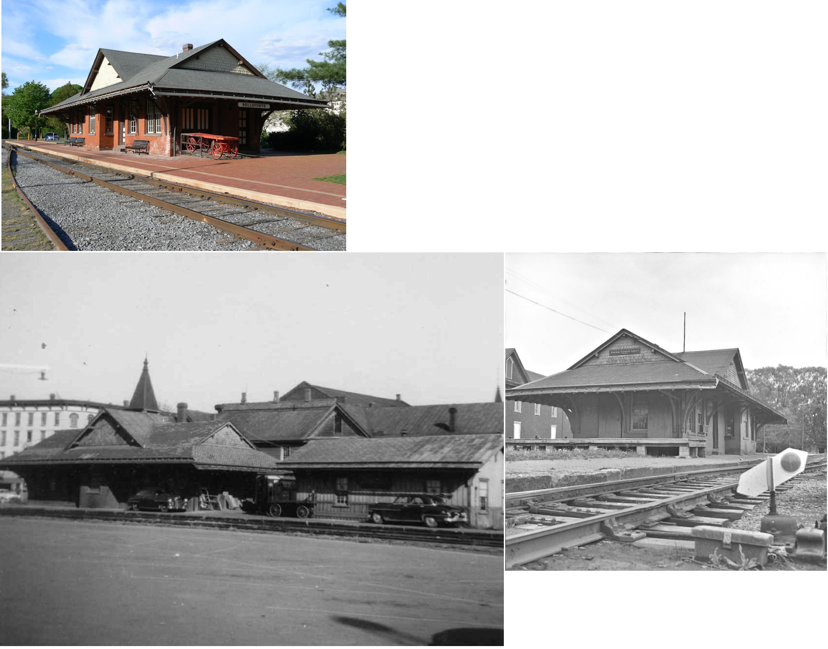
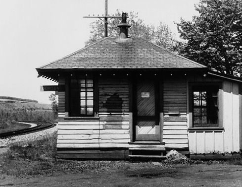
| Bellefonte |
 AND  |
320 West High Street (GPS: 40.911319, -77.781847) |
P | RR & Civic | 1889 | In Use | Brick |
|
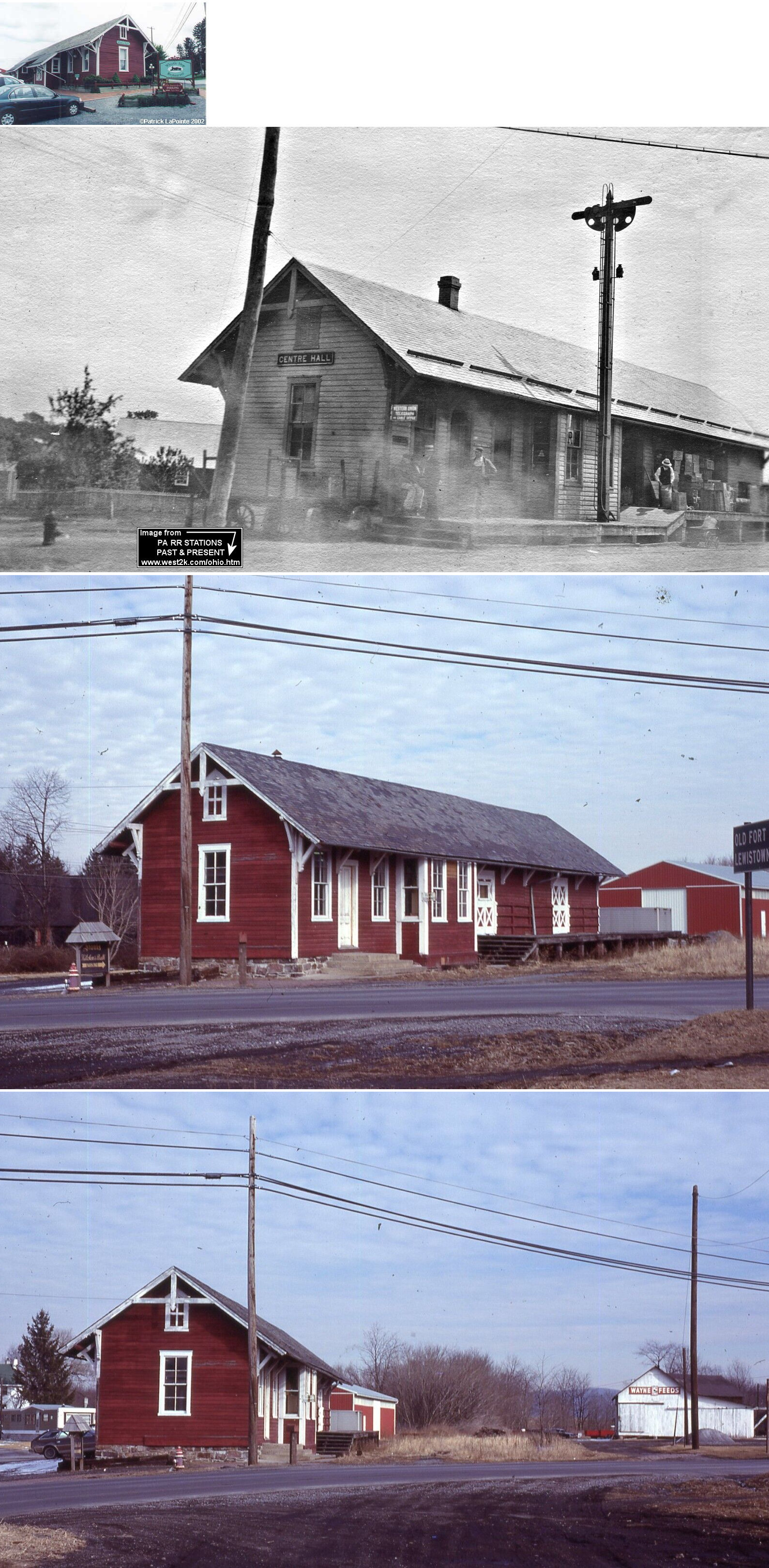
| Centre Hall |
 |
104 East Wilson Street (GPS: 40.840049, -77.677810) |
P | Business | 1885 | Gone | Wood |
|
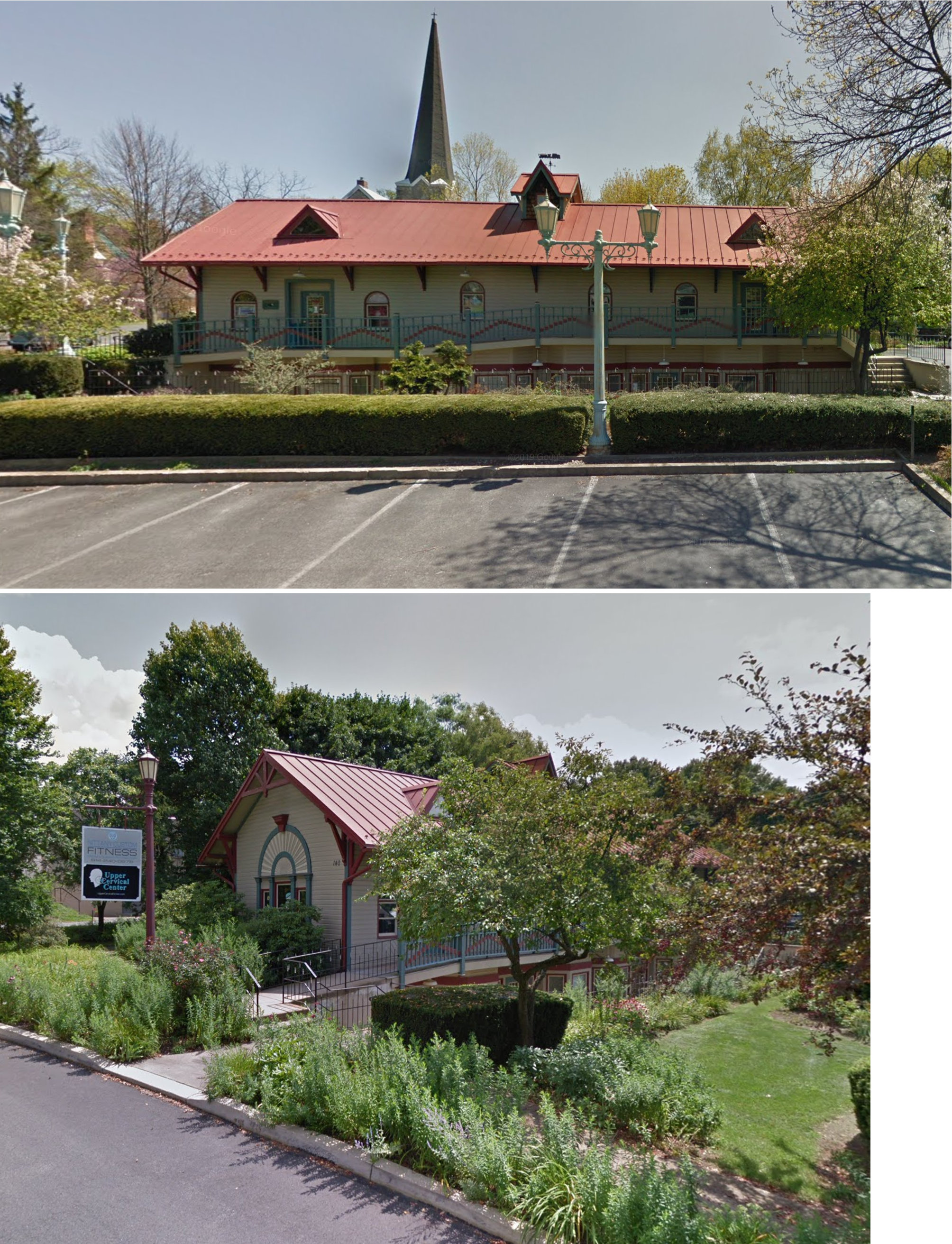
| Lemont |
 |
140 Mary Street (GPS: 40.809301, -77.817686) |
C | Business | 1990 | In Use | Wood |
|
| Snydertown |
 |
Behind Centre Hall PRR station at 104 East Wilson Street in Centre Hall (GPS: 40.840049, -77.677532) |
P | Storage | ???? | Gone | Wood | |
| State College |
|
152 North Atherton Street (on Railroad Avenue) (GPS: 40.792125, -77.867827) |
C | Business | 1900 | Gone | Brick |
|
| STATIONS OF THE PAST | ||||||||
| Station Name |
Original Railroad |
Notes | ||||||
| Aqua (Water Tank Sta.) |
|
This station was on the Snow Shoe Branch of the PRR. It was originally the Bellefonte & Snow Shoe RR which ended its independent operation in January 1881, when it was sold to the Bald Eagle Valley Railroad, long a subsidiary of the PRR. The Bellefonte & Snow Shoe and the Moshannon Railroads were merged into the Bald Eagle Valley in 1881 to become the Snow Shoe Branch. The station was originally called Water Tank Station, but the name was changed in May, 1881. | ||||||
| Axemann |
|
|||||||
| Bellefonte |
|
The original wooden frame combination station here was at the same site of the extant brick station at 320 West High Street (GPS: 40.911319, -77.781847). This old station can be seen on the 1887 Sanborn map. | ||||||
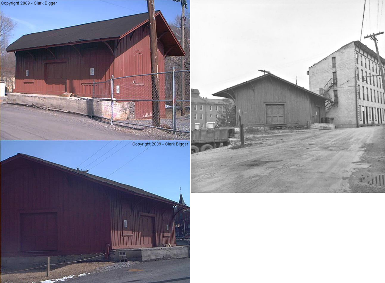
| Bellefonte |
|
This freight station was on Dunlop Street just north of High Street at GPS: 40.912169, -77.781487. This station is the original freight house and is labeled as such on the map from 1874. This station was likely retired when the new freight station was constructed on North Potter Street in the late 1800s. It is identified on old Sanborn maps as an agricultural implements warehouse and storage from 1887-1922. | ||||||
| Bellefonte |
|
There was a freight station on North Potter Street on the
west side of the tracks at GPS:
40.912898, -77.782700. That station may have sat where north Potter
Street is today at this location as there were more tracks here in the
past. The Adams Express office was part of a large complex of buildings on the corner of High Street and Dunlop Street at GPS: 40.911725, -77.781347. |
||||||
| Bellefonte |
|
The original wood frame station was on North Water Street just south of Lamb Street at GPS: 40.914012, -77.781863. | ||||||
| Bellefonte |
|
Sometime between 1904-1911 a new brick passenger station was built at the corner of West Lamb Street and North Water Street (which is the old RR grade). This passenger station was at GPS: 40.914300, -77.782310. A new wooden freight house was build next to the passenger station on the south side. After the railroad went under and the tracks were taken up, the passenger and freight stations were sold and served as the office and storage for the Chemical Lime Company until at least until 1922 (it is shown as such on the Sanborn Map for that year). | ||||||
| Bloomsdorf |
|
|||||||
| Boynton |
 |
|||||||
| Briarly |
|
|||||||
| Butts (Beech Creek) |
|
This station was on the Snow Shoe Branch of the PRR between Rhodes and Fountain. In May, 1881 the PRR changed the name of this station from Beech Creek to Butts likely to avoid confusion with the Beech Creek in Clinton County. | ||||||
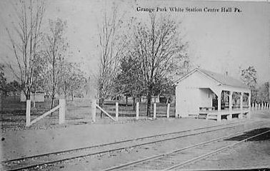
|
Centre Hall (Grange Park Station) |
|
|||||||
| Chemical |
|
Site of Chemical Lime/National Gypsum/Domtar plant. Unclear if there was a station here. | ||||||
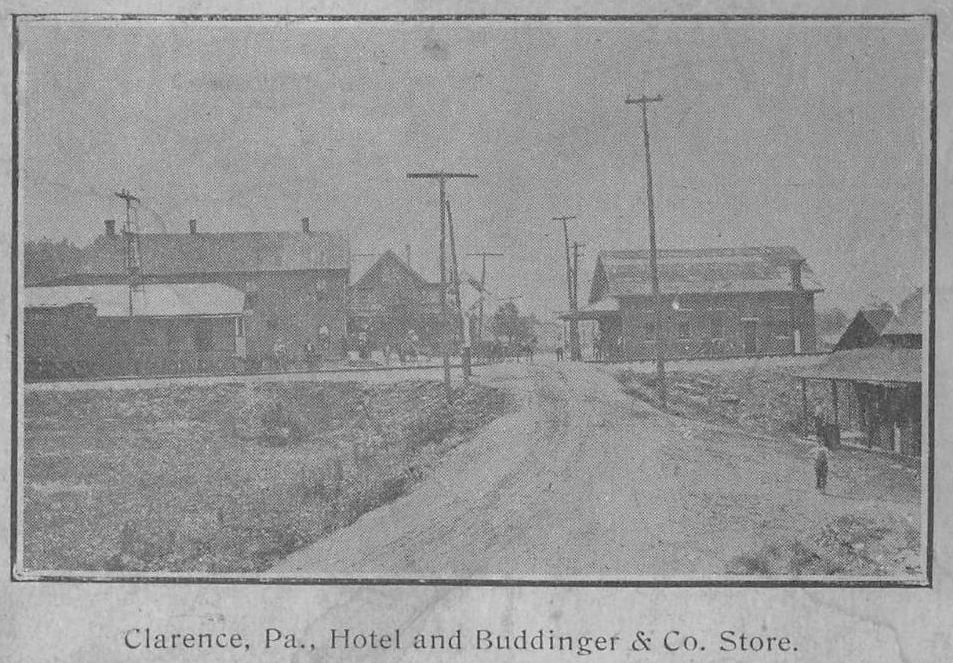
| Clarence (Snow ShoE Sta.) |
|
See listing below for Beech Creek station at Snow Shoe. | ||||||
| Clarks Station |
|
This station was on the Snow Shoe Branch of the PRR. | ||||||
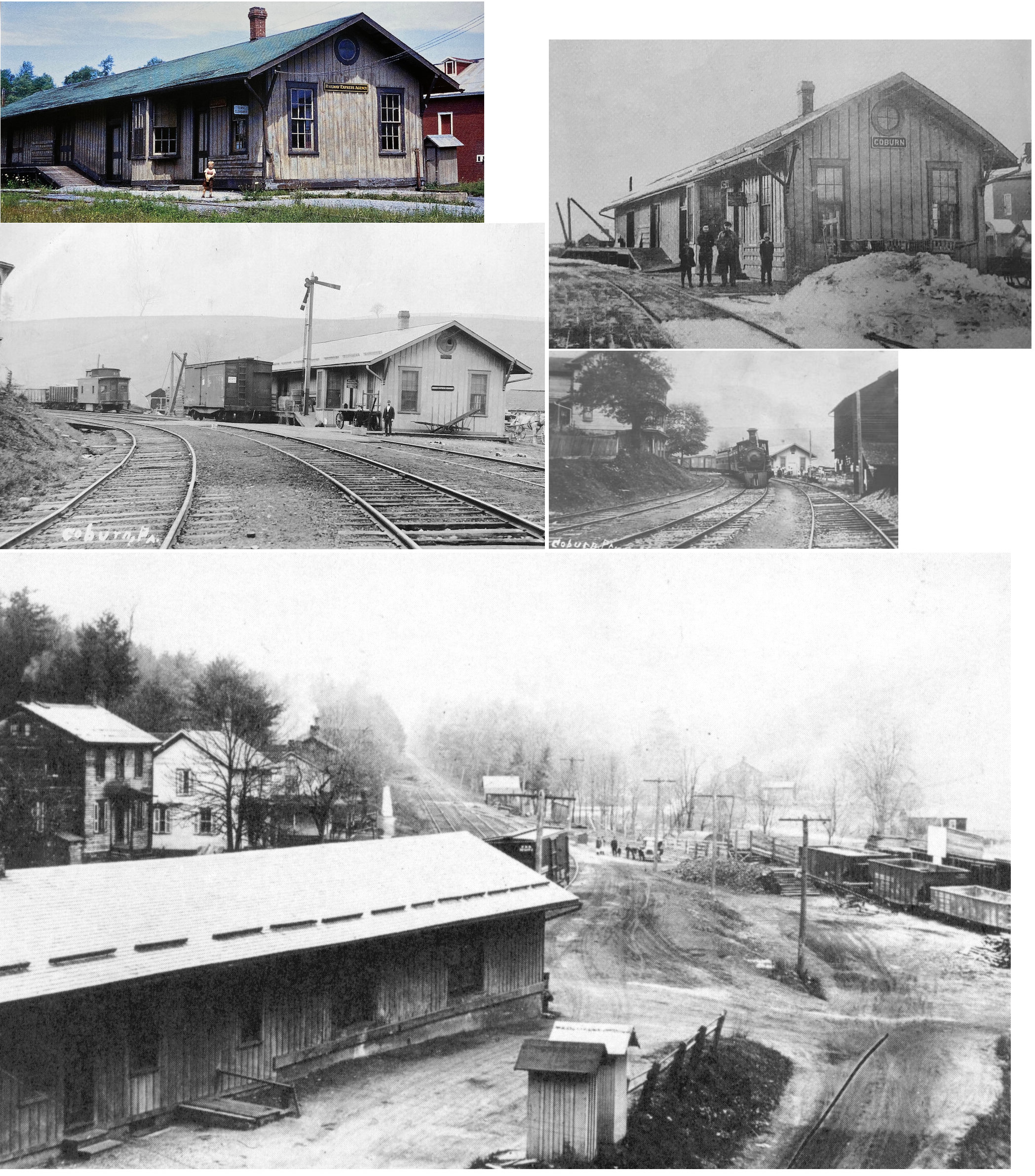
| Coburn |
|
This combination station was on Railroad Street. It was built in 1873, closed in 1959, and was torn down in 1962. | ||||||
| Coleville |
|
The station was on the south side of Lower Coleville Road at approximately GPS: 40.909278, -77.794469. | ||||||
| Curtain Station (Roland) |
|
|||||||
| Dale Summit |
|
|||||||
| Dix |
|
Not to be confused with Dix Station in Clarion County. | ||||||
| Dunkles |
|
|||||||
| Eagleville |
|
In 1874 there was a passenger station near the corner of Eagleville Road and Railroad Street at GPS: 41.056575, -77.592564. There was a freight depot on the SW side of Eagleville Road at GPS: 41.056340, -77.592894. | ||||||
| Edendale |
|
|||||||
| Fairbrook |
|
This was the junction of the Scotia Branch. The Juniata Branch that lead to the Juniata Mines branched off the Scotia line. | ||||||
| Fillmore |
|
|||||||
| Fountain |
|
This station was on the Snow Shoe Branch of the PRR. | ||||||
| Fowler |
|
This town and station were located near the intersection of Fowler Hollow Lane and Bald Eagle Valley Road (US 220). The station was on the NW side of the tracks. The station was most likely at Fowler's Store first and then perhaps a separate depot was built sometime later. | ||||||
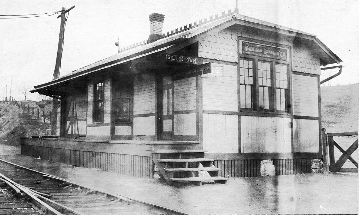
| Gillintown |
 |
|||||||
| Gorton |
|
|||||||
| Graysdale |
|
|||||||
| Greenbriar |
|
|||||||
| Gregg |
|
|||||||
| Gum Stump |
|
This station was on the Snow Shoe Branch of the PRR. It was originally the Bellefonte & Snow Shoe RR which ended its independent operation in January 1881, when it was sold to the Bald Eagle Valley Railroad, long a subsidiary of the PRR. The Bellefonte & Snow Shoe and the Moshannon Railroads were merged into the Bald Eagle Valley in 1881 to become the Snow Shoe Branch. | ||||||
| Hannah (Hannah Furnace) |
|
In 1874 this station was on the NE side of CR-3025 on the SE side of the tracks at GPS: 40.766293, -78.095822. This location was also known as Buddville. | ||||||
| Hecla Park |
|
|||||||
| Hostler |
|
According to PRR valuation records, there was no station or shelter here, only a sign so it may have been a flagstop. Hostler was between Marengo and Pennsylvania Furnace. | ||||||
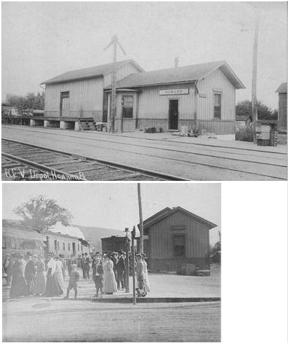
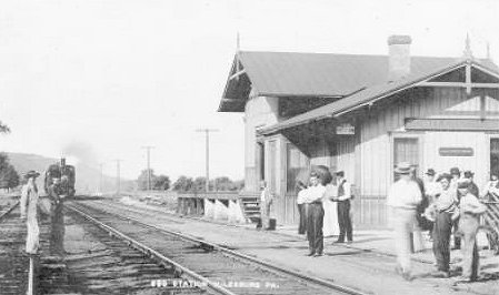
| Howard |
|
In 1874 there was a passenger and a freight station on the south side of Walnut Street on the west side of the tracks at GPS: 41.014074, -77.658329. The 1874 map shows the freight and passenger stations are separate buildings, so that may or may not be the station in the photo. | ||||||
| Hublersburg |
|
|||||||
| Hunters Park |
|
This was the location of an amusement park built by the railroad. | ||||||
| Huston |
|
|||||||
| Ingleby |
|
This town no longer exists. It was NW of Poe Paddy State Park. | ||||||
| Julian (Julian Furnace) |
|
In 1874 the station was on the north side of the tracks near where Furnace Street intersected with Railroad Street at GPS: 40.864854, -77.939255. | ||||||
| Juniata Mines |
|
There may have been a station at the mines at the end of the Juniata Branch at Tow Hill. | ||||||
| Kato |
|
|||||||
| Krumrine |
|
|||||||
| Lagarde (Alto) |
|
|||||||
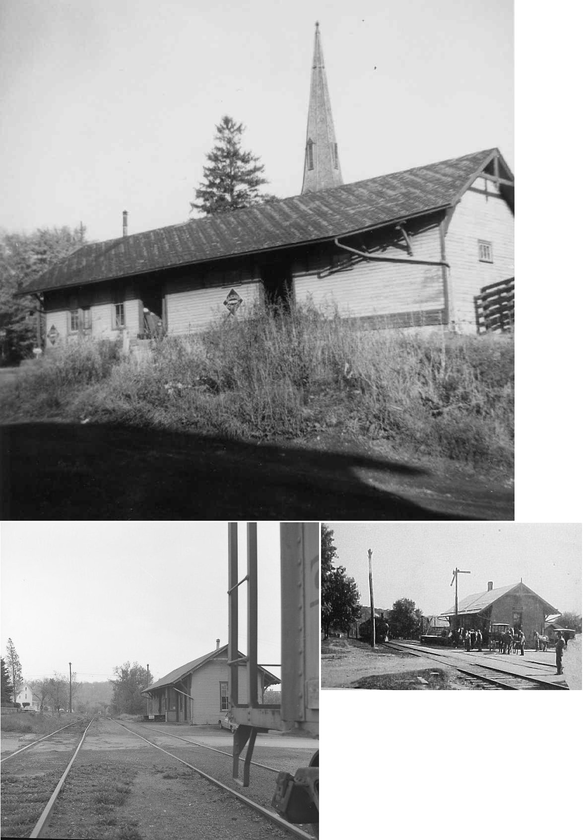
| Lemont |
|
This station was at 140 Mary Street (GPS: 40.809301, -77.817686). The PRR built this wood station on its Lewisburg & Tyrone Branch in 1885. Its telegraph call sign was MN. It was the PRR's principal passenger and freight station for Penn State and the surrounding community of State College, about three miles distant. Passenger service was discontinued September 24, 1949. Track was pulled up east of Lemont after Hurricane Agnes caused serious washouts in June 1972, but freight continued to be consigned to Lemont itself until about 1980. The building then fell into disrepair and suffered several fires caused by vandals. A new building was constructed on the site in 1991 to resemble a station. | ||||||
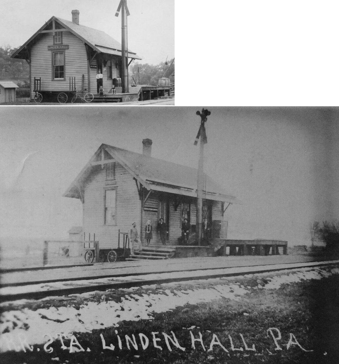
| Linden Hall |
|
This station was built in 1885. | ||||||
| Linns |
|
|||||||
| Lower Gum Stump |
|
|||||||
| Marengo |
|
According to PRR valuation records a new station was built here in 1883. | ||||||
| Martha Furnace (Martha) |
|
A new station was built here in 1884. | ||||||
| Mattern Junction |
|
|||||||
| Milesburg |
|
This station was between the Bald Eagle Valley tracks and the Bellefonte tracks between Depot Street and Railroad Street at GPS: 40.944104, -77.793532. | ||||||
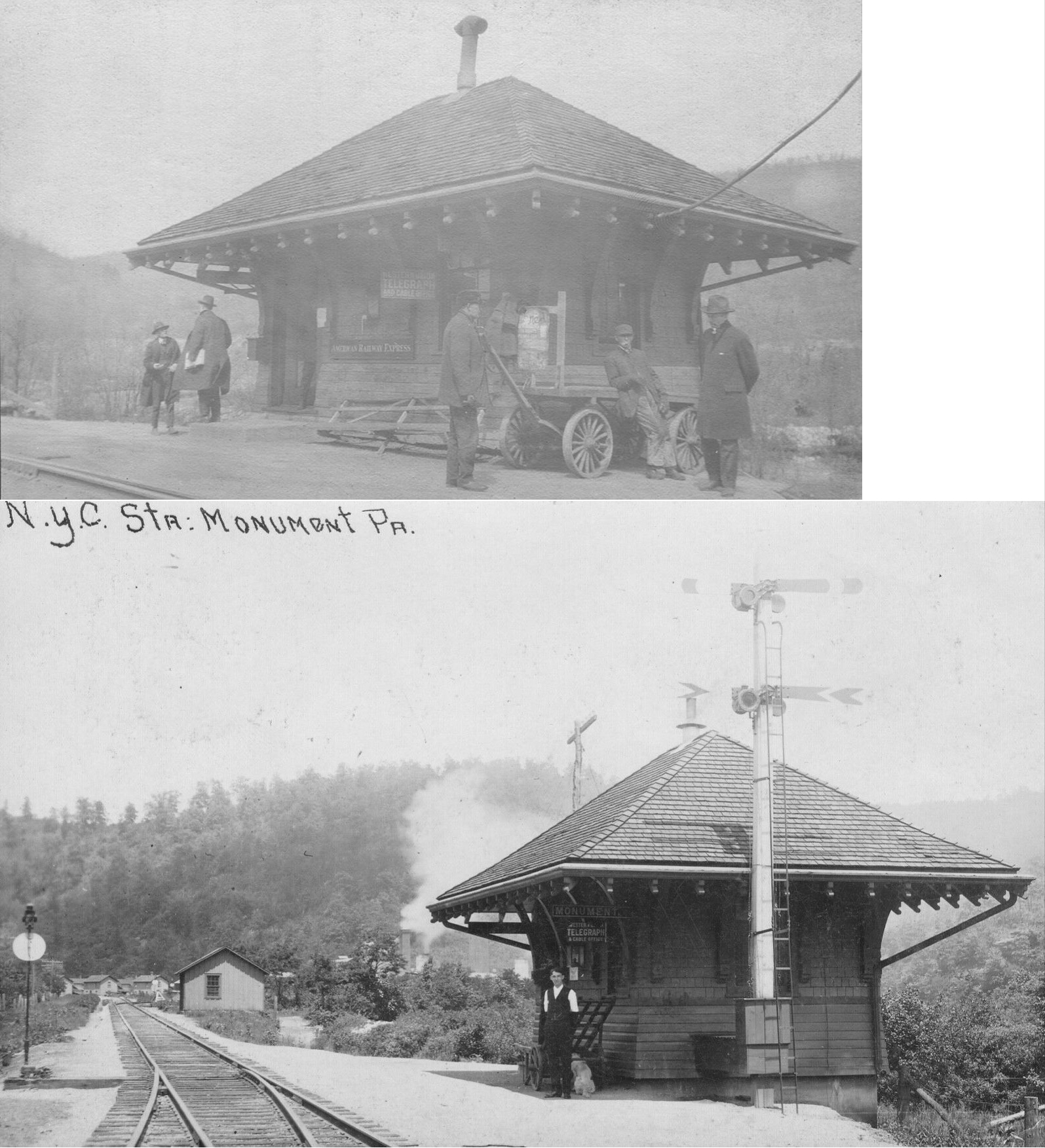
| Monument |
|
Passenger station. | ||||||
| Monument |
|
Freight house. | ||||||
| Morris |
|
|||||||
| Moshannon (Per Se) |
|
This station was on the Snow Shoe Branch of the PRR. It was originally on the old Moshannon RR. | ||||||
| Mount Eagle |
|
|||||||
| Mount Pleasant |
|
|||||||
| Musser |
|
According to PRR valuation records, there was no station or shelter here, only a sign so it may have been a flagstop. The 1900 PRR List of Stations & Sidings indicate that it was a station, but was denoted as a flagstop. Musser was between Scotia and Fairbrook. | ||||||
| Nigh |
|
|||||||
| Nittany |
|
|||||||
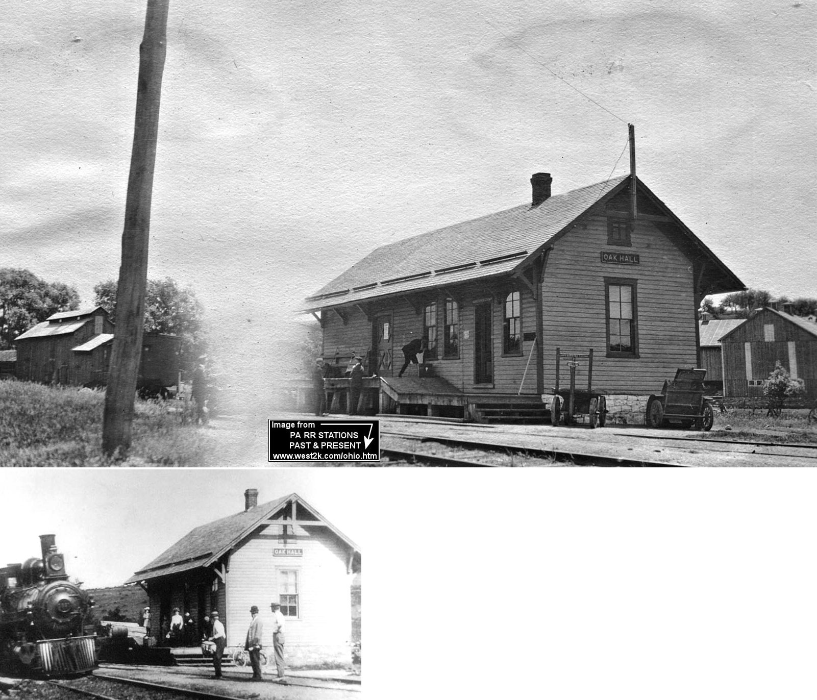
| Oak Hall |
|
|||||||
| Old Fort |
|
|||||||
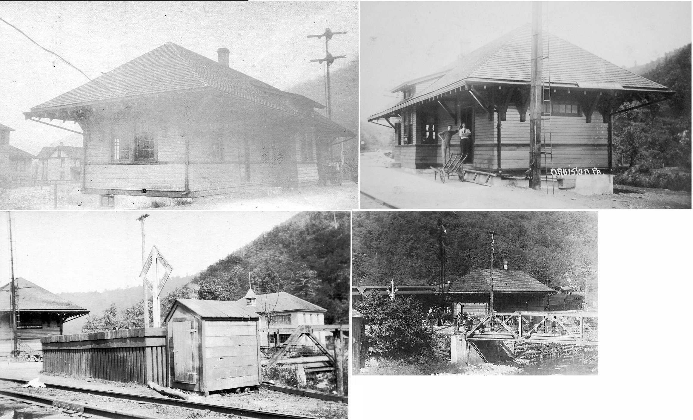
| Orviston |
|
This combination station was just west of the church, across Beech Creek Stream, and just north of Main Street. Passenger service was discontinued in 1933 with the line being torn out in the 1960s. | ||||||
| Osceola Station |
|
|||||||
| Paddy Mountain |
|
|||||||
| Panther |
|
|||||||
| Peru |
|
|||||||
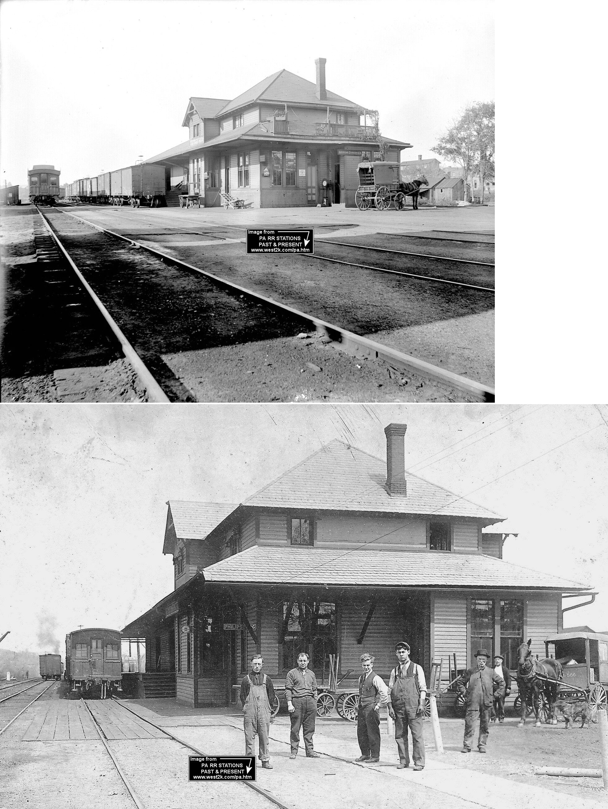
| Philipsburg (Chester HIll) |
AND  |
The NYC/Beech Creek Railroad's "Philipsburg" station was actually in Chester Hill in Clearfield County on the north side of West Presque Isle Street at GPS: 40.895028, -78.225113. The Borough of Philipsburg is across the Moshannon Creek from this station. This was built as a combination type station. The passanger and second floor station master's residence were razed after fire damage. All that remained was the freight shed portion of the building, but that was torn down in the early 2010s (See "Chester Hill" listing on the Clearfield County page). | ||||||
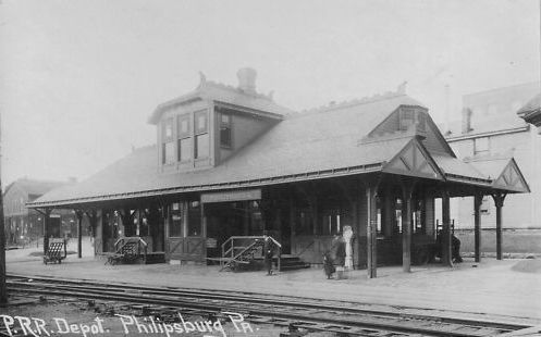
| Philipsburg |
|
The original Tyrone & Clearfield RR passenger station was on the corner of Railroad Street and Presque Isle Street at GPS: 40.895382, -78.223195. This station is shown on the 1887 Sanborn map. A new passenger station was constructed at virtually the same location in 1895. | ||||||
| Philipsburg |
|
There was a Tyrone & Clearfield RR freight station on the east side of the tracks between West Spruce Street and West Locust Street west of North Front Street at GPS: 40.897977, -78.225374. This station is shown on the all maps from 1874-1910. | ||||||
| Pine Grove mIlls |
|
This station was on the north side of West Pine Grove Road at GPS: 40.7333259, -77.8906068. | ||||||
| Pleasant Gap |
|
|||||||
| Plum Grove |
|
|||||||
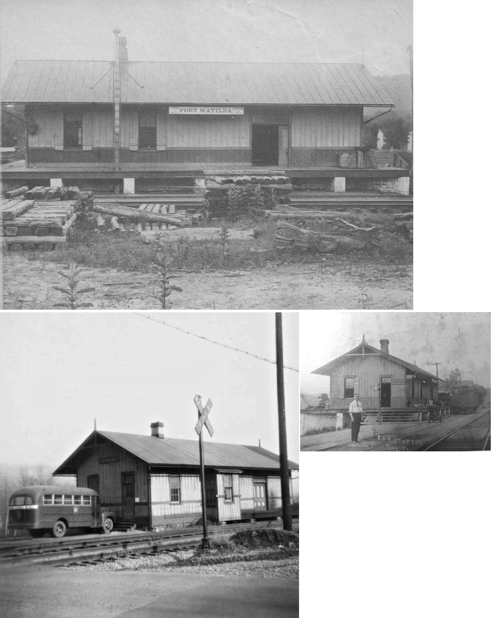
| Port Matilda |
|
In 1874 the station was on the NE side of High Street on the NW side of the tracks at approximately GPS: 40.797719, -78.051166. | ||||||
| Port Matilda |
|
|||||||
| Powelton |
|
|||||||
| Red Bank |
|
Not to be confused with Red Bank in Clarion County. This was on the BCRR's Red Bank Branch which was a short-lived (1887-1896) branch to serve an ore mine. Red Bank was somewhere south of Stormstown near The Barrens. | ||||||
| Retort |
|
|||||||
| Rhodes (Summit) |
|
This station was originally called "Summit," but the name was changed by the PRR in 1881 to "Rhodes." | ||||||
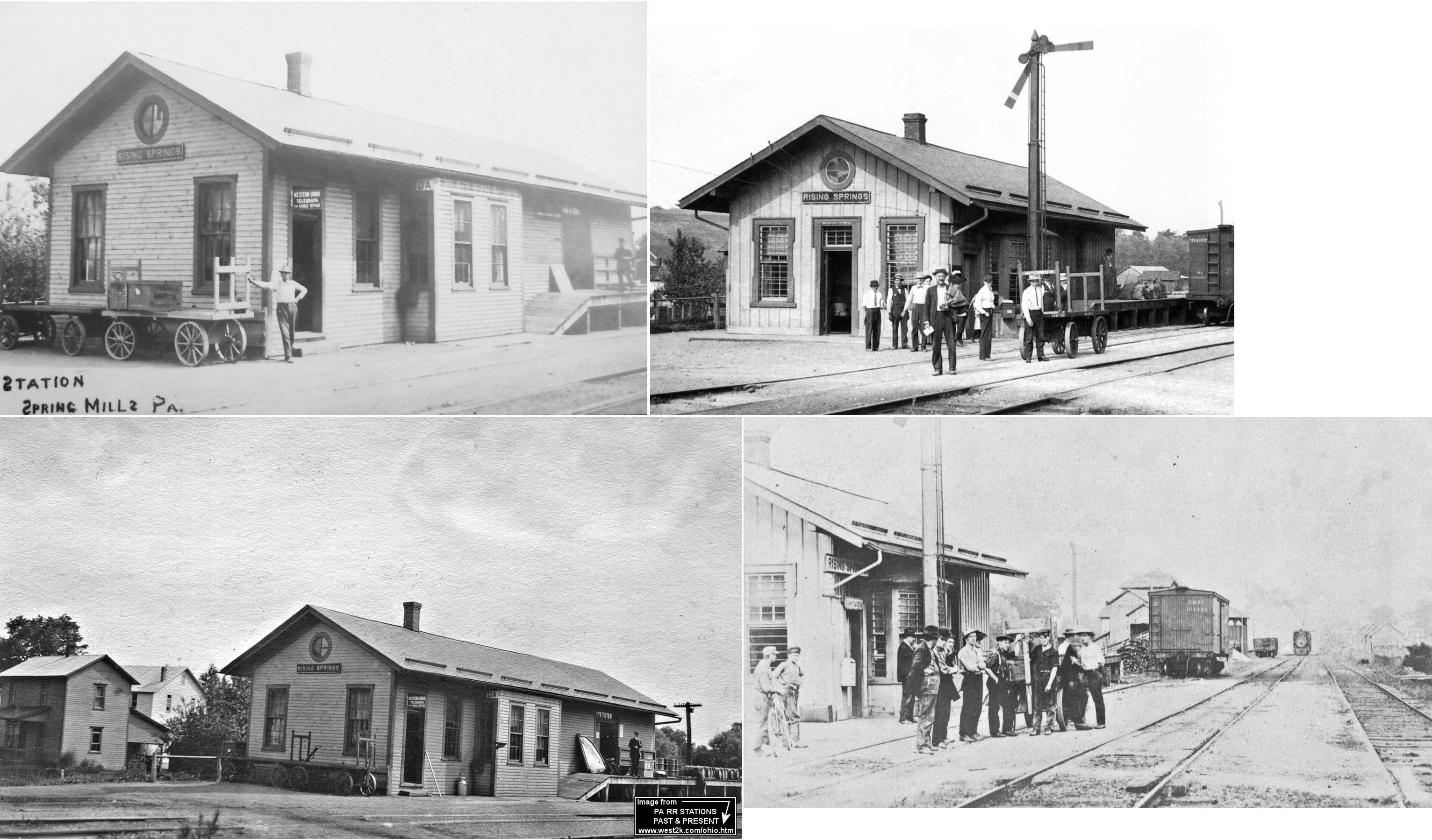
|
Rising Springs (Spring Mills) |
|
This town was east of Centre Hall. | ||||||
| Sandy Ridge |
|
This station was on what is now Brickyard Lane on the NE side of the tracks at approximately GPS: 40.808985, -78.227167. | ||||||
| Scotia |
|
A new combination station was built here in 1882-1883. | ||||||
| Scotia |
|
|||||||
| School House |
|
|||||||
| Sellers |
|
|||||||
| Snow Shoe (Clarence) |
|
|||||||
| Snow Shoe |
|
This combination station was on the Snow Shoe Branch of the PRR. It was in the middle of Moshannon Street as the tracks (where Railroad Street is now) ran NE along the west side of that street. The station was at approximately GPS: 41.030072, -77.947701. | ||||||
| Snow Shoe Intersection |
|
|||||||
| Spring Mills |
|
See listing above for Rising Springs. | ||||||
| State College |
|
This was the original station at State College. | ||||||
| Stevens |
|
|||||||
| Stormstown Station |
|
|||||||
| Struble |
|
|||||||
| Unionville (Fleming) |
|
In 1874 the station was on the NE corner of Main and Apple Street on the north side of the tracks (GPS: 40.905603, -77.875426). A new station was built here in 1884. | ||||||
| Waddle |
|
|||||||
| Whitmer |
|
|||||||
| Wingate |
|
|||||||
| Worth |
|
The 1900 PRR timetable lists a freight station at this location. It was between Port Matilda and Martha. | ||||||
| Zerby |
|
|||||||
| Zion |
|
|||||||
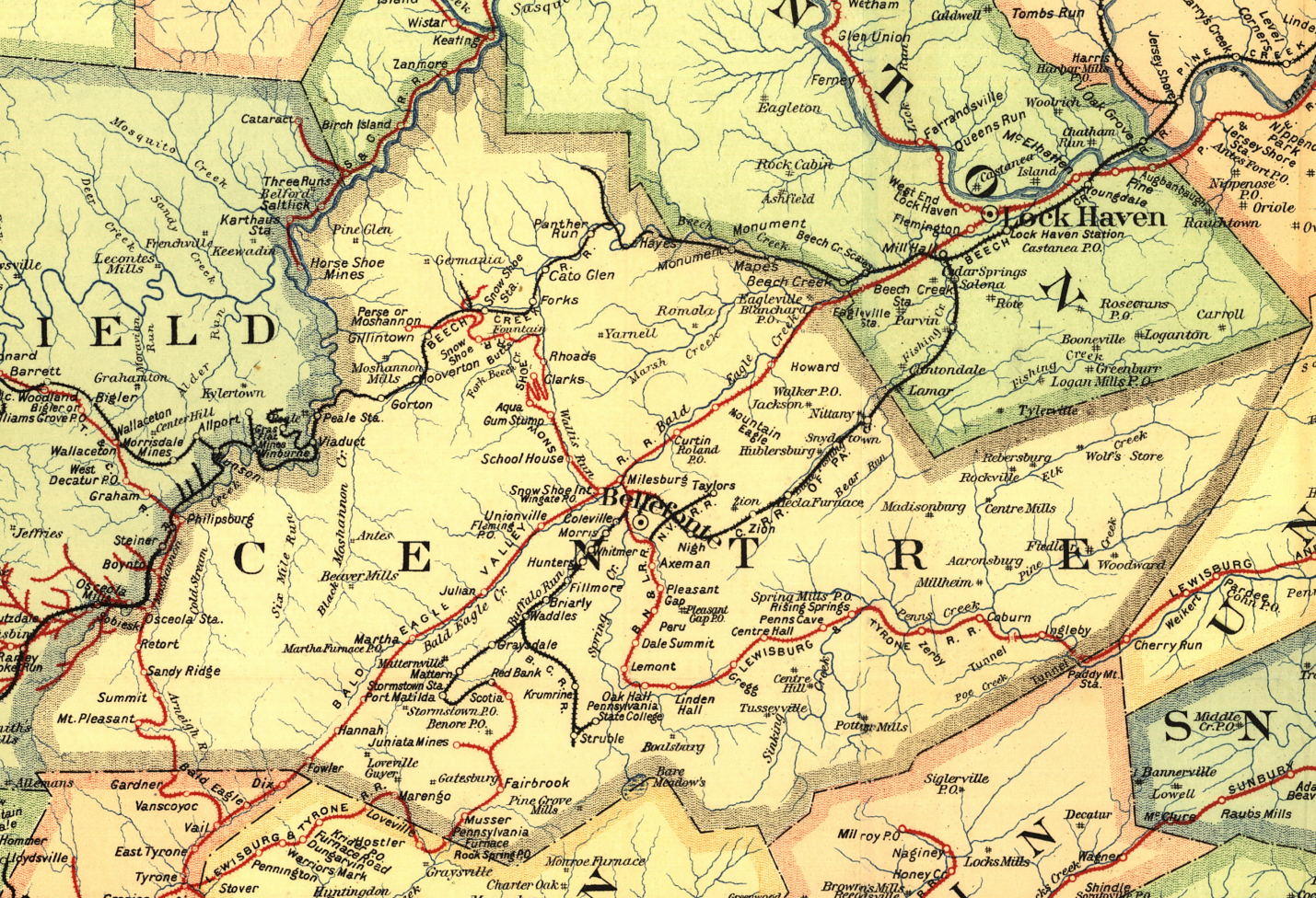
| 1895 CENTRE COUNTY RAILROAD MAP | ||||||||
 |
||||||||
| Notes About Existing
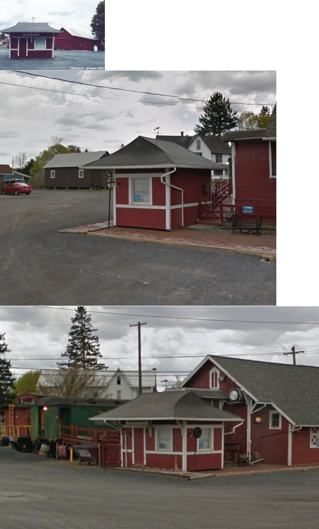
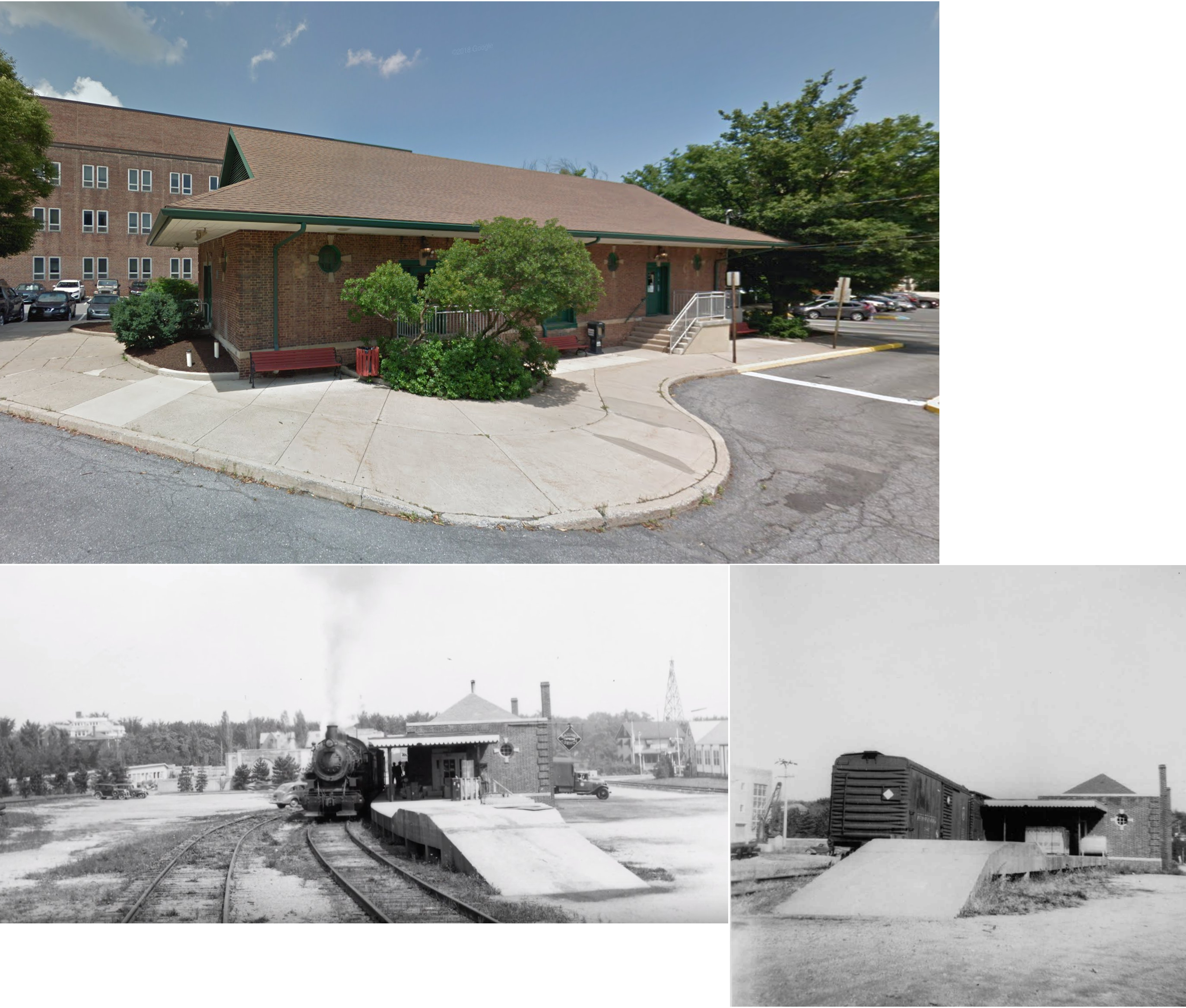
Stations... Bellefonte (Bald Eagle Valley/Bellefonte Central) - HQ of Bellefonte Historical RR. See photo here. The Bald Eagle Valley RR/PRR opened this brick station, telegraph call sign BF, for passenger and express service on February 11, 1889. The freight station (razed around 1970) was about 1,000 feet further north. Originally the passenger tracks were on the east side, between the station and Spring Creek, but these were taken up in the early 1900s. The Bellefonte Central also used this station for its passenger service to and from State College until this service was discontinued in March 1946. PRR passenger service ended August 23, 1950. In the early 1980s, the Bellefonte Chamber of Commerce purchased the station and refurbished it for its offices. The chamber rents space to the Bellefonte Historical Railroad, which has a ticket office here for its weekend Rail Diesel Car excursions. --Note by Michael Bezilla Centre Hall (PRR) - The PRR built this wood station, telegraph call sign RH, located along Pennsylvania Avenue (Pa. Route 144), in 1884 on its Lewisburg & Tyrone Branch. Passenger service was discontinued September 24, 1949. Tracks were pulled up soon after Hurricane Agnes caused washouts along the line in June 1972. Today it houses the Whistle Stop Restaurant, which has local railroad memorabilia on display. Adjacent rolling stock, for future use by the restaurant, includes an Erie coach and a New York Central caboose. --Note by Michael Bezilla Lemont (Replica) - This replica station is on the site of the old Lemont PRR station which was in ruins at the time this was built. In 1991 the site became the location of several retail shops, including Forster's Train Shop, but almost nothing of the original building remains. The Bellefonte Historical Railroad ran Rail Diesel Car excursions from Bellefonte to Lemont from 1992 to 1996. State College (Bellefonte Central) - The Bellefonte Central built the brick State College station on North Atherton Street in 1930 to replace a wooden structure that sat at approximately 101 West College Avenue (now the site of Hammond and Sackett buildings on the Penn State campus). A mixed train from Bellefonte served the station until March 1946. However, occasional passenger specials were operated, including one for President Dwight Eisenhower in 1953. Freight service ended in July 1974 when the BFC abandoned its track to State College. By that time, however, the station had already been leased by local government as a bus terminal, a function that continues today. Station saw heavy traffic during WWI and WWII. There were storage tracks for coal cars which were shunted across the street to the Penn State Power plant where an in-track scale would weigh-in and -out for the delivery. Tracks removed after 1972 Agnes Hurricane (and floods) which damaged some bridges that served the location. Final track ties (and bumper/end-ramp loading platform) removed in late 1980s during parking lot resurfacing. Right-of-way still exists and is paved (or chip) for a bike path, including one deck bridge within 1/2 mile. --Notes by Michael Bezilla & John Balogh |
||||||||