|
|
||||||||
| EXISTING STATIONS | ||||||||
|---|---|---|---|---|---|---|---|---|
| Station Name |
Original Railroad |
Current Location |
Type | Current Use |
Date Built |
Track Status |
Building Material |
More Info |
| Bigler |
 |
South side of Jury Street along Knepp Road (GPS: 40.983846, -78.308873) |
C | Storage | ???? | In Use | Brick | |
| Bigler |
 |
Pinetop Road (PA970) (GPS: 40.985601, -78.310941) |
F | Private | ???? | In Use | Wood | |
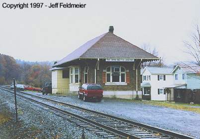
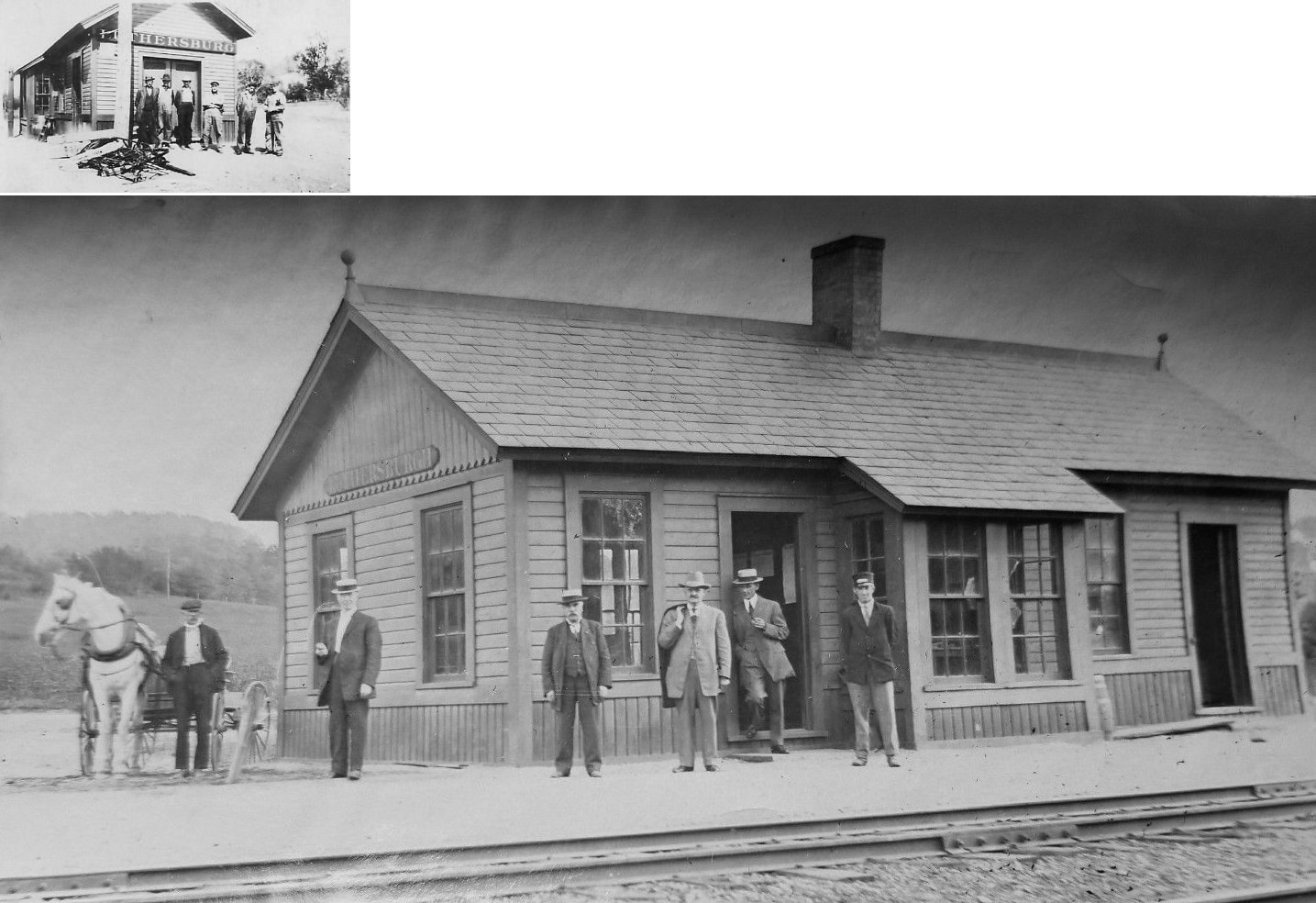
| Brisbin |
|
NW side of Larch Alley south of Swoop Street (GPS: 40.835836, -78.350982) |
C | Private | ???? | None | Wood |
|
| Burnside |
 |
U.S. 219 at First Street (GPS: 40.814143, -78.786408) |
C | Vacant | ???? | In Use | Wood |
|
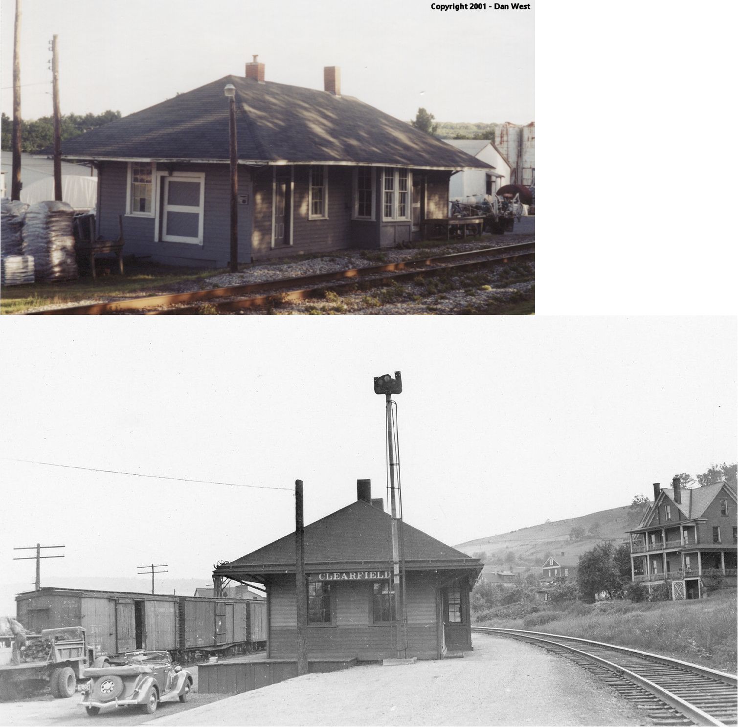
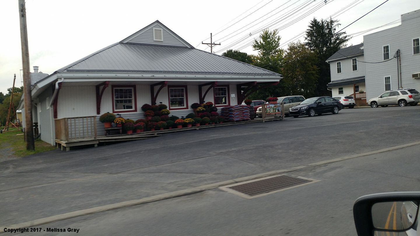
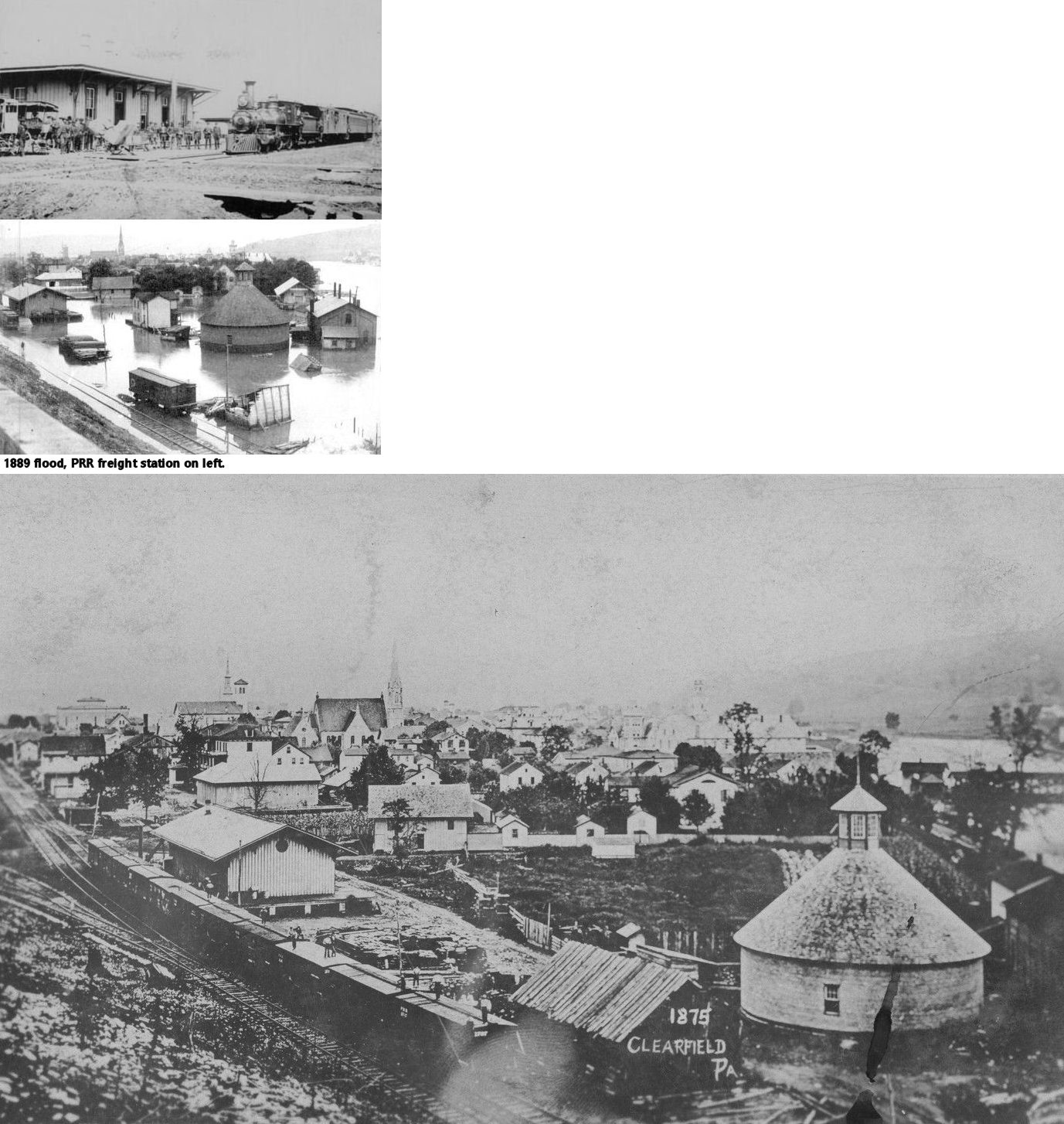
| Clearfield |
 |
Near Market Street & Gulich Street on the west side of town. (GPS: 41.021549,-78.443788) |
P | Business | 1894 | In Use | Wood | |
| Clearfield |
|
Reed & Third Streets near Bridge Street (GPS: 41.025896,-78.436466) |
P | Business | ???? | Gone | Brick/ Stone |
|
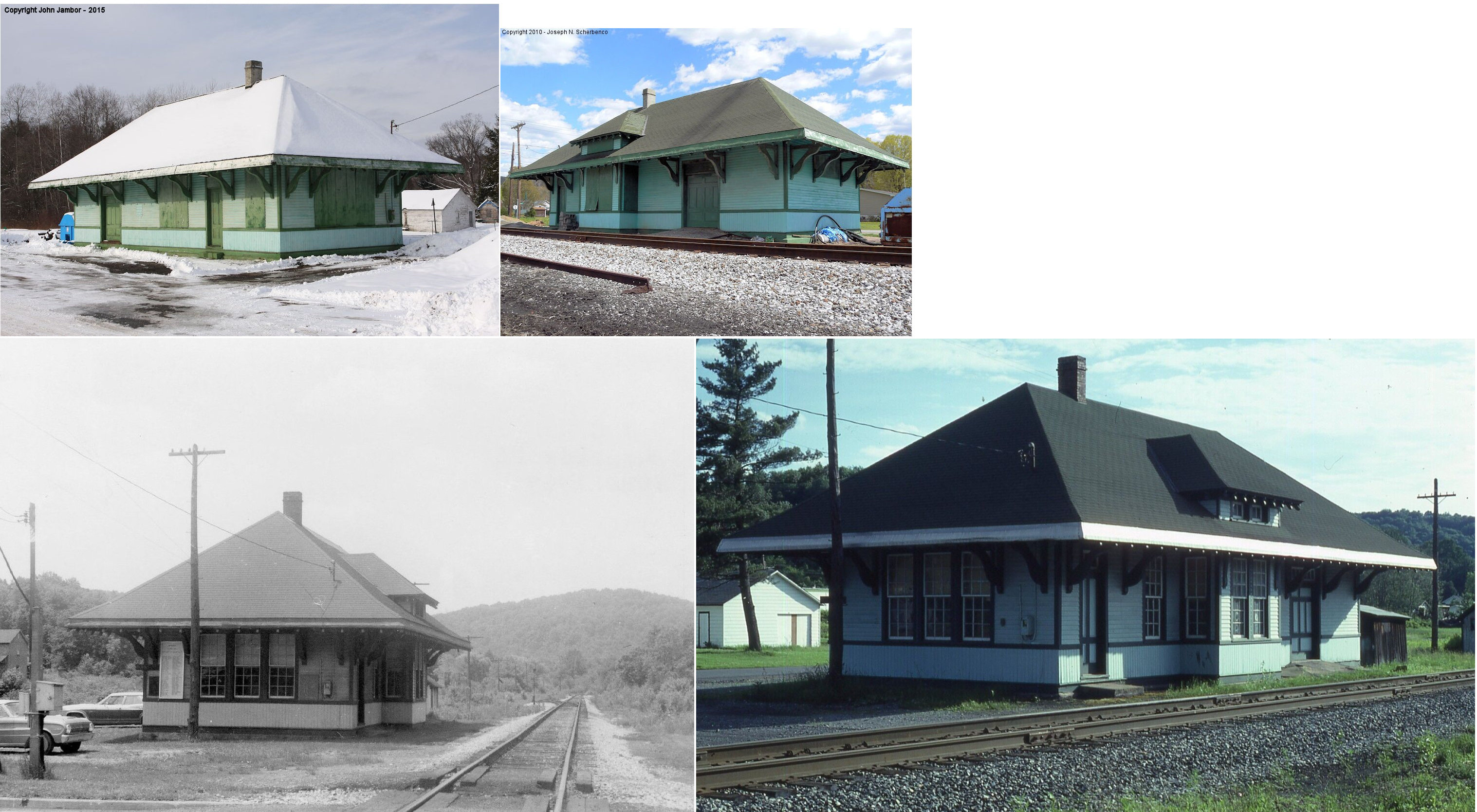
| Curwensville |
|
Meadow & Filbert Streets (GPS: 40.974058,-78.526478) |
P | Business | ???? | Gone | Wood | |
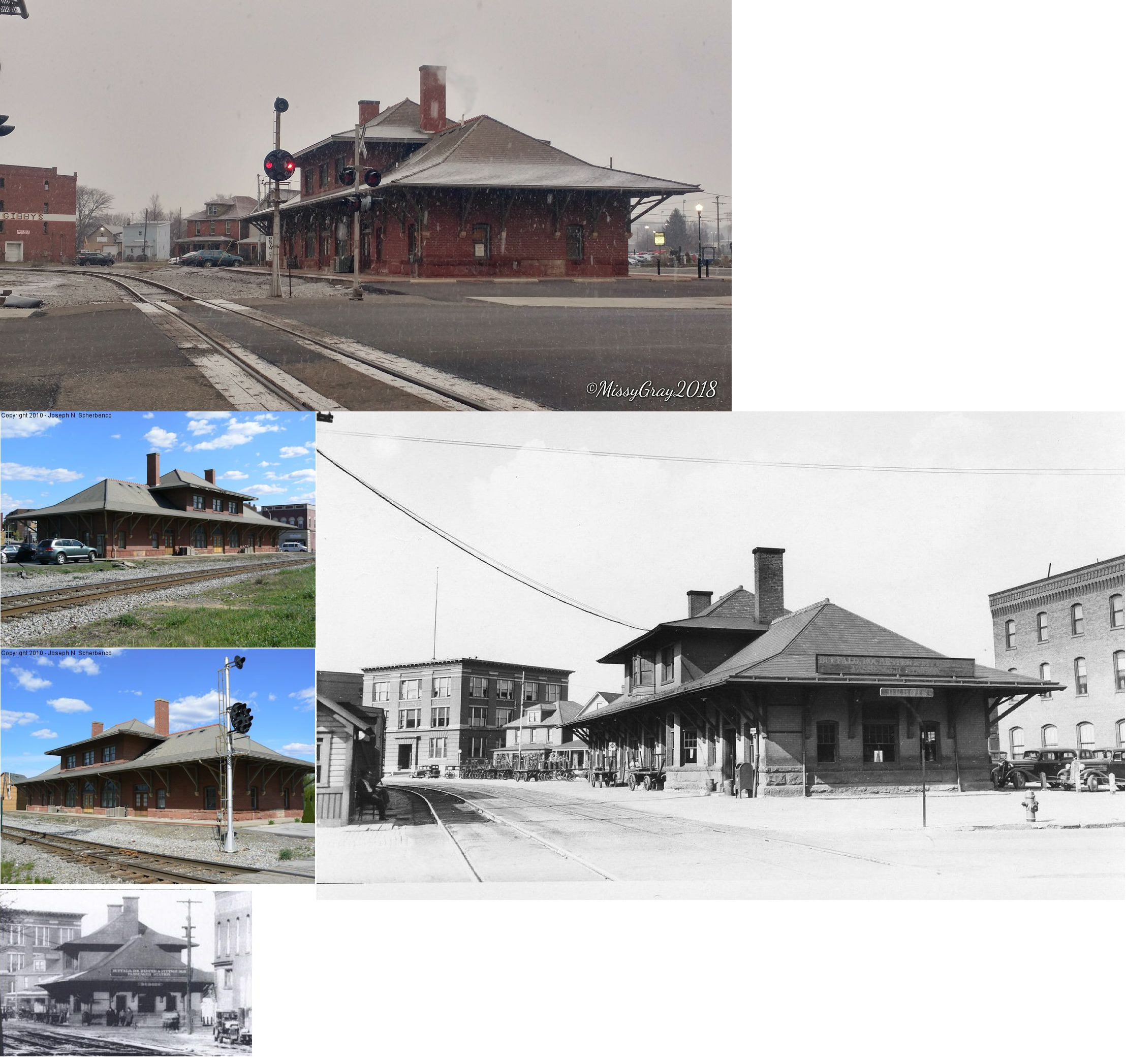
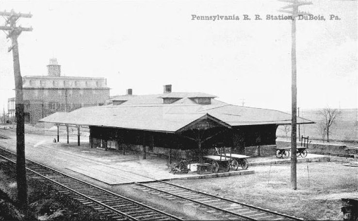
| DuBois |
|
1 North Franklin Street (GPS: 41.121460, -78.765562) |
P | Business | 1894 | In Use | Brick | |
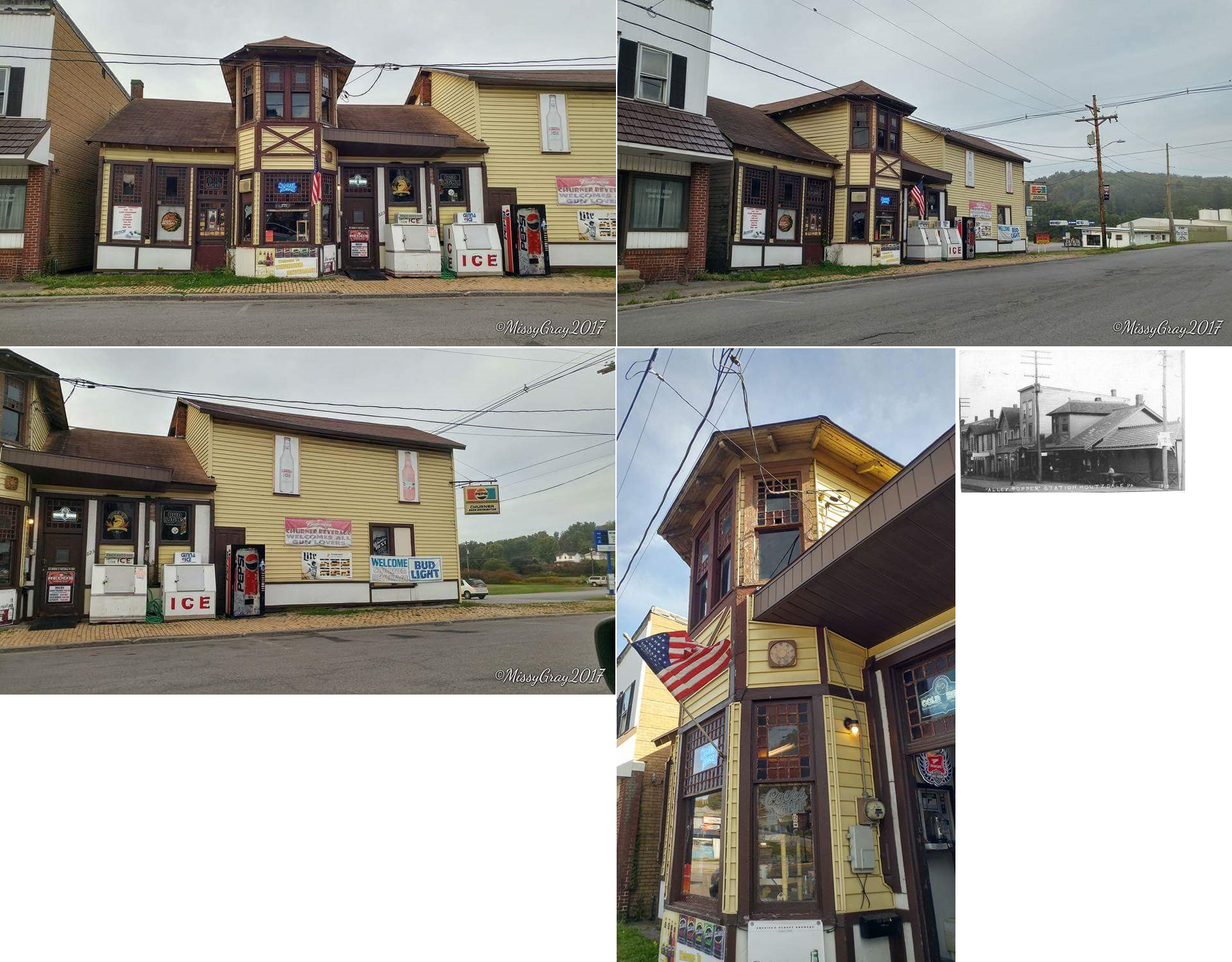
| Houtzdale |
 |
823 Hannah Street (GPS: 40.825164, -78.353858) |
P | Business | ???? | Gone | Wood |
|
| Houtzdale |
|
East side of Brisbin Street south of Hannah Street (GPS: 40.824635, -78.351321) |
C | Storage | 1883 | Gone | Wood | |
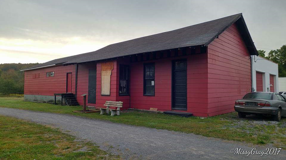
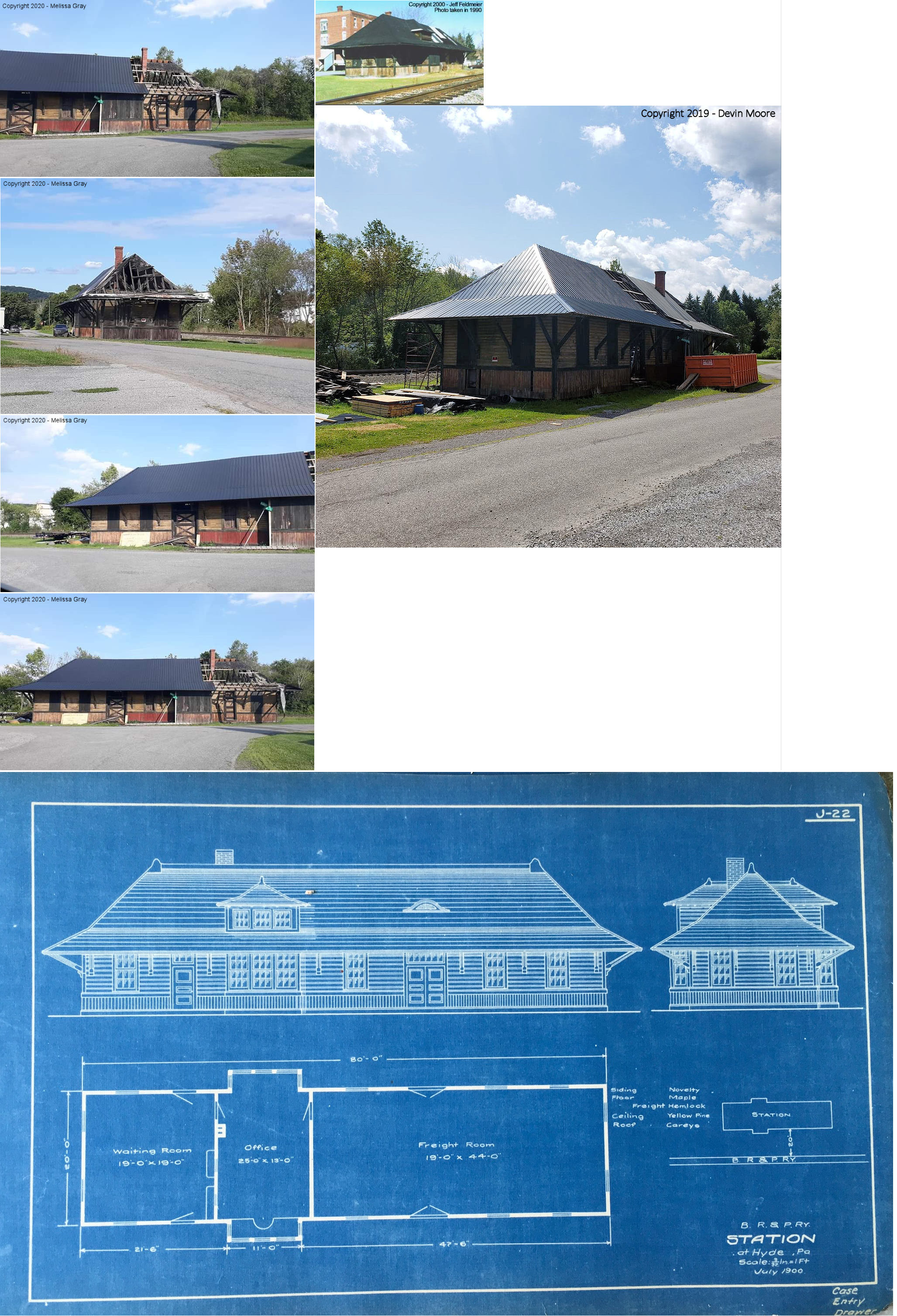
| Hyde (Center) |
|
Susquehanna Street at Hoover Street (GPS: 40.999477, -78.463488) |
C | Storage | 1903 | In Use | Wood | |
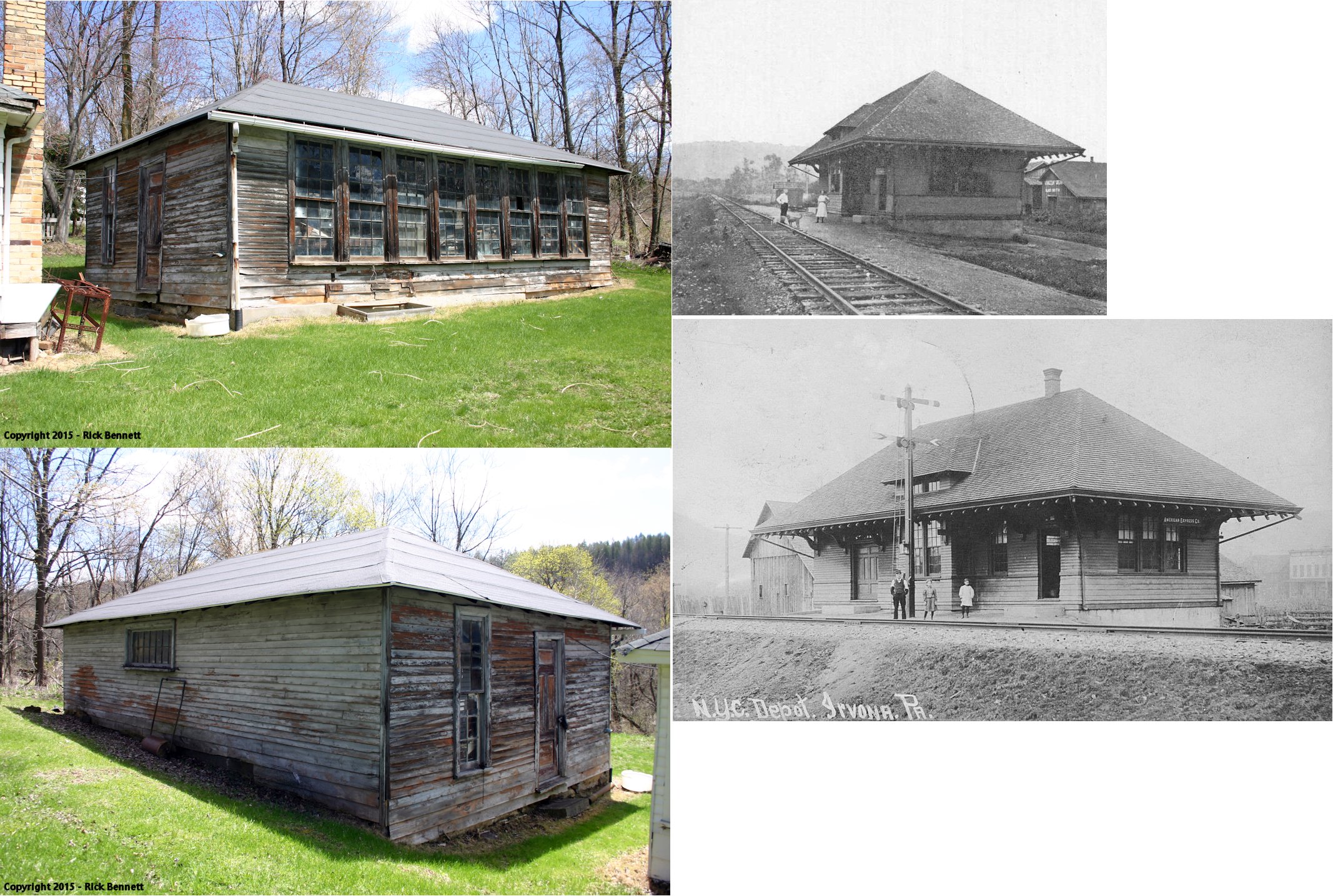
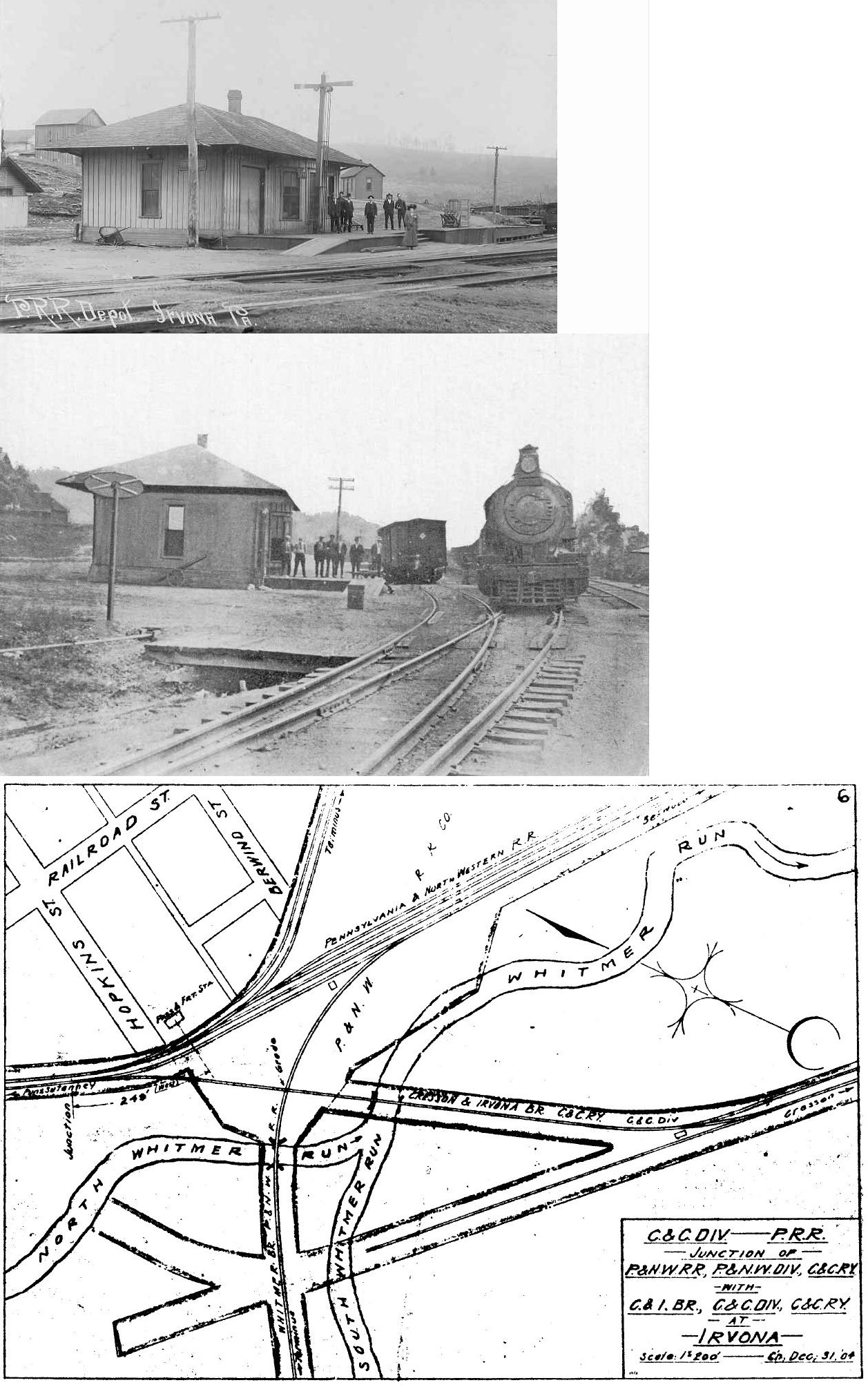
| Irvona |
 |
Moved from Irvona and rebuilt in Blain City in a backyard on Locust Street (GPS: 40.756512, -78.529376) |
C | ???? | 1904 | None | Wood |
|
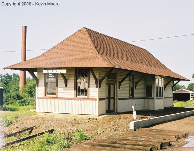
| Rockton |
|
321 Biddle Street (US-6), Kane (GPS: 41.659369, -78.804162) |
P | Railroad | 1898 | In Use | Wood |
|
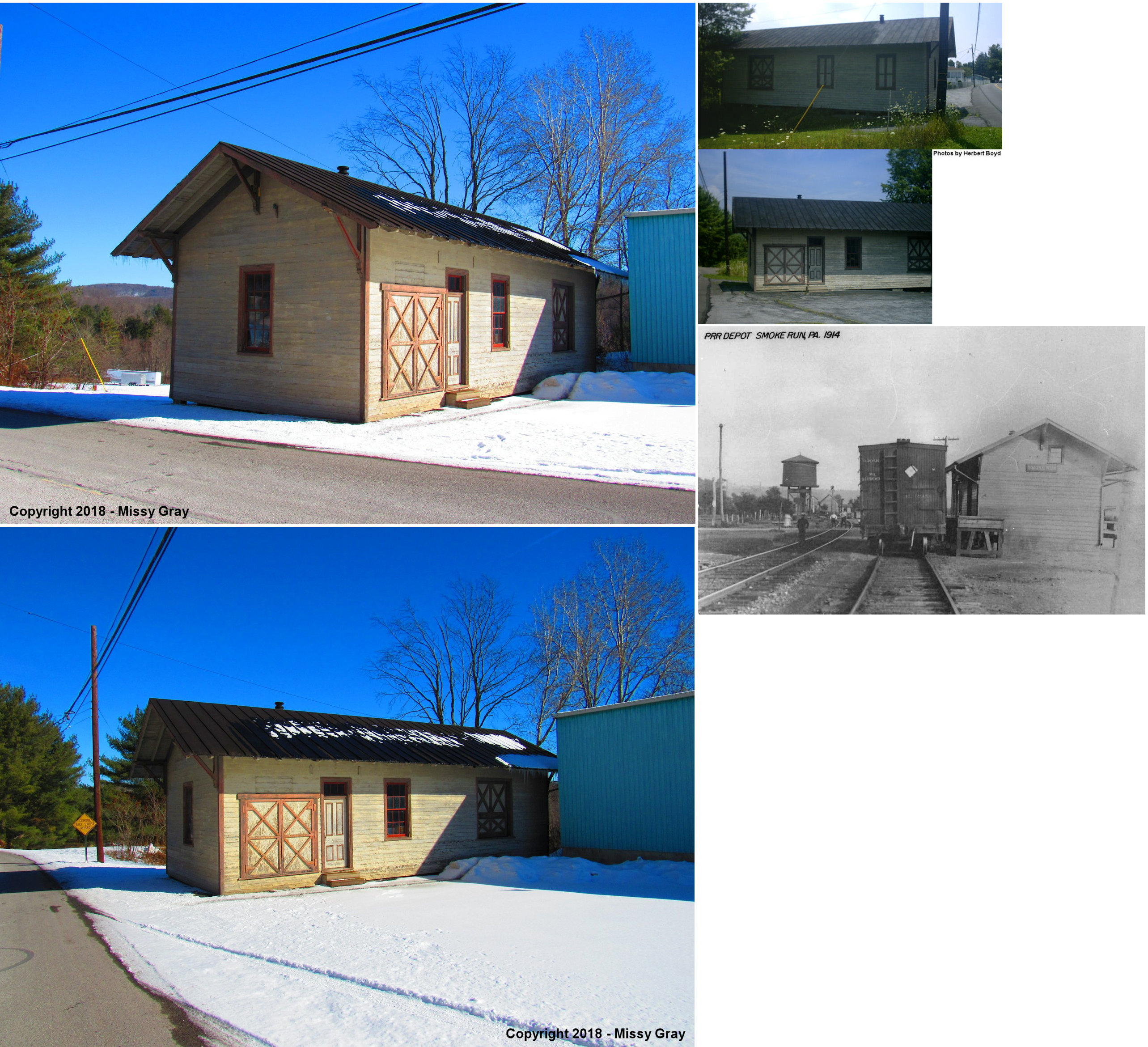
| Smoke Run |
|
One mile South of former location on Crossroads Boulevard at Jones Salvage (GPS: 40.788748, -78.432961) |
C | Storage | 1895 | None | Wood |
|
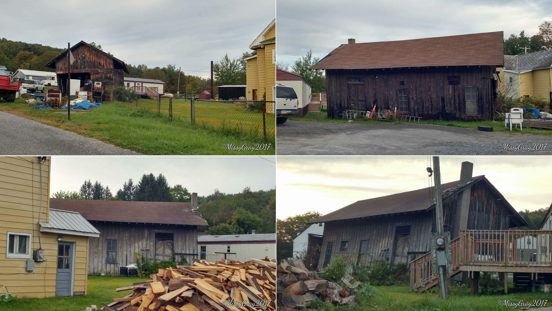
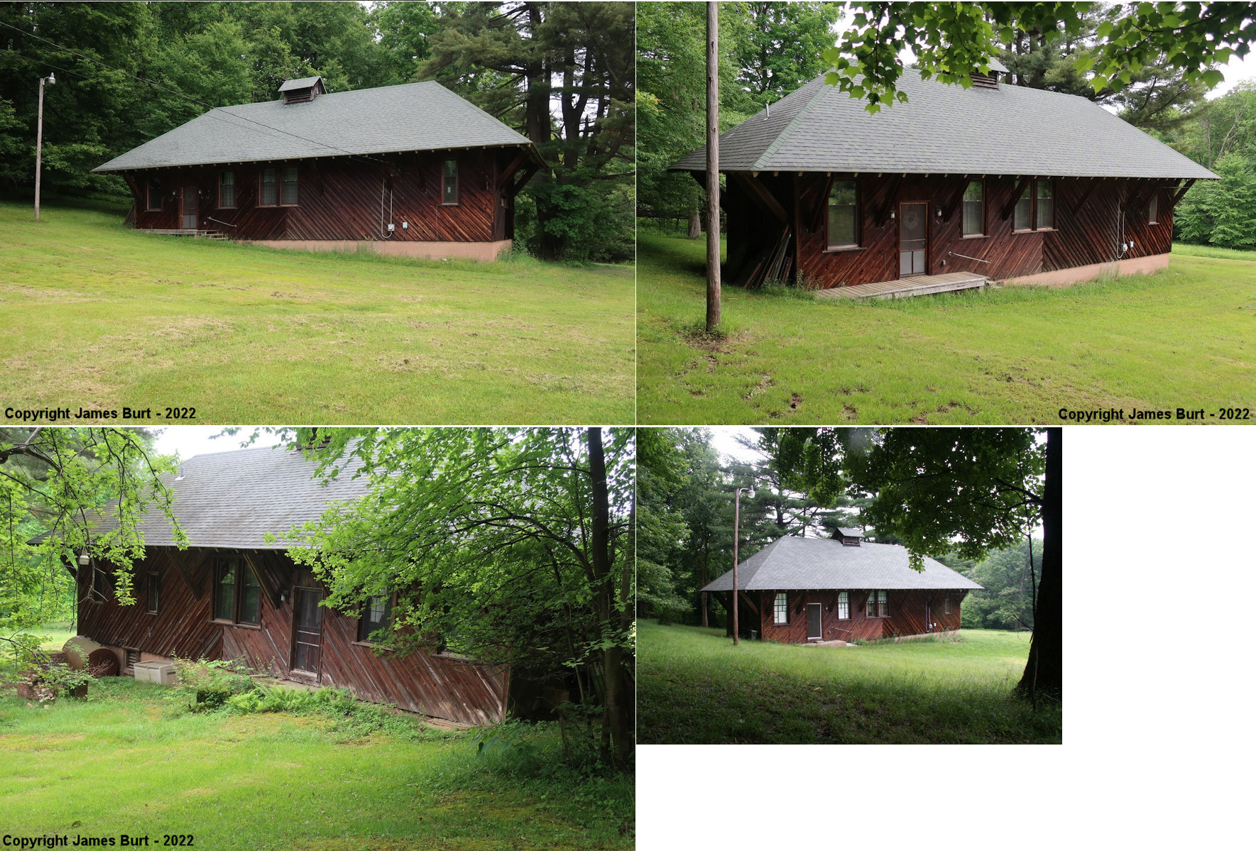
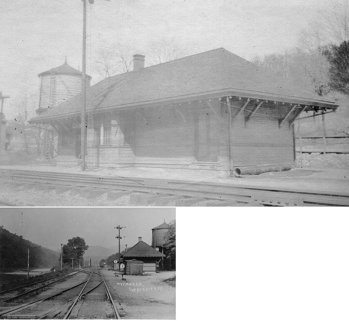
| Lumber City? |
|
1143 Splash Dam Road at Curry Run Road, NW of Curry Run (GPS: 40.955300, -78.714200) |
C | Residence | ???? | None | Wood |
|
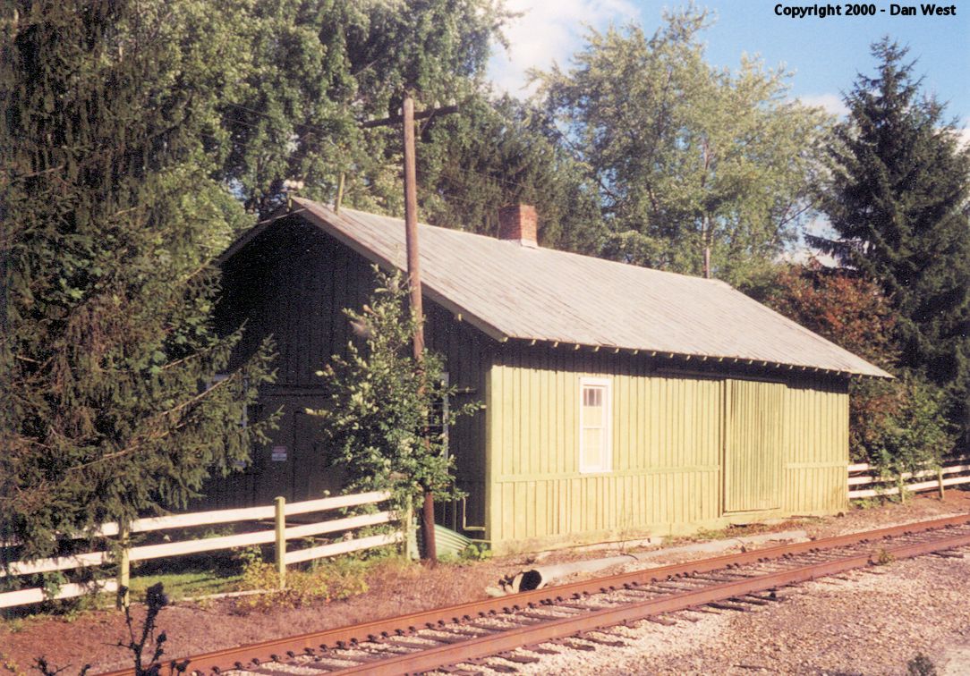
| Winterburn |
 |
444 Winterburn Road, Pennfield (GPS: 41.178955, -78.604437) |
F | Cabin | ???? | None | Wood |
|
| STATIONS OF THE PAST | ||||||||
| Station Name |
Original Railroad |
Notes | ||||||
| Almaden |
|
This station was on the the Little Muddy Run Branch. It was on the north side of Tipple Road at approximately GPS: 40.760839, -78.399086. | ||||||
| Anderson |
|
This station was between Glendale and Rockton. | ||||||
| Bald Hill |
|
This was on the West Branch Valley Branch. This was a small enclosed shelter-type station. | ||||||
| Banian junction |
|
This station was west of Banian Road in the vicinity of GPS: 40.813781, -78.436499. | ||||||
| Beccaria |
|
This station was on the SW side of Veterans Street (PA729) at approximately GPS: 40.769402, -78.448027. | ||||||
| Belford |
|
This was on the West Branch Valley Branch. The depot was on Tipple Road at approximately GPS: 41.127747, -78.079691. | ||||||
| Bells Landing |
|
This was a small enclosed shelter-type station. | ||||||
| Bellnap Station |
|
This station was on the east side of U.S. 219 near the intersection of Baird Lane where Martin run empties into the West Branch of the Susquehanna at approximately GPS: 40.849074, -78.785976. | ||||||
| Belsena |
|
A new station was built here in 1887. | ||||||
| Berwindale |
|
This was on the PRR's Mayes Branch. It was near the intersection of Irvona Road and Frailey Road at approximately GPS: 40.816963, -78.593814. | ||||||
| Beulah |
|
This station was on the east side of PA453 (Union Street) at approximately GPS: 40.804778, -78.404978. It was on the Moshannon Branch and was abandoned by the PRR in 1911 (Altoona Tribune, 11-03-1911). | ||||||
| Blain City |
|
|||||||
| Bloom (Blooms Run) |
|
This station was between Glendale and Bridgeport. | ||||||
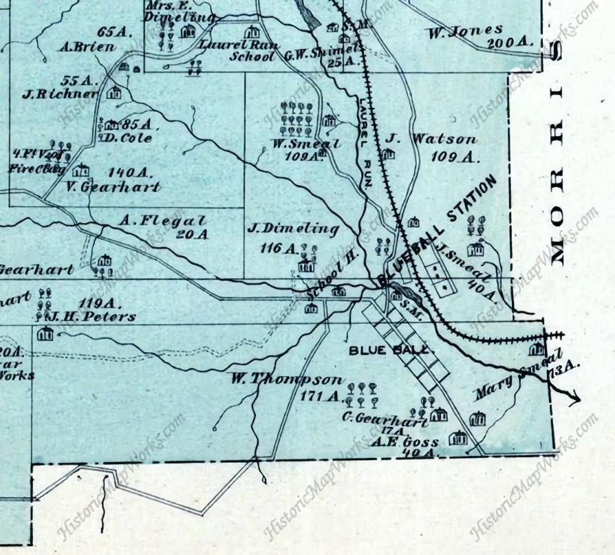
| Blue Ball (W. Decatur) |
|
The freight station was on the SE side of Hilltop Road on the SW side of the tracks at GPS: 40.931438, -78.278859. The passenger station was further down the tracks to the SE at approximately GPS: 40.931009, -78.278562. | ||||||
| Boardman |
|
This was on the Boardman Branch, formerly the Clearfield Southern mainline. | ||||||
| Bower |
|
This station was on the NE side of Camp Corbly Road at approximately GPS: 40.894950, -78.675823. | ||||||
| Bridgeport |
|
This station was on the NE side of Greenville Pike at approximately GPS: 40.978874, -78.549931. | ||||||
| C&M Junction |
|
|||||||
| Cataract |
|
There was a freight station here. | ||||||
| Centre |
|
This station was between Wrights and Clearfield. | ||||||
| Chase |
|
This was on the Clearfield Southern Branch south of Lambert and north of Faunce. | ||||||
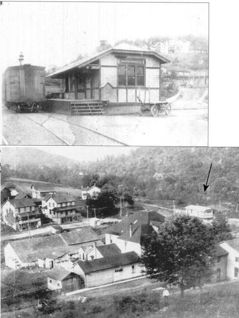
| Chester Hill (Philipsburg) |
|
This combination station was on Presque Isle Street at Moshannon Creek (GPS: 40.895028, -78.225113). This was the NYC/Beech Creek Railroad's "Philipsburg" station. The Borough of Philipsburg is actually across the Moshannon Creek from this station. This was built originally as a combination type station, but served as a freight station in later years. The passanger and second floor station master's residence were razed after fire damage. All that remained was the freight shed portion of the building. The station was used for storage by JJ Powell Oil Company until it was razed sometime around 2011-2014. Does anyone know the fate of the station? | ||||||
|
Chester Hill (Steiner's) |
|
The Steiner's Station Tyrone & Clearfield depot is shown here on the 1878 map and also on the 1910 Sanborn map. It was located on the NW side of the tracks at the Phillipsburg Fire Brick Company. There are no streets in this area now, but the station was at approximately GPS: 40.888172, -78.226112. This is past the SE end of Laura Street in Chester Hill. However, the 1917 map puts the station past the SE end of Gertrude Street at 40.889206, -78.224975. That location is probably more accurate. | ||||||
|
Chester Hill (Weighton) |
|
This station was just a few yards to the north of the PRR station listed above. It was on the north side of the tracks at the end of Gertrude Street at GPS: 40.889413, -78.225048. This is shown on the 1917 Sanborn map as a Pittsburgh & Susquehanna (previously the Altoona & Philipsburg RR)station. | ||||||
|
Chesterfield (Ventland) |
|
Ventland was the name of the town/post office, but the station there was called "Chesterfield" by the railroad. This was on the 2.5-mile Banian Branch of the PRR. The Banian Branch came off the Moshannon Branch north of Smoke Run. The town/station was in the general vicinity of GPS: 40.794170, -78.466200. The station was abandoned by the PRR in 1911 (Altoona Tribune, 11-03-1911). | ||||||
| Clearfield |
|
There was a freight station on the south side of the exisiting station near Market and Gulich Streets at GPS: 41.021390, -78.443929. | ||||||
| Clearfield |
|
This Tyrone & Clearfield station was located on the corner of Reed and Third Streets (GPS: 41.025674, -78.436500) and is a predecessor to the station that currently exists. | ||||||
| Clearfield |
|
There was a freight station on Third Street to the north of Bridge Street at approximately GPS: 41.027047, -78.436453. | ||||||
| Clearfield |
|
This combination station was on North 2nd Street north of Bridge Street (GPS: 41.027159,-78.437641). | ||||||
| Clearfield Junction |
|
|||||||
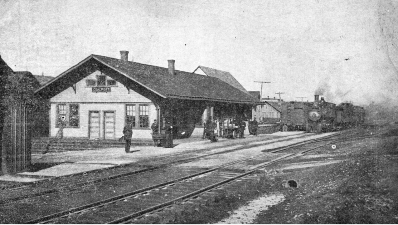
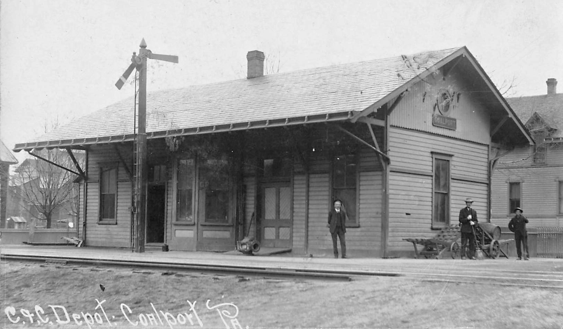
| Coalport |
|
This station was on the corner of Pine and Railroad Streets at GPS: 40.746661, -78.533916. | ||||||
| Coalport |
|
This station was on the corner of Pine and Union Streets at GPS: 40.746237, -78.535897. | ||||||
| Coal Run Junction |
|
This station was east of the intersection of Coal Run Road and PA53 where the Coal Run Branch diverges at GPS: 40.849558, -78.292134. | ||||||
| Curry Run |
|
This station was on the east side of Zorger Road at approximately GPS: 40.908572, -78.664964. | ||||||
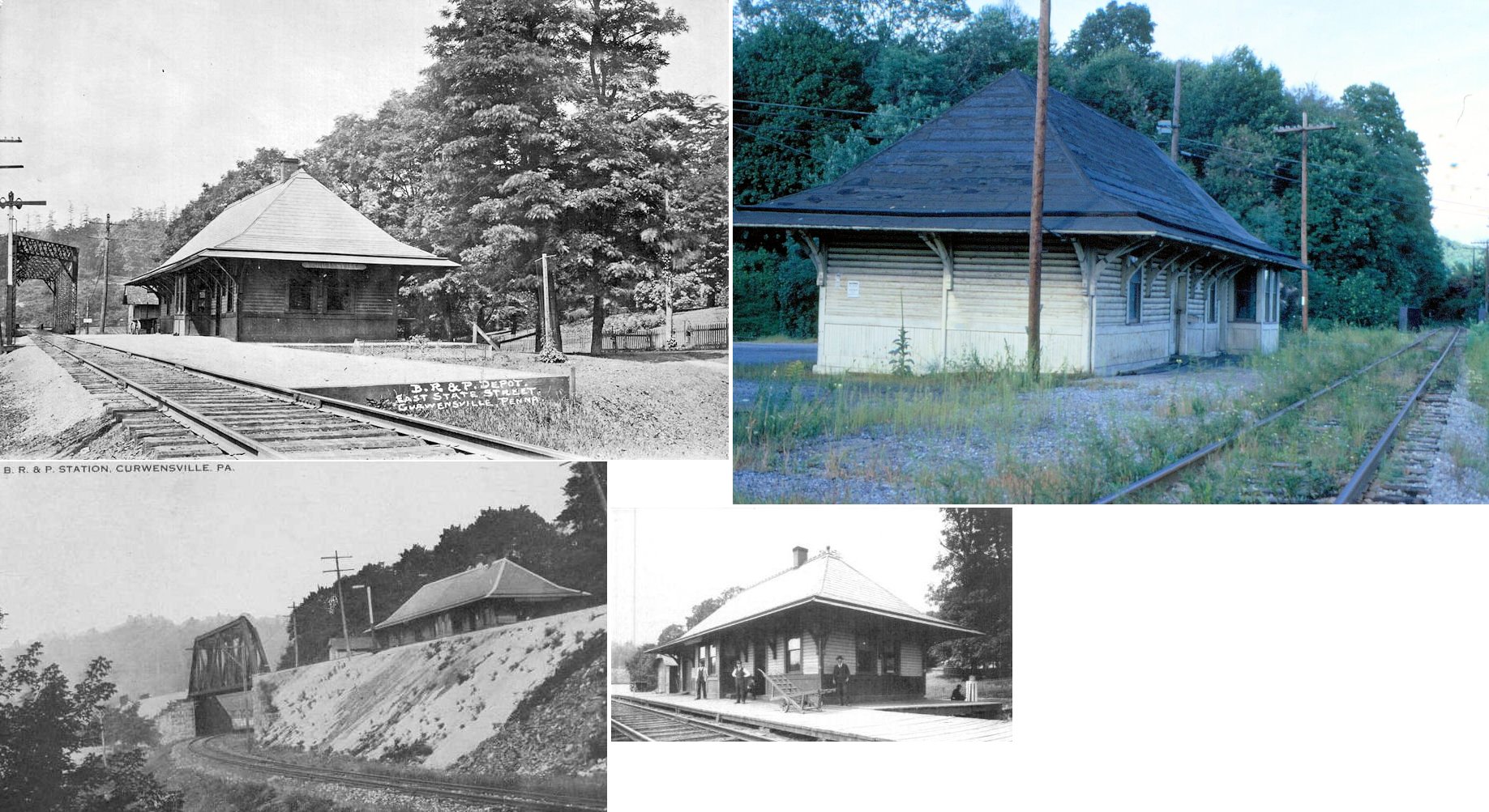
| Curwensville |
|
The original Tyrone & Clearfield RR station was a combination station at the same location as the existing passenger station at Meadow & Filbert Streets (GPS: 40.974058,-78.526478). This original station was replaced by the existing passenger station sometime between 1900-1905. At that time a separate freight station was built just to the west at GPS: 40.974159, -78.527230. | ||||||
| Curwensville |
|
When the new passenger station was built between 1900-1905 a separate freight station was built just to the west at GPS: 40.974159, -78.527230. There was also a baggage house between the passenger and freight stations that was connected to the passenger station. The freight station was bought in 1970 by Lezzer Lumber and torn down to make way for a warehouse (The Progress, 4-3-1972). | ||||||
| Curwensville |
|
This station was on the south side of East State Street on the NW side of the tracks at GPS: 40.974061, -78.522595. | ||||||
| Curwensville |
|
The NYC's Curwensville & Bower Branch ended here. It is unclear if there was a station here. | ||||||
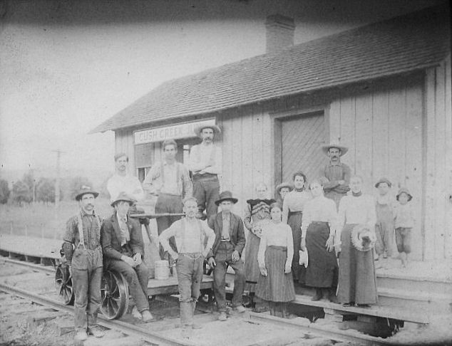
| Cush Creek Junction |
|
This station was between U.S. 219 and PA286 at approximately GPS: 40.834299, -78.791975. | ||||||
| Deer Station |
|
This was on the West Branch Valley Branch. The station was located in the vicinity of GPS: 41.064604, -78.206025. There are no roads to this location today. Even in 1942 when the station is shown on the map, there were no roads to the location. | ||||||
| Derby |
|
The Tyrone and Clearfield RRR reached the mine around 1864, and the depot was located opposite the tipple on the Derby Branch. | ||||||
| Dimeling |
|
|||||||
| Dowler Junction |
|
This station was on the west side of U.S. 219 at approximately GPS: 40.829541, -78.790321. | ||||||
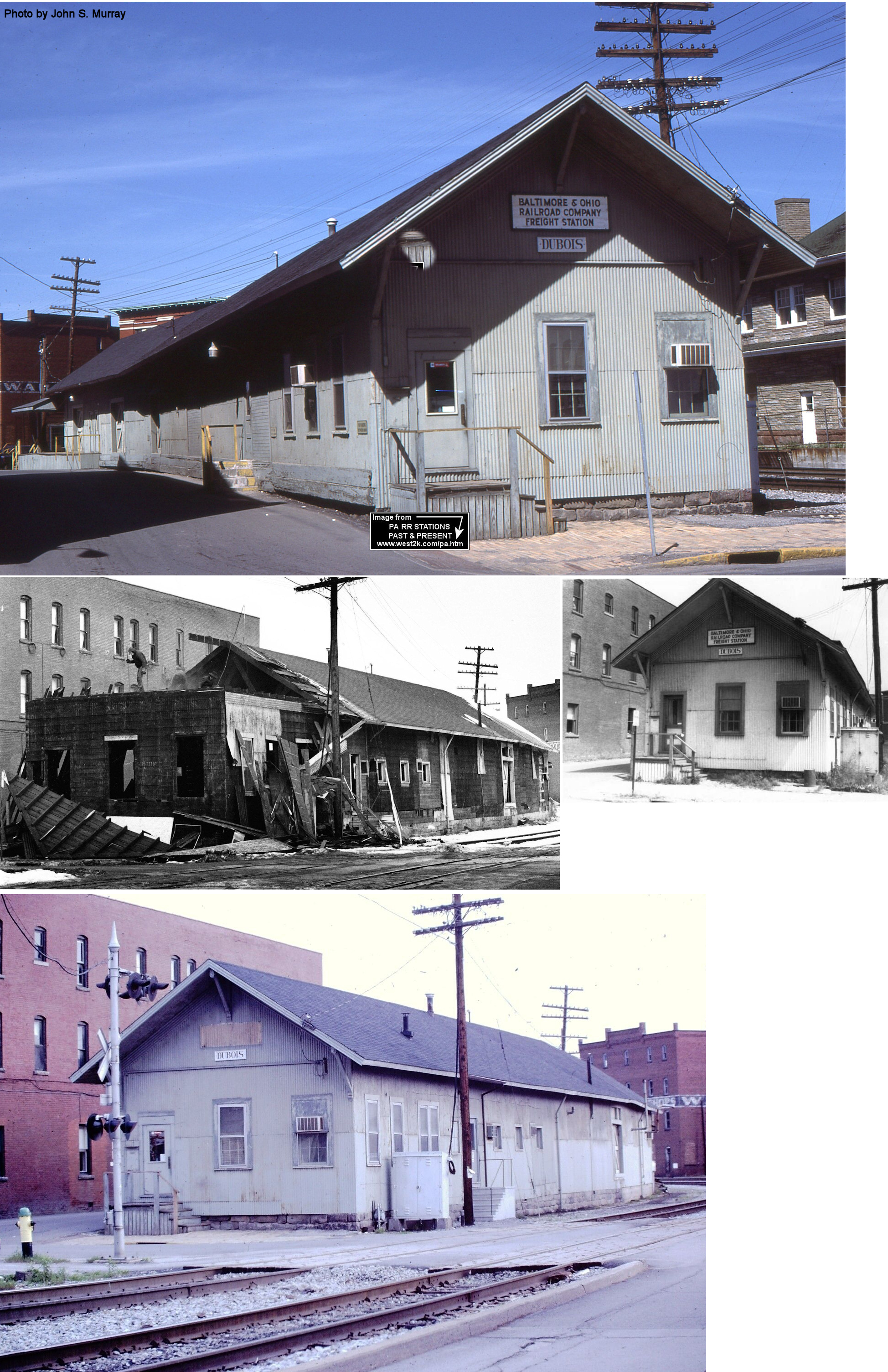
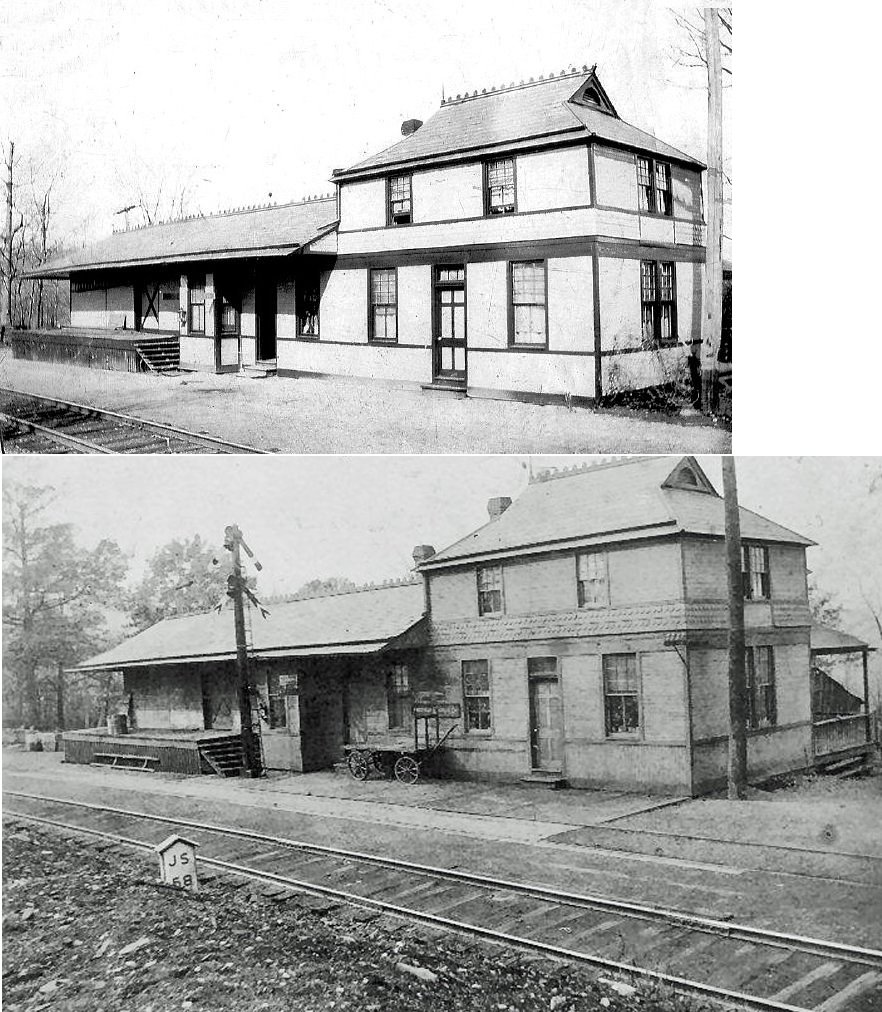
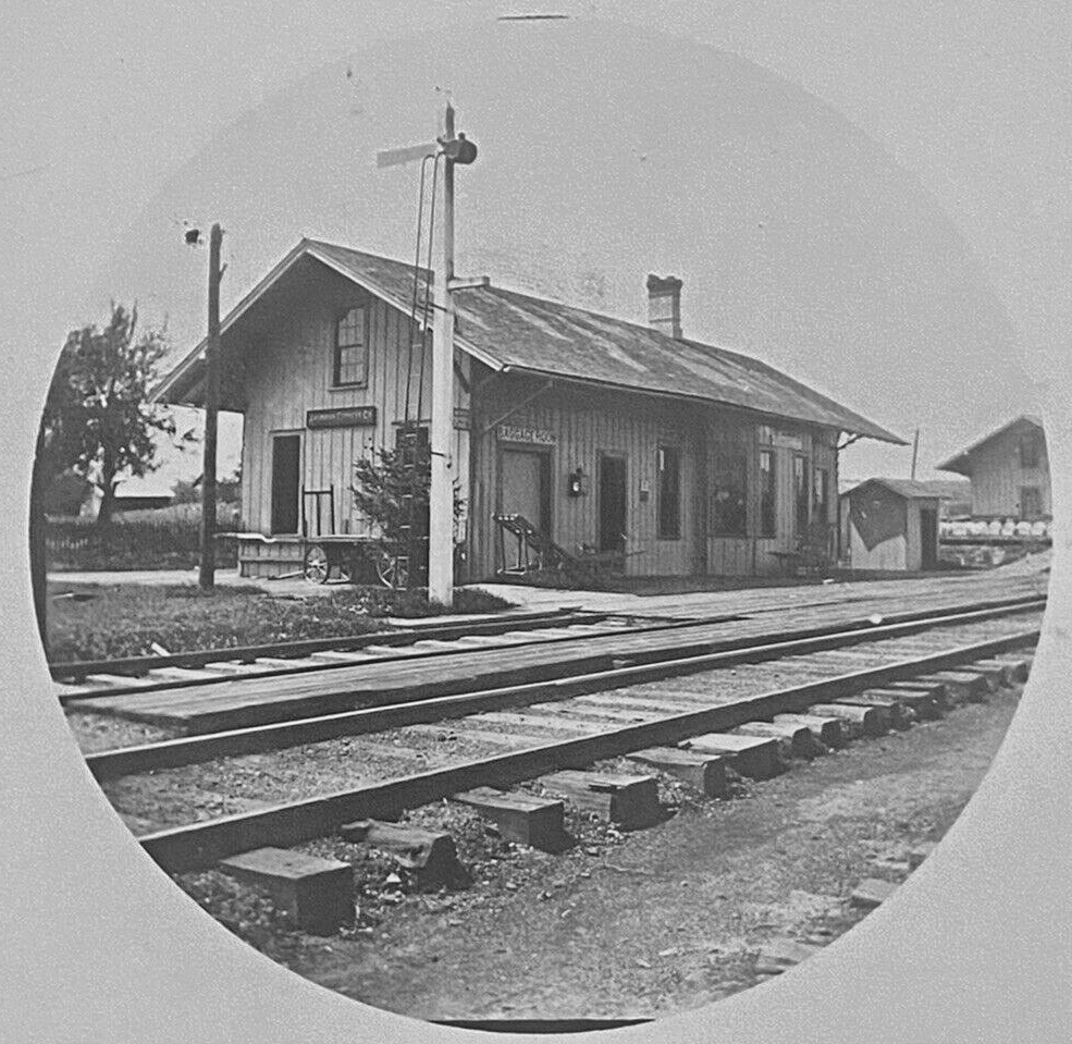
| Dubois |
|
The original wood frame BR&P station here was on the north side of Long Avenue on the west side of the tracks at GPS: 41.121924, -78.765700. Although the new brick station was built in 1894, the original station survived and stood vacant for a few years after as it is still shown on the 1896 map as being vacant. Is is not shown on the 1901 map. | ||||||
| Dubois |
|
A freight station was built on the north side of Long Avenue on the west side of the tracks in 1896 at GPS: 41.121422, -78.765895. This freight station was enlarged sometime between 1906-1913. It was torn down in the mid/late 1970s. | ||||||
| DuBois |
 |
This station was on the east side of US-219 along what is now the Beaver Meadow Trail at GPS: 41.120096, -78.758675 on North Brady Street. This was a terminal-type station as the tracks from the station spur ended here. After the station went out of service, it was used as a grain and feed storage warehouse. The building burned down on January 1, 1952 according to the The Progress newspaper of 1/2/52. | ||||||
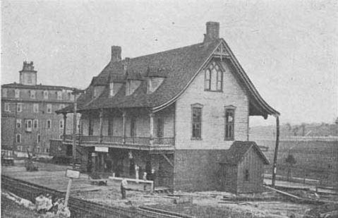
| Dubois |
|
The original passenger station was on what is now Park Place at GPS: 41.126784, -78.754261. The first station was a two-story (although in the photo, it appears to be three stories) wood frame station which was replaced by the brick PRR station. This building was a store owned by John Dubois which later came to house the PRR station. It remained in service until sometime between 1906-1913. | ||||||
| Dubois |
|
This frieght station was next to the passenger station near the corner of Depot Avenue and North Brady Street (now US-219 and North Park Place) (GPS: 41.126948, -78.754884). | ||||||
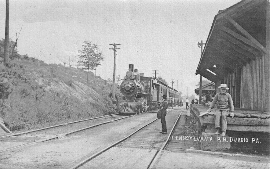
| Dubois |
|
This passenger station was on what is now Park Place at GPS: 41.126826, -78.754492. It was built sometime between 1906-1913 to replace the original wood frame AVRR station/Dubois Store Building. | ||||||
| Dubois |
|
The PRR built a new siding and freight house on the NW side of South Brady Street (US-219)sometime between 1906-1913. This brick freight house with wooden shipping shed was along what is now West Park Avenue at 41.120050, -78.760271. In 1962 the front of the building was removed to make way for the widening of Liberty Boulevard (DuBois Courier-Express, 4-16-1976). | ||||||
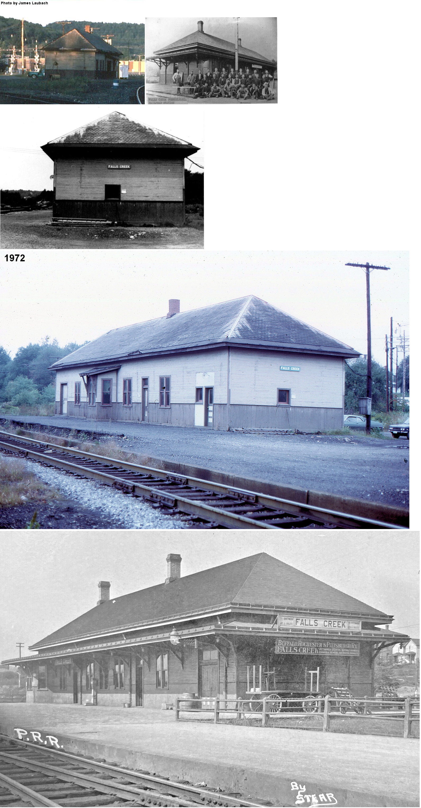
| Falls Creek |
AND  AND |
Shown on the 1878 map as the first station in Clearfield County on this line in Brady Township. This small 10x12 "coop" depot, called the "W Box," (Reynoldsville Star, 9-28-1892) was eventually used by all three railroads in Falls Creek. | ||||||
| Falls Creek |
AND |
The AVRR built a new 25'x100' station in 1893 that stood until the early 1980s. Before the BR&P built its own station it was a tenant at the AVRR station. This station was on Slab Run Road in the NW corner of the diamond at GPS: 41.142127, -78.794597. Although most of Falls Creek is in Jefferson County, the PRR and BR&P stations were just over the line in Clearfield County. | ||||||
| Falls Creek |
|
The BR&P station was in the SW corner of the diamond just south of where F.C. tower still stands today (as of 2021) off Slab Run Road. It was at GPS: 41.141886, -78.793969. | ||||||
| Faunce |
|
This was on the Clearfield Southern Branch. | ||||||
| Five Points Station |
|
This station was on the north side of Five Points Road at approximately GPS: 40.794139, -78.676174. | ||||||
| Frenchville Station (Coudley) |
|
This was on the West Branch Valley Branch. The depot was on Coudley Station Road at approximately GPS: 41.072417, -78.238255. On the 1942 map this location was known as Frenchville Station. | ||||||
| Gazzam |
|
|||||||
| Glendale |
|
|||||||
| Grampian |
|
A new station was built here in 1892. | ||||||
| Gray |
|
This was on the West Branch Valley Branch. Not to be confused with the Gray PRR station in Westmoreland County. | ||||||
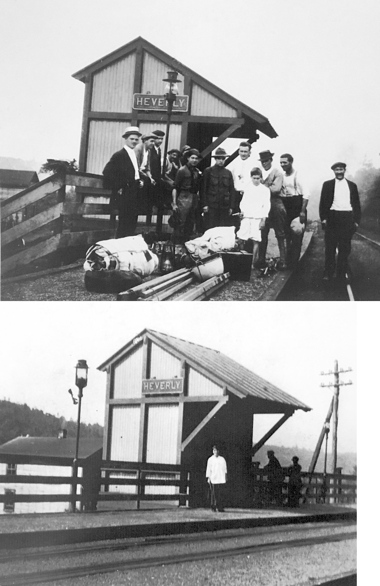
| Heverly |
|
This shelter-type station was between Utahville and Coalport at approximately GPS: 40.743160, -78.505661. It likely served the coal mine that was there which closed in 1933. | ||||||
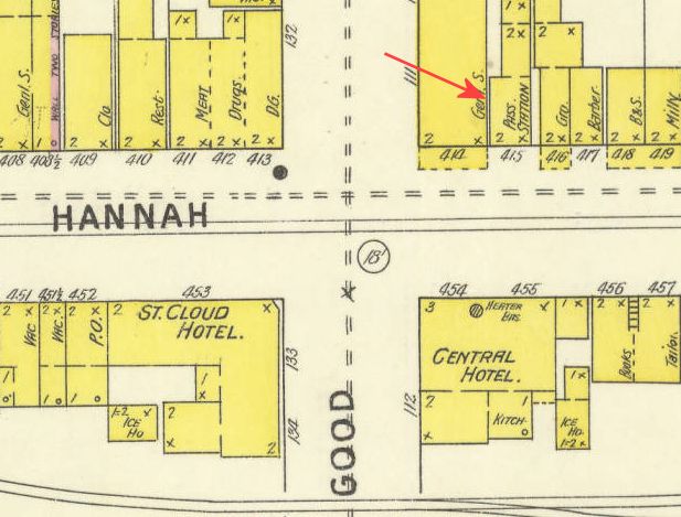
| Houtzdale |
|
On the 1894 map, the passenger station is shown at 726 Hannah Street (GPS: 40.825277, -78.352567) (now a deli?). A building still stands there with the same profile as that on the map. So, this building may have been the first A&P station, or this building may have been built there after the A&P station was torn down or moved. More research is needed on the date of the existing building. | ||||||
| Hoyt Station |
|
This station is showm in the vicinity of GPS: 40.915877, -78.619713 on the 1941 county map. | ||||||
| Ire |
|
|||||||
| Irvona |
|
|||||||
| Janesville (Smithmill) |
|
This station was on the north side of PA729 at approximately GPS: 40.760630, -78.423116. This was on the Janesville Branch. | ||||||
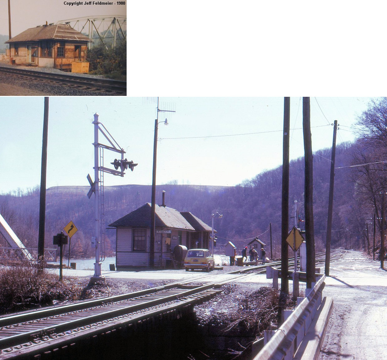
| Karthaus |
|
Torn down 1981. | ||||||
| Karthaus |
|
Perhaps this station predated the one listed above? The S&C was a predecessor of the NYC in that the S&C was a PRR-affiliate first and then the NYC bought the S&C from the PRR in 1901. | ||||||
| Kermoor |
|
|||||||
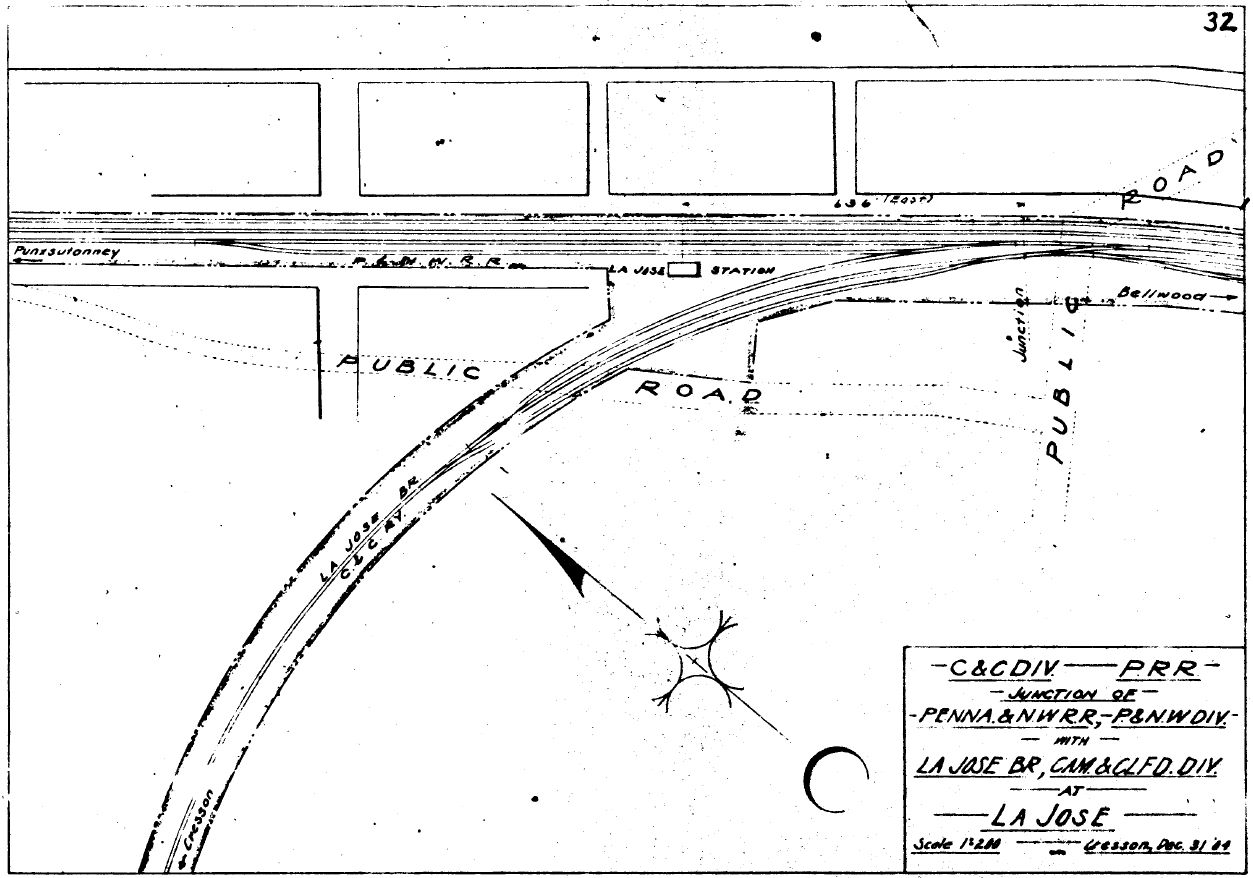
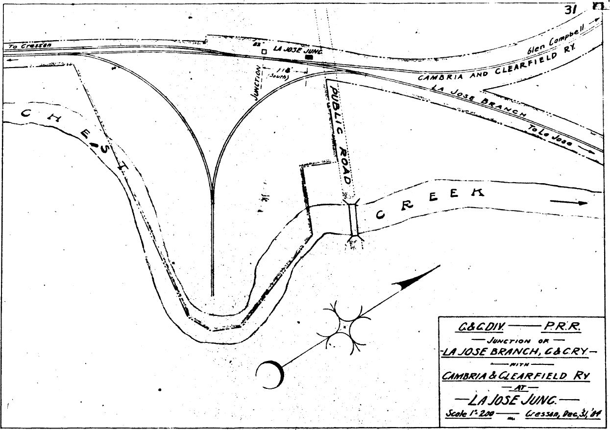
| La Jose (Newburg) |
|
This station was on the SW side of PA36 at approximately GPS: 40.836846, -78.679063. | ||||||
| La Jose Junction |
|
This station was on the north side of Town Road at approximately GPS: 40.834951, -78.684567. | ||||||
| Lambert |
|
This was on the Clearfield Southern Branch south of Dimeling. | ||||||
| Lawshe |
|
|||||||
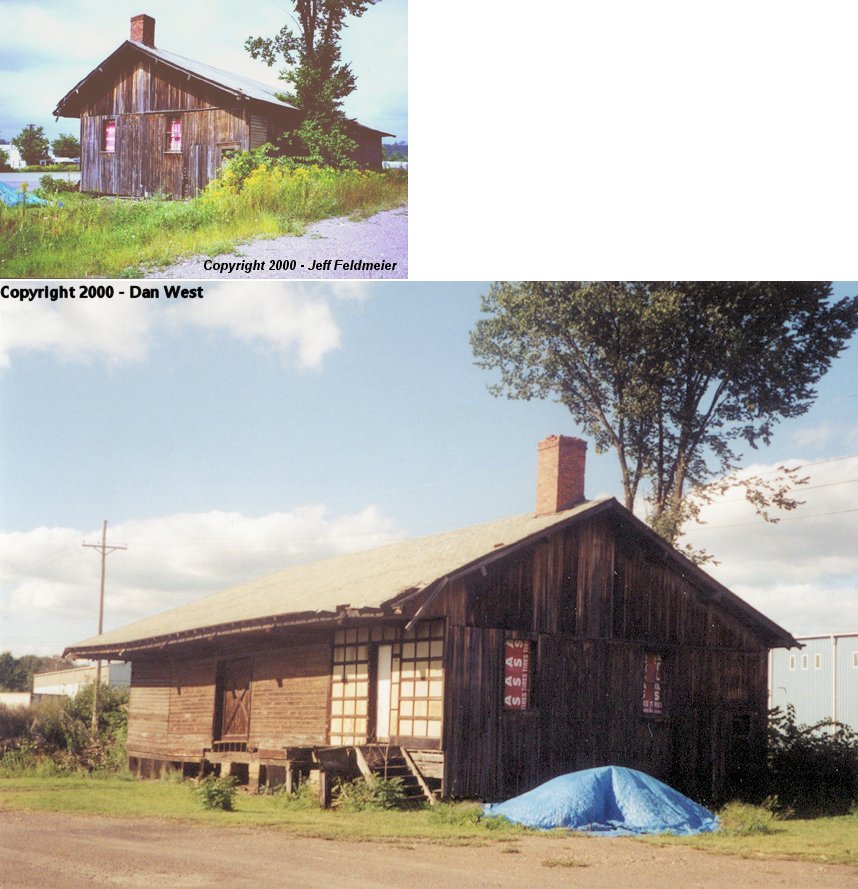
| Lumber City |
|
|||||||
| Luthersburg (Luthersburgh) |
|
This depot was on Station Road. | ||||||
| Madera |
|
This station was on the north side of Main Street just west of Clearfield Creek at approximately GPS: 40.827634, -78.437246. | ||||||
| Madera |
|
This station was at the corner of of the bend in Lynn Street at approximately GPS: 40.829871, -78.437263. A new station was built here in 1887. | ||||||
| Mahaffey |
|
|||||||
| Mahaffey |
|
|||||||
| Mayes |
|
|||||||
| Mc Cartney |
|
|||||||
| Mc Cauley |
|
|||||||
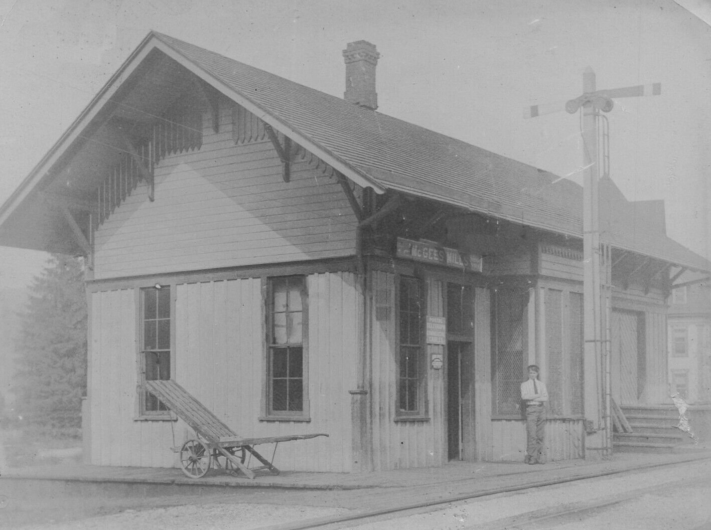
| McGees Mills |
|
This station was on on Covered Bridge Road at approximately GPS: 40.880649, -78.764879. | ||||||
| McGees Mills |
|
This station was on the north side of U.S. 219/PA 36 at approximately GPS: 40.881533, -78.760447. | ||||||
| McGees Mills |
|
This station was on the NW side of U.S. 219 at approximately GPS: 40.880390, -78.766208. | ||||||
| Millikins |
|
|||||||
| Millvale |
|
|||||||
|
Mitchell (O'Shanter) |
|
Mitchell was the railroad's name for O'Shanter. | ||||||
| Morrisdale |
|
This station was at the intersecton of at Morrisdale Allport Highway, Deer Creek Road and Pardee Road at GPS: 40.948642, -78.225758. | ||||||
| Moshannon |
|
|||||||
| Mowry |
|
This was on the West Branch Valley Branch. According to the 1942 map, the station was located in the vicinity of GPS: 41.060946, -78.137063. There are no roads to this location today. Even in 1942 when the station is shown on the map, there were no roads to the location. | ||||||
| Munson |
|
This station was on the north side of Cassanova Road just past the bridge over the Moshannon Creek at GPS: 40.955273, -78.170212 as shown on the 1917 Sanborn map. | ||||||
| Narrows Creek |
|
This station is listed on the 1923 PRR List of Stations & Sidings. It was in the general vicinity of GPS: 41.136634, -78.696263. | ||||||
| Newburg |
|
See listing above for La Jose. | ||||||
| New Millport |
|
|||||||
| New Washington |
|
The freight station here was destroyed due to a derailment in August, 1951. | ||||||
| Olanta |
|
|||||||
| Osceola Mills |
|
This station was on Phoenix Road just east of PA970 at GPS: 40.849354, -78.262201. A station is shown here on the 1878 map. In 1904 the stations called "Osceola" and "Osceola Town" were merged into "Osceola Mills." At some point one of these stations was known as "Mill Street" as well. The stations were originally 1.2 miles from each other. | ||||||
| Osceola Mills |
|
There was a freight station just south of the intersection of Railroad Street and Lingle Street at GPS: 40.849055, -78.270455. | ||||||
| Osceola Mills |
|
The 1931 Moshannon Branch timetable lists Mill Street in Osceola Mills as a stop. Was there a station there as well? | ||||||
| Osceola Mills |
|
There was a freight station on the NW side of Logan Street north of Curtain Street at GPS: 40.851121, -78.266033. There is a building on this site now, but it appears to be a newer building at a slightly different angle than the freight station was. This station is shown on the 1910 Sanborn map when the RR was called the Phillipsburg & Susquehanna Valley RR (previously the Altoona & Philipsburg RR). | ||||||
| Ostend |
|
|||||||
|
Patchinville (Patchen) |
|
|||||||
| Payne |
|
|||||||
| Peale |
|
This station was on the north side of the tracks on the east side of Peale Road. It also served as a residence for the station agent. | ||||||
| Peale |
|
Perhaps this was a later station? | ||||||
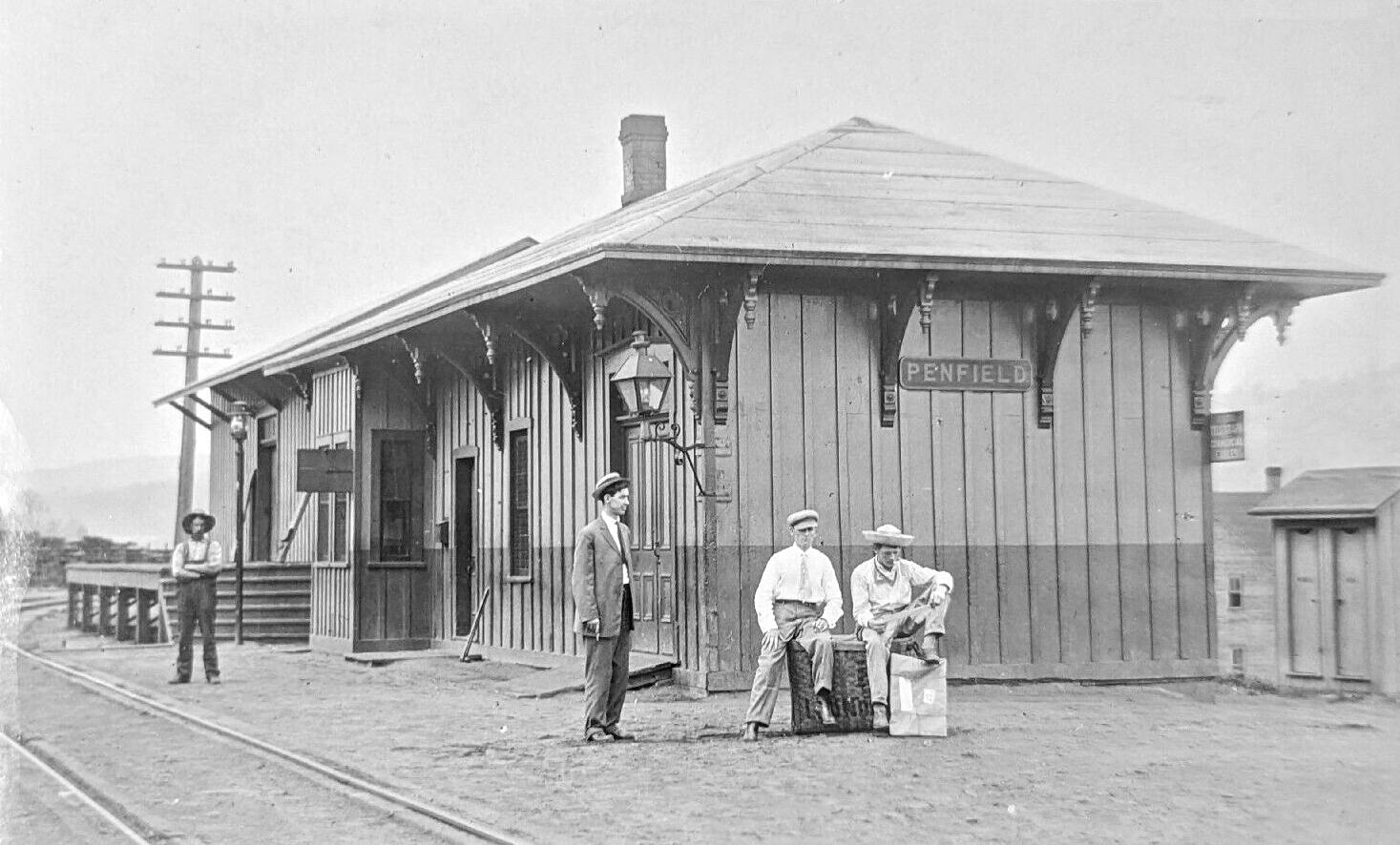
| Penfield |
|
This station was on Tannery Drive at approximately GPS: 41.204170, -78.573083. | ||||||
| Penfield |
|
This station was on the NE side of PA153 at approximately GPS: 41.207947, -78.573939. | ||||||
| Ramey |
|
|||||||
| Rosebud |
|
This station was on the north side of Mill Street at approximately GPS: 40.749641, -78.538565. | ||||||
| Rush |
|
This was on the West Branch Valley Branch. | ||||||
| Sabula |
|
This station was downgraded to a flag stop by the PRR in 1915. It previously handled both passengers and freight. | ||||||
| Sabula |
|
This station was located southwest of the former bridge carrying the B&S main line over Hubler Road at the west end of the Sabula Tunnel, near GPS 41.152567, -78.665645. | ||||||
| Salem |
|
|||||||
| Shaffer |
|
The 1923 PRR List of Stations & Sidings list a passenger station here. This station was in the vicinity of Shaffer Road and PA255 east of Dubois. | ||||||
| Shawsville Station |
|
This was on the West Branch Valley Branch. The station was off old Kyler Road not far from the east portal of the tunnel at approximately GPS: 41.069705, -78.349850. | ||||||
| St. Lu |
|
|||||||
| Stanley |
|
A station was built here in 1912. | ||||||
| Steiner's Station |
|
A small Tyrone & Clearfield station is shown here on the 1878 map and also on the 1910 Sanborn map. It was located on the NW side of the tracks at the Phillipsburg Fire Brick Company. There are no streets in this area now, but the station was at approximately GPS: 40.888172, -78.226112. This is past the SE end of Laura Street in Chester Hill. | ||||||
| Sterling |
|
|||||||
| Stoneville |
|
A new combination station opened here in 1881. | ||||||
| Surveyor |
|
This station was west of the intersection of PA879 and Surveyor Run Road at approximately GPS: 41.073178, -78.326892. There was a mine spur near the station that followed Surveyor Run to the NE. | ||||||
| Tyler |
|
Shown on the 1878 map as "Tyler's Station." The station was on the south side of Nitrate Street NE of Tyler Road at approximately GPS: 41.238811, -78.527465. | ||||||
| Tyler |
|
This station was on the NE side of Tyler Road at approximately GPS: 41.239385, -78.528988. | ||||||
| Tyler |
 |
The 1941 county map indicates that there may have been a station in the vicinity of GPS: 41.239644, -78.538249. that map shows the line ending at a mine near that location. | ||||||
| Utahville |
|
|||||||
| Viaduct |
|
|||||||
| Wallaceton |
|
This station was at the intersection of Baughman Street and Clearfield Street on the NE side of the tracks at GPS: 40.958840, -78.288549. It was about 100 feet NE of the PRR station listed below. | ||||||
| Wallaceton |
|
The original Tyrone & Clearfield station was on the NW side of Baughman Street on the NE side of the tracks as shown on the 1878 map (GPS: 40.958607,-78.288901). A station is shown at this same location on the 1917 map. | ||||||
| Walton |
|
This was on the West Branch Valley Branch between Shawsville and Frenchville. | ||||||
| Westover |
|
This station was at the corner of McEwen Street and Railroad Street at GPS: 40.751656, -78.668635. A new station was built here in 1889. | ||||||
| Whiteside |
|
|||||||
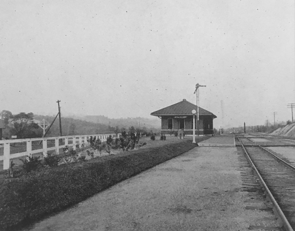
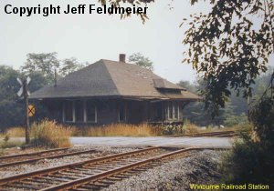
| Winburne |
|
|||||||
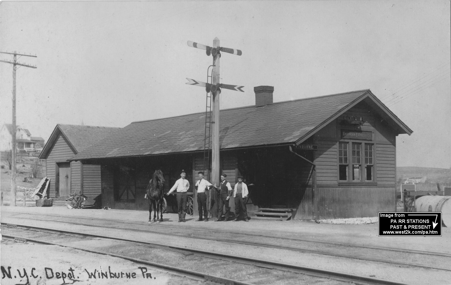
| Winburne |
|
Burned down by Conrail in mid 1983 or 1984. Sat beside Avondale hotel. | ||||||
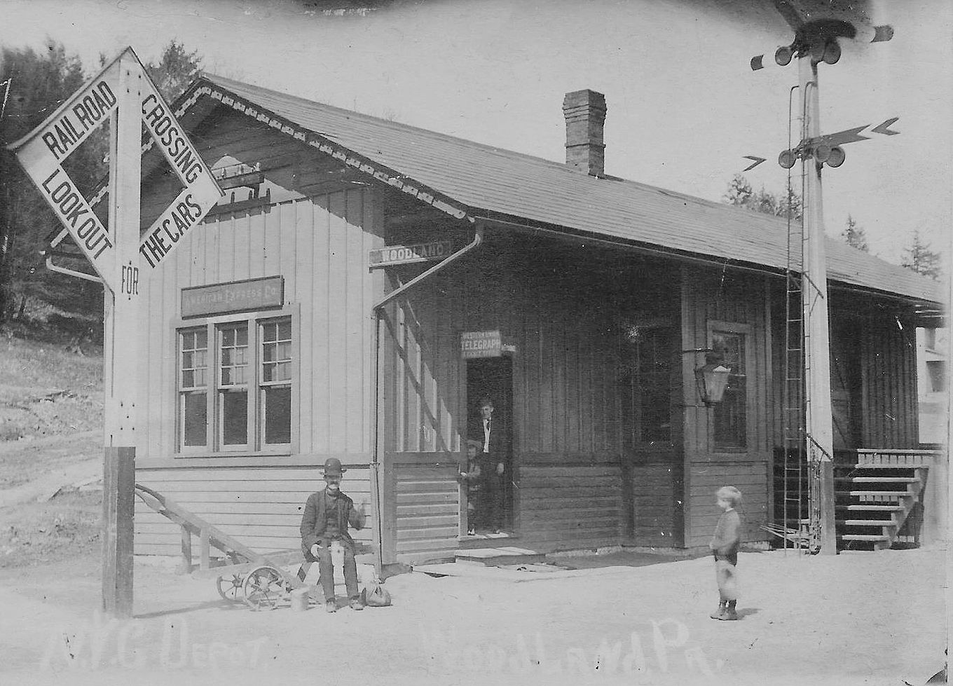
| Woodland |
|
According to the 1942 map, this station was on the west side of Spruce Street at approximately GPS: 40.994609, -78.348166. | ||||||
| Woodland |
|
This station was at the intersection of Main Street and Pinetop Road at approximately GPS: 40.995664, -78.347217. | ||||||
| Wrights |
|
|||||||
| 1895 CLEARFIELD COUNTY RAILROAD MAP | ||||||||
|
|
||||||||
| Notes About Existing
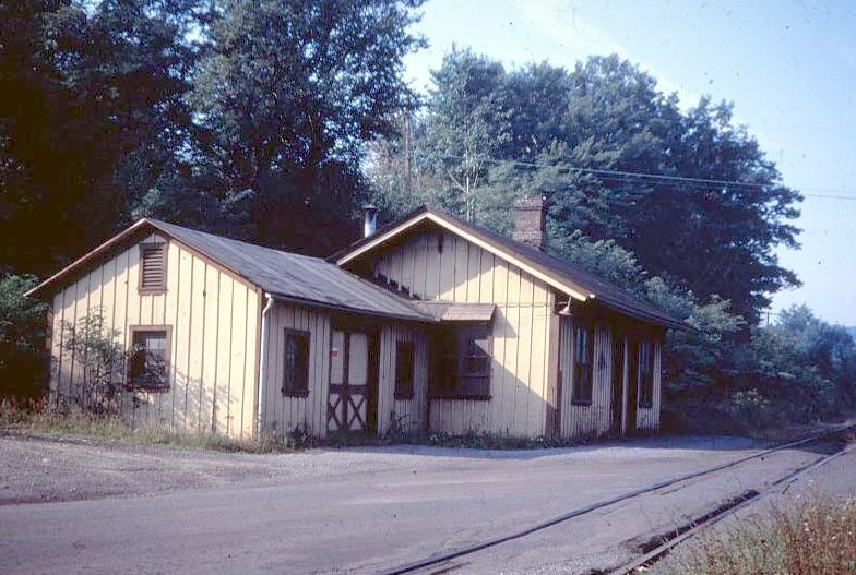
Stations... Brisbin (PRR) - Brisbin was on the Moshannon Branch of the PRR. Station is in its original location here. May be an original Phillipsburg & Moshannon station as it is shown as such on the 1894 map. Burnside (Beech Creek Extension) - Owned by the Borough of Burnside. Attempts underway to get it added to National Register of Historic Places and obtain funding for restoration. The BCE RR included the Canoe Creek Railroad and Clearfield Southern Railroad and was a separate company from the Beech Creek Railroad although both were later part of the NYC. Clearfield (PRR) - Tracks were in the street on Third Street. This has been a laundromat since the 1960s. Houtzdale (Alley Popper) - This station was not shown on the 1894 map (but the RR is), so was likely built after that and was likely the second passenger station or moved there. The "Alley Popper" RR was built as a competitor to the PRR in the Moshannon Valley. It was in financial distress for its entire life and ceased operations in 1931 and was abandoned in 1936. The "Alley Popper" was its more popular name and is more recognized than its barrage of formal names over its troubled life. The railroad was known by various names over its lifetime or owned in full or part by: Altoona & Philipsburg Connecting RR, New York & Pittsburgh Airline RR, Philipsburg RR, Philipsburg & Susquehanna Valley RR, and Pittsburgh & Susquehanna RR. Leasing Railroads: Pittsburgh, Johnstown, Ebensburg & Eastern RR, New York & Pittsburgh Central RR and Philipsburg & Johnstown RR. Irvona (NYC) - The station was originally located at the east end of Julia Street at GPS: 40.773837, -78.549069. It was torn down in the 1960s and rebuilt for another use in Blain City on private property. The station now only vaguely resembles its original shape so it is a stretch to say this station still exists outside some of the materials. Rockton (BR&P) - Station was originally built in 1898 for Buffalo, Rochester & Pittsburgh Railroad at Rockton PA on the Clearfield Branch. The depot was dismantled and first moved to Sloan Cornell's Penn View Mountain Railroad near Blairsville PA in the 1970's. The depot was dismantled and moved a second time to Gettysburg PA on Sloan Cornell's Gettysburg Railroad in the late 70's. An expansion of the nearby Gettysburg College later necessitated the station to be dismantled and placed in storage. The station was moved a third time and recently reassembled in Kane PA on Cornell's Knox and Kane Railroad. The reassembly was in progress when the tornado destroyed several piers of the Kinzua Bridge. The station has been finished, but regular passenger and freight service has ceased on the K&K, and the railroad is for sale. - Kevin Moore, 2007. Smoke Run (PRR) - Moved to present location late 1960's. The original location was on the north side of Crossroads Boulevard at approximately GPS: 40.795484, -78.430049. Lumber City? (Beech Creek/NYC) - According to the current owner, this station was moved from Lumber City in two pieces and is now being used as a cabin. When it was moved there, the propert was a chruch camp. Aerial photos of its current location show that the station was not there in 1958, but was there by the October 1968 photo. So, it was likely moved there sometime in the very late 50s or 1960s. Here is an old photo of the Lumber City depot. It certainly does resemble it, however, aerial photos show the Lumber City depot in its original location in 1939, but gone by 1958. So if this is the Lumber City station, it would have had an intermediate location before being moved to its current location. More research/photos are needed to confirm this. Winterburn (Allegheny Valley RR) - Used as a hunting cabin, a two-story addition was put on it in the 1930's. Original station was about 11' X 22' inside plus porches. The original cement steps are still out front. A station is shown at Winterburn on the 1878 atlas and is listed on the 1923 PRR List of Stations & Sidings. |
||||||||