|
|
||||||||
| EXISTING STATIONS | ||||||||
|---|---|---|---|---|---|---|---|---|
| Station Name |
Original Railroad |
Current Location |
Type | Current Use |
Date Built |
Track Status |
Building Material |
More Info |
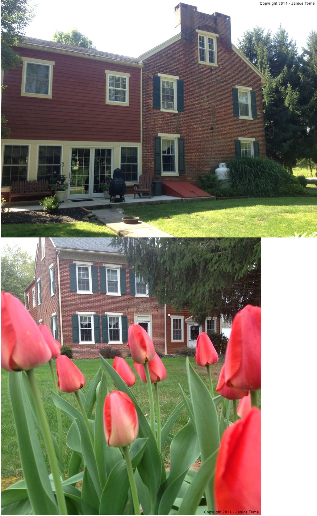
| Brillhart Station |
 |
2420 Brillhart Station Road (GPS: 39.909179, -76.754536) |
C | Business | ???? | In Use | Brick |
|
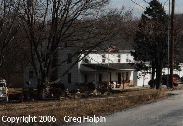
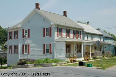
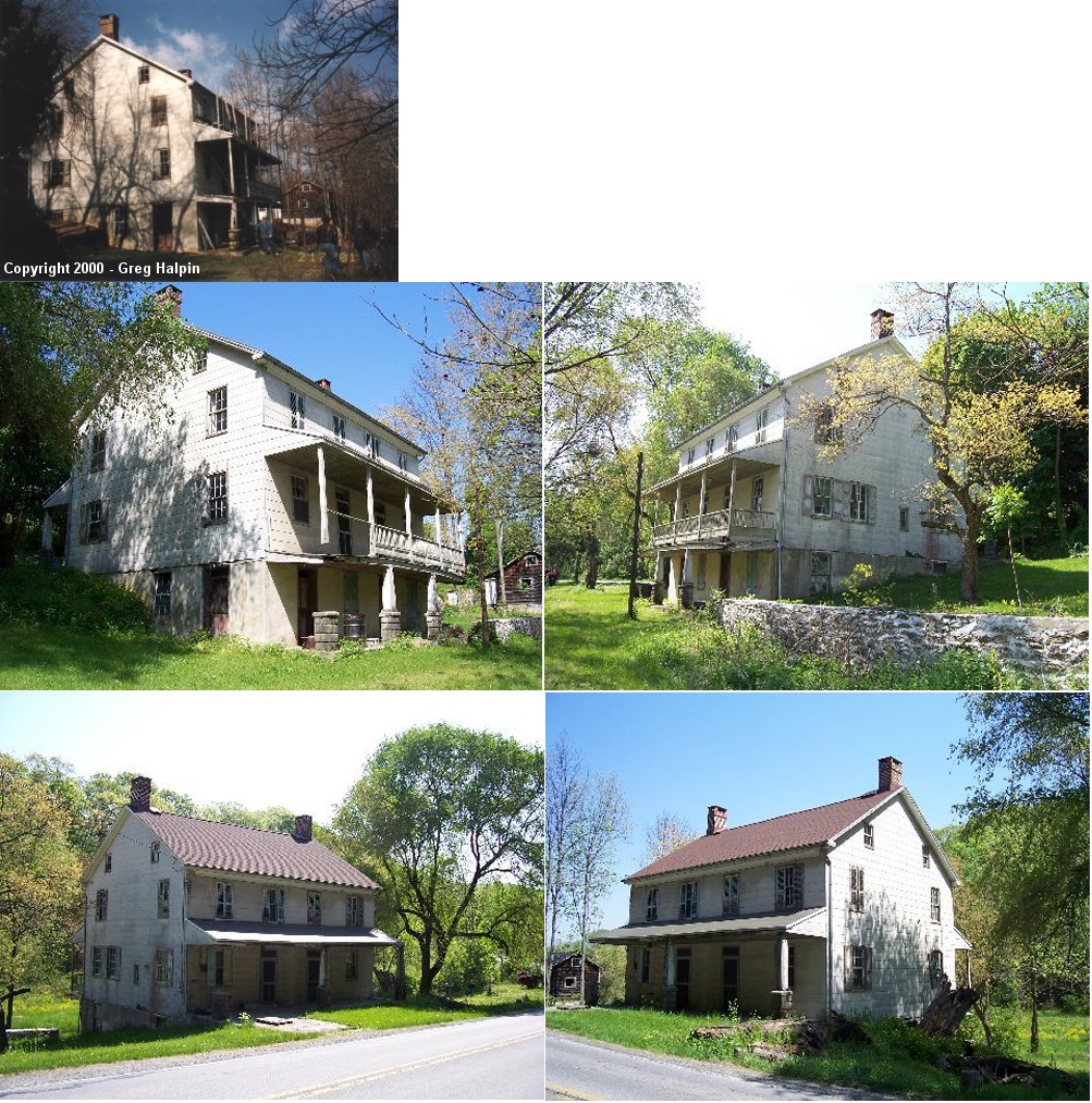
| Brogueville |  |
2632 Trinity Road (GPS: 39.842162, -76.531974) |
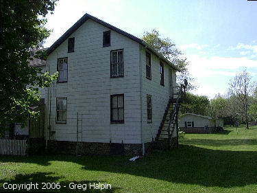
C | Residence | ???? | Gone | Wood |
|
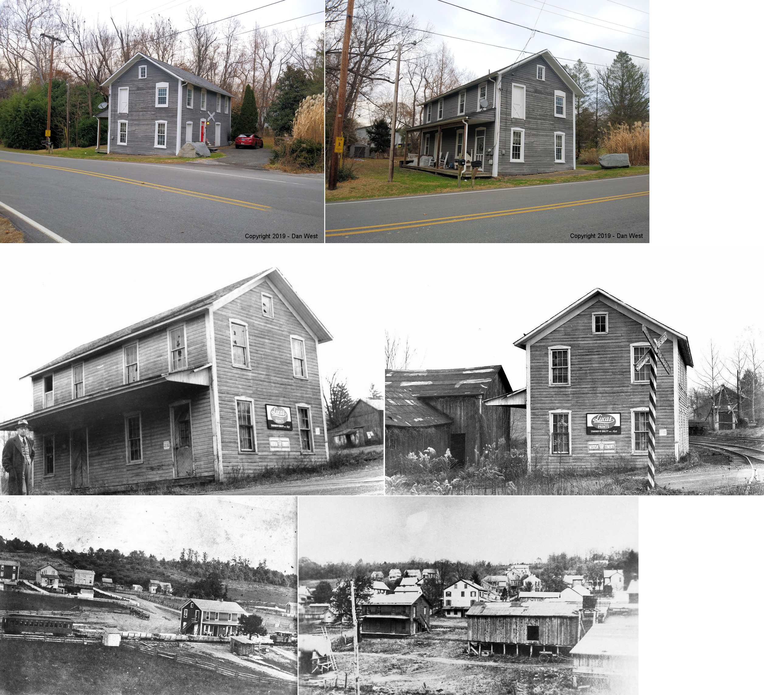
| Delta |  |
301 Broad Street at Front Street (39.730146, -76.321937) |
P | Residence | 1868 | Gone | Wood |
|
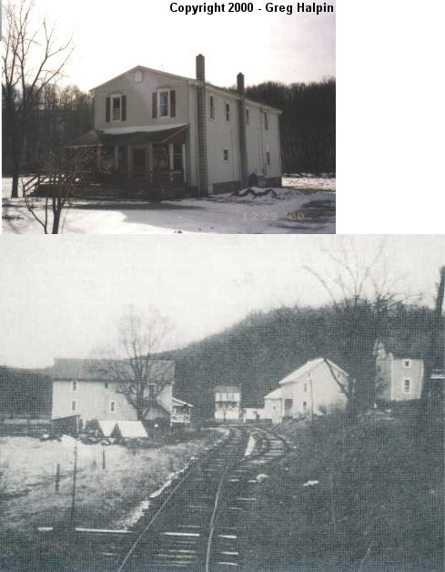
| Fawn Grove |
 |
West side of Market Street at Mill Street (GPS: 39.730193, -76.451936) |
C | Residence | ???? | Gone | Wood | |
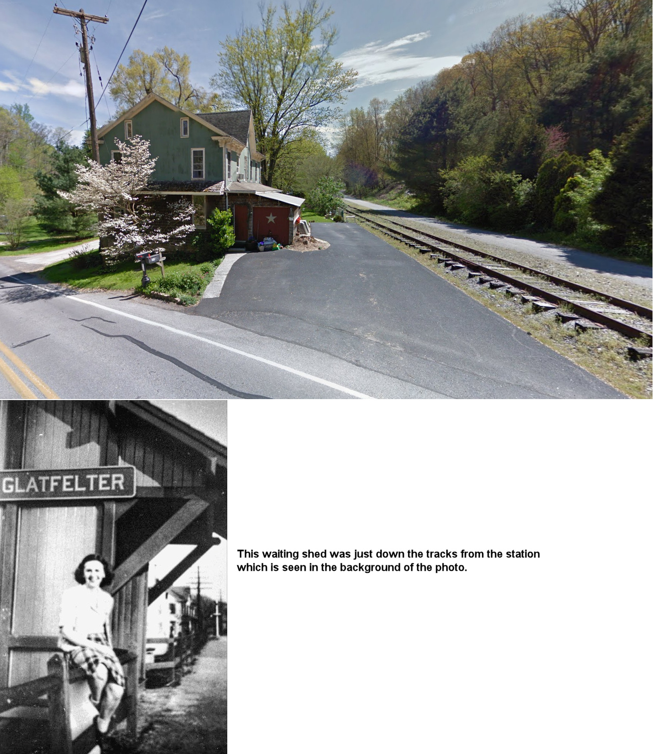
| Glatfelters |  |
South side of Glatfelters Station Road on the east side of the trail (GPS: 39.874376, -76.750014) |
P | Residence | ???? | Abandoned | Brick |
|
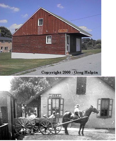
| Hallam (Hellam) |
 |
East Cherry Avenue (GPS: 40.006288,-76.602792) |
F | Storage | ???? | Gone | Wood |
|
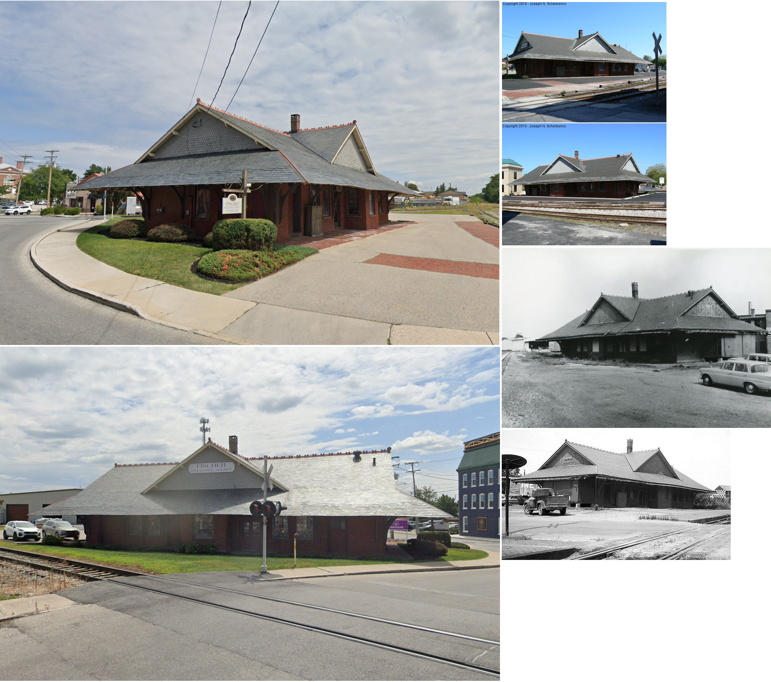
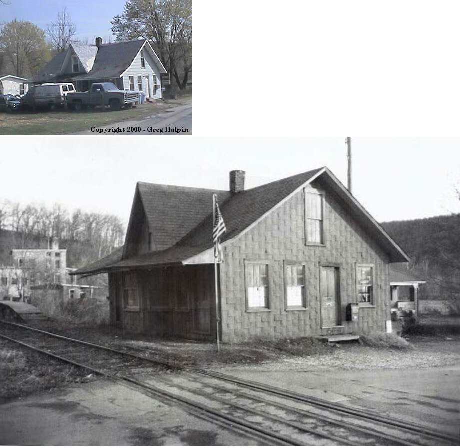
| Hanover |  AND |
Railroad Street & Library Place (GPS: 39.804312,-76.985697) |
P | Business | 1889 | In Use | Brick | |
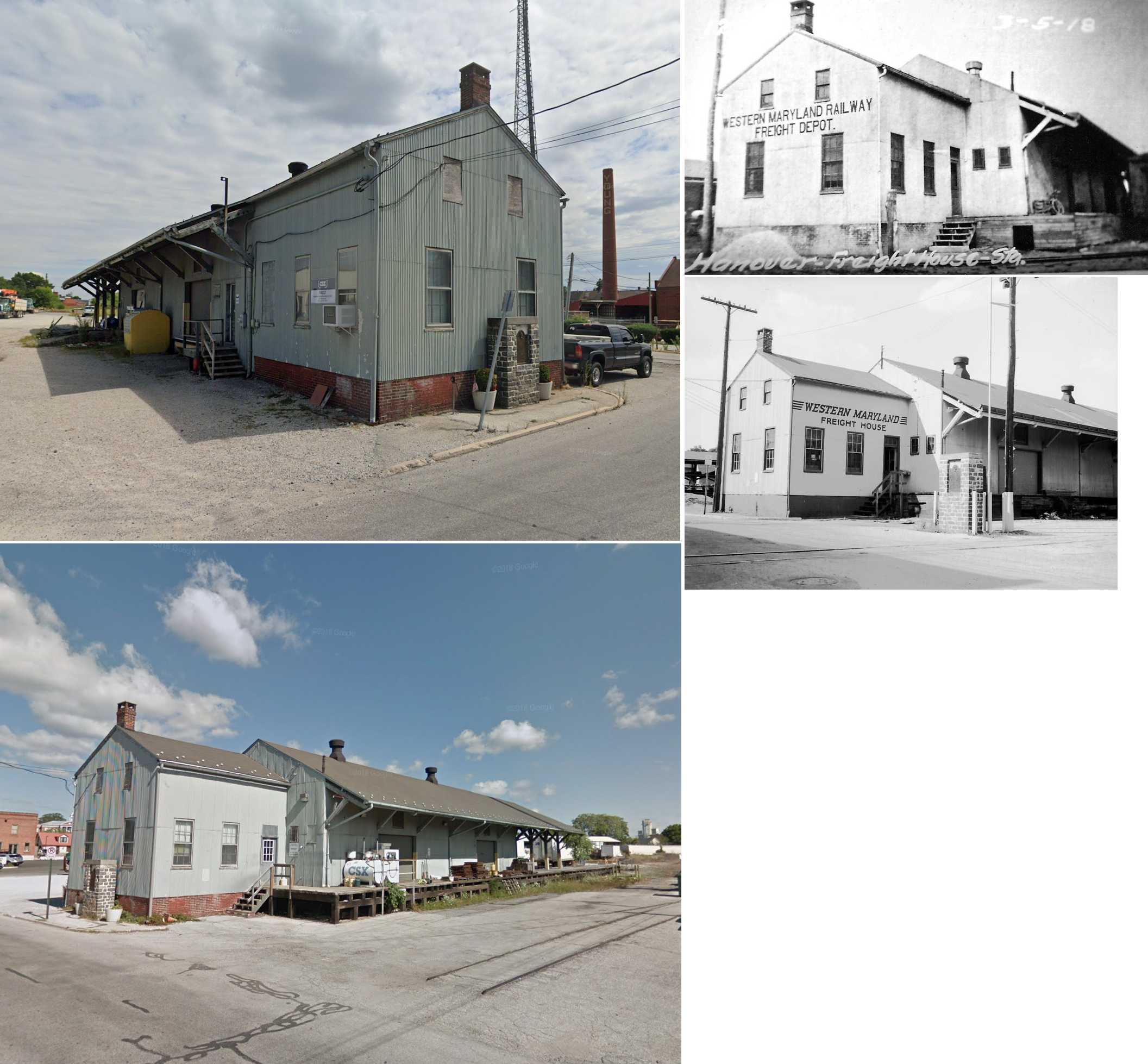
| Hanover | |
Railroad Street at Park Avenue (GPS: 39.803477,-76.984814) |
F | Railroad | ???? | In Use | Wood/Metal |
|
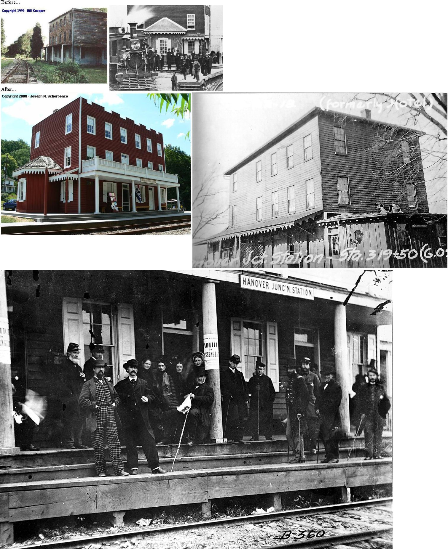
| Hanover Junction |
AND |
PA616 near Shaffers Church Road (GPS: 39.843942, -76.777084) |
C | Civic | 1860s | In Use | Wood |
|
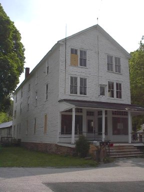
| Laurel | |
14600 Laurel Road (GPS: 39.825963, -76.510418) |
P | Business | ???? | In Use | Wood |
|
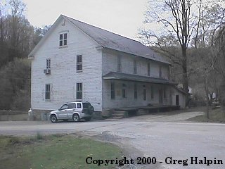
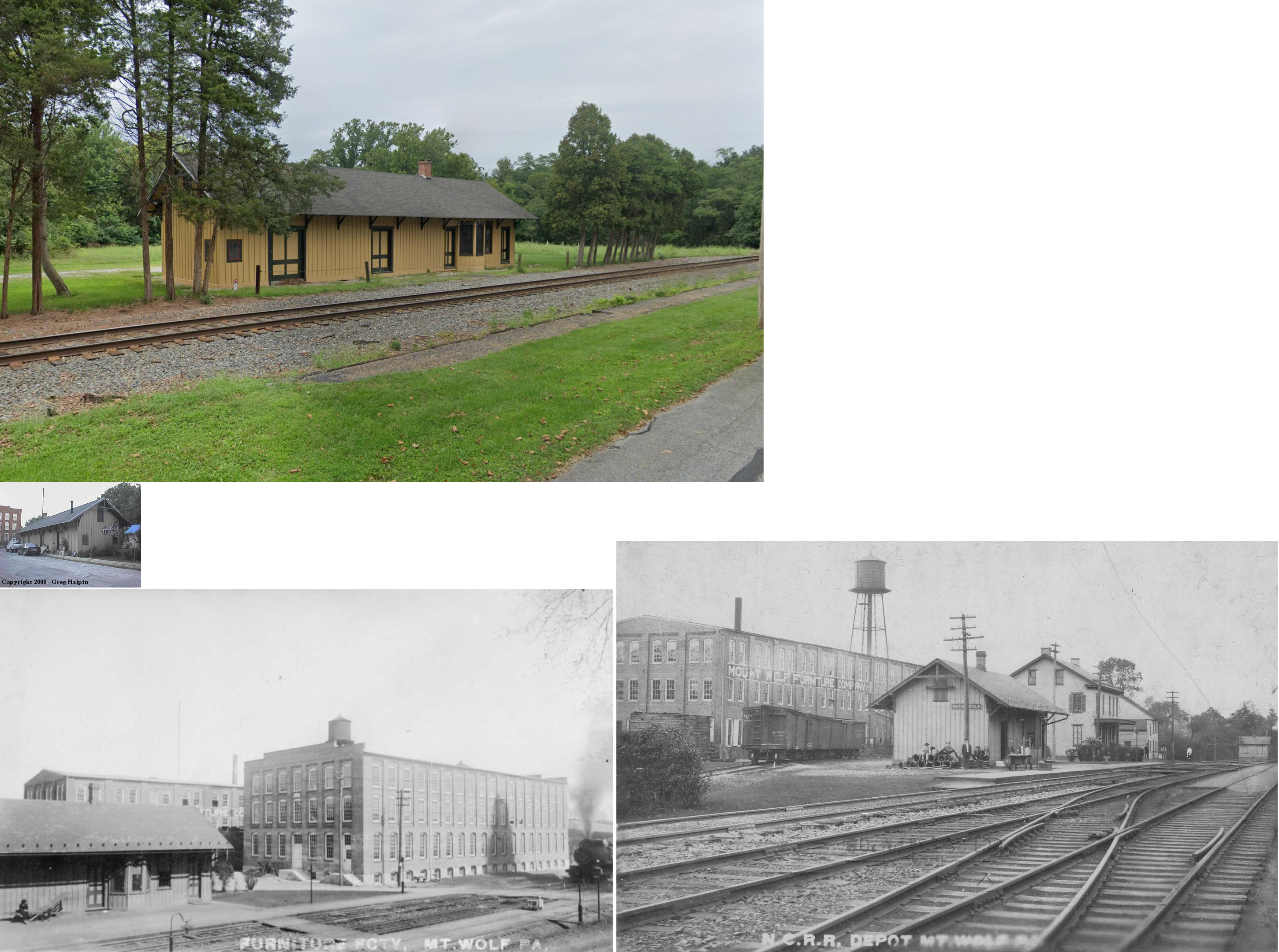
| Mt. Wolf |
|
Front Street near Centre Street (GPS: 40.065058, -76.709051) |
C | Private | ???? | In Use | Wood | |
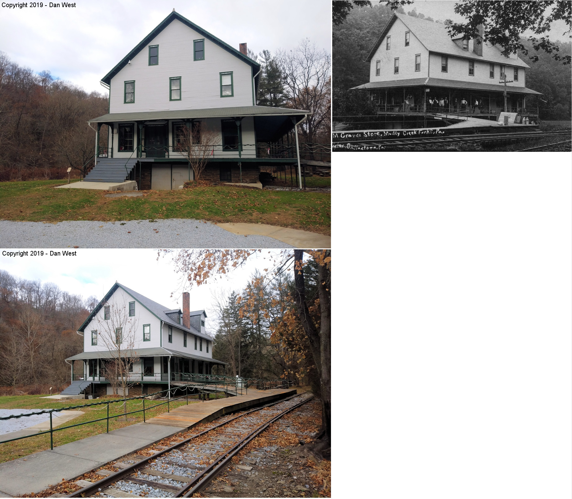
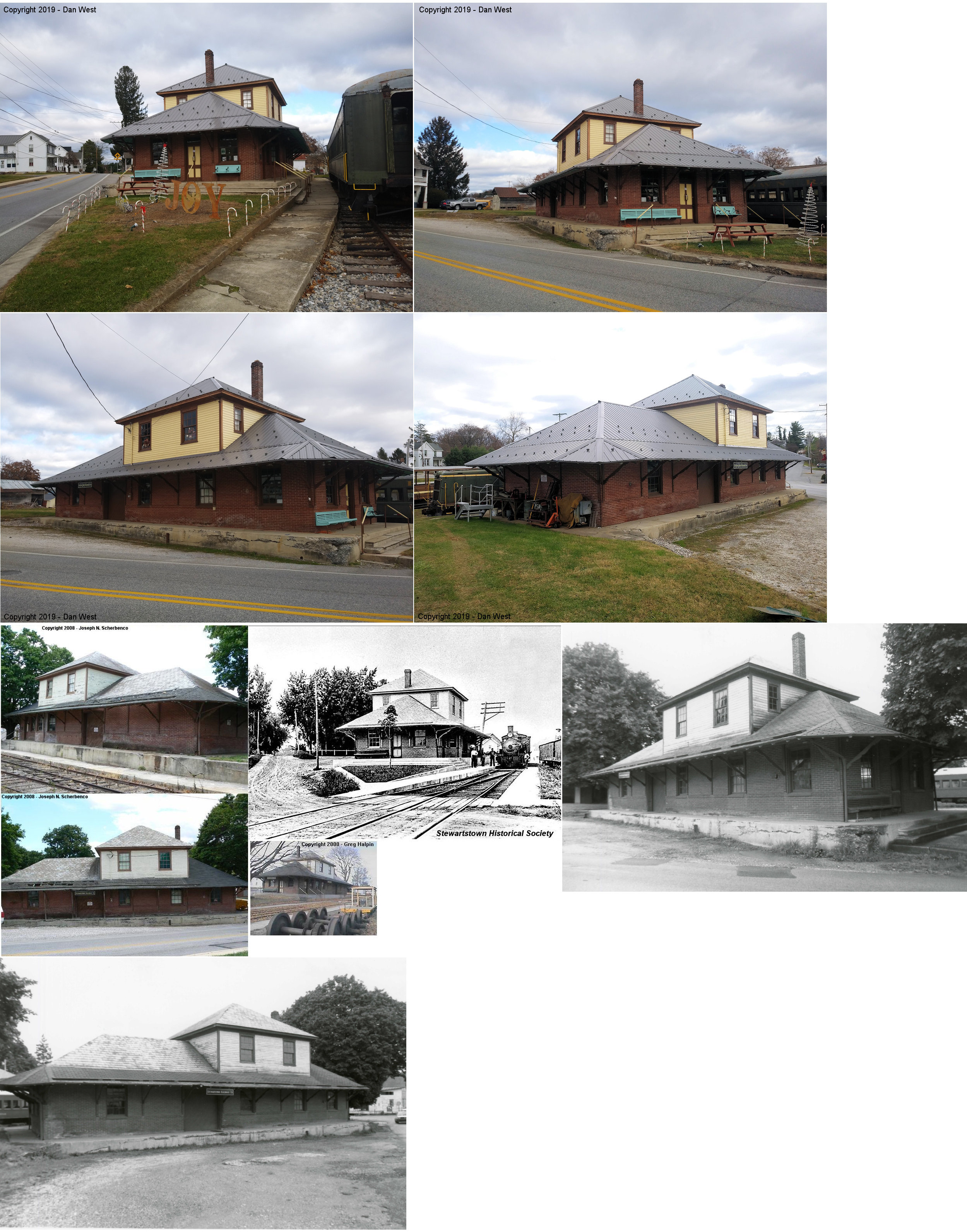
| Muddy Creek Forks | |
1268 Muddy Creek Forks Road (GPS: 39.808531, -76.475628) |
C | Museum | 1900 | In Use | Wood |
|
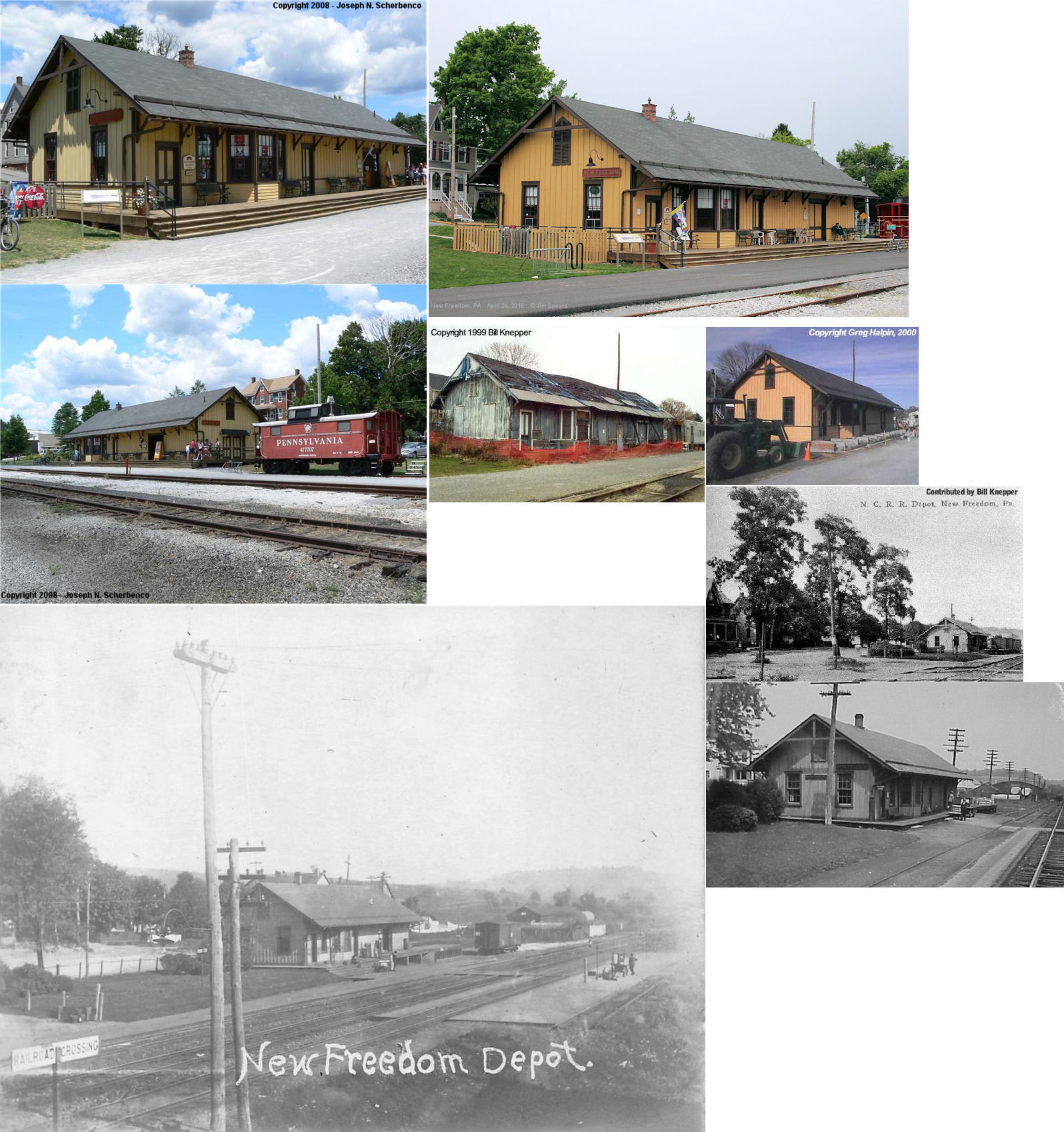
| New Freedom |
|
117 North Front Street at Franklin Street (GPS: 39.740085, -76.700643) |
C | Business | 1885 | In Use | Wood |
|
| Orwig |
 |
3030 Bridgeview Road (PA851) (GPS: 39.760613, -76.628286) |
P | Residence | ???? | In Use | Wood | |
| Red Lion | |
73 North Main Street (GPS: 39.902182, -76.607869) |
C | Civic | 1925 | Gone | Brick |
|
| Relay | |
380 Fruitlyn Drive (GPS: 39.914783, -76.644339) |
C | Residence | ???? | Gone | Wood | |
| Seven Valleys (Smyser Sta.) |
|
Corner of Cross Street and Cherry Street (GPS: 39.854861, -76.770529) |
C | Business | 1838 | In Use | Wood |
|
| Shrewsbury (Hungerford) (Turnpike) |
|
Main Street north of Tolna Road (GPS: 39.757308, -76.677919) |
C | Vacant | 1925 | Inactive | Brick | |
| Springvale | |
55 Circle Drive (GPS: 39.891987, -76.584927) |
C | Residence | ???? | Gone | Wood | |
| Snyderstown (Yoe) | |
7-9 East Pennsylvania Avenue (GPS: 39.909420, -76.636173) |
P | Residence | 1880 | Gone | Wood |
|
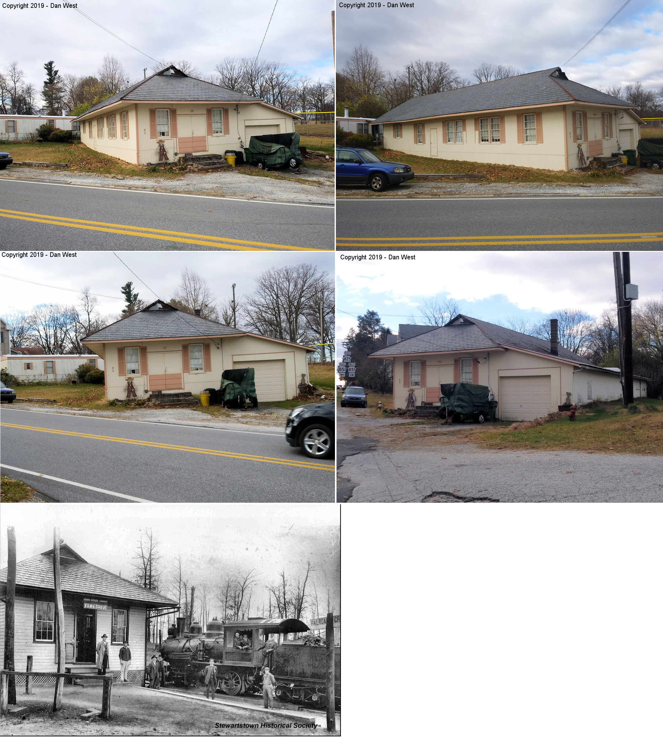
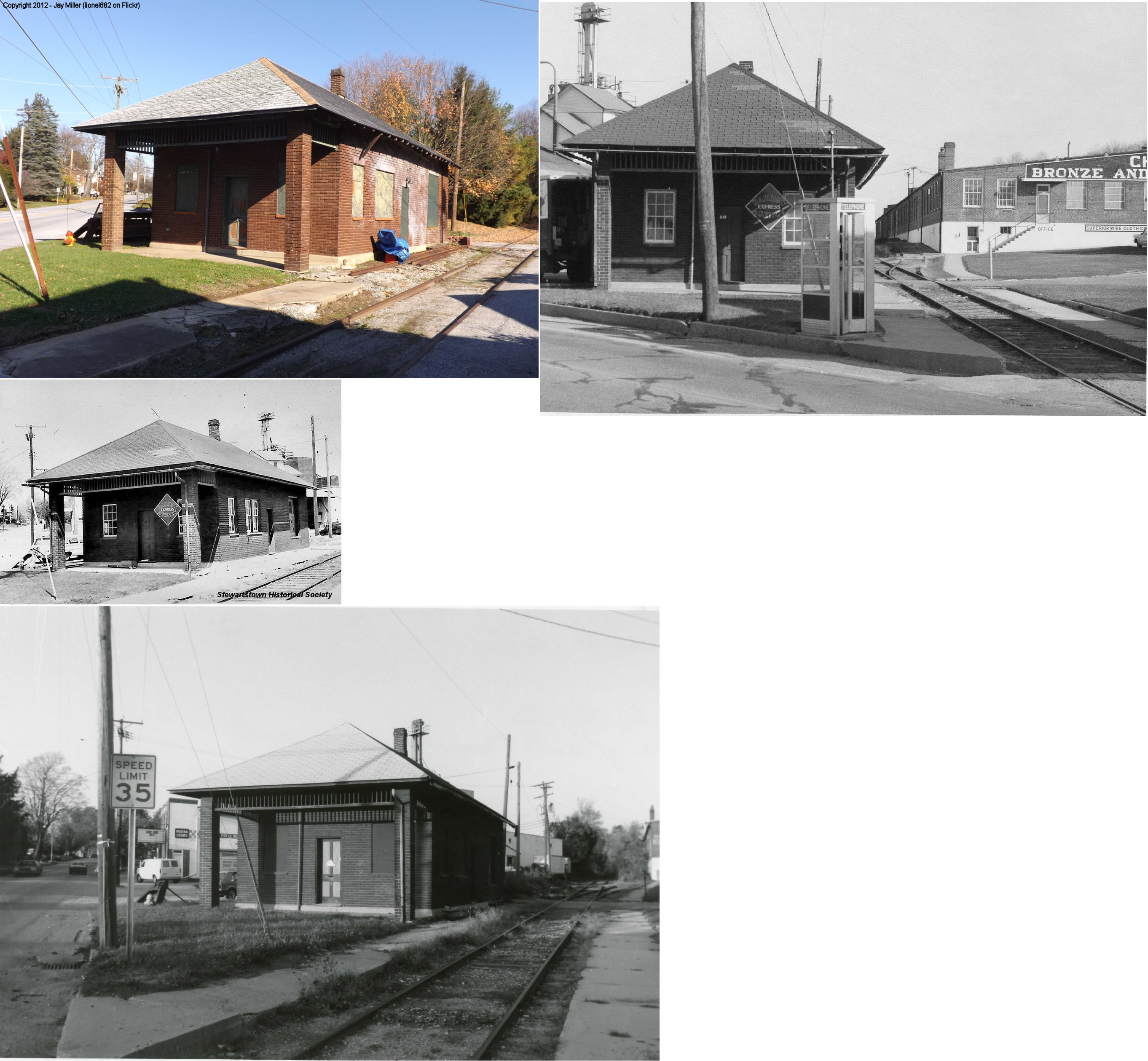
| Stewartstown |
|
Hill Street & Pennsylvania Avenue (GPS: 39.753377, -76.594371) |
C | RR/Museum | 1915 | In Use | Brick |
|
| Strickhouser |
|
2203 Strickhouser Road (GPS: 39.838401, -76.808428) |
F | Residence | 1853 | Gone | Brick |
|
| Tolna (Sheffer) |
|
2026 Windy Hill Road (Deer Creek and Windy Hill Roads) (GPS: 39.762268, -76.651400) |
C | Residence | 1886 | In Use | Wood |
|
| Woodbine | |
1270 Woodbine Road (GPS: 39.786614, -76.405744) |
P | Residence | ???? | Gone | Wood | |
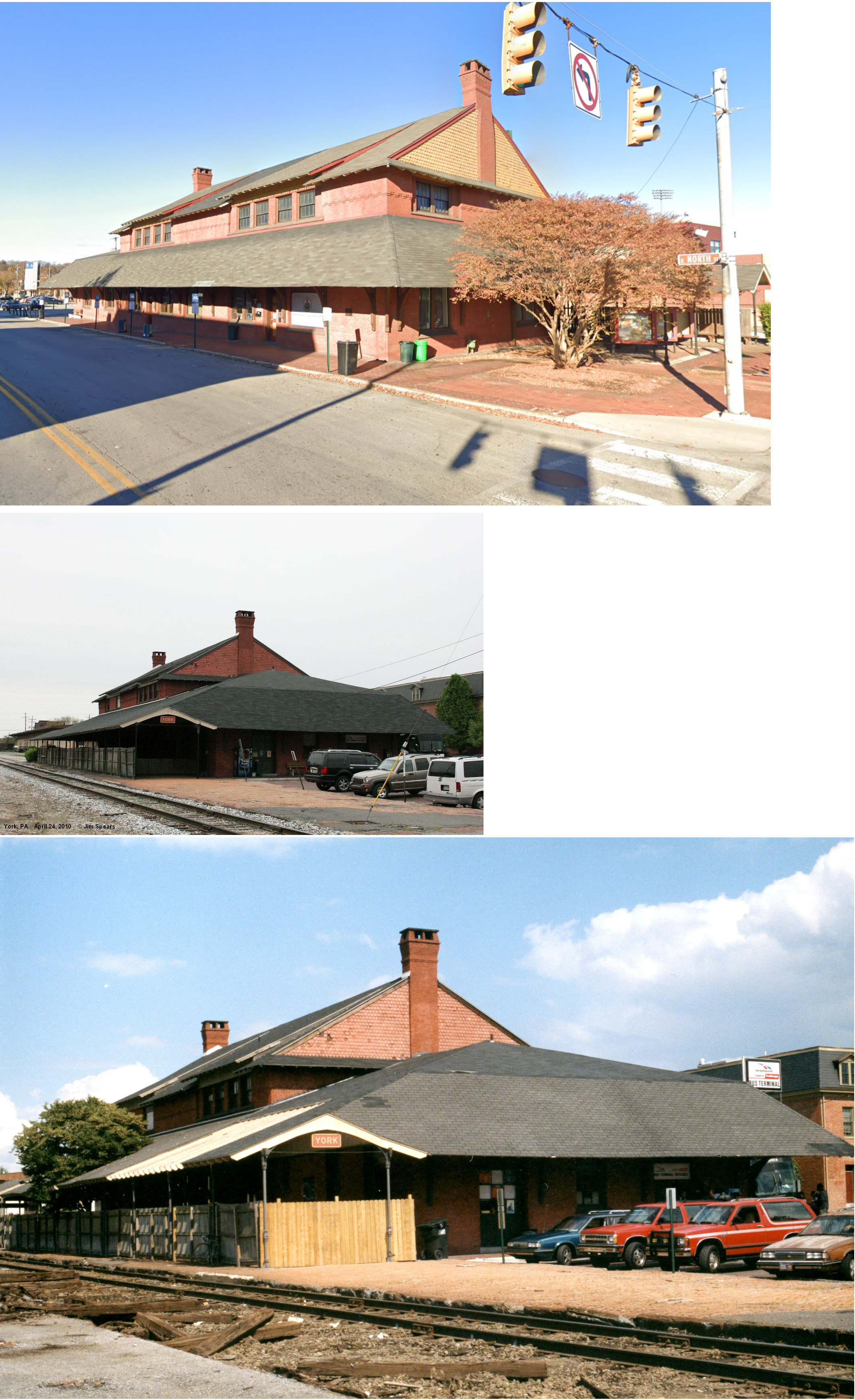
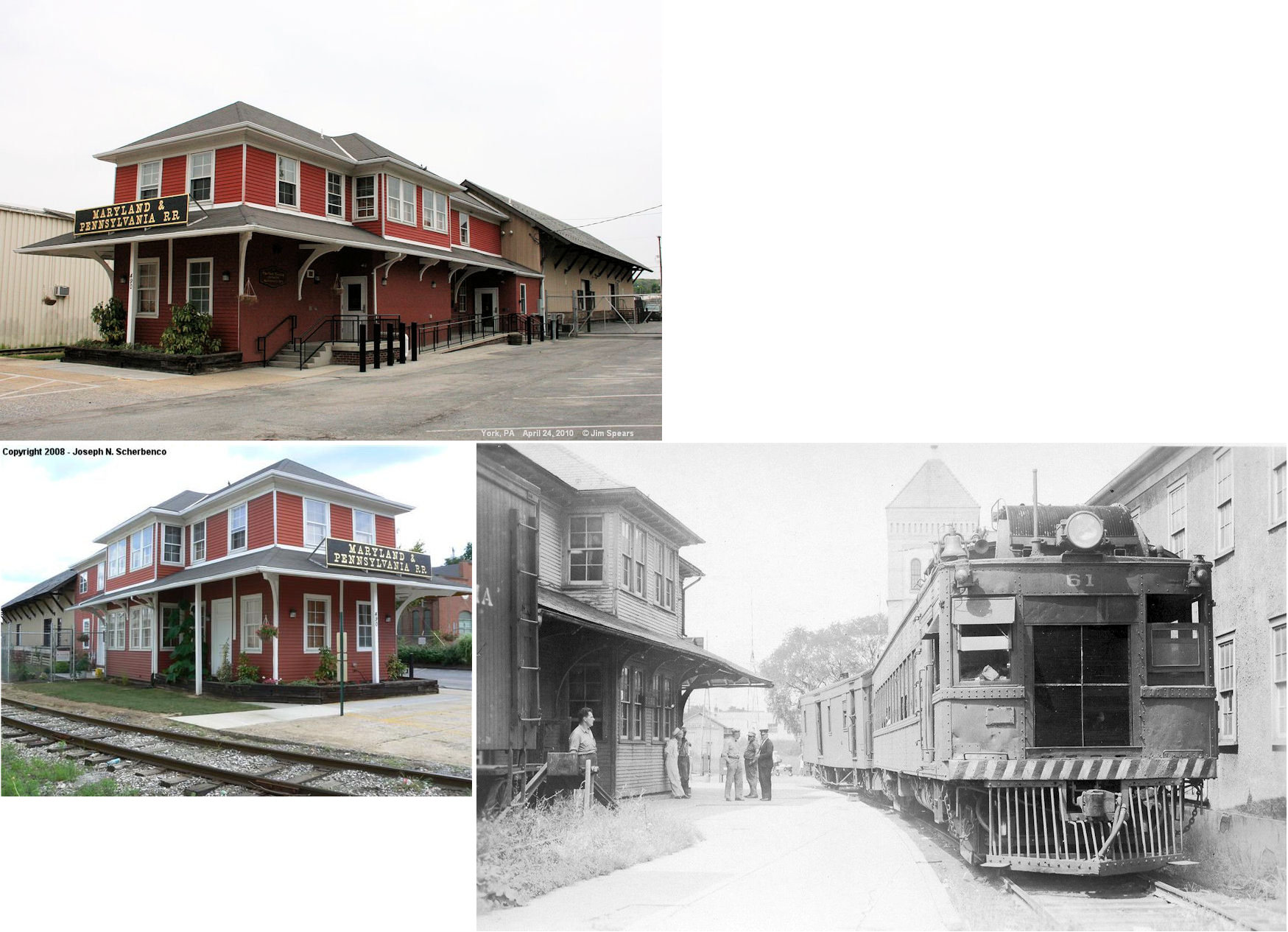
| York |
AND |
North & Duke Streets (GPS: 39.967106,-76.728355) |
P | Business | 1890 | In Use | Brick |
|
| York | |
North Street between Duke and North Queen Streets (GPS: 39.967533,-76.726906) |
F | Business | 1890 | In Use | Wood |
|
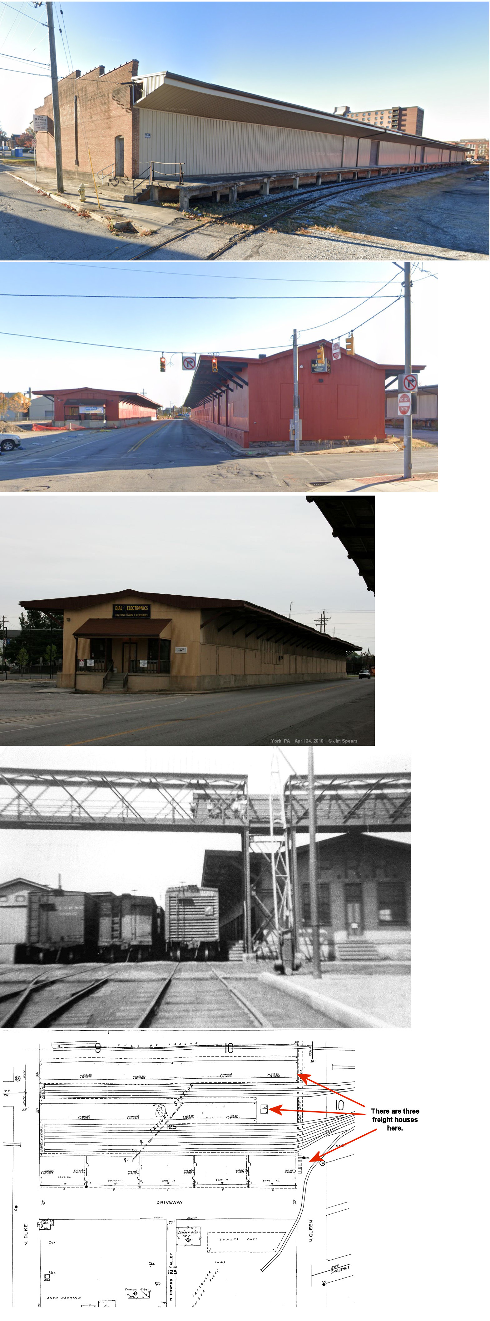
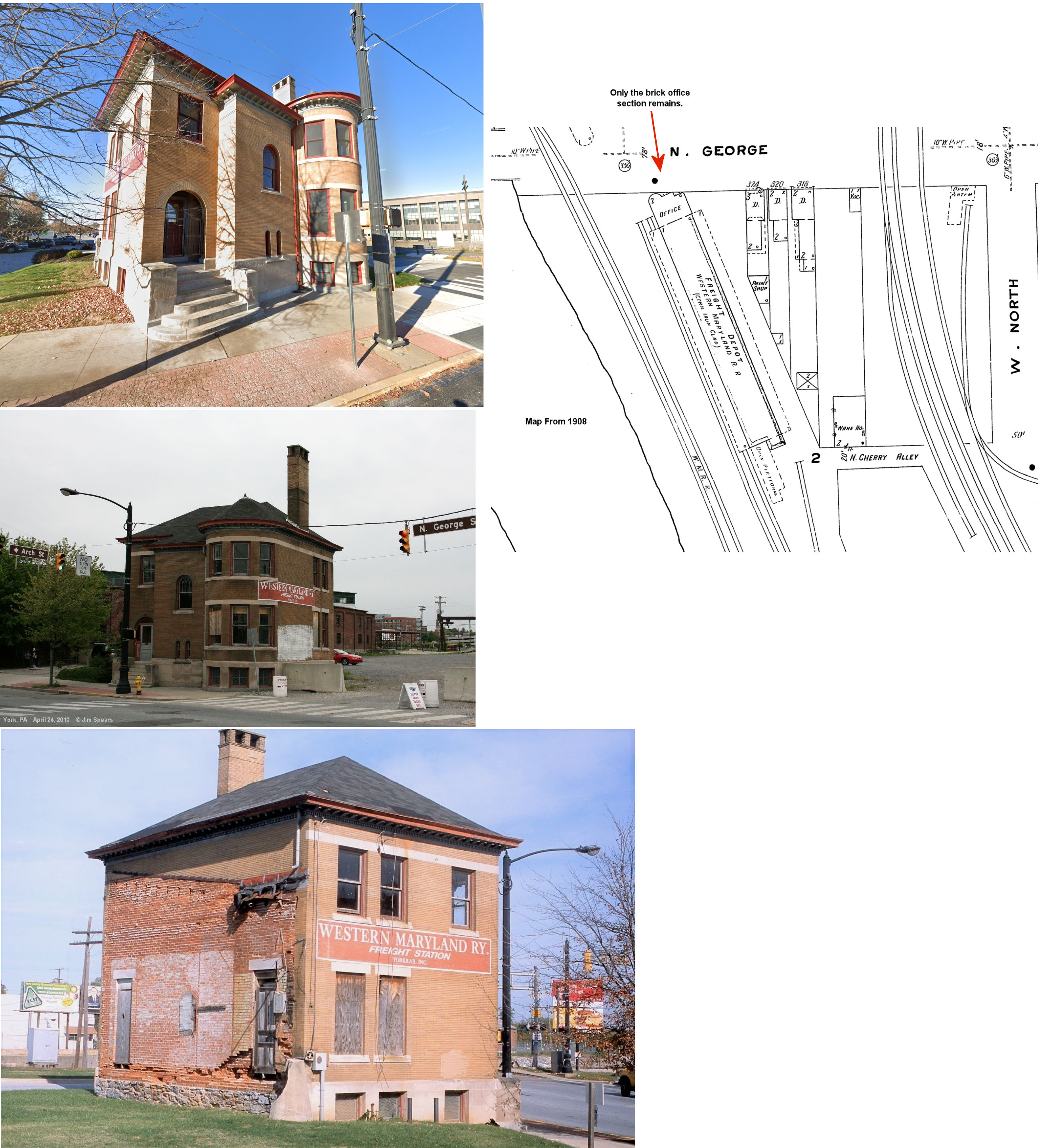
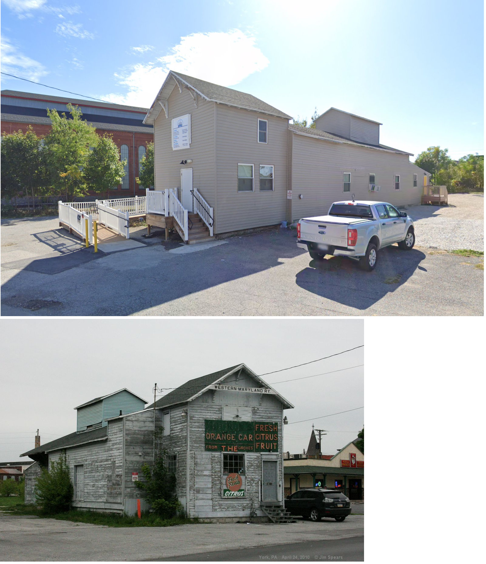
| York | |
George & Arch Streets (GPS: 39.967274,-76.730452) |
F | Business | 1893 | In Use | Brick |
|
| York | |
210 Roosevelt Avenue (GPS: 39.961997,-76.74061) |
F | Business | ???? | In Use | Wood | |
| York | |
490 East Market Street (GPS: 39.965728,-76.716663) |
C | Business | 1907 | In Use | Wood |
|
| STATIONS OF THE PAST | ||||||||
| Station Name |
Original Railroad |
Notes | ||||||
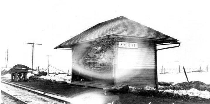
| Ambau |
|
There was a waiting shed here. It was near the intersection of York Road and Ambau Road, probably at GPS: 39.8503800, -76.8939618. | ||||||
| Anderson |
|
|||||||
| Anstine |
|
|||||||
| Bachman Valley junction |
|
This station was near where Park Road zig zags across the railbed. | ||||||
| Bair |
|
This station is shown on the 1900 PRR List of Stations & Sidings as well as the 1915 county map. | ||||||
| Ben Roy |
|
This station was off Camp Betty Washington Road near Old Dutch Lane until at least the mid-00s, but it appears to be gone now. Building was general store, post office, train station combo. It sat on a private drive. Can someone confirm that it was torn down? | ||||||
| Black Rock | |
There was a station here in 1876 when this was the Bachman Valley RR line. | ||||||
| Boring | |
|||||||
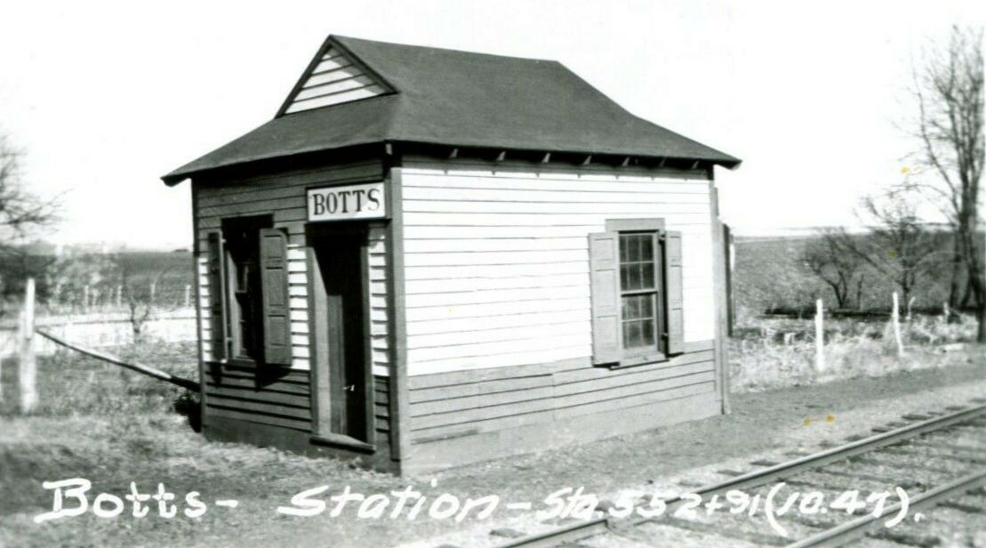
| Botts | |
This station was west of York. It was likely on Emigs Mill Road or South Salem Chruch Road. Does anyone know for sure? | ||||||
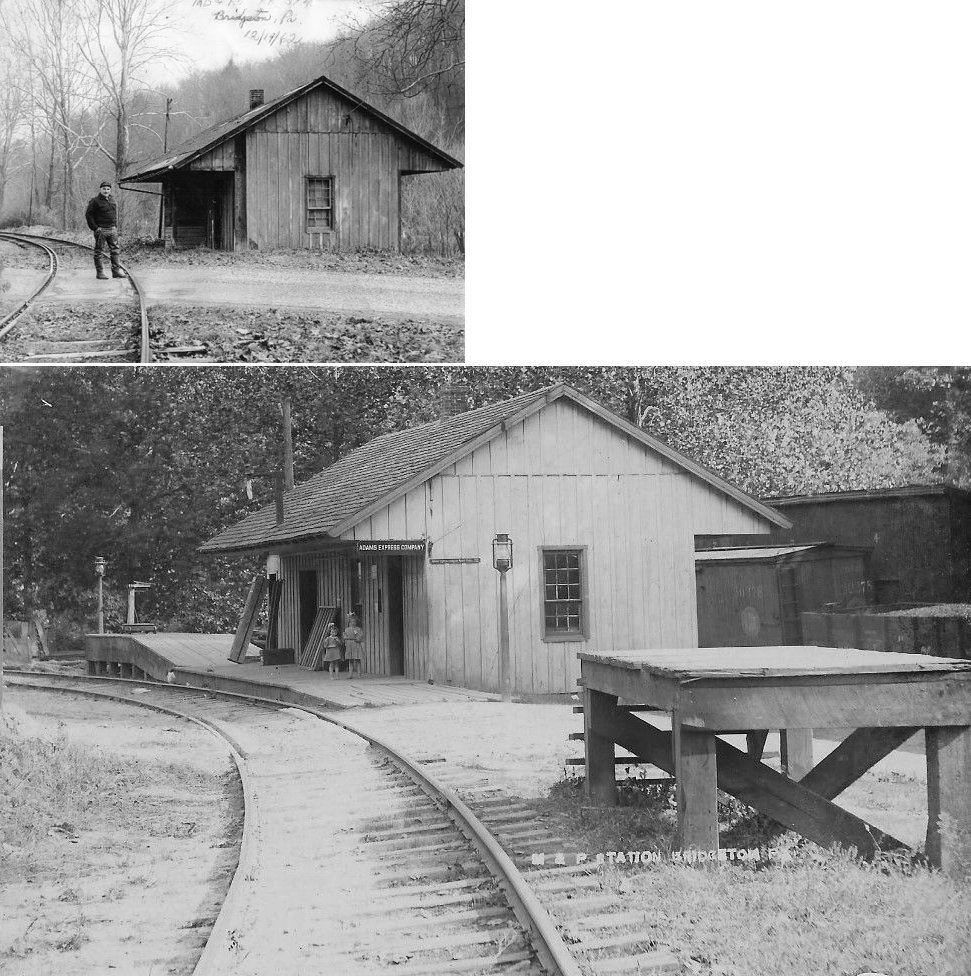
| Bridgeton | |
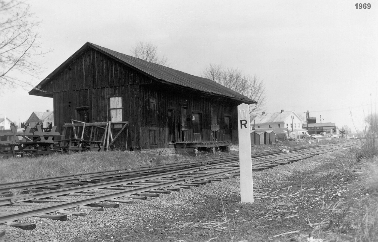
Photo is of Hack Eaton at station in 1962. This station was built in 1893 and torn down in 1969. | ||||||
| Brodbecks | |
This station was on the NE side of Blooming Grove Road (PA216) at GPS: 39.769516, -76.826483. | ||||||
| Brownton (Grove Sta.) |
|
This station was most likely in a general store here. The station closed in 1933. | ||||||
| Bruce | |
|||||||
| Bryansville | |
|||||||
| Campbell |
|
This station was on Campbell Road at approximately GPS: 39.991438, -76.627437. It is shown on the 1900 PRR List of Stations & Sidings, but is not shown on the 1915 county map. | ||||||
| Castle Fin | |
This cobination general store/station station burned down on January 5, 1904 due to an overheated stovepipe. Two adjacent buildings were also destroyed when the fire spread (according to The York Daily, January 7, 1904). | ||||||
| Cly |
|
|||||||
| Cold Spring |
|
|||||||
| Dallastown | |
This station was on the north side of East Maple Street east of North Walnut Street at GPS: 39.902200, -76.643426. It was built in 1893 and burned down in 1959. | ||||||
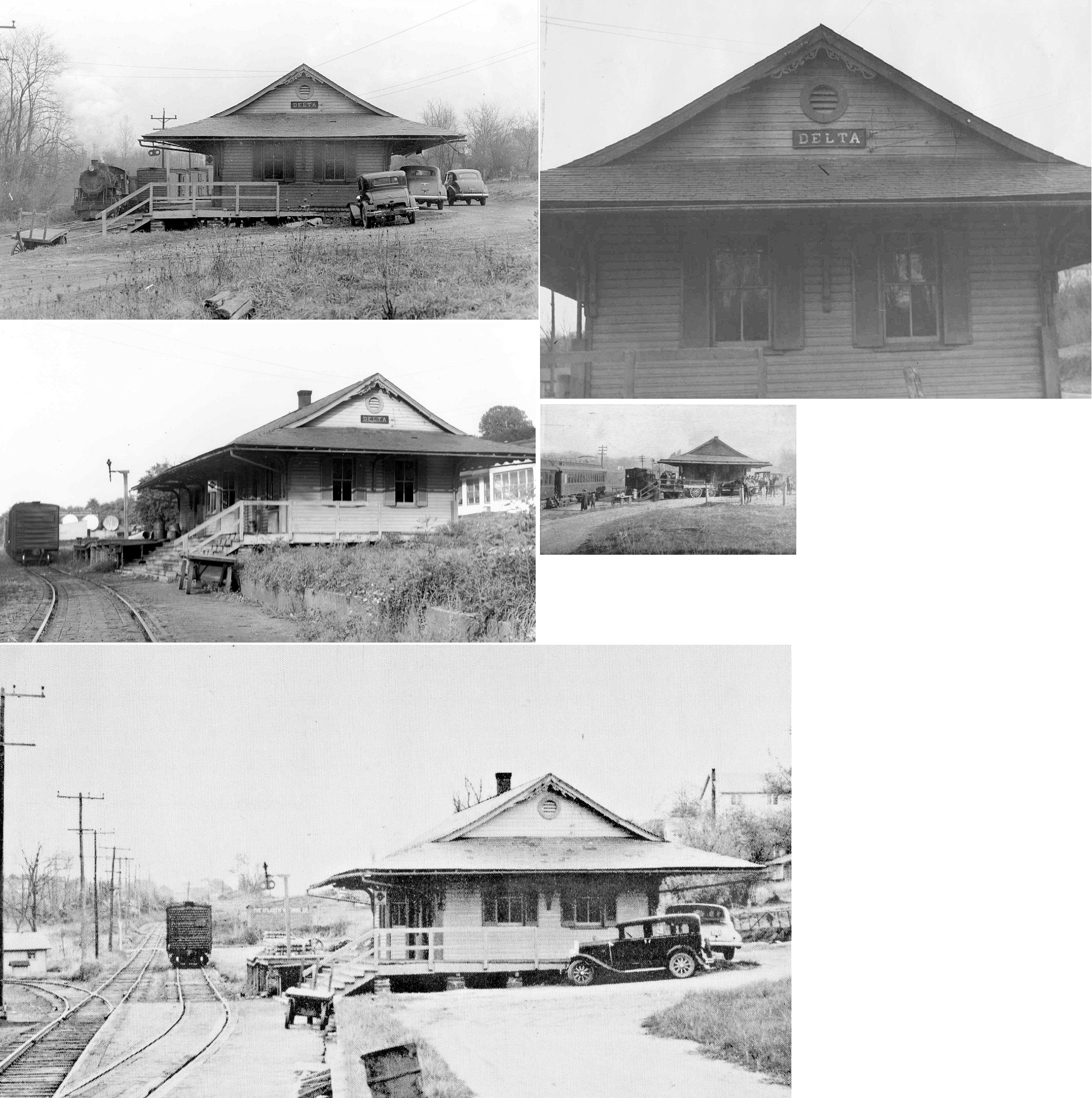
| Delta | |
The first station here was an old passenger coach converted into a station. The second station (still standing) was a combination general store/station. | ||||||
| Delta | |
The third station, a one-story combination depot, here was built in 1886. It was replaced in 1902. | ||||||
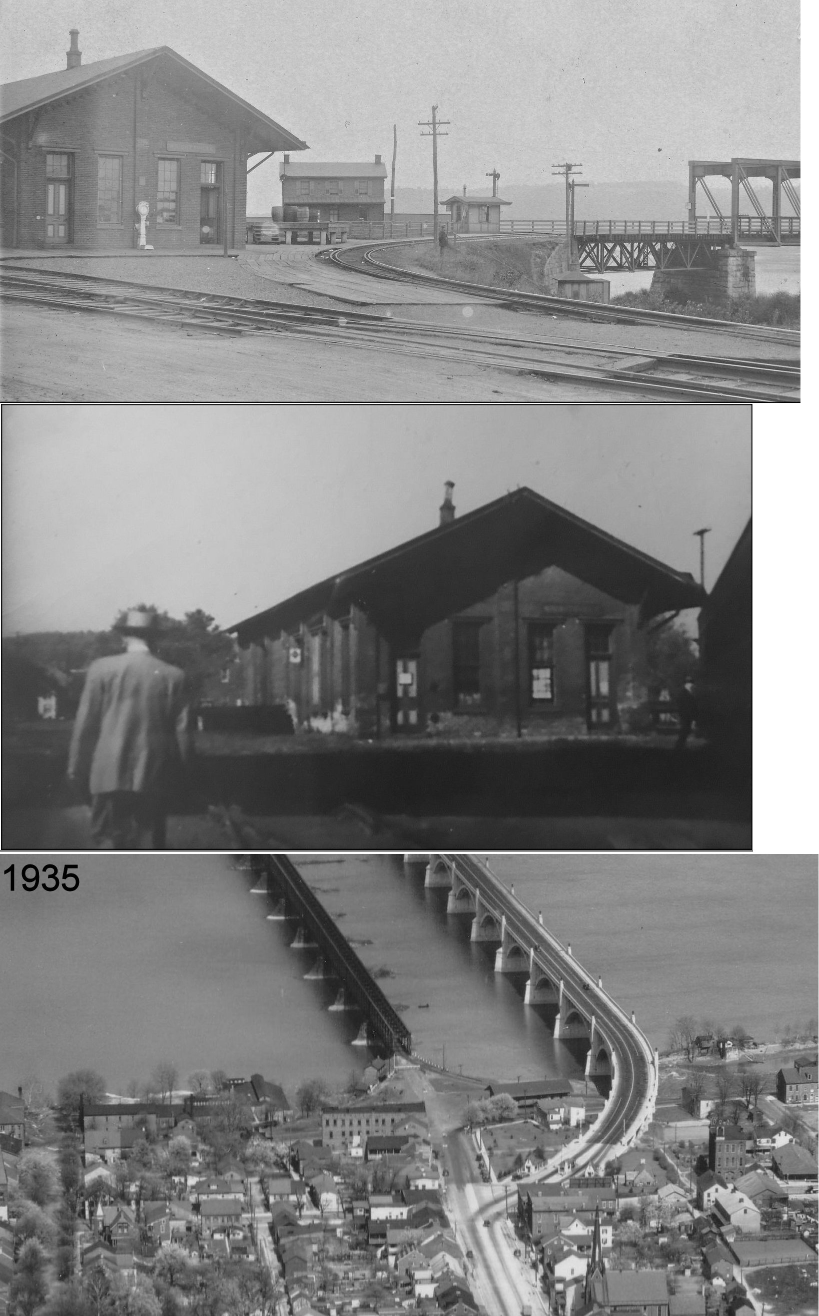
| Delta | |
This station, built in 1902, was between Bunker Hill Avenue and what is now Creamery Avenue (formerly Railroad Avenue) at approximately GPS: 39.726261, -76.330512. It burned down in 1967. | ||||||
| Delta | Baltimore & Lehigh |
The 1904 Sanborn insurance map shows a two-story station on the south side of Dooley Road just north of the PA/MA state line at approximately GPS: 39.721459, -76.336334. Was this the former location of the Peach Bottom RR station? I can't tell from the old maps if this station is the one that still exists at the location on Broad Street. It has the same profile as the station that's still standing, but at a different location. On this map the railroad is listed as the Baltimore & Lehigh RR. | ||||||
| Dillsburg |
 |
On the short Dillsburg branch of the Cumberland Valley RR (formerly the Mechanicsburg & Dillsburg RR). The station was on the NW corner of West Chruch Street and 2nd Street on the east side of the tracks at GPS: 40.111995, -77.037728. | ||||||
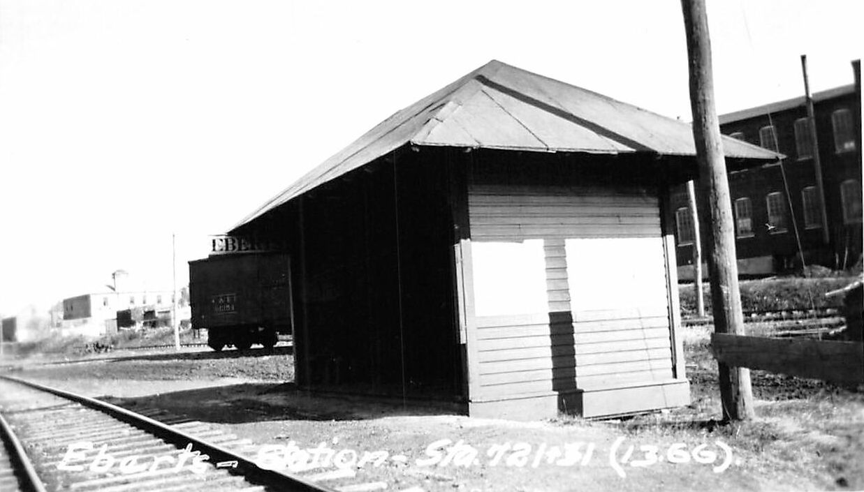
| Eberts |
|
This passenger shelter was likely on Eberts Lane in the industrial section of NE York in the vicinity of GPS: 39.975690, -76.706597. | ||||||
| Emigsville |
|
This station was east of Geroge Street (formerly Main Street) (PA181) at GPS: 40.020035, -76.727133. There was a large wooden platform that connected the station to the former Acme Wagon Company. | ||||||
| Enterprise |
|
|||||||
| Ewing Station |
|
This station was just west of Wrightsville where the railroad crossed Cool Creek Road. It is shown on the 1876 map. | ||||||
| Fawn Grove |
|
This appears to be an earlier combination station/general store. | ||||||
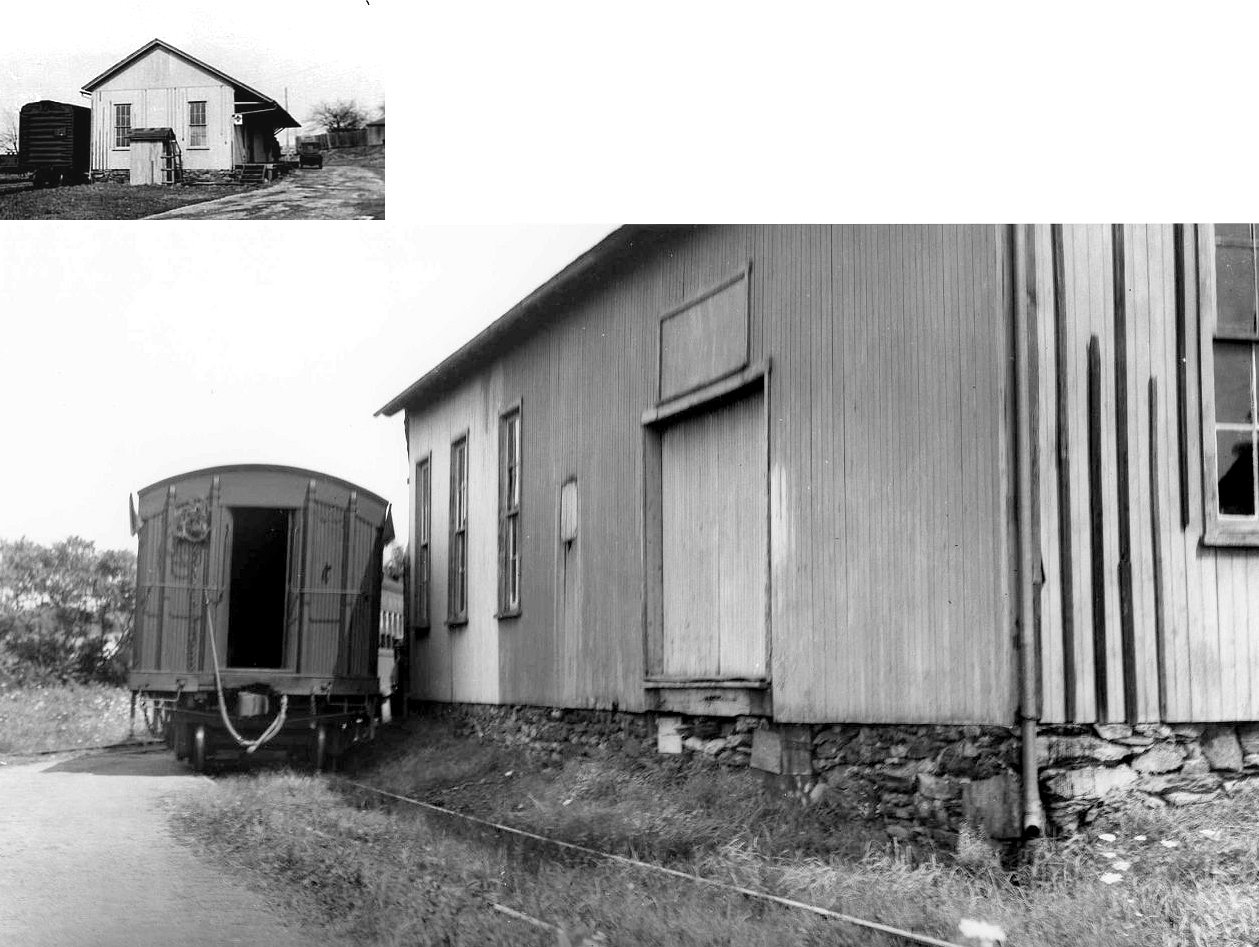
| Felton | |
This combination station was built in 1906, closed in 1953, and was torn down in 1979. The building pictured here is not an old station, but used to be a general store with an attached warehouse on the rear, both served by a siding off the Ma&Pa. | ||||||
| Fenmore | |
|||||||
| Gemmill |
|
|||||||
| Gitts Run |
|
This station is shown on the 1900 PRR List of Stations & Sidings as well as the 1915 county map. It was just NE of Hanover. | ||||||
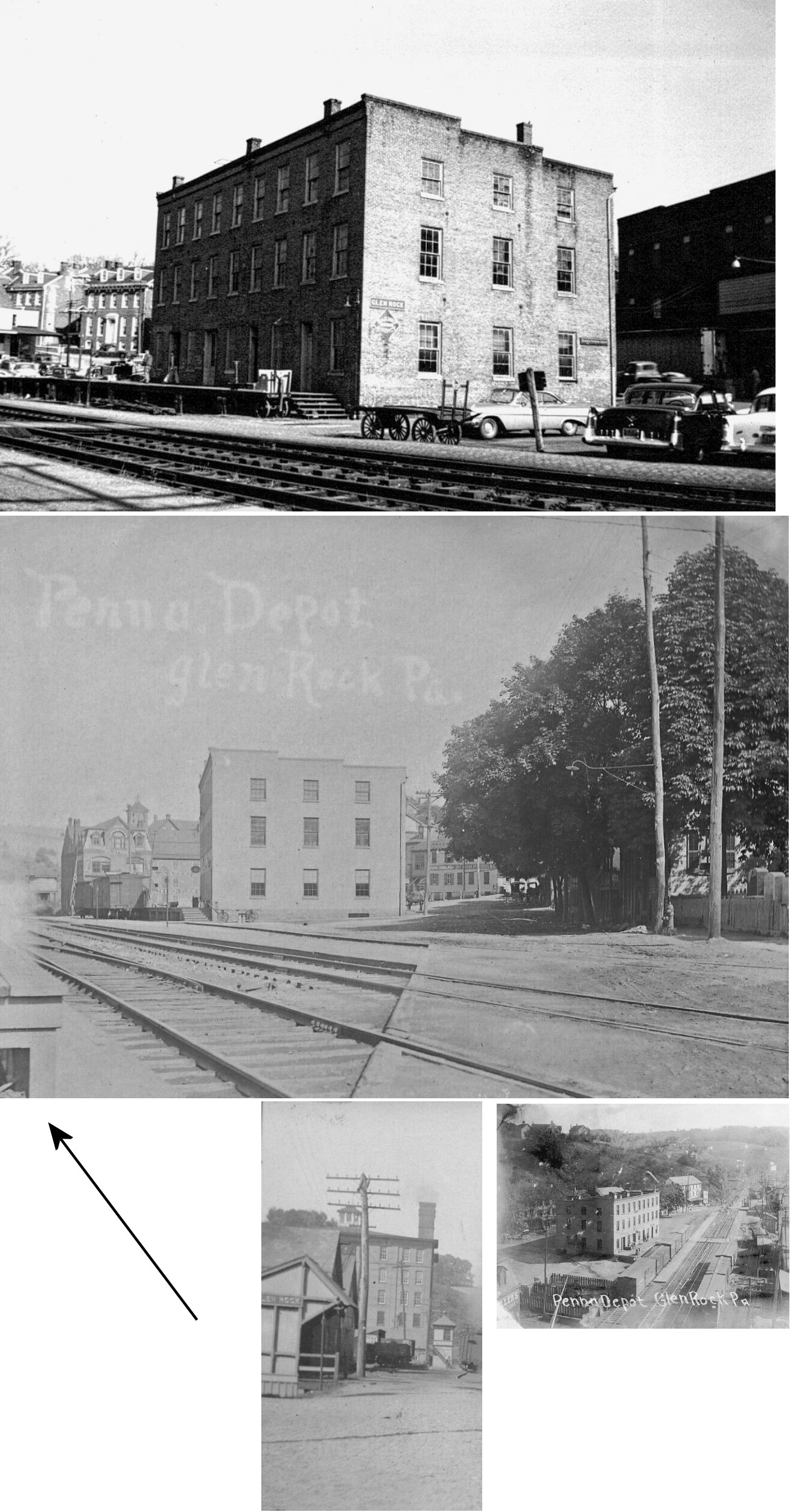
| Glen Rock |
|
This three-story brick station was on the south side of Main east of Water Street on the north side of the tracks at GPS: 39.794266, -76.731857. | ||||||
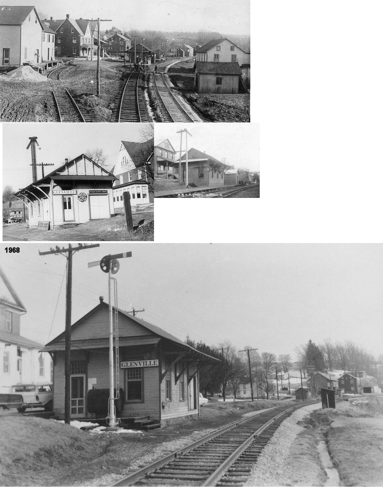
| Glenville (Glenmore) |
|
There was a station here in 1876 when this was the Bachman Valley RR line. | ||||||
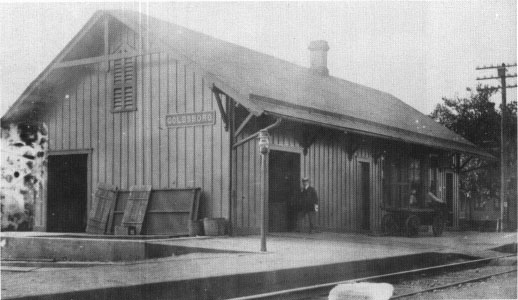
| Goldsboro (Etters) |
|
In 1876 the station agent here was Benjamin F. Kirkwood. It was located on the west side of the tracks between Pennsylvania Avenue and Zeigler Avenue at GPS: 40.154061, -76.749084. The station was torn down around 1960. | ||||||
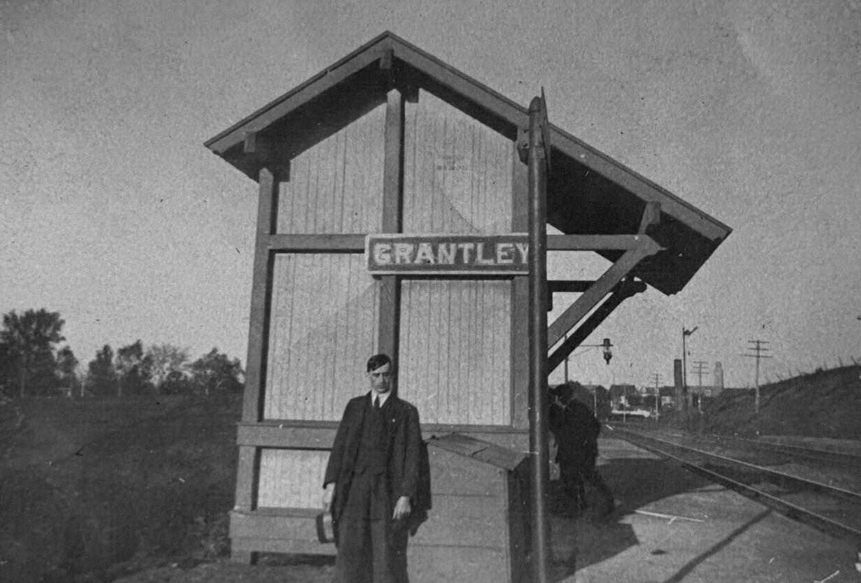
| Grantley |
|
This station is shown on the 1900 PRR List of Stations & Sidings as well as the 1915 county map. | ||||||
| Graybill |
|
This station is shown on the 1900 PRR List of Stations & Sidings as well as the 1915 county map. | ||||||
| Hanover |
 |
Ther Hanover & York RR and Littlestown RR may have shared a station here in the early years. A building is shown on maps from 1876 at the site of the existing station on Railroad Street and Library Place. | ||||||
| Hanover |
|
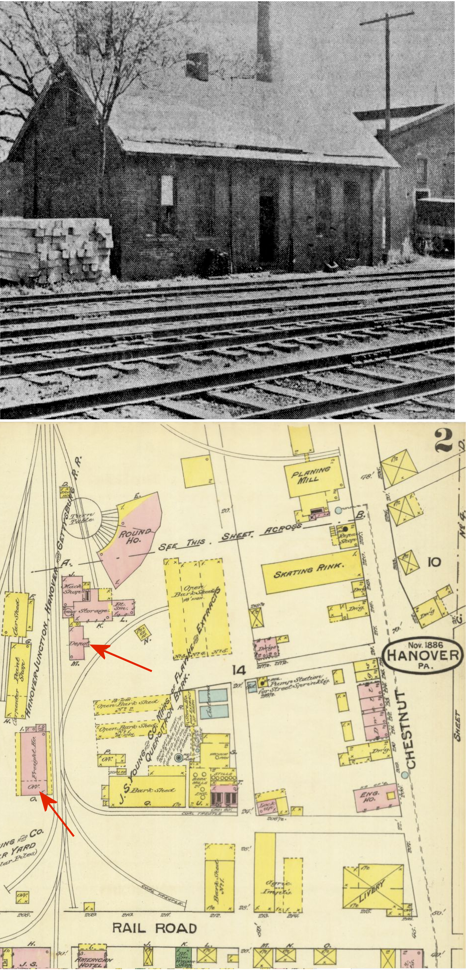
Ther Hanover Junction, Hanover & Gettysburg (HJH&G) Railroad had its facilites (including a roundhouse and shops) on the NE side of Railroad Street. The original brick station here was the site of a two-sentence Abraham Lincoln speech from the back of a train in 1863 on his way to deliver the Gettysburg Address. The station was on the NE side of Railroad Street at approximately GPS: 39.804278, -76.984916. It likely went out of service in 1889, but, likely due to its proximity to the RR shops, it stood until it was torn down in 1953 (Sunday News, 11-15-1953). The original freight station (also brick) stood near where the extant passenger station stands today. | ||||||
| Hanover |
|
The original passenger station was on the SW side of Carlisle Street (GPS: 39.803571, -76.987097). It appears on the 1886 town map, but not on the 1896 map after the union station was built. | ||||||
| Hanover |
|
There was a freight station on the NE side of High Street (GPS: 39.802215, -76.989457). | ||||||
| Hellam (Hersheys) |
|
The original Hellam Y&W station was on the north side of the tracks on the east side of Yorkanna Road (South Broad Street) at GPS: 39.998740, -76.603525. The station in the photo may be the original, or a later NCRR station. The station was originally named "Hersheys," but the name was changed sometime between 1876-1889. | ||||||
| Heistand (Summit) |
|
This station is shown on the 1900 PRR List of Stations & Sidings as well as the 1915 county map. It was on Mt. Zion Road at approximately GPS: 39.983366, -76.664640. | ||||||
| High Rock | |
Like several other stations along the line, this was a combination general store/station. The station closed in 1949. | ||||||
| Iron Ridge |
|
This station is shown on the 1900 PRR List of Stations & Sidings as well as the 1915 county map. | ||||||
| Jacobs Mills Station |
|
This was an early station on the Hanover & York Railroad. This station is shown on the 1900 PRR List of Stations & Sidings as well as the 1915 county map. | ||||||
| Jefferson (Codorus) |
|
|||||||
| Keeney |
|
|||||||
| Kisiner |
|
|||||||
| Larue |
|
There was a freight station here on Boose Road at approximately GPS: 39.820476, -76.760510. | ||||||
| Manifold |
|
|||||||
| Maple Hill |
|
|||||||
| Marsh Run |
|
In 1876, the station was also the hotel here. | ||||||
| Martin |
|
This station is shown on the 1900 PRR List of Stations & Sidings as well as the 1915 county map. | ||||||
| Menges Mills Station | |
|||||||
| Menges Mills |
|
This station is shown on the 1900 PRR List of Stations & Sidings as well as the 1915 county map. | ||||||
| Muddy Creek Forks | |
Prior to the station/general store that is still standing, there was an earlier station general store combo here. That building was built in the late 1840s. | ||||||
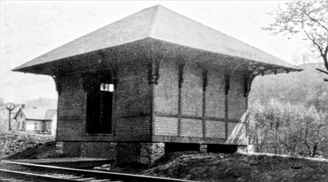
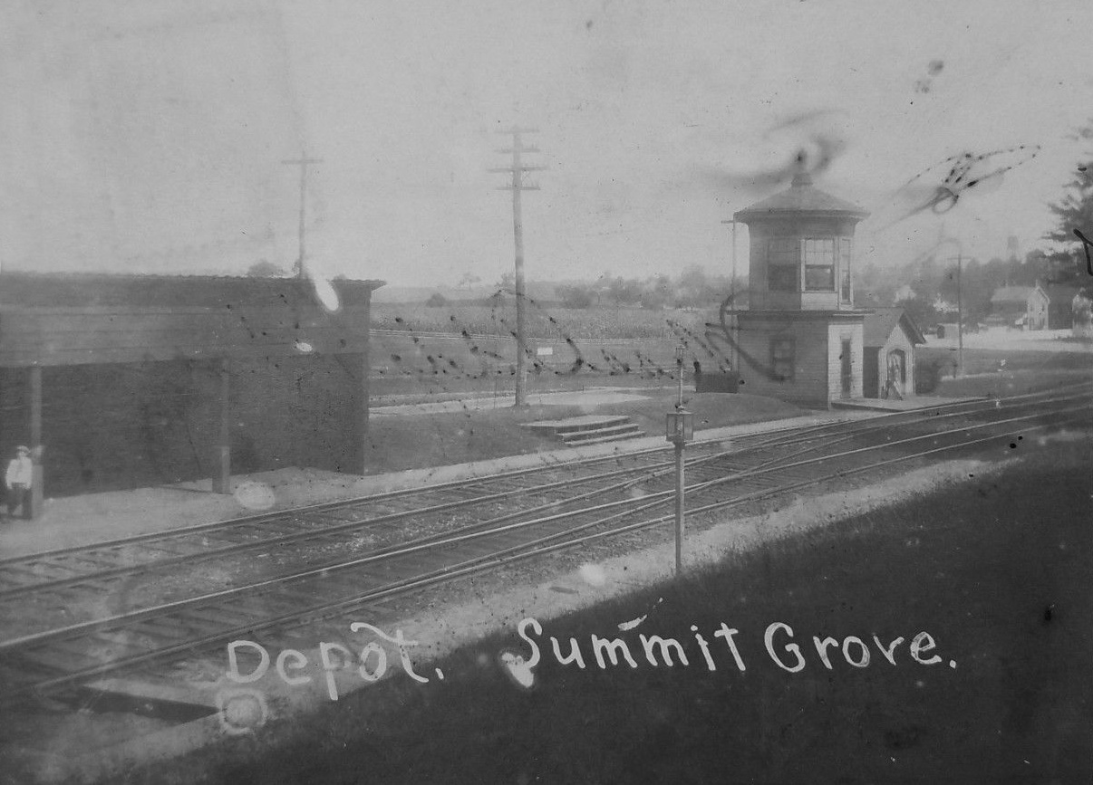
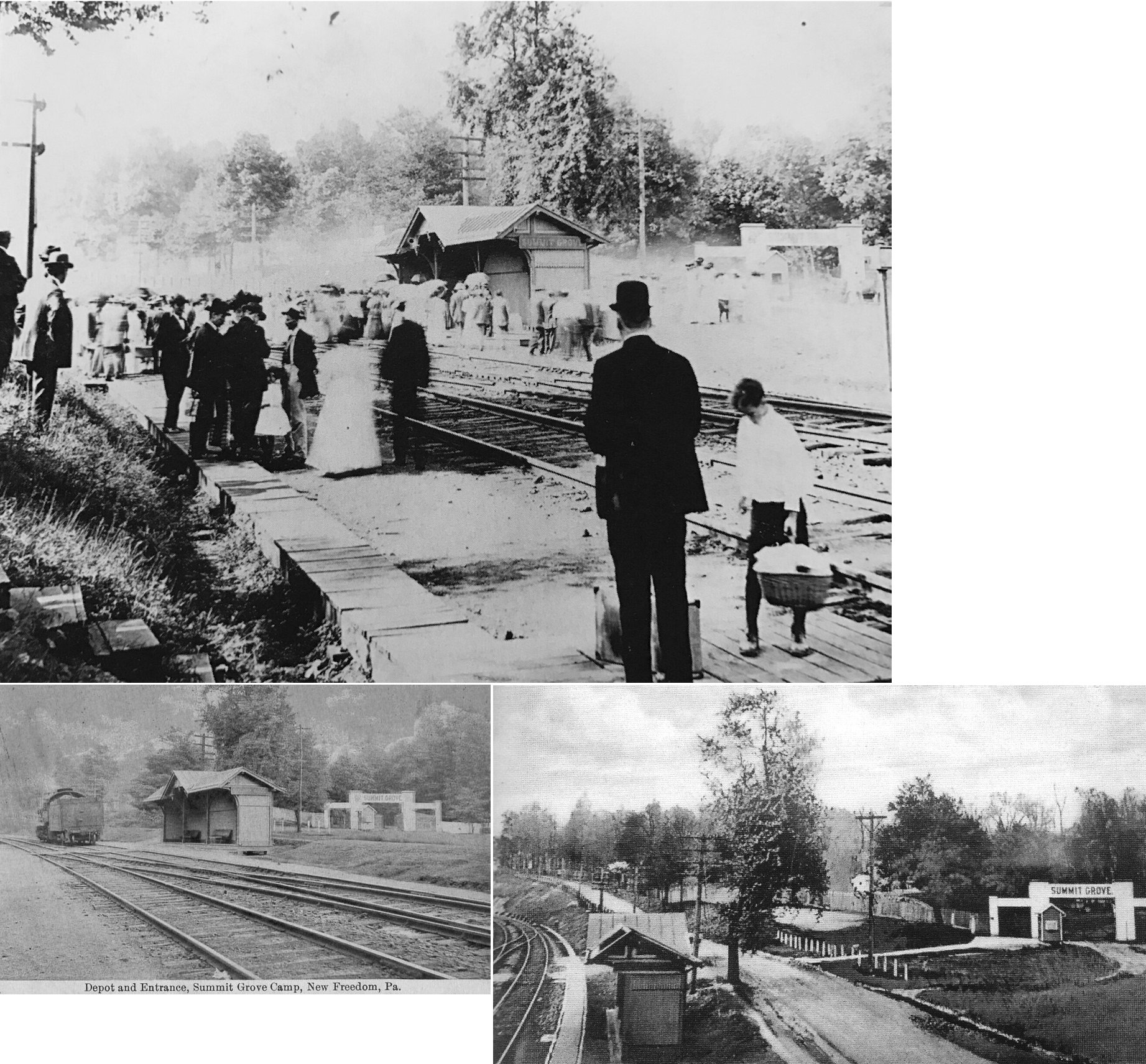
| New Freedom (Summit Grove) |
|
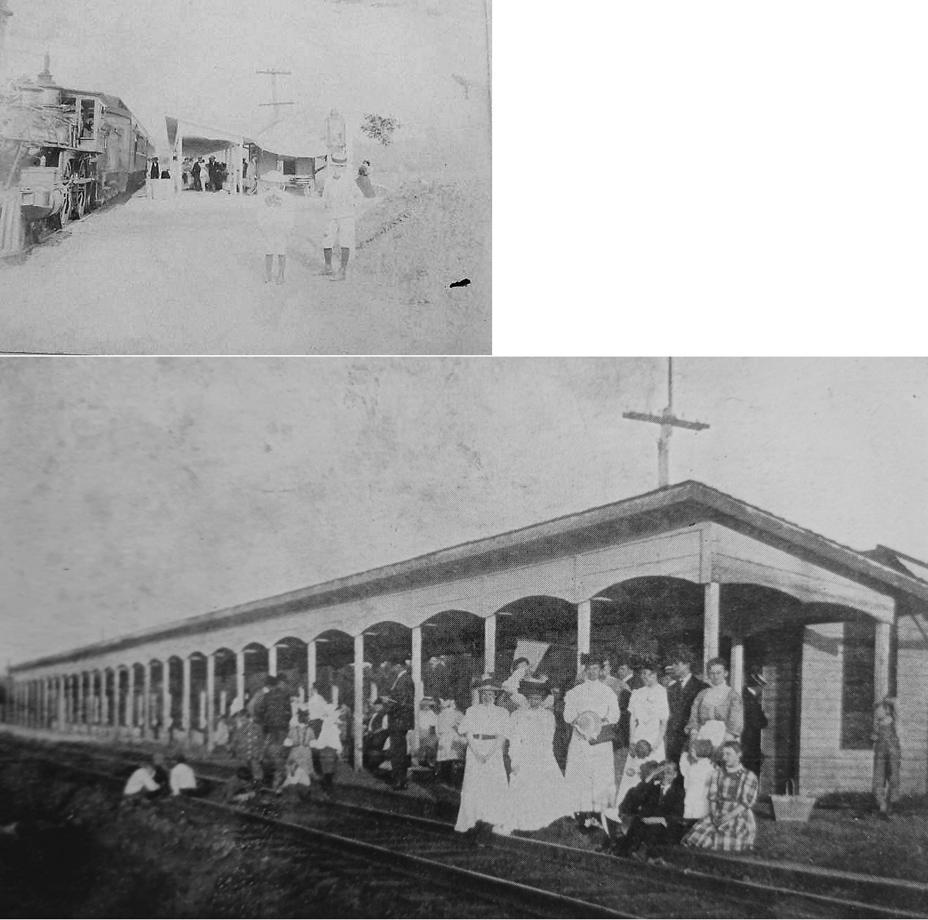
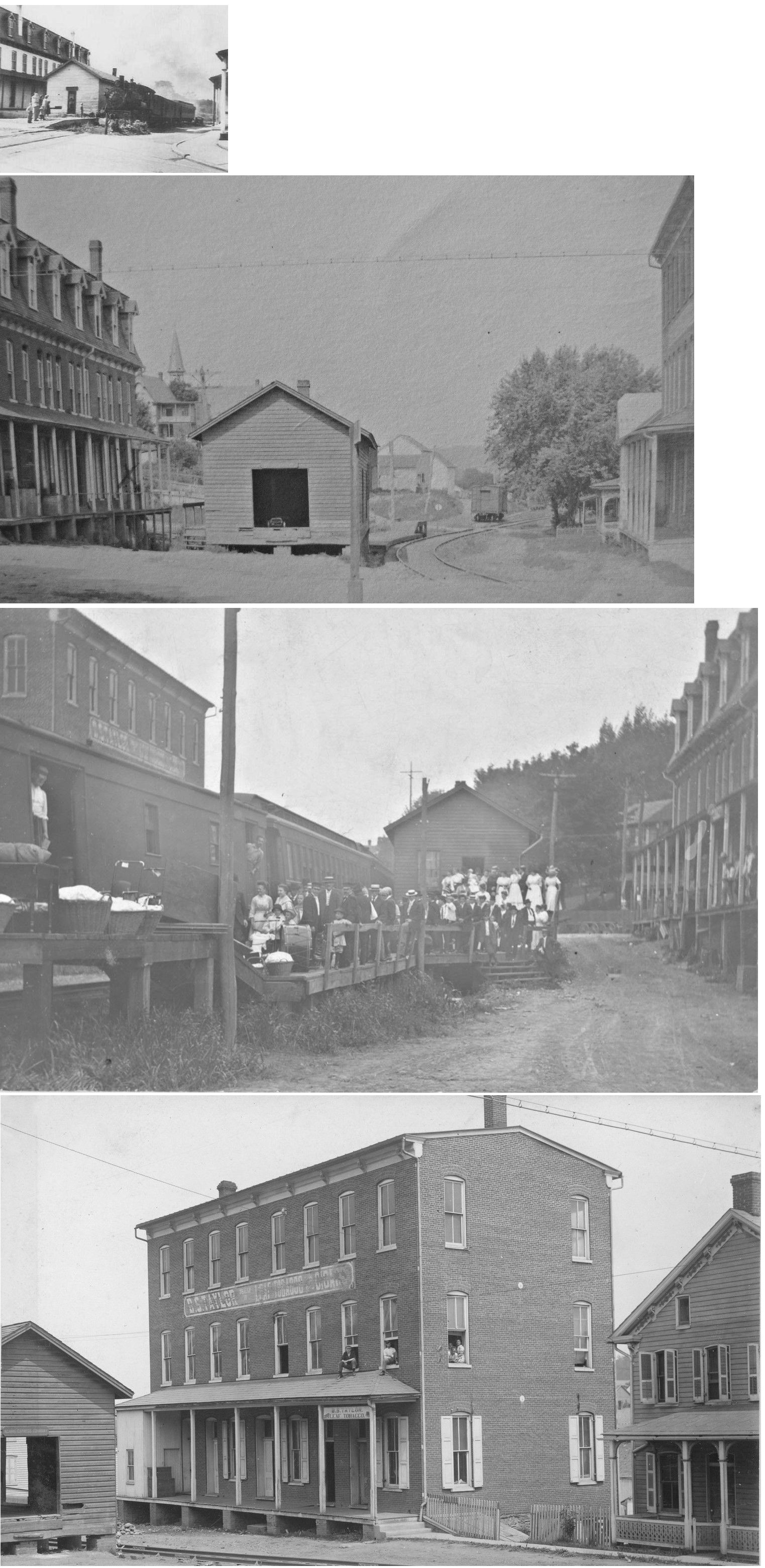
This shelter-type station served the Summit Grove Camp & Retreat that is in the southern part of New Freedom. The station was near the intersection of South Front Street and Logan Drive in the vicinity of GPS: 39.733600, -76.704662. Also shown in the photo is NF tower. | ||||||
| New Freedom (Summit Grove) |
|
This was the second-generation station at Summit Grove at approximately the same location as the older one listed above. | ||||||
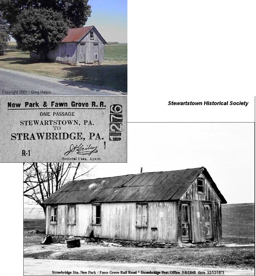
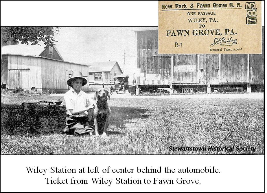
| New Park |
|
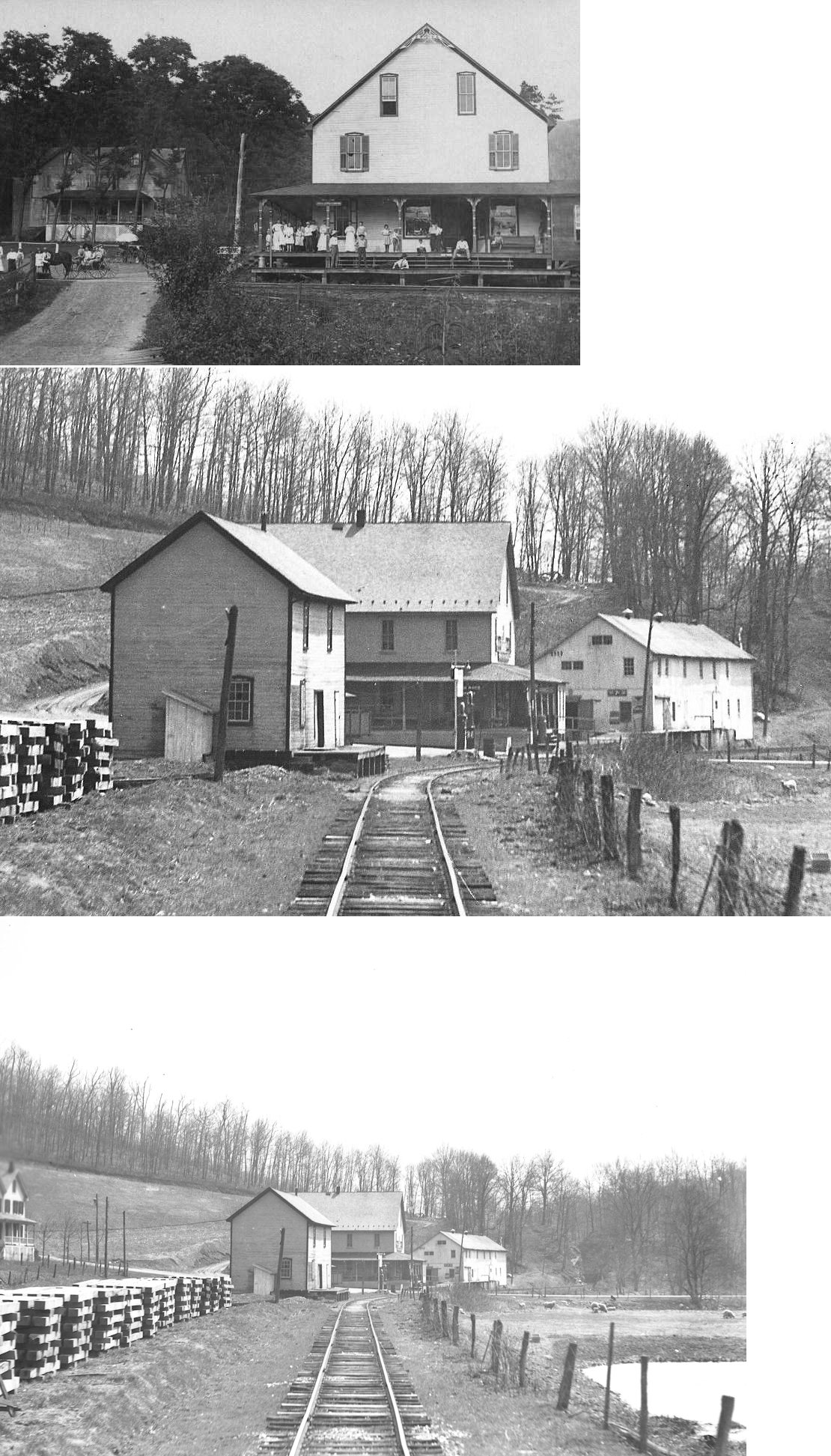
The New Park station was part of the post office and store complex on the premises of Joseph Gailey. It served as the depot and operating headquarters for the NP&FG RR. The railroad opened for business on Thursday, August 9, 1906. It merged with Stewartstown RR in 1923 and was abandoned in the 1930s. The New Park & Fawn Grove connected the Stewartstown and continued in a southeastern direction roughly parallel more or less alongside local roads for a distance of nine miles, passing through the villages of Manifold, Maple Hill, Gemmill, Wiley, Strawbridge, New Park, Kisiner and Fawn Grove. Although abandoned in the mid-1930s, much of the grading is still visible in places today. | ||||||
| Ore Valley | |
This station was on Springwood Road south of Camp Betty Washington Road (GPS: 39.930394,-76.654927). It was demolished on July 7, 2012 after serving as a residence. | ||||||
| Plank Road Station |
|
This was the first station SE of York. I believe it was in the vicinity of Mt. Rose Avenue. | ||||||
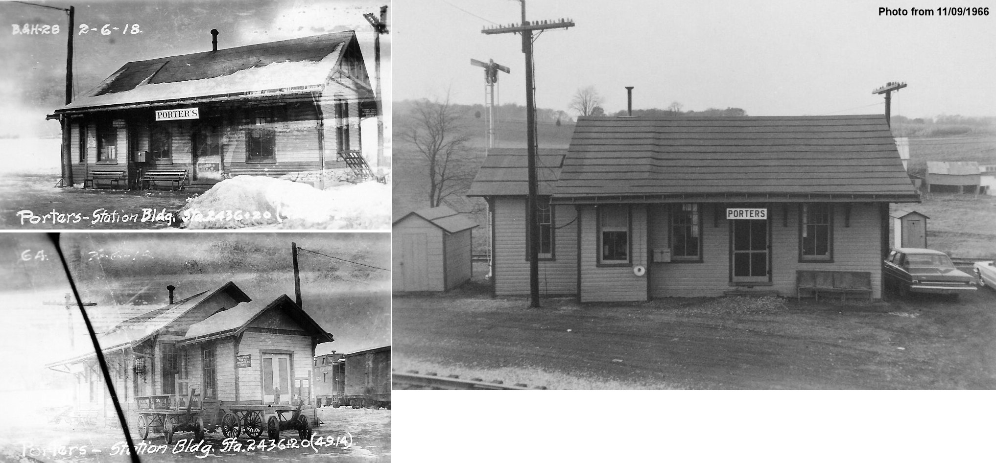
| Porters Siding |
|
|||||||
| Railroad |
|
The first station here was on the north side of Main Street on the east side of the tracks. | ||||||
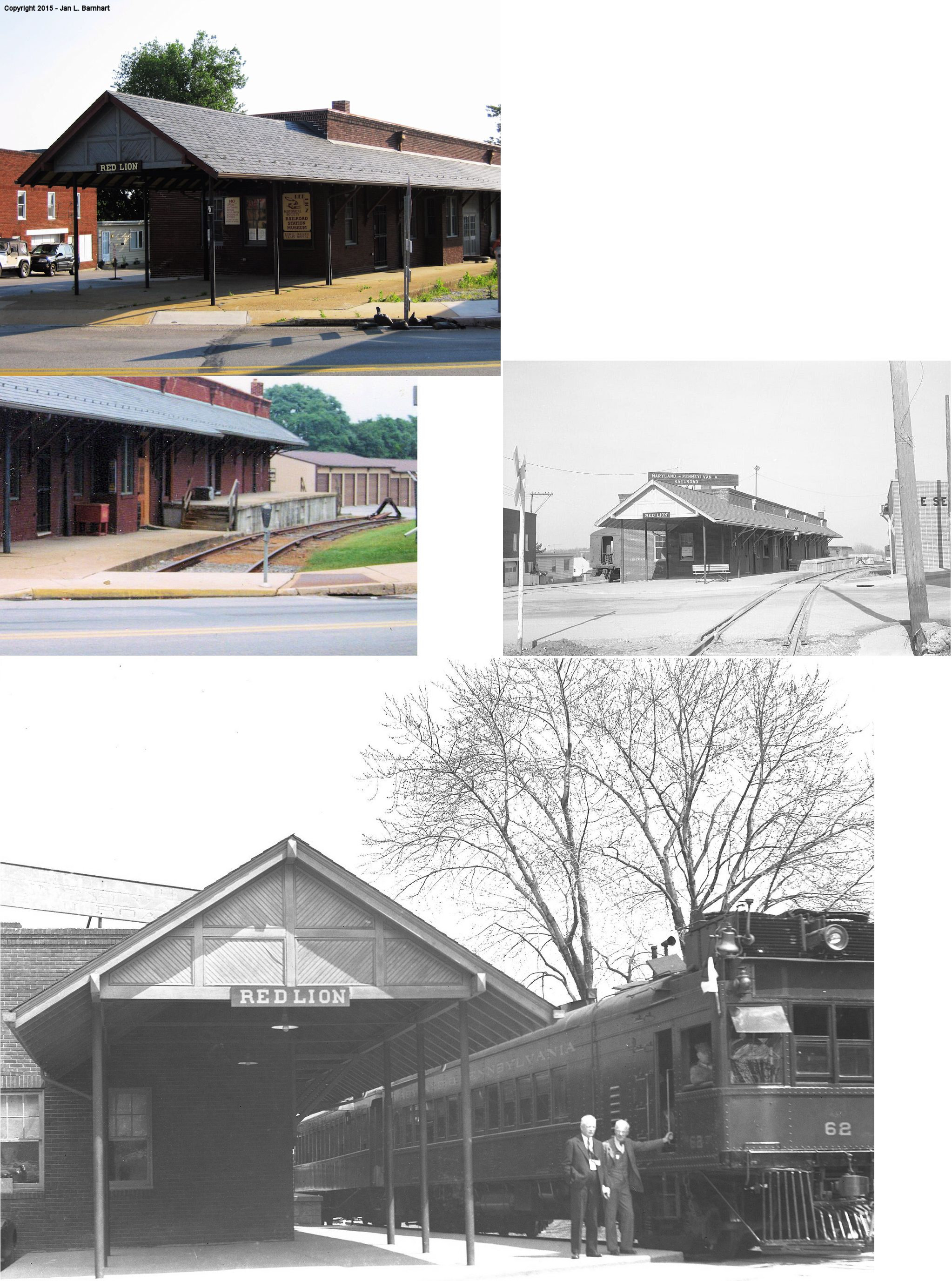
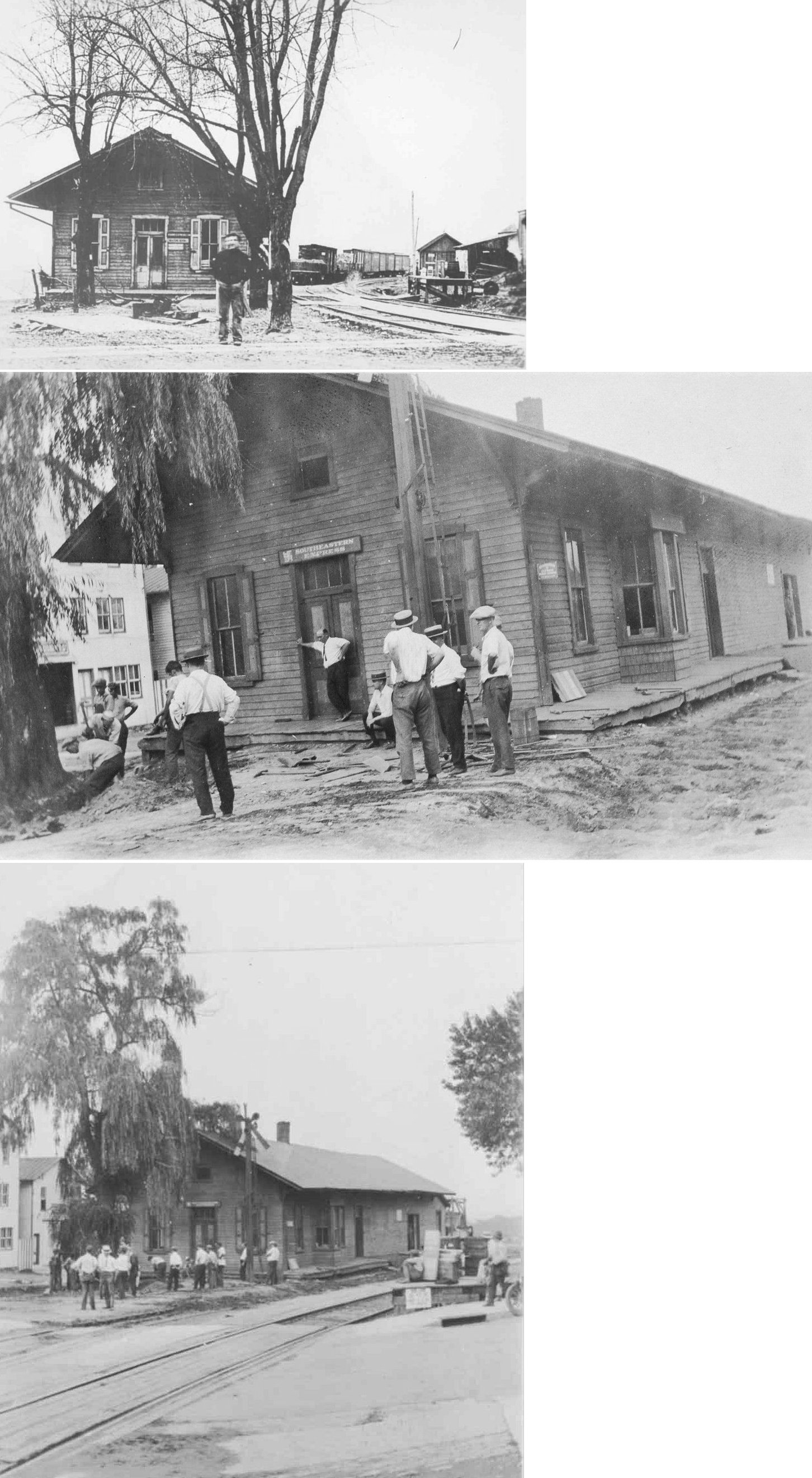
| Red Lion |
|
The first station here was a combination general store/station that was built in 1875. It burned down in 1895 and was quickly replaced with an identical building at the same site. This second station was then torn down in 1925 in order for the new (still standing) station to be built at the same location on Main Street. | ||||||
| Reimolder |
|
|||||||
| Rockburn |
|
This station was located east of North Hills Road on the south side of the tracks in the vicinity of GPS: 39.978195, -76.692113. | ||||||
| Seitzland |
|
This station was on the north side of West Clearview Drive on the east side of the tracks at GPS: 39.785554, -76.722562. This station is shown on the Sanborn maps for Glen Rock. | ||||||
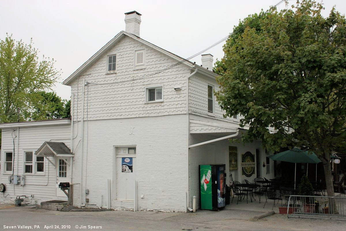
| Seven Valleys (Smyser Sta.) |
|
Freight station. | ||||||
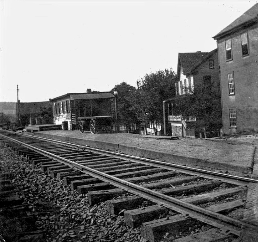
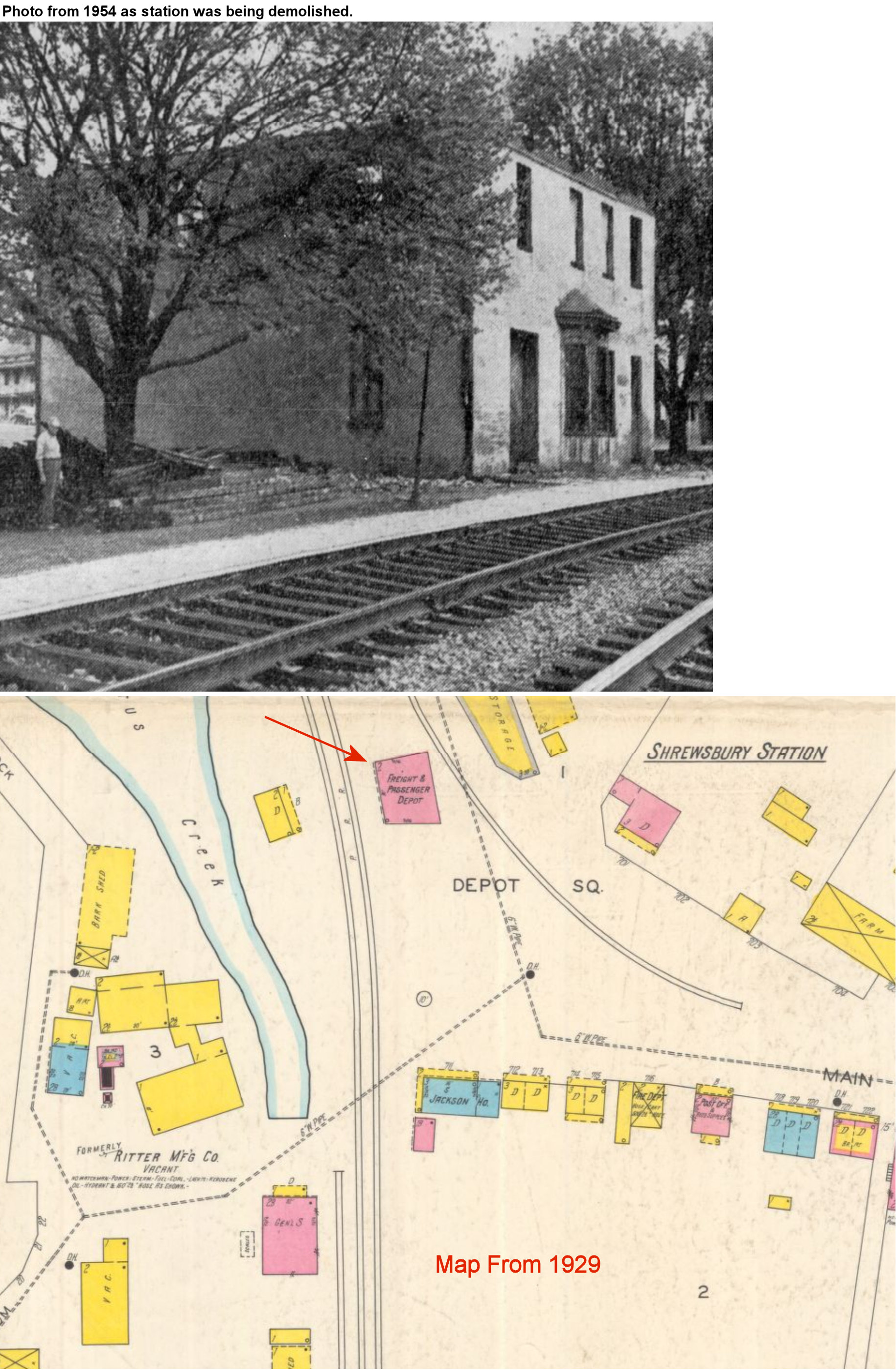
| Shrewsbury Station (Railroad) |
|
This 2-story brick station, built around 1854 was on the north side of Main Street on the east side of the tracks at GPS: 39.761078, -76.699496. It may have also been called "Strasburg" on early timetables. It went out of service in 1942 and was torn down in 1954 (Sunday News, 4-25-1954). | ||||||
| Smith
Station (Penn Grove Camp) |
|
This was the station for passengers traveling to/from Penn Grove Camp (originally known as Camp Pamadeva). | ||||||
| South Branch |
|
There was a station here in 1876 when this was the Bachman Valley RR line. | ||||||
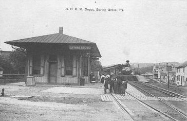
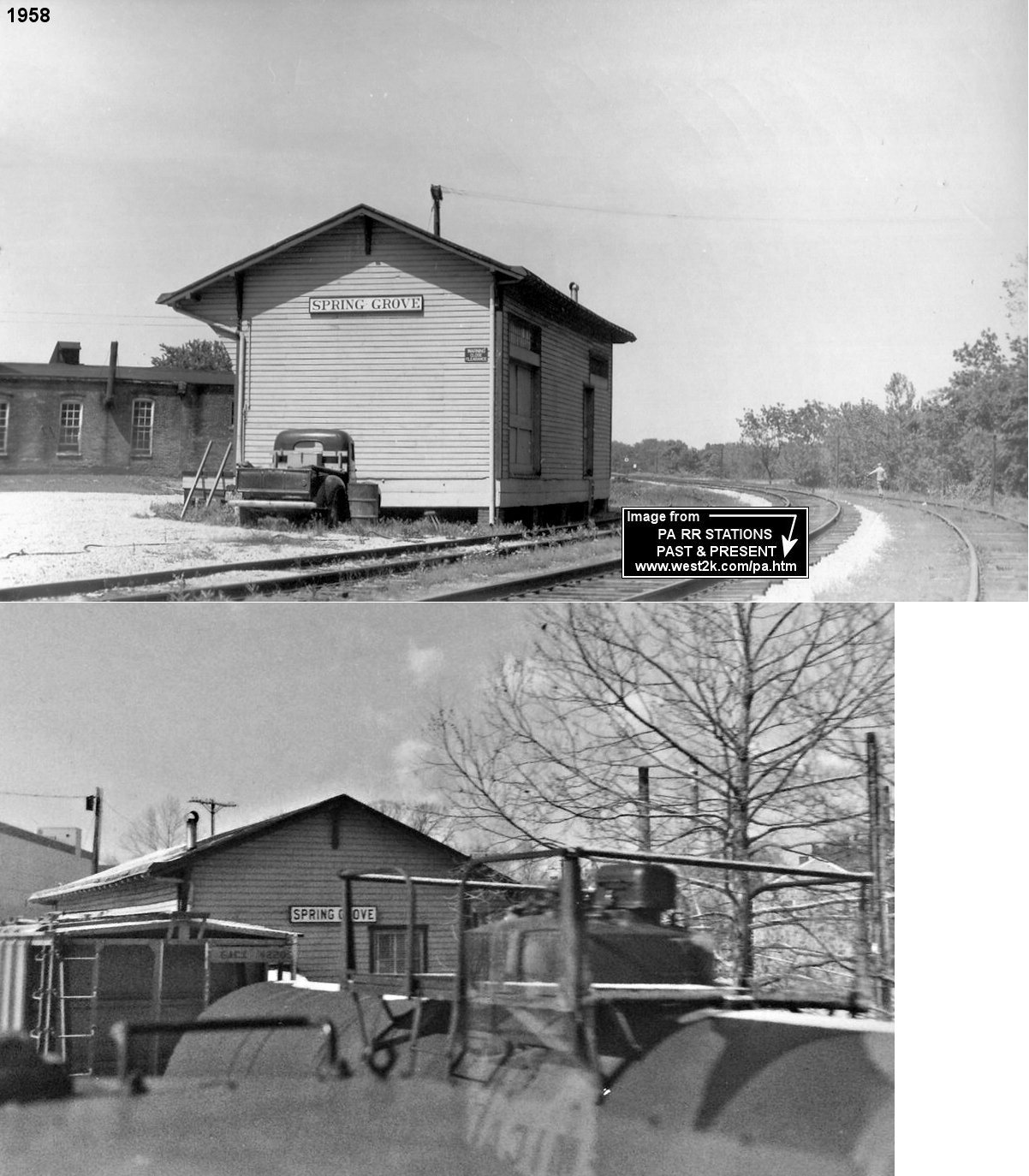
| Spring
Grove (Spring Forge) |
|
Built in 1885. | ||||||
| Spring Grove |
|
Passenger station. | ||||||
| Spring Grove |
|
Freight station. | ||||||
| Springwood |
|
Although there was no station building there, there was a flag stop at Spangler's swimming pool (later known as Springwood Park) at mile post 71.5 between Relay and Ore Valley. | ||||||
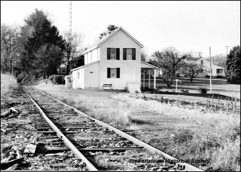
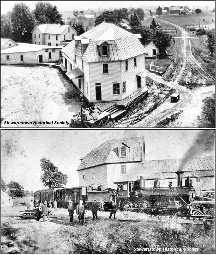
| Stewartstown |
|
This station was built in 1898. It was on the north side of Mill Street at GPS: 39.755137, -76.593755. This is where the New Park & Fawn Grove RR joined the Stewartstown RR. After the new station was built in 1914, this building had various business and private uses before being demolished in the late 1960s/early 1970s. | ||||||
| Stoner Station |
|
This was an early station on the York & Wrightsville RR. It was just east of Hellam where the railroad crossed Ducktown Road. It is shown on the 1876 map and on the 1900 PRR List of Stations & Sidings as well as the 1915 county map. | ||||||
| Stony Brook (Turnpike Sta.) |
|
This station is shown on the 1900 PRR List of Stations & Sidings. It was in the northwest corner of the East Market Street crossing. | ||||||
| Strawbridge |
|
Station was located at Marsteller & New Park Roads in Hopewell Township. Torn down around 2004. There is some debate whether this was actually Strawbridge’s station. Some local experts believe the building was used as a post office and located adjacent to the right of way (which ran behind the building). It finally came down about 2004. What it was used for exactly is not known. | ||||||
| Strickler (Garver) |
|
This station is shown on the 1900 PRR List of Stations & Sidings as well as the 1915 county map. It was between Wrightsville and Stoner. | ||||||
| Summit Station |
|
This was an early station that was the first station east of York. It was on Brillinger Road, which is now called Mt Zion Road (GPS: 39.983208,-76.664894). | ||||||
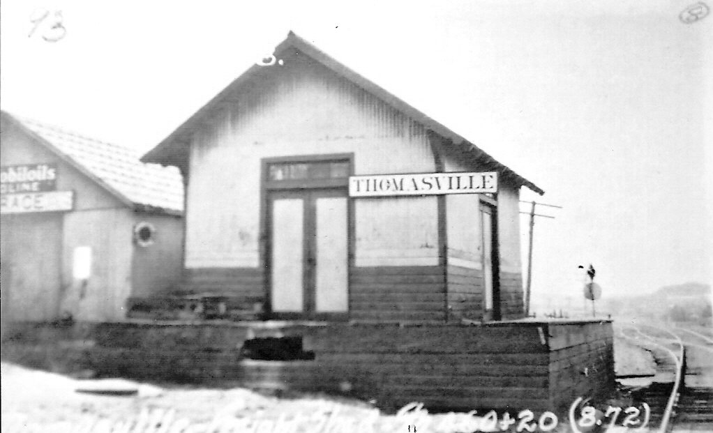
| Thomasville | |
Passenger station. | ||||||
| Thomasville | |
Freight station. | ||||||
| Tolna |
|
The freight station here was across the street from the passenger station and burned down in the late 1970s or early 1980s. | ||||||
| Turnpike Station |
|
This was an early station that was the second station east of York. It was on the Wrightsville Turnpike, which is now East Market Street (PA462) (GPS: 39.986993,-76.644246). Not to be confused with the "Turnpike" station on the Stewartstown RR. | ||||||
| Turnpike (Hungerford) (Shrewsbury) |
|
There was presumably a wooden station here prior to the brick station that was built in 1925. | ||||||
| Valley Junction | |
This was originally the junction of the Bachman Valley RR and the Hanover Branch RR. Both later became part of the Western Maryland Railway. | ||||||
| Wiley Station |
|
This station was on the west side of Draco Road at the intersection with Marstellar Road at GPS: 39.722389, -76.543446. This building was a store and residence, but is not the station. | ||||||
| Wrightsville |
|
The station was loacted on the east side of North Front Street, just south of Hellam Street (GPS: 40.026129,-76.527999). | ||||||
| Yoe |
 |
Station was built in 1898 by York Southern before the MA&PA acquired it. Photo from 1950. The station was closed in 1939 and torn down in 1978. | ||||||
| York |
|
The first railroad-built station here was erected in 1842 by the Baltimore & Susquehanna RR (later Northern Central). Prior to this, the RR used an previously-existing inn as a station. The second station here was built in 1863. The 1887 map shows this brick station on the SE corner of East North Steet and North Duke Street (across the street from the existing passenger station). The original freight house was on the NE corner of the same intersection. | ||||||
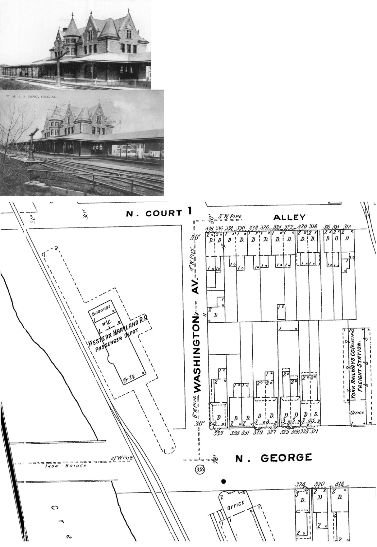
| York | |
This passenger station was on the east side of George Street (at GPS: 39.967695, -76.730101, across from the existing freight station). It opened in September 1896 (The York Daily, 9-2-1896) and was torn down in 1961 (York Gazette & Daily, 6-16-1961). | ||||||
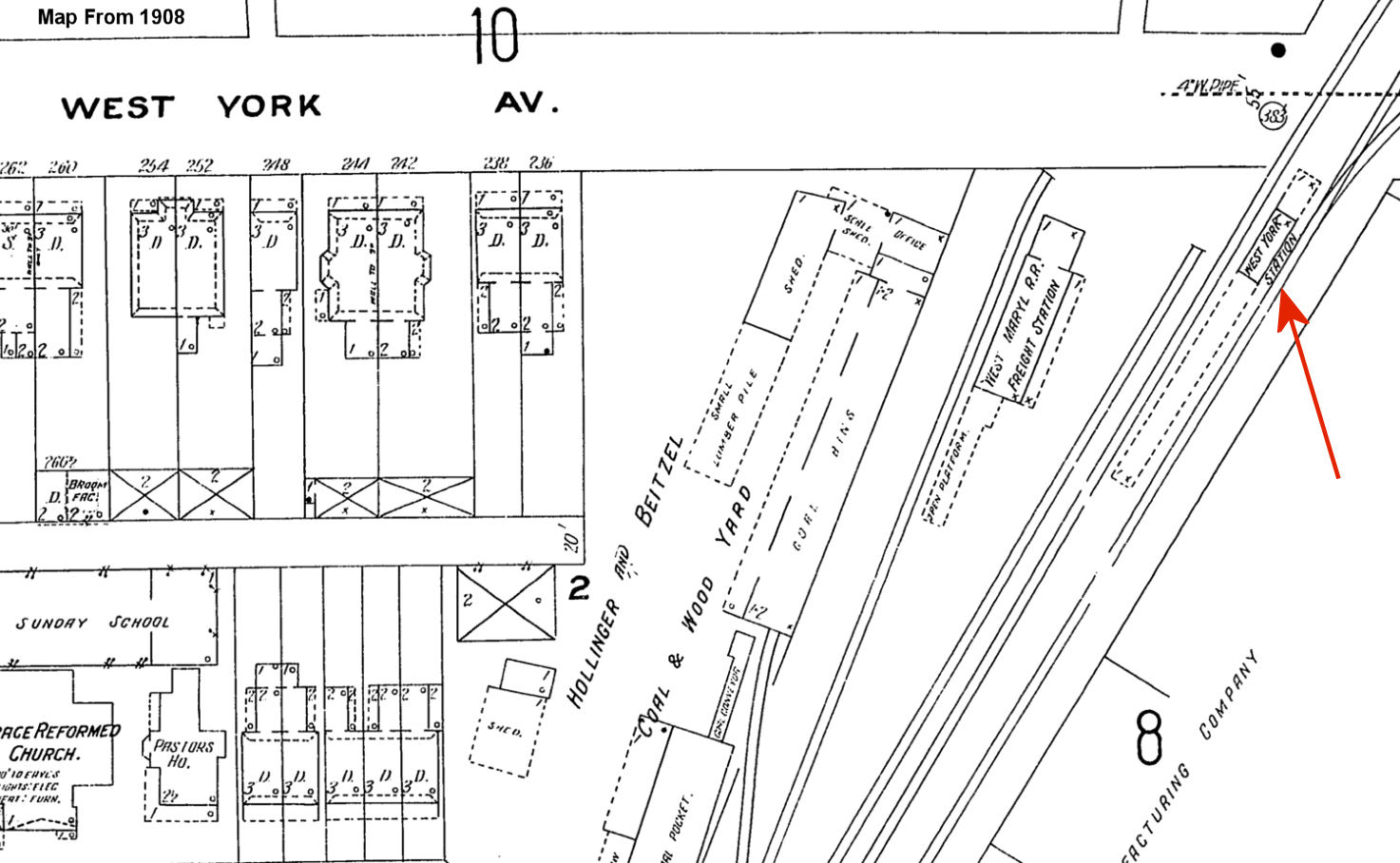
| York (West York) |
|
There was a small passenger station with a long platform on the SW side of Roosevelt Avenue (formerly West York Avenue) at GPS: 39.961885, -76.740348. This was known as the West York PRR Station. | ||||||
| York (West York) |
|
There was a small freight station on the NE side of Roosevelt Avenue (formerly West York Avenue) on the south side of the tracks at GPS: 39.961972, -76.739683. | ||||||
| York | |
The original Peach Bottom RR depot was on the north side of York Street SW of Louck's Mill Road (GPS: 39.968216,-76.724554). This was a brick station that was likely torn down when the MA&PA built a new frame station in 1907 (that station is still standing). | ||||||
| York Haven |
|
This station was built in 1887. | ||||||
| Ziegler |
|
|||||||
| 1895 YORK COUNTY RAILROAD MAP | ||||||||
 |
||||||||
| Notes About Existing
Stations... Brillhart (Northern Central) - This building was a general store, hotel and post office where Northern Central Railway leased a small space for a ticket office and waiting room. A formal passenger station was never built by the railroad. Brogueville (MA&PA) - This building was a general store/station (sometimes post office). The RR never built a dedicated station here. Delta (Peach Bottom RR) - After a converted passenger coach, this was this general store/station was the second station here. Some sources say it was built in 1868, whereas others (the MA&PA RR Historical Society) say 1876. It only served for a short time as a new dedicated station was built in 1888. Glatfelters (PRR) - It is a 2 story orange-ish colored brick building. Milepost 49 is directly across from the building. Also, if you look closely, you can see the foundation for the westbound passenger shelter beside the milepost.. Hallam (Y&W) - A carpenter from Hallam, dismantled and reconstructed the station at the rear of his property near 67?? East Market Street in Hallam in the 1960's. Cherry Avenue (a narrow alley) runs east and west on the north side of Market Street in Hallam. The railroad station originally sat south of Market Street near the old Hallam Furniture Factory. Hanover (PRR/WM) - The station appears as though it was oriented towards the PRR right-of-way, so I suspect that the PRR actually built the station. The station sits between the two right-of-ways, and appears to have served both the WM and PRR. The CSX uses the old WM tracks, and the Ma & Pa uses the old PRR tracks. There is a diamond and an interchange just east of the station. --Greg Halpin Hanover Junction (Northern Central) - York Co. rail/Trail Authority to start restoration of this station in the near future. It will be restored to it's 1863 time frame. Formerly a hotel, tt was used by the PRR, NCR, the Hanover Jct. Railway, and Western Maryland. Laurel (MA&PA) - Laurel - The MA&PA station in Laurel was located in a general store. The building is currently used by a woodworking business. The tracks are still in place, extending about 500 feet north, and owned by an Authority of York County. Eventually, the Maryland and Pennsylvania Railroad Preservation Society hopes to extend the rail excursions operated from Muddy Creek Forks as far north as Laurel Muddy Creek Forks (MA&PA) - This station was located in a large general store built in 1900 by A.M. Grove. The station is located along a six mile section of the original M&P mainline acquired in 1986 by the Maryland and Pennsylvania Railroad Preservation Society. The store/station and surrounding village was acquired by the Society in 1996. The buildings and tracks are now owned by an Authority of York County. The Society has restored the store, including the station room, to its 1920s appearance. The village is open on Sundays during the summer and excursions are offered by the Society from the station over 3 miles of the track. New Freedom (Northern Central) - Bill Knepper of the York Co. Rail/Trail Authority writes, during restoration, we discovered the station was enlarged three times, we could tell that because the wood was of three different sizes. It looks like the original section was the passenger end, later it looks like the freight shed was built on, and later the freight end was enlarged. About 15 feet was added to the north end. The station was disassembled and rebuilt in 1999. Now home to the New Freedom Rail Trail Cafe Red Lion (MA&PA) - The building is owned by the Red Lion Area Historical Society and is in the process of being restored as a museum as of 2015. Recently the society returned the tracks to the south side of the building. The borough removed the tracks some 10 years ago for a storm drain project and did not return them, so the Historical Society took on the project in 2014 and finished it in 2015. Seven Valleys (Northern Central) - This is the second oldest existing station in continuous use in the USA. It is now a general store. The only unscheduled closing was for four hours during the assassination of President McKinley in 1903. The waiting room still has the arrival and departures boards hanging on the wall from the 1950's, and the station masters office remains in use as the manager's office. The ticket window remains as originally constructed in 1838. Snyderstown (Yoe) (MA&PA) - Combination general store/post office/passenger station. Village was originally called Snyderstown, but the Postal Service rejected the name for a post office as another already existed in Pennsylvania. Town was then renamed Yoe. A second Yoe passenger/freight station was built later, across the street, and was razed by the railroad in the 1970s. Strickhousers (Northern Central) - This building was an ore-loading freight station. The railroad was constructed along the West Branch of the Codorus Creek that forms the right of way lane to the next farmhouse. Iron ore was discovered on the hills on the north side of Green Valley Road. A railroad spur was constructed along the hills down to this station. The iron ore was floated in rail cars (by gravity) to Hanover Junction. Stewartstown (Stewartstown RR) - This station opened on Dec. 29, 1914. It as the original waiting room, ticket office, and freight house. It's a brick station, however second story is wood. The Railroad has been closed to tourists for a few years now since a derailment a couple years back on their Easter Bunny Train. The station is currently in poor condition with holes in the roof and a crumbling platform. Volunteers occasionally will maintain the tracks to a certain degree, but for the most part, past Tolna the railroad is abandoned with exempt signs at the grade crossings. --Thomas Gallion, 2007 Tolna (Stewartstown RR) - Building served as a station, post office and general store. York (Northern Central) - This station is labeled as the "Grand Union Passenger Station" on the 1893 Sanborn Insurance map. For more information and photos on all York city and county stations see Greg Halpin's page Railroads and Railfanning In and Around York! The NCR relocated the main line through York in 1890 thus neccessitating a new passenger and freight station that year. York (WM Freight) - Only the brick head end of this station remains; the wood frame section has been torn down. York (PRR Freight) - There are two buildings in this freight complex, one on each side of North Street. York (MA&PA) - Now serves as the housing authority maintenance department. For more information and photos on all York city and county stations see Greg Halpin's page: Railroads and Railfanning In and Around York! |
||||||||