|
|
||||||||
| EXISTING STATIONS | ||||||||
|---|---|---|---|---|---|---|---|---|
| Station Name |
Original Railroad |
Current Location |
Type | Current Use |
Date Built |
Track Status |
Building Material |
More Info |
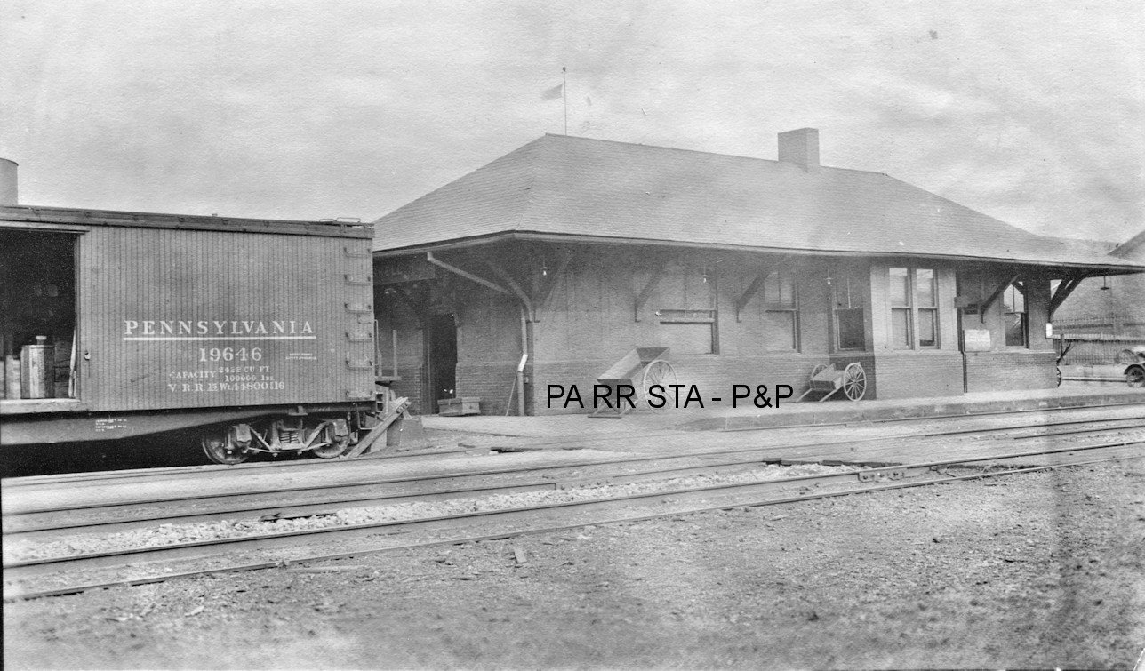
| Bethel |
 |
2369 PA 318 (GPS: 41.190819, -80.392121) |
P | Residence | ???? | Gone | Wood |
|
| Farrell |
 |
920 Broadway Avenue (GPS: 41.215304, -80.507282) |
F | Business | ???? | Gone | Brick | |
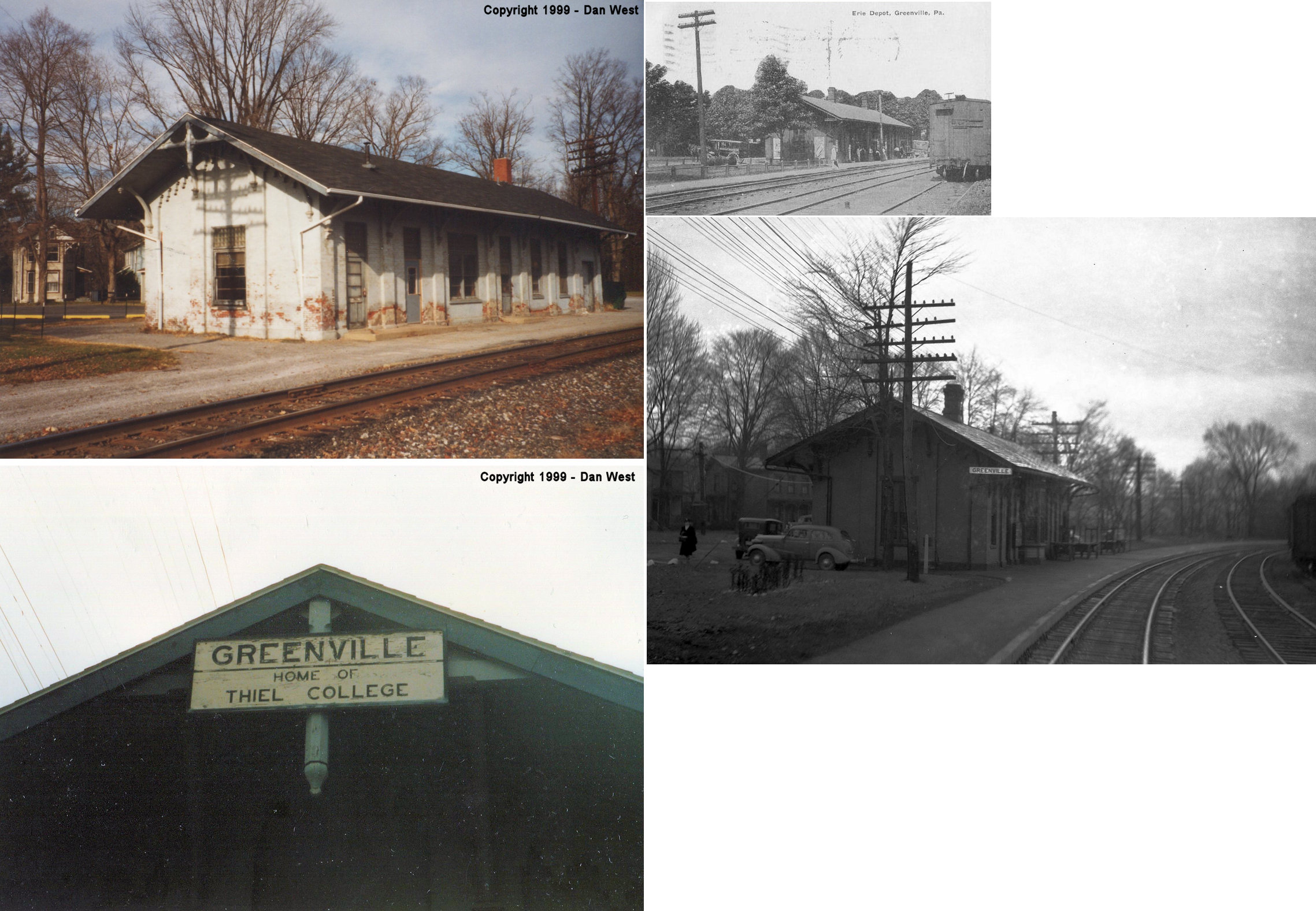
| Greenville |
 AND  |
Main Street & Grant Street (GPS: 41.407920, -80.381843) |
C | Railroad | 1872 | In Use | Brick |
|
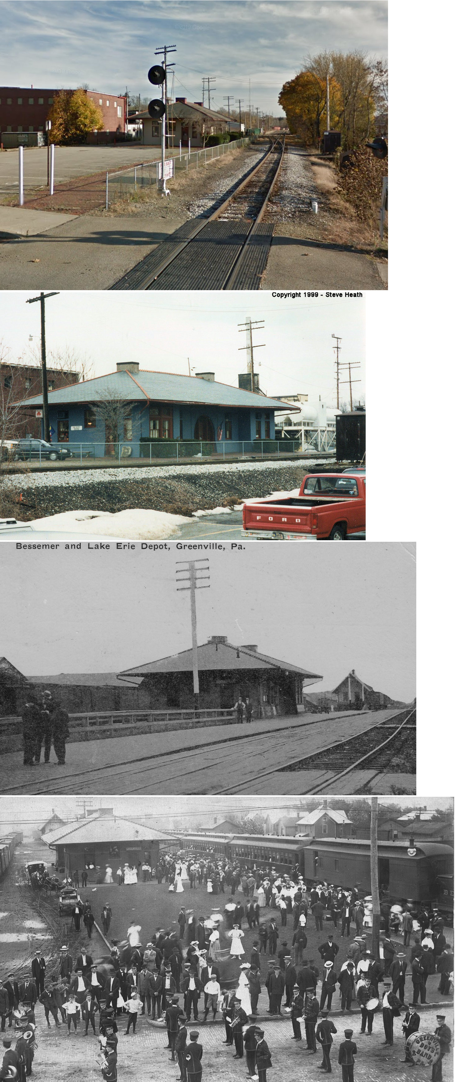
| Greenville |
|
Clinton & South Race Streets (GPS: 41.403615, -80.388831) |
C | Business | 1901 | In Use | Brick |
|
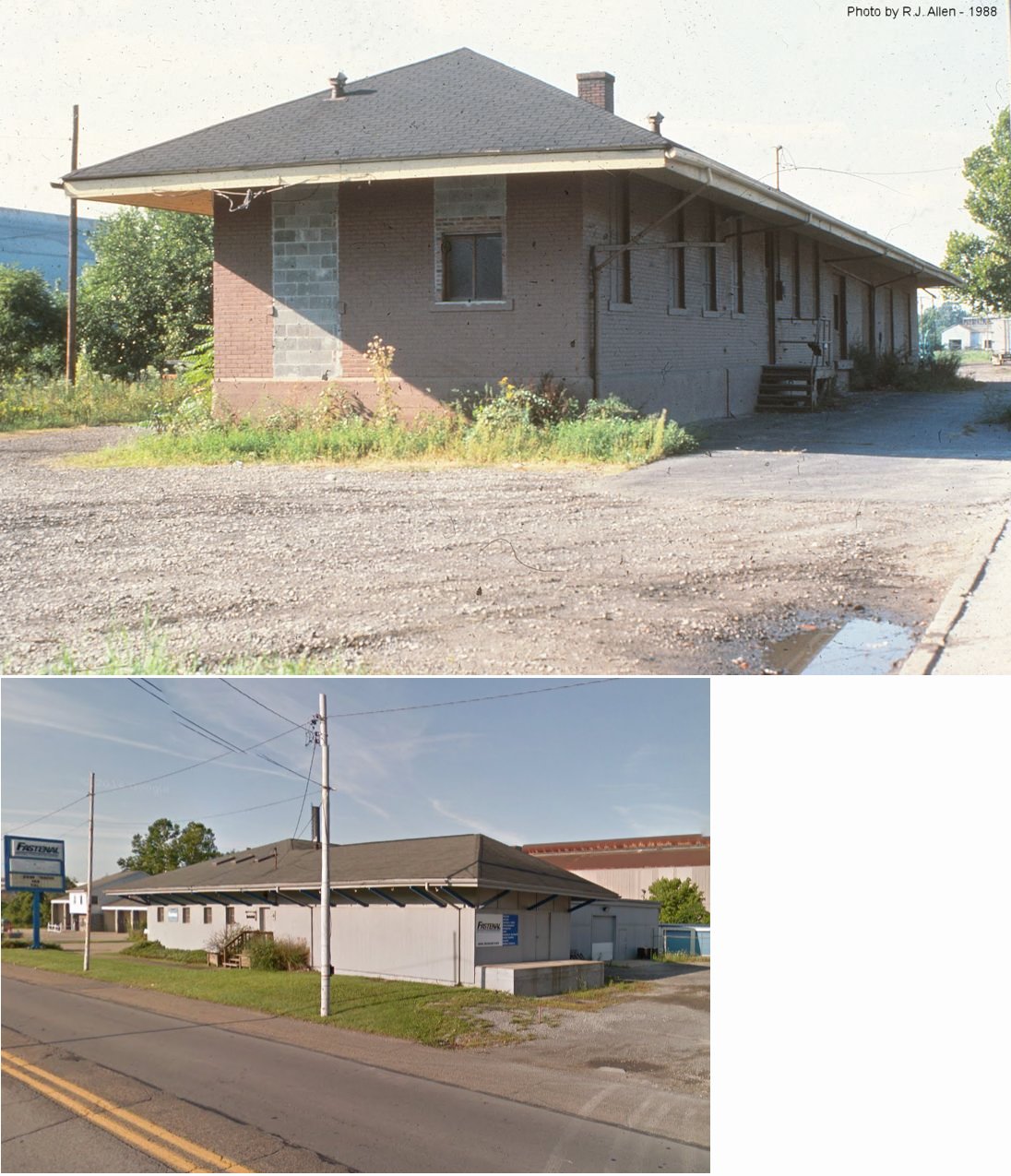
| Grove City |
|
West end of Erie Street (GPS: 41.162283, -80.091747) |
F | Business | 1898 | In Use | Wood | |
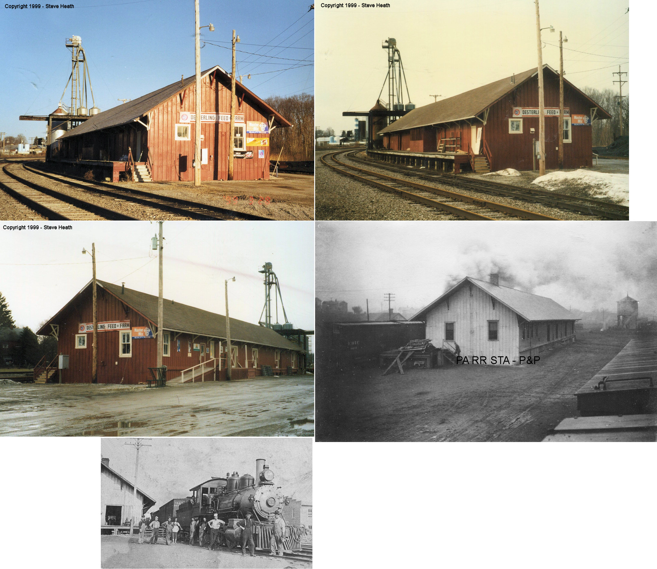
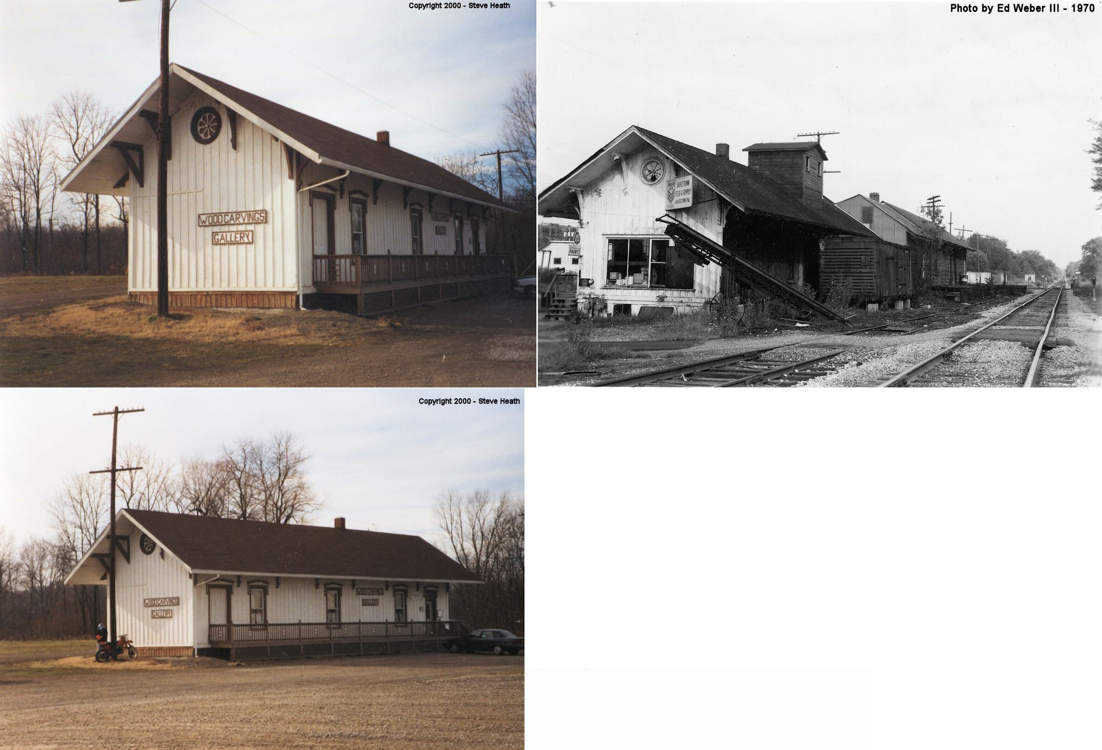
| Jamestown |
 |
South end of Main Street (GPS: 41.483243, -80.438853) |
C | Business | 1872 | Gone | Wood |
|
|
Oakland (New Virginia) |
|
1220 Keel Ridge Road (GPS: 41.217240, -80.419667) |
P | Residence | 1927 | Gone | Brick |
|
| Sharon |
|
Northeast corner of Main and State Streets (GPS: 41.233070, -80.512215) |
P | ???? | ???? | ???? | Brick |
|
| Sharon |
 |
101 Chestnut Avenue (GPS: 41.230606, -80.507168) |
F | Restaurant | ???? | In Use | Wood | |
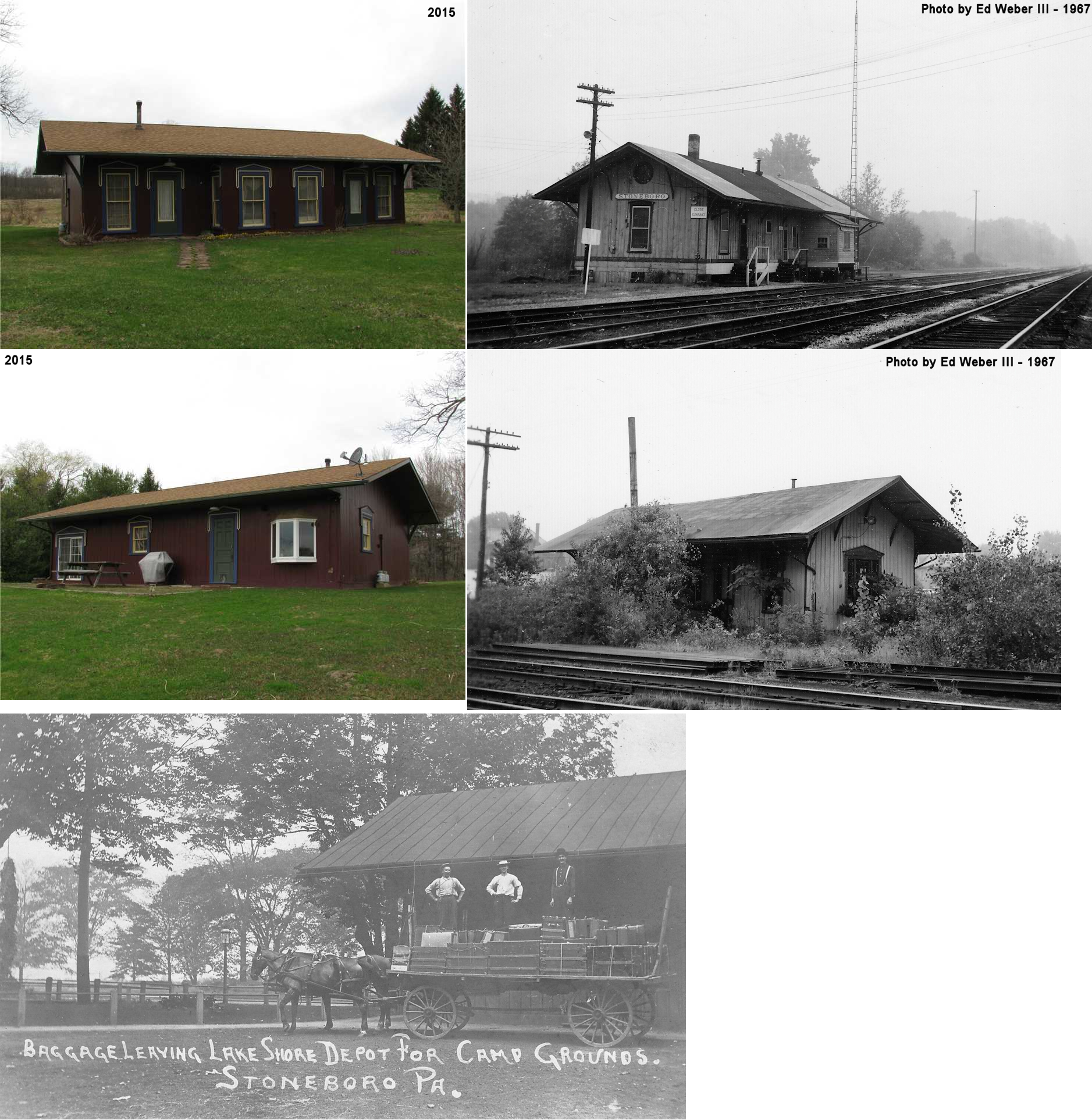
| Stoneboro |
|
517 Carpenters Corners Road (CR1101) near Clarks Mills (GPS: 41.416734, -80.193130) |
P | Private | 1866 | None | Wood |
|
| STATIONS OF THE PAST | ||||||||
| Station Name |
Original Railroad |
Notes | ||||||
| Amasa |
|
In 1875 the name of this crossing was changed from A&GW Crossing to Amasa (named after Amasa Stone). The station is listed here on the 1880 LS&MS timetable. In 1883 a larger depot was built here. According to the Greenville Record Argus of 2-15-1883, "The 'seven by nine' depot at Amasa will soon be vacated for the occupancy of a new one almost completed. The new one, though not large, is of more comfortable proportions than the old one." Earlier, in 1881, the newspaper reported that the LS&MS and NYP&O were going to build a union depot there. It is not clear if the 1883 depot was that union depot or just a new LS&MS depot. In 1888, the superintendent of the LS&MS announced that "the station of Amasa, on the Franklin Division, has been changed to Osgood; also that Amasa station at the Nypano crossing will continue a Lake Shore ticket station" (Greenville Record Argus, 9-22-1888). Passenger service ended there sometime near the turn of the century, but resumed in 1912 (Greenville Record Argus, 3-22-1912). | ||||||
| AMASA |
|
|||||||
| Branch |
|
|||||||
| Camp Reynolds |
 |
See listing for "Victory" below. | ||||||
| Carlton (Evans' Bridge) |
|
A station is shown here on the 1873 map on what is now O'Brien Lane at approximately GPS: 41.471547, -80.016312. The 1881 book, "Report of the condition of the Atlantic and Great Western railroad it's branches and leased lines: and an inventory of the property and effects of every description," lists a "162?32 wood shed with 17 feet enclosed and used as depot, needs painting, stone foundation, good." The Erie valuation records from 1919 list a build date of 1881. | ||||||
| Carmona |
 |
This station was on the PRR's Wolf Creek Branch at MP 9.1 (distance from Leesburg station). | ||||||
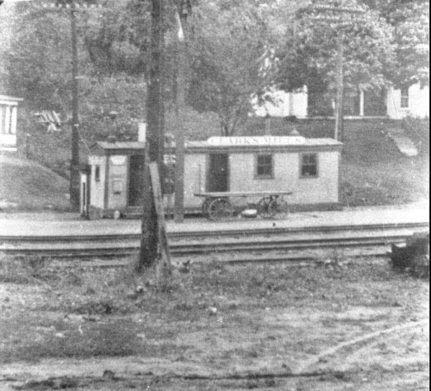
| Clarks Mills |
|
This station was on the south side of Greenville-Sandy Lake Road on the north side of the tracks at GPS: 41.393080, -80.183295. As of 1919 the station here was a 8'x28' old car body. There was also a 8'x22' car body that served as a freight station. | ||||||
| Clarksville Station (Clark) (Clarksboro) |
|
The road this station was on was submerged when the Shenango River Resevoir was filled. It was in the general vicinity of GPS: 41.290237, -80.441566. This station is shown on the 1873 map, however a newspaper article from December 1880 remarked that the E&P planned to build a depot there and it was the last one to be completed on the line (Conneautville Courier, 12-9-1880). The town was moved in the early 1960s to allow for a dam and flood control measures. When the town was moved the name was shortened to "Clark." On the 1923 PRR List of Stations & Sidings, the station is called "Clarksboro." | ||||||
| Cool Spring |
|
This early Shenango & Allegheny RR station, as shown on the 1873 map, was on the northern edge of Cool Spring Township just south of where US 19 crosses the tracks south of Fredonia. The station was at approximately GPS: 41.300634, -80.239914. | ||||||
| Coulson |
|
This station was at mile post 33.1 (distance from Mahoningtown) on the New Castle Branch. | ||||||
| Courtneys Mills |
|
This station was on the PRR's Wolf Creek Branch at MP 10.7 (distance from Leesburg station). | ||||||
| Drake |
|
This station was on the PRR's Wolf Creek Branch at MP 4.1 (distance from Leesburg station). | ||||||
| Farrell (South Sharon) |
|
This station was on the north side of the west end of Roemer Street (formerly Haywood Street) at GPS: 41.212225, -80.507208. It was built in 1901. | ||||||
| Farrell (South Sharon) |
|
There was a combination station on the west side of Broadway Avenue just north of Roemer Street (formerly Haywood Street) at GPS: 41.212429, -80.506266. It was built sometime between 1903-1908. | ||||||
| Farrell |
|
There was an earlier freight station here that was built in 1889 according to Erie valuation records. | ||||||
| Farrell |
|
There was a 30'x116' station here that was built in 1887 according to NYC valuation records from 1919. This was on the Sharon Branch. | ||||||
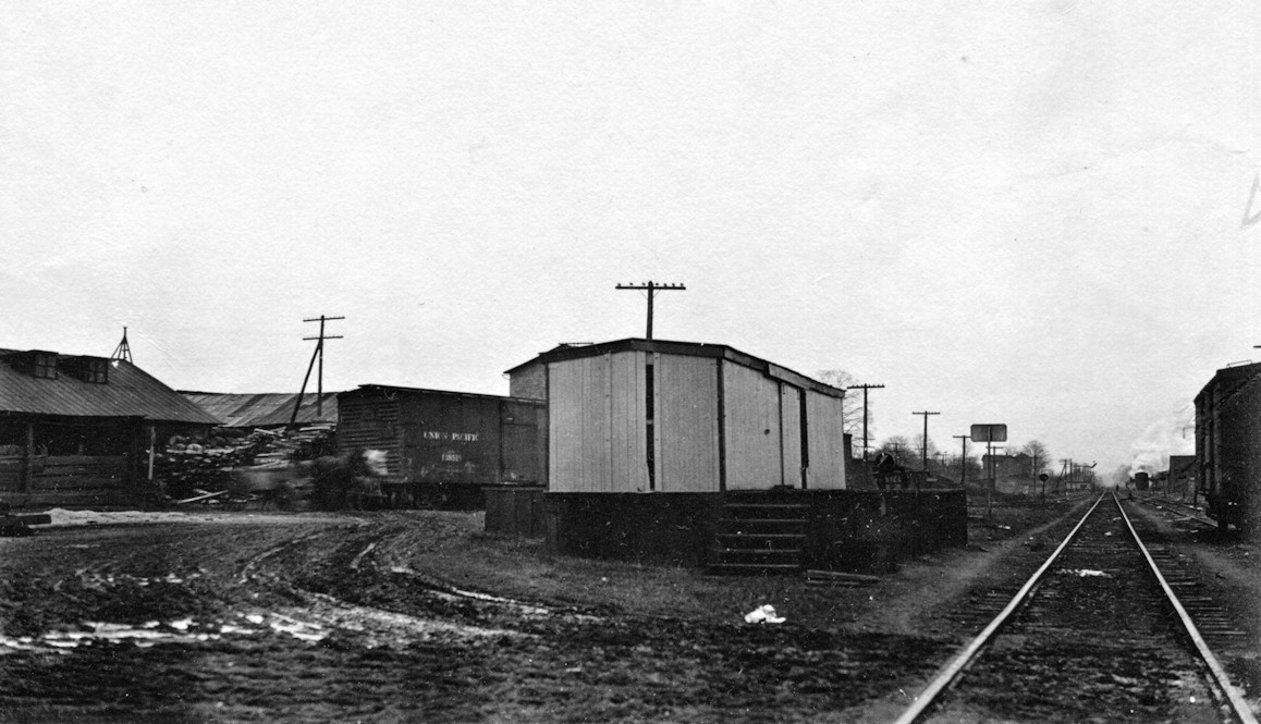
| Ferrona |
|
There was a freight station in the Ferrona yard that was built in 1885 according to the Erie valuation records from 1919. | ||||||
| Filer |
|
|||||||
| Fredonia |
|
In 1873 the station was north of 3rd Street on the south side of the tracks between Main Street and Water Street at GPS: 41.323055, -80.258722. | ||||||
| Greenville |
|
This station was on South Front Street just south of Virginia Way at GPS: 41.402593, -80.392539. This station was built in 1873 replacing a previous depot that was described by the newspaper as a "shanty" (Greenville Argus, 8-16-1873). PRR valuation records list the build date as 1875. | ||||||
| Greenville |
|
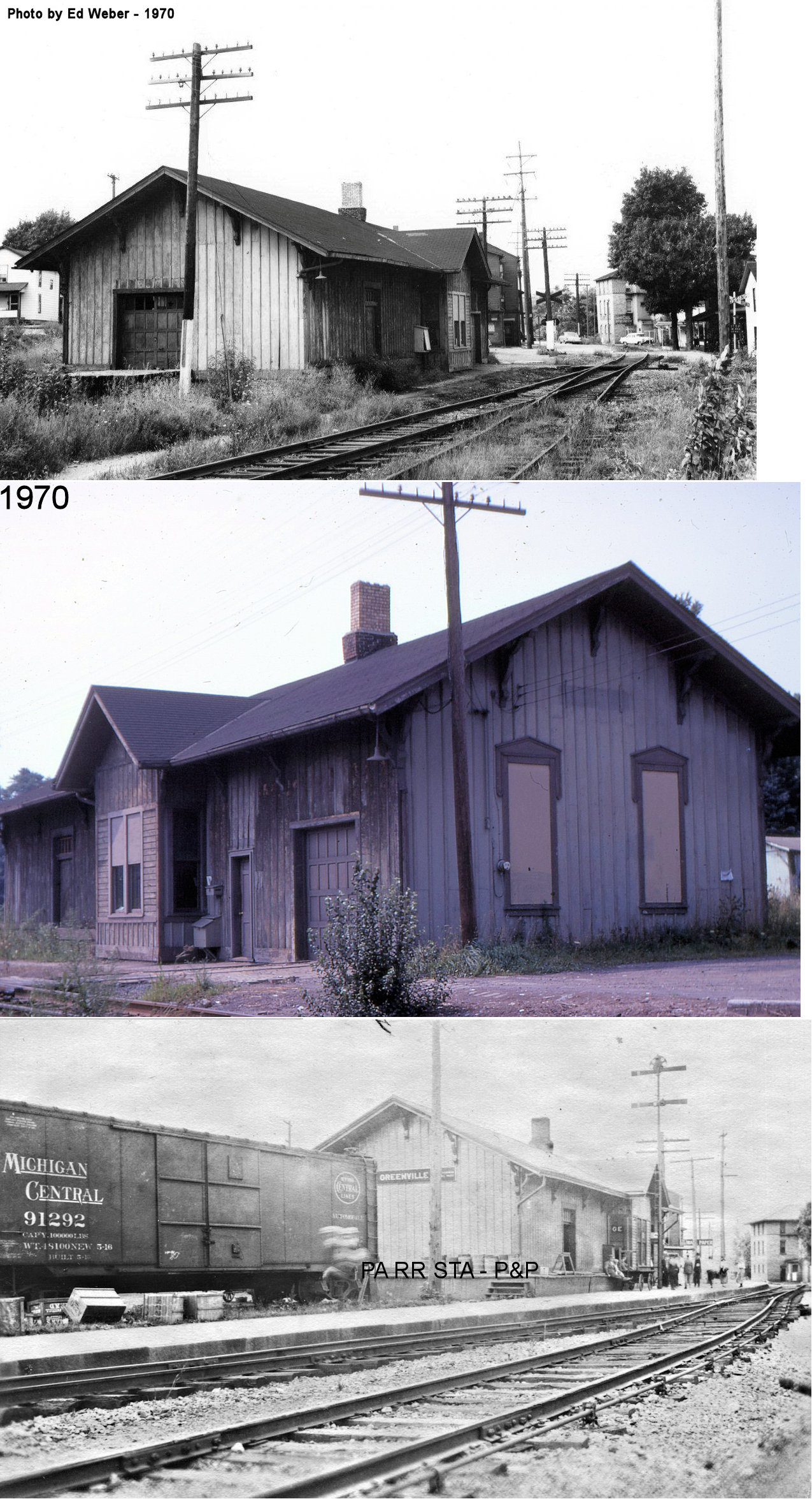
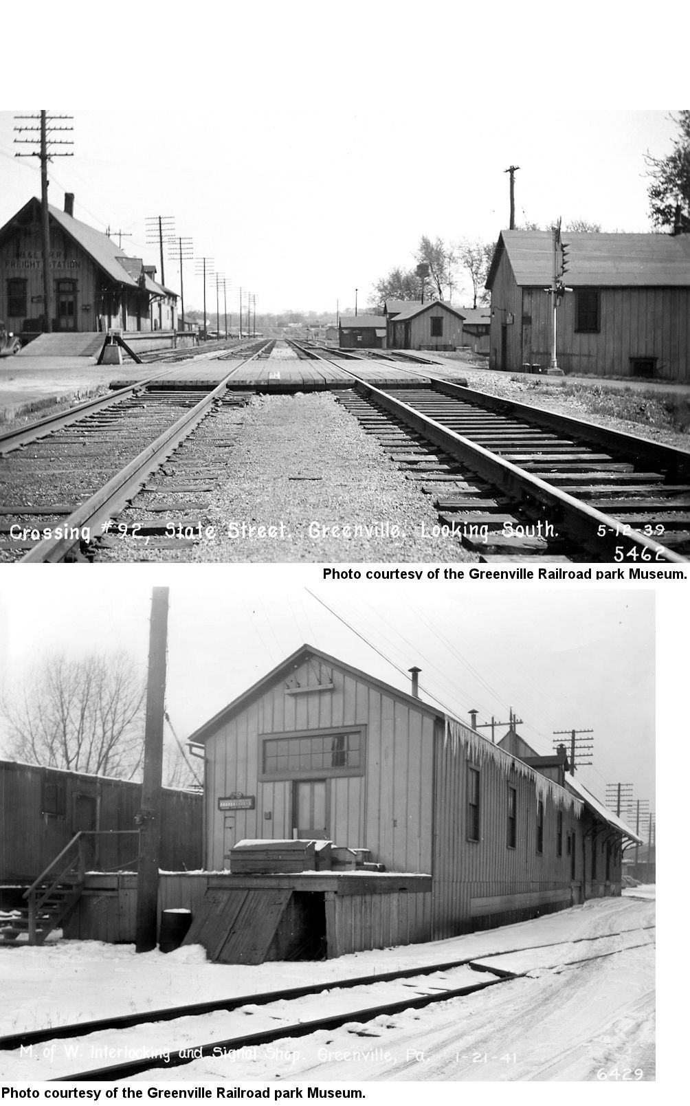
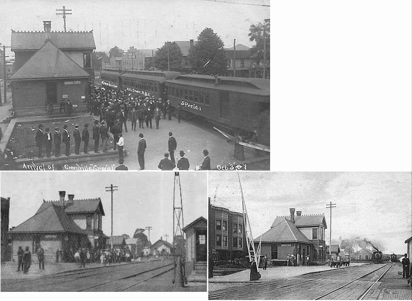
The earliest Greenville station on this line was a wood frame station of of typical Shenango & Alleheny design with a high roof line that was on the south side of Clinton Street. This station and the one listed below appear to have both been in service at the same time, although in 1896 this wooden station was moved (Greenville Record Argus, 11-12-1896) slightly south about 300 feet. When the new brick station on Clinton Street was built, it was moved south again a short distance (still along the east side of the tracks) to GPS: 41.402742, -80.388161 just above State Street. The photos show the old station in its final location being used as a freight staion. It was torn down in the mid-1970s. For the details on the evolution of the B&LE stations via Sanborn Insurance maps, see this page. | ||||||
| Greenville |
|
In the early years of the Pittsburgh, Shenango & Lake Erie (B&LE
predecessor), there were two stations in Greenville about two blocks from
each other. One was a two story brick building on the north side
of Main Street on the west side of the tracks at GPS:
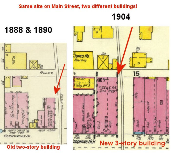
41.404908, -80.389929. Here's why there were two stations on the same line so near each other: There were briefly two different railroad companies in charge of the line through Greenville when it was connected northward. From the south, the Shenango & Allegheny ended at the old wooden station on Clinton Street. From the north was the Erie, Shenango & Pittsburgh Railway Company which formed in 1887 and bought the old canal tow path from Greenville northward. The two lines were not connected at first. The S&A ended at the Clinton Street S&A depot and the ES&P ended at Main Street so there was a gap between them. The ES&P line wasn’t complete then so it’s not like it was running it’s own trains at the time. But, this might explain the station on Main Street as being the original property of the ES&P before the merger, so perhaps the plan was to have a station there when they were two different companies. Here’s what the book “The Bessemer & Lake Erie Railroad” by Roy C. Beaver (1969) says about the two lines finally connecting: “The company [ES&P] commenced construction of three and a half miles of line from Greenville to Osgood in in 1887 which would provide a connection at the latter point with the LS&MS’s Oil City Branch. The S&A, which terminated at Greenville, undertook to make a two-block-long connection with the new line in Greenville by extending a track from its passenger station on Clinton Street. It is reported that under cover of darkness workmen threw a track across Main Street, which was then unpaved, knocked out the front and back walls of a building, erected cribbing in the cellar to support their track and for a time ran construction trains through the building." The ES&P was consolidated with the PS&LE on June 8, 1888 and trains began running to Osgood on Dec. 17, 1888. When the railroad built the new station (still standing) in 1901, this two-story brick building on Main Street was demolished and replaced with a three-story building that then housed B&LE offices. That office building still stands at that location (as of 2020) as the "Old Town Building" at 160 Main Street. |
||||||
| Greenville |
|
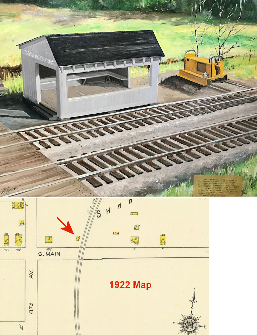
Before an underpass was built at the tracks on South Main Street (PA-358), there was an open-sided passenger shelter on the north side of the street on the west side of the tracks at GPS: 41.410748, -80.368750. A painting of it hangs in the Greenville Railroad Museum Park building and the caption reads, "This painting is of a model of the Bessemer & Lake Erie waiting depot on South Main Street, Greenville, Pennsylvania. The building was demolished in 1929. The model was built by Delmar M. Keeley. As a small boy he played in and around the depot. He lived adjacent to the depot." A small building is shown at this location oriented toward the tracks on the 1922 Sanborn map (the first year this section of town appeared on the map), but the building is not labeled. | ||||||
| Greenville |
|
The original station here was burned by arsonists in late May 1871 after it was revealed that an immigrant family with smallpox had stopped here to transfer to the the E&P station on the other side of town. Although the family did not appear sick until the next day at the E&P station, unknown parties burned the A&GW station. The newspaper reported that no effort was made to extinguish the fire as most in town were glad to see it go given its shabby appearance (Greenville Advance, 6-3-1871). A temporary station (a "rough board shanty") was quickly built by the end of June 1871 (Greenville Advance, 6-28-1871) | ||||||
| Greenville |
|
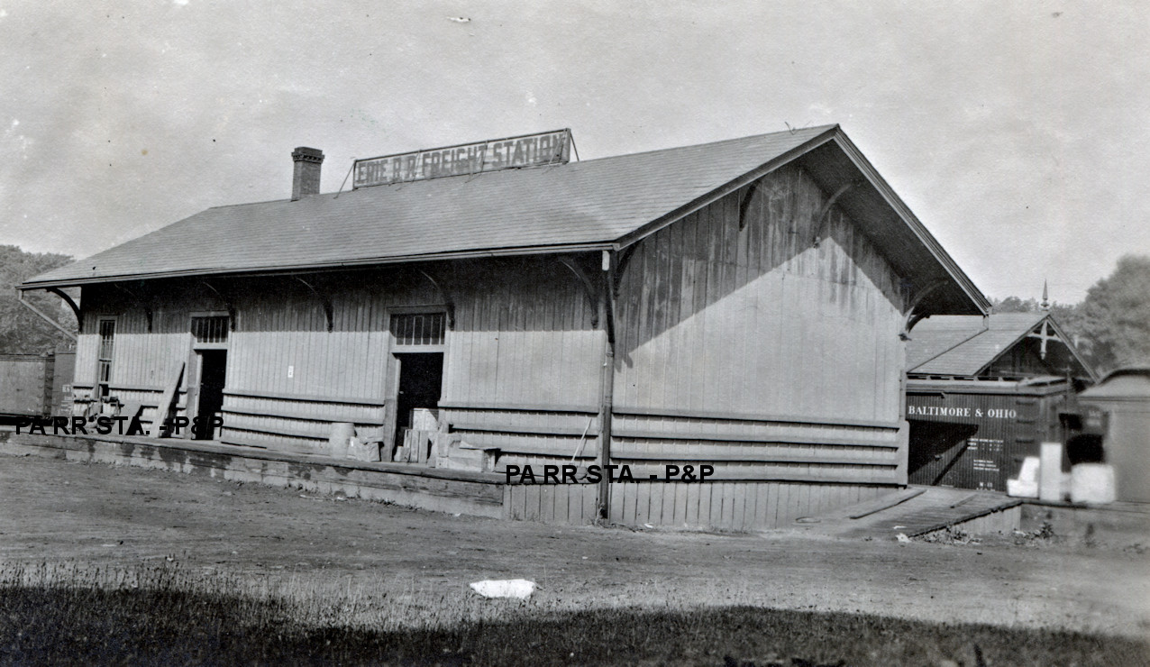
There was a freight station across the tracks from the passenger station on the north side of Main Street at GPS: 41.407841, -80.381455. It was built at the same time as the passenger station in 1872. It fell into disrepair after being vacated in 1976, and was demolished by Conrail on June 29, 1981. | ||||||
| Grove City |
|
This station was on the corner of Blair Street and South Broad Street at GPS: 41.161385, -80.086400. It was the second depot here. The original station burned down in May, 1890 in a fire that claimed 14 businesses, a residence and the depot. | ||||||
| Grove City (Pine Grove) |
|
A station is shown here on the 1873 map when the town was known as Pine Grove and the railroad was the Shenango & Allegheny. The original freight house was on Blair Street just west of South Center Street at GPS: 41.161551, -80.087802. This station burned down on August 20, 1897 in a fire that also claimed the nearby McKay Carriage Works (New Castle News, 8-24-1897). The new freight station (still standing), was built in 1898. | ||||||
| Grove City |
|
There was a freight transfer shed in the B&LE yard here. | ||||||
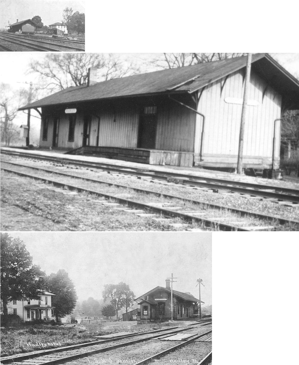
| Hadley |
|
The station was onthe south side of Fredonia Road at approximately GPS: 41.413704, -80.231056. In a Dec. 19, 1981 story in the Greenville Record Argus about former station agent Lynn Rodgers, it was claimed that the station was built in 1867, however NYC valuation notes from 1919 claim that the station was built in 1874. Those valuation notes give the station measurements as 20'x83'. The station was closed in December 1956 and sold to a private party. It was eventually torn down. | ||||||
| Heath |
|
This station was on the PRR's Wolf Creek Branch at MP 11.7 (distance from Leesburg station) in the vicinity of GPS: 41.099414, -80.070704. | ||||||
| Henlein Station |
|
This station was on Leech Road at approximately GPS: 41.415031, -80.368147. | ||||||
| Hope Mills |
|
This station was on Old Mercer Road at approximately GPS: 41.189149, -80.231965. A station is shown here on the 1923 PRR List of Stations & Sidings. | ||||||
| Houston Junction |
AND |
This station was on Houston Junction Road at approximately GPS: 41.231734, -80.212500. There was a station here as early as 1869. The station closed in 1919 (New Castle News, 3-3-1919). It was also known as the New Castle & Franklin Crossing. | ||||||
| Jackson Center |
|
The station entered "non-agency" class in 1931 (New Castle News, 9-29-1931). Charles Frederick Zittel was the station agent here from 1890 until the early 1900s. The 4-mile Jackson Branch was 1.5 miles from the station running to the SE. That branch served five collieries. | ||||||
| Jamestown |
|
This appears to be an older freight station. I'm not sure this is even Jamestown, PA. Can someone confirm/deny? | ||||||
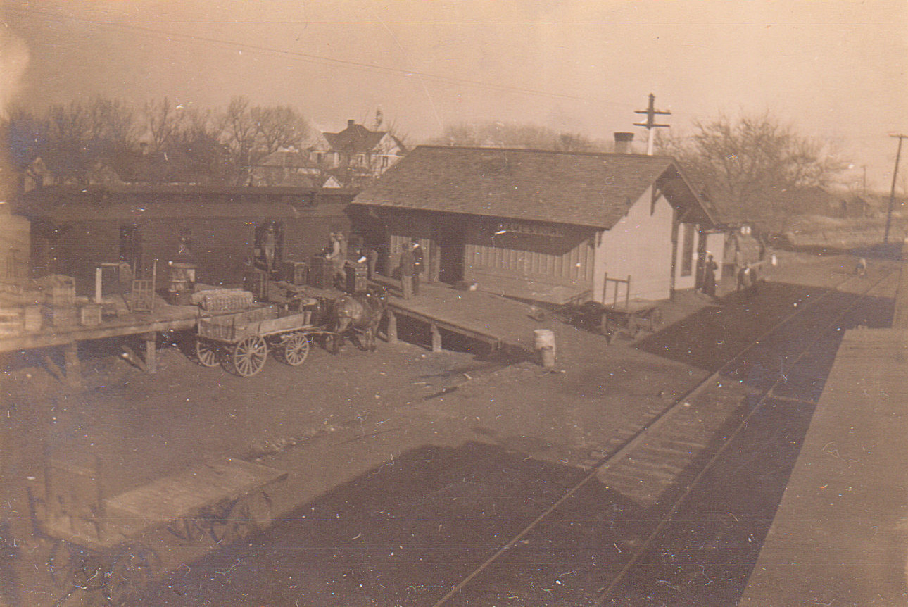
| Jamestown |
|
This freight station was was built in 1904. | ||||||
| Jamestown |
|
This additional freight house, which was an old boxcar body, was placed in 1905. | ||||||
| Jamestown |
|
The first station here burned down during the first week of April 1888 (Greenville Advance Argus, 4-12-1888). It had previously been remodeled by the railroad in 1876 (Conneautville Courier, 6-14-1876). | ||||||
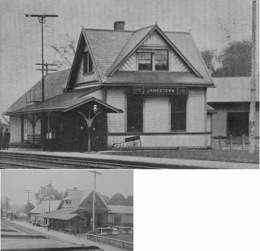
| Jamestown |
|
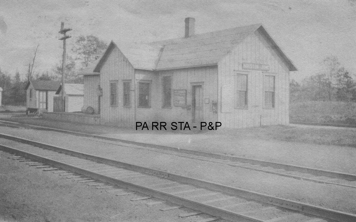
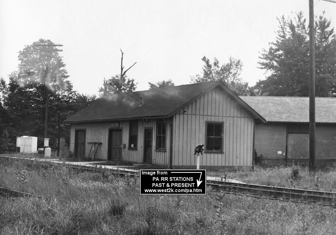
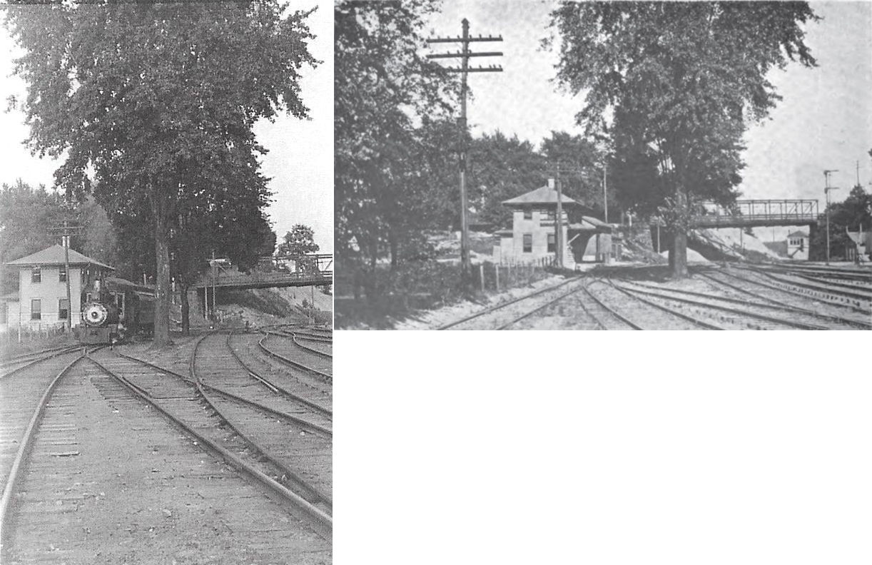
This station was built in 1888 following the loss of the previous depot to fire. Picture of station is from a post card of about 1905. The station was heavily damaged in 1920s by collision of a NYC and PRR train at the crossing. Station was rebuilt (see listing below) as a single story affair. Station was torn down about 1961 after agency closed in 1959 or 1960. In the background on the right is the east end of LS&MS (NYC) freight station. PRR also had a smaller freight shed/platform and house track on east side of the E&P at one time. This station was located between Depot Street and Main Street at GPS: 41.483414, -80.438383. | ||||||
| Jamestown |
|
This was the rebuilt station after the collision in the 1920s. It may have been a new rebuild or modification of the remaining freight end of the original station. | ||||||
| Keelridge |
|
This station was on Morefield Road. It is hard to tell where the grade crossed this road now, but a best guess is around GPS: 41.225953, -80.436855. The station is shown on the 1873 map when the railroad was known as the Keelridge, Sharpsville & Oakland RR. | ||||||
| Kennard |
|
See listing for Sugar Grove below. | ||||||
| Kremis |
|
This station was known as "Hanburg" until 1884. | ||||||
| Leech's Corner |
|
The Shenango Valley Argus reported in its April 22, 1876 edition that the LS&MS had plans to construct a station here in the summer of 1876. It is not known if that came to fruition. | ||||||
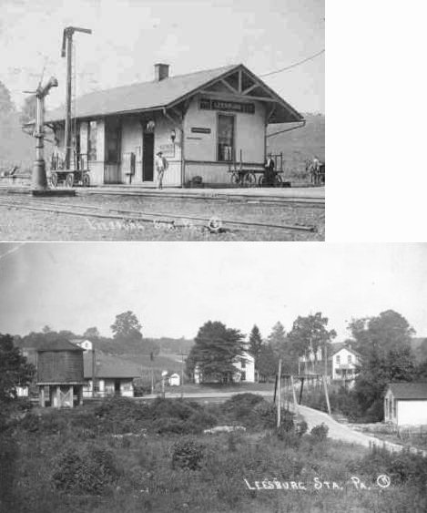
| Leesburg Station |
|
This station was on Leesburg Station Road at approximately GPS: 41.143133, -80.240532. This station was at mile post 16.8 (from Mahoningtown Station) and the junction of the Wolf Creek Branch was nearby (at MP 16.9). | ||||||
| Leesburg Station |
|
Perhaps this station predated to one pictured above? A new station was built here in 1886 when the line was still known as the Buffalo, New York & Philadelphia RR (Daily City News, 3-9-1886). | ||||||
| Lyons |
|
There was a station here as well as "SY" cabin. It was at mile post 33.1 (distance from Mahoningtown) on the New Castle Branch. | ||||||
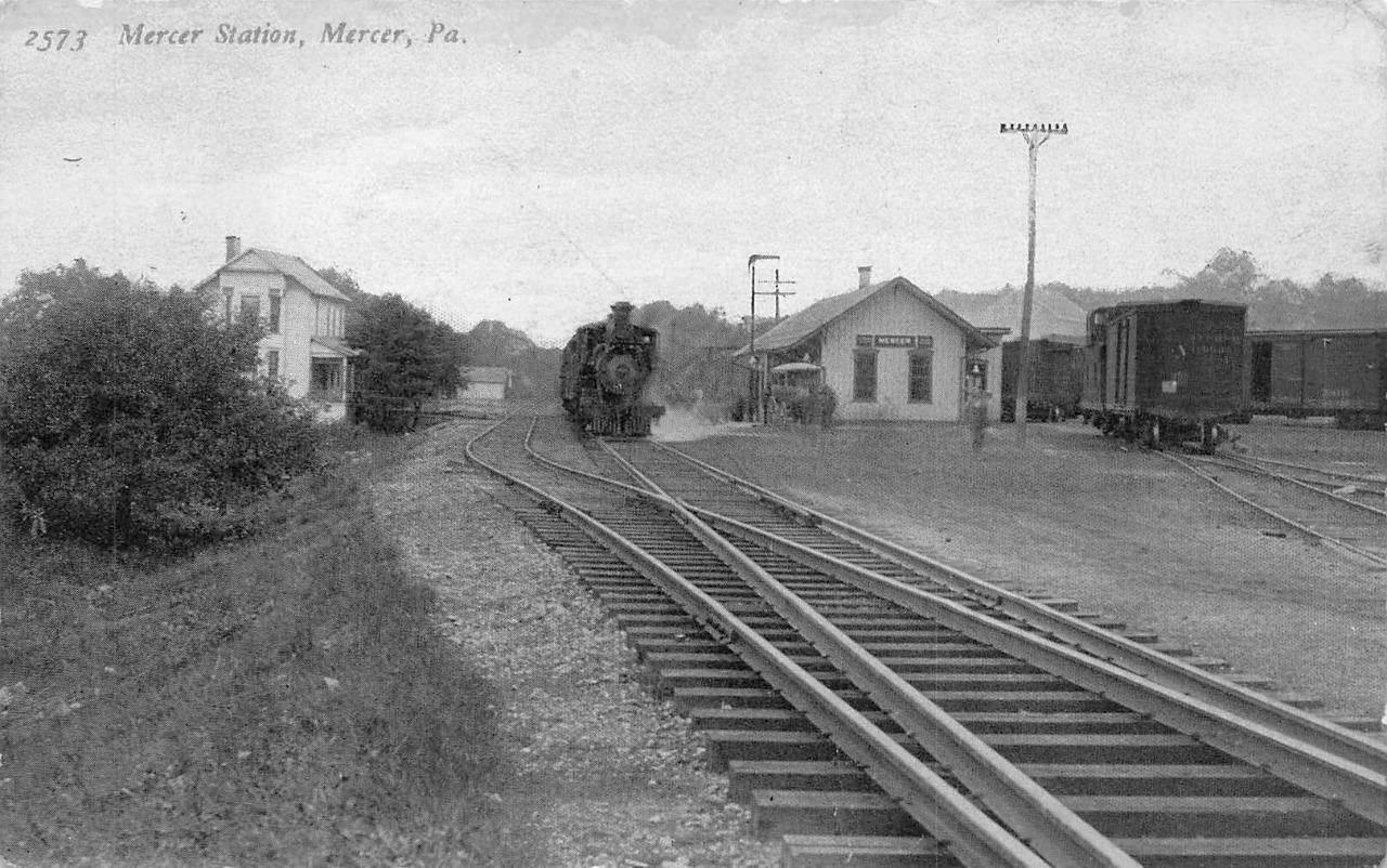
| Mercer |
|
This station was on the north side of east Market Street on the NW side of the tracks at GPS: 41.226314, -80.225414 just across Munnell Run Creek. The station is shown on Sanborn Insurance maps through 1904. It was likely eliminated in the late 1910s as the PRR station started to serve both railroads. | ||||||
| Mercer |
AND |
This WNY&P (PRR) station was on the south side of East Market Street at approximately GPS: 41.225381, -80.225693. This station is shown on the 1904 map. Prior to that, the station appeared a bit to the west (closer to Butler Street) so this station may have been a replacement built in the early 1900s. During WWI both the PRR and B&LE used this station and the Houston Junction B&LE and Mercer Junction stations were closed (Greenville Record-Argus, 8-23-1918). Thereafter it become a "union" depot. | ||||||
| Mercer Station (OAkland City) |
|
There was an early Shenango & Allegheny RR station here as shown on the 1873 map. It was on Oakland Road at approximately GPS: 41.237343, -80.218846. Quite a big town was plotted out here at that time, but it did not take off. The depot burned down in late 1885 and a new station was built in 1886 (Conneautville Courier, 1-8-1886). | ||||||
| Mercer (NC&F Crossing) |
|
The 1880 Shenango & Allegheny RR timetable indicates that there was a station at the crossing. | ||||||
| Millburn |
|
This station was on Millburn Road at approximately GPS: 41.168702, -80.227523. | ||||||
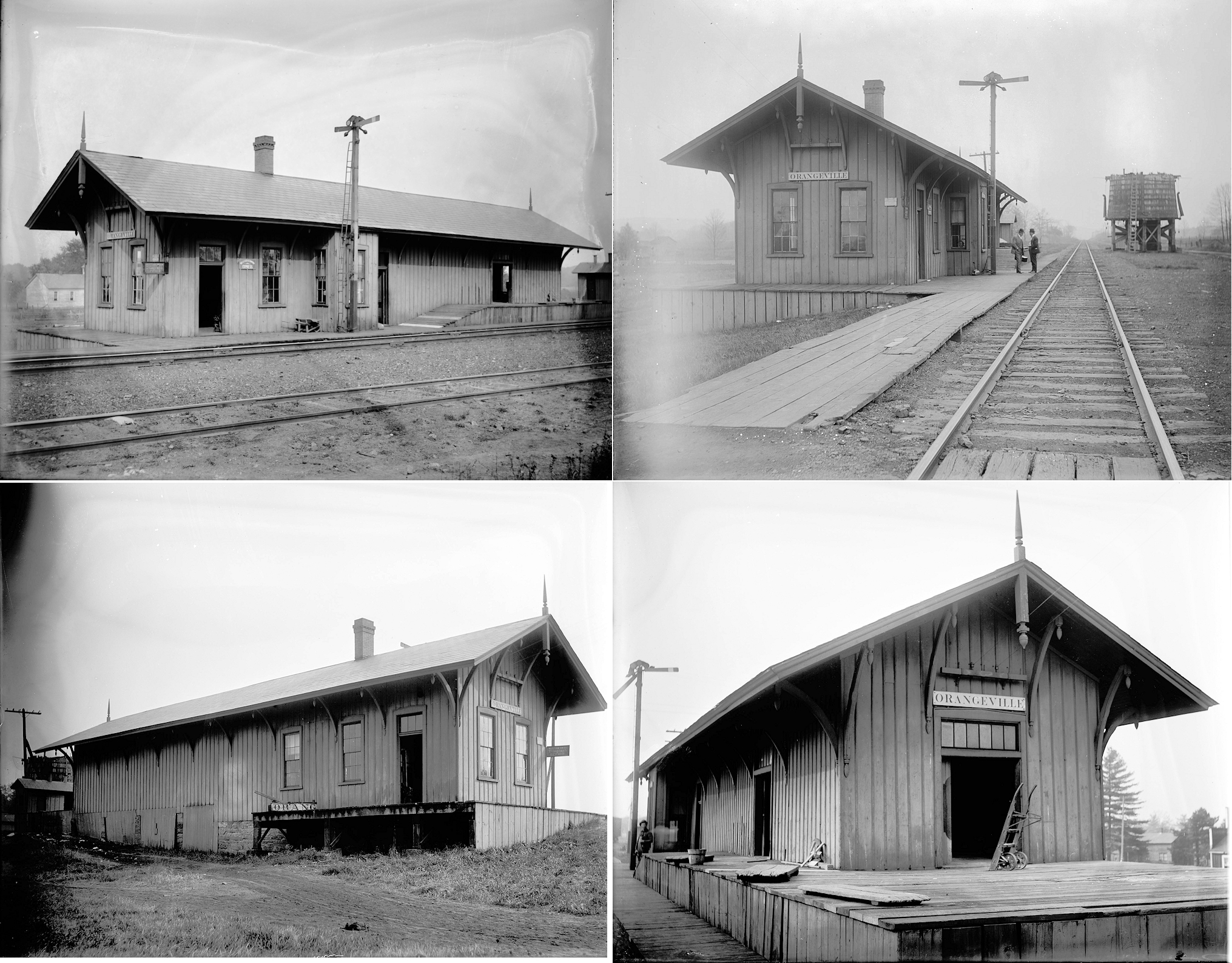
| Orangeville | |
Although the village of Orangeville is in Ohio, the station was located east of the state line in South Pymatuning Township on the township road that follows the state line. It was at approximately GPS: 41.337280, -80.518987. The first station here, according to the 1873 map, was on the east side of the road on the north side of the tracks. | ||||||
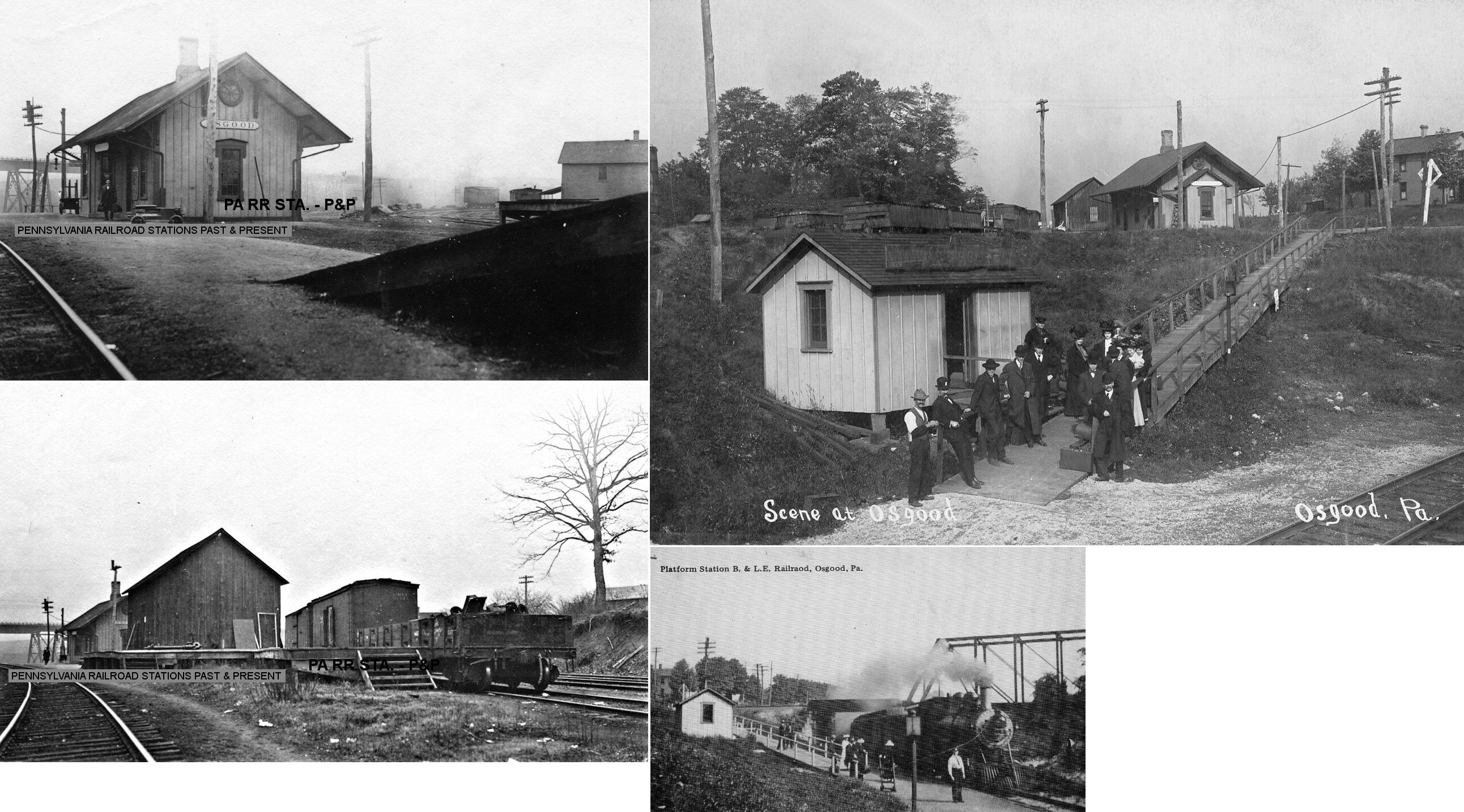
| Osgood (Amasa Crossing) |
|
This station was near where the Erie crossed the LS&MS line off Werner Road at approximately GPS: 41.440698, -80.364483. | ||||||
| Osgood |
AND |
This station was off Werner Road at approximately GPS: 41.441956, -80.368651. It measured 20'x40' and was built in 1891. NYC records say this station was shared 50/50 with the B&LE in terms of ownership although it is clear the station is of LS&MS design. The B&LE had two lines here, one on the trestle visible in the photo and a lower grade that crossed under the LS&MS tracks. B&LE passengers bought their tickets at the station and then used a long wooden sidewalk that took them down the hill to a B&LE waiting shelter. | ||||||
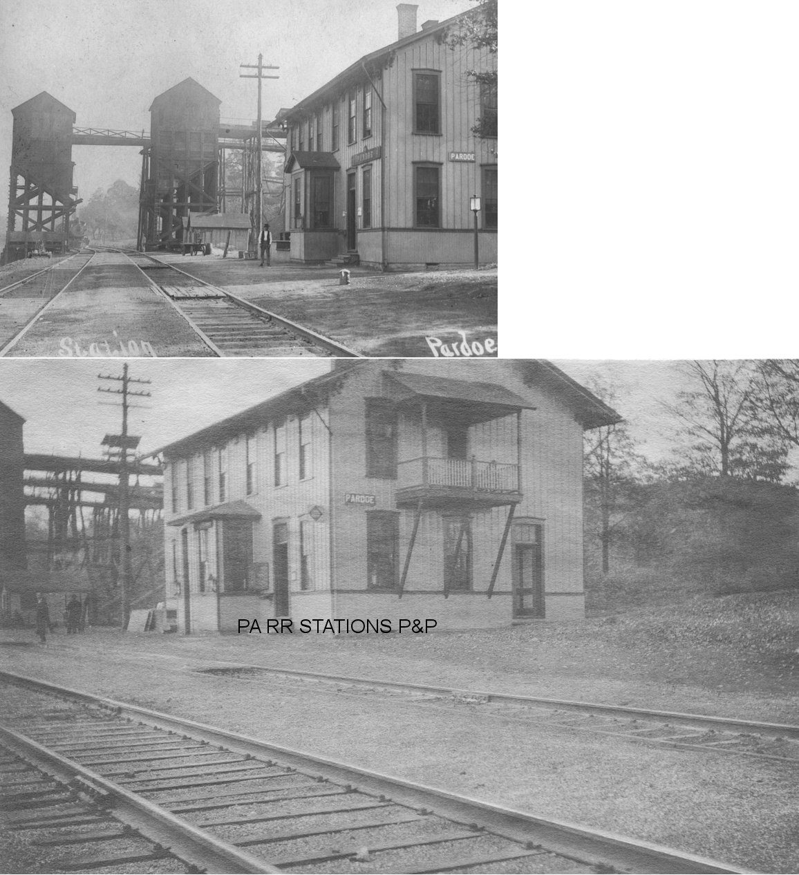
| Pardoe |
|
In 1873 a new station was built on the north side of Buckley Road (formerly Main Street) on the west side of the tracks at GPS: 41.218201, -80.140130. At that time the line was the Shenango & Allegheny RR. The station was on the first floor with agent's dwelling on the second. | ||||||
| Pinegrove |
|
This is shown as a station on the 1880 timetable of the Shenango and Allegheny Railroad. A new station that measured 70'x20' was built here in 1882 (Shenango Valley News, 9-29-1882). | ||||||
| Pymatuning Station | |
This station was on West Lake Road at approximately GPS: 41.304191, -80.443788. | ||||||
| Reed |
|
This was an early station shown on the 1884 timetable. It would have been in the vicinity of the Pinchalong Road crossing east of Grove City. | ||||||
| Salem (Leech Corners) |
|
A Jamestown & Franklin RR station is shown here on the 1873 map. A new station measuring 8'x10' was built here in 1901. | ||||||
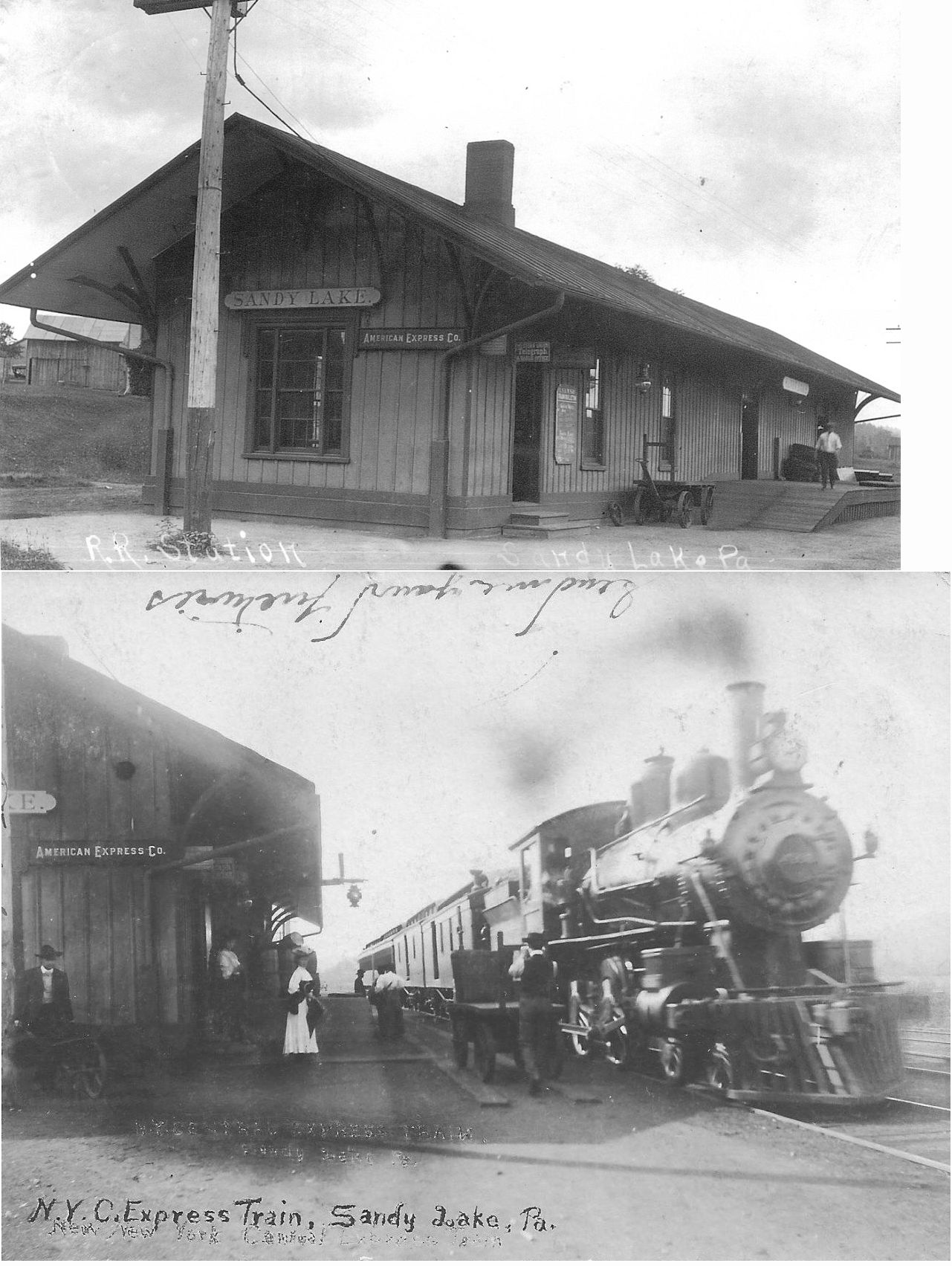
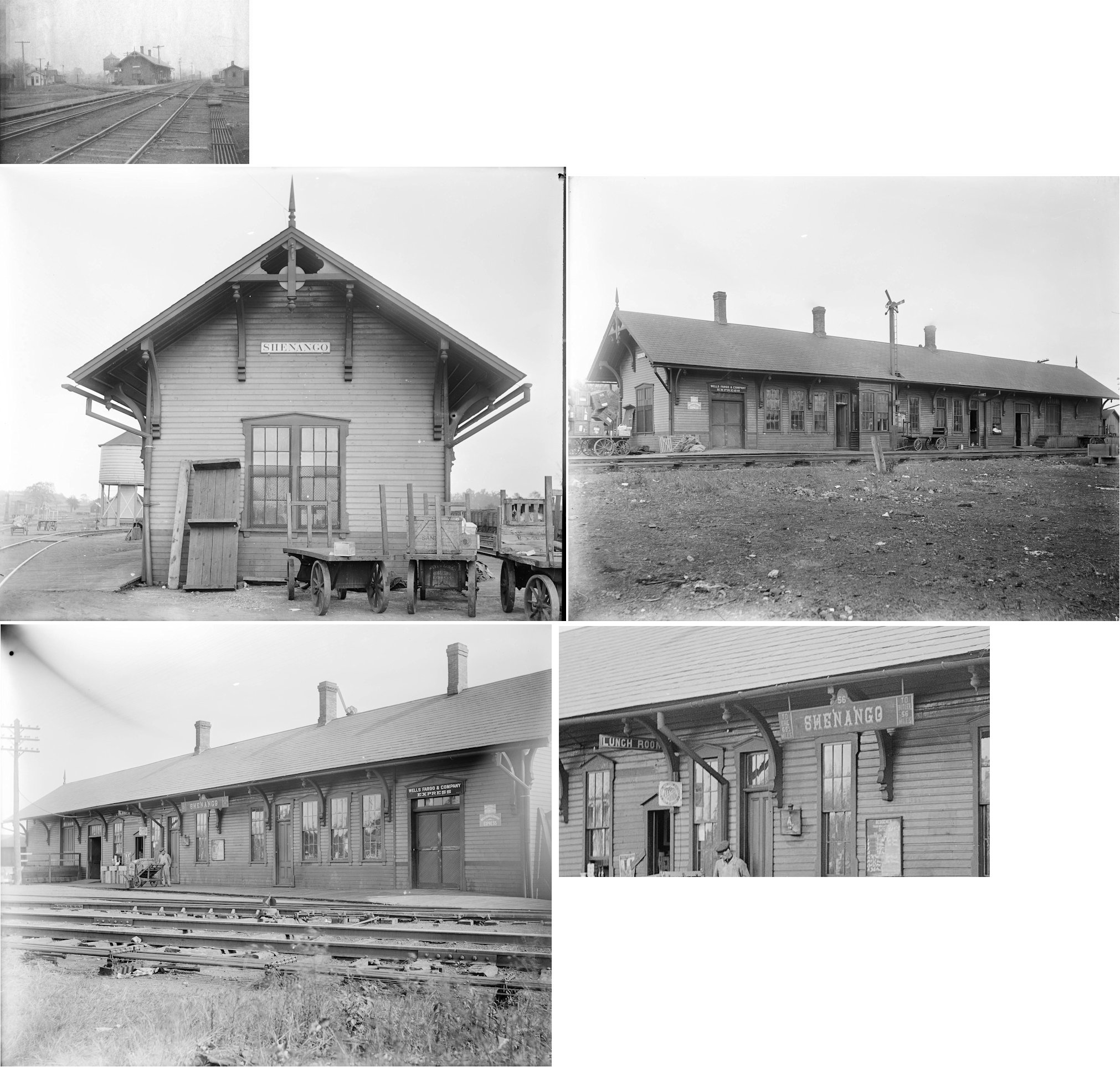
| Sandy Lake (Naples Sta.) |
|
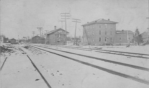
In 1873 the station was on what is now Railroad Street on the NE side of the tracks at approximately GPS: 41.348312, -80.083787. On the 1873 map, the station is also referred to as Naples Station. The NYC valuation records of 1919 say that this station was built in 1866 and measured 20'x98'. | ||||||
| Schollard (Schollards) |
|
This station was on Leesburg-Grove City Road at approximately GPS: 41.139799, -80.214216. This was on the PRR's Wolf Creek Branch at MP 1.9 (distance from Leesburg station). | ||||||
| Sharpsville |
|
IThis station was on the south side of the tracks between Walnut Street and Mercer Street at GPS: 41.264582, -80.475483. It was built in 1891. | ||||||
| Sharpsville |
|
An earlier station here burned down in 1902 (Conneautville Courier, 2-13-1902). | ||||||
| Sharpsville |
|
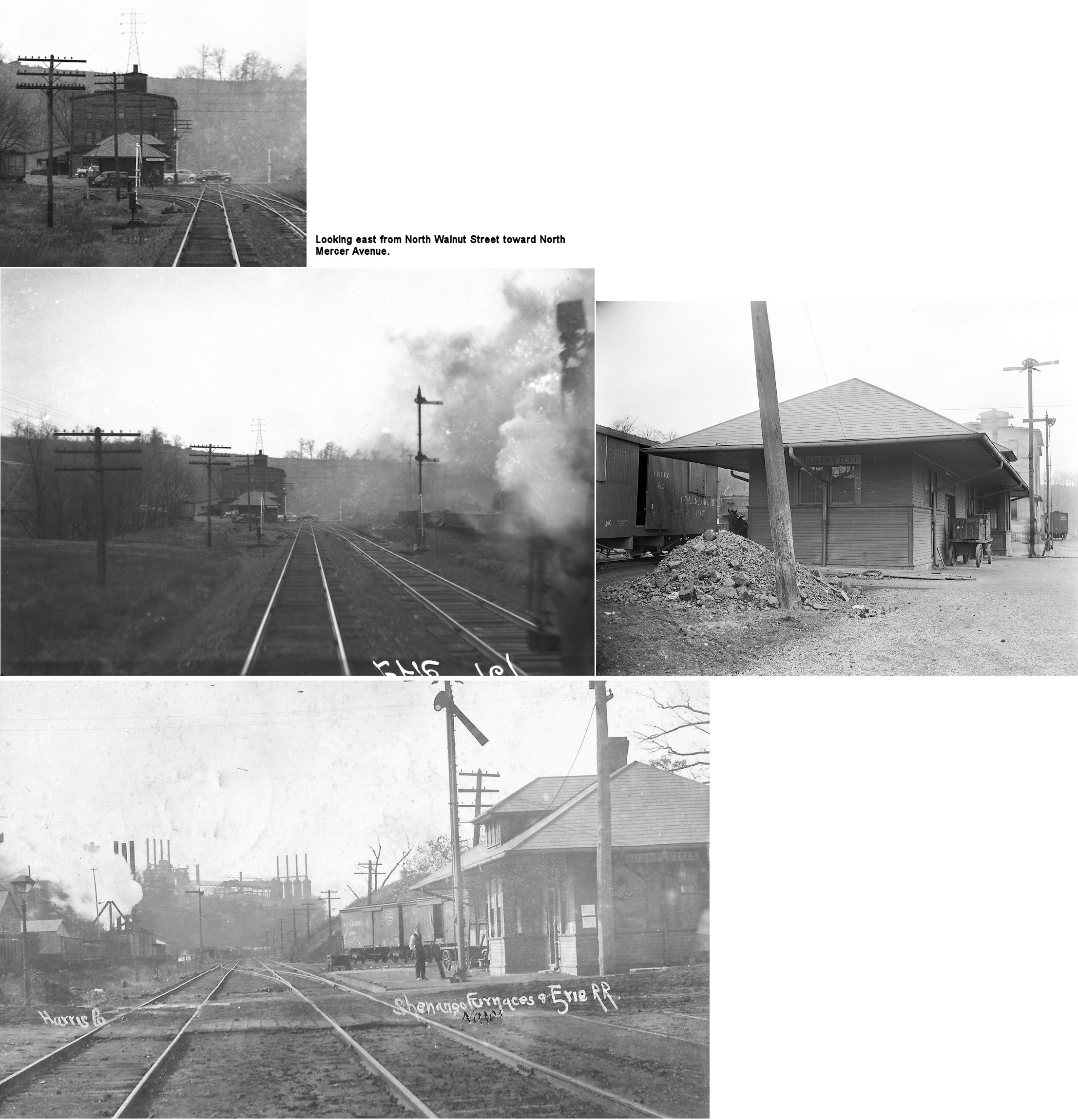
In 1905 the passenger station was on the SW side of North Mercer Avenue on the NW side of the tracks at GPS: 41.269433, -80.477907. The freight station was across the tracks on the SE side at GPS: 41.269366, -80.477798. These stations were likely built in 1902 after the previous station burned. The stations do not appear to have been in the same location in 1900, but maps don't show the area of town where they may have been then and prior. The Erie valuation records from 1919 list a build date of 1906. | ||||||
| Sharpsville |
|
A small passenger and a freight station were on the west side of Mercer Avenue on the NE side of the tracks at approximately GPS: 41.264613, -80.477189. These stations are shown on the 1905 Sanborn map listed as B&O stations (as the Sharpsville RR had come under B&O control by then). Although the station shown on the 1905 map was a single-story building, the station in the photo is two-story, so it may have been added on to or a new one was built sometime later. The bridge in the background of the photo is Mercer Avenue. | ||||||
| Sharon |
 |
Is this the original orginal E&P station? | ||||||
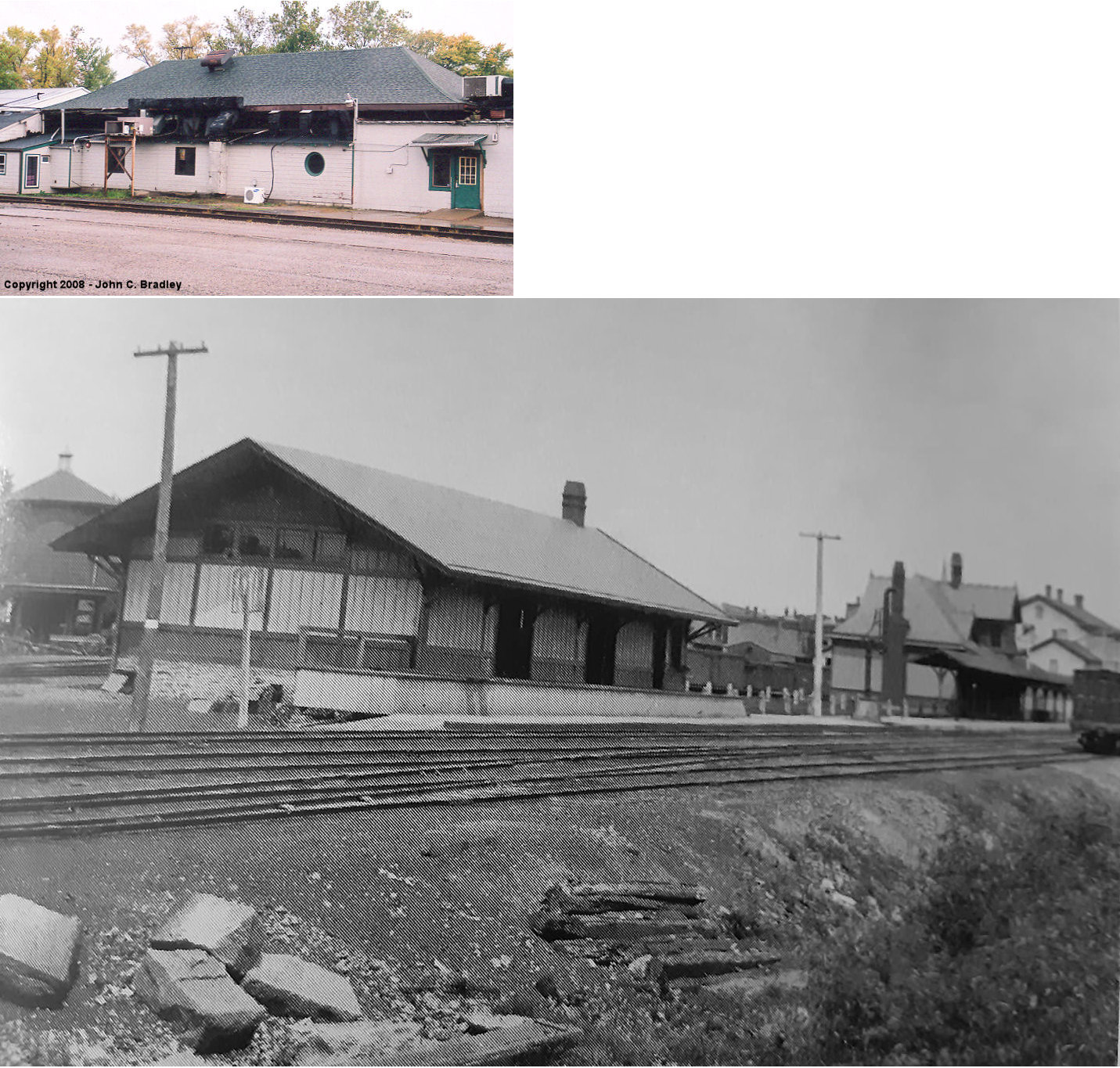
| Sharon |
|
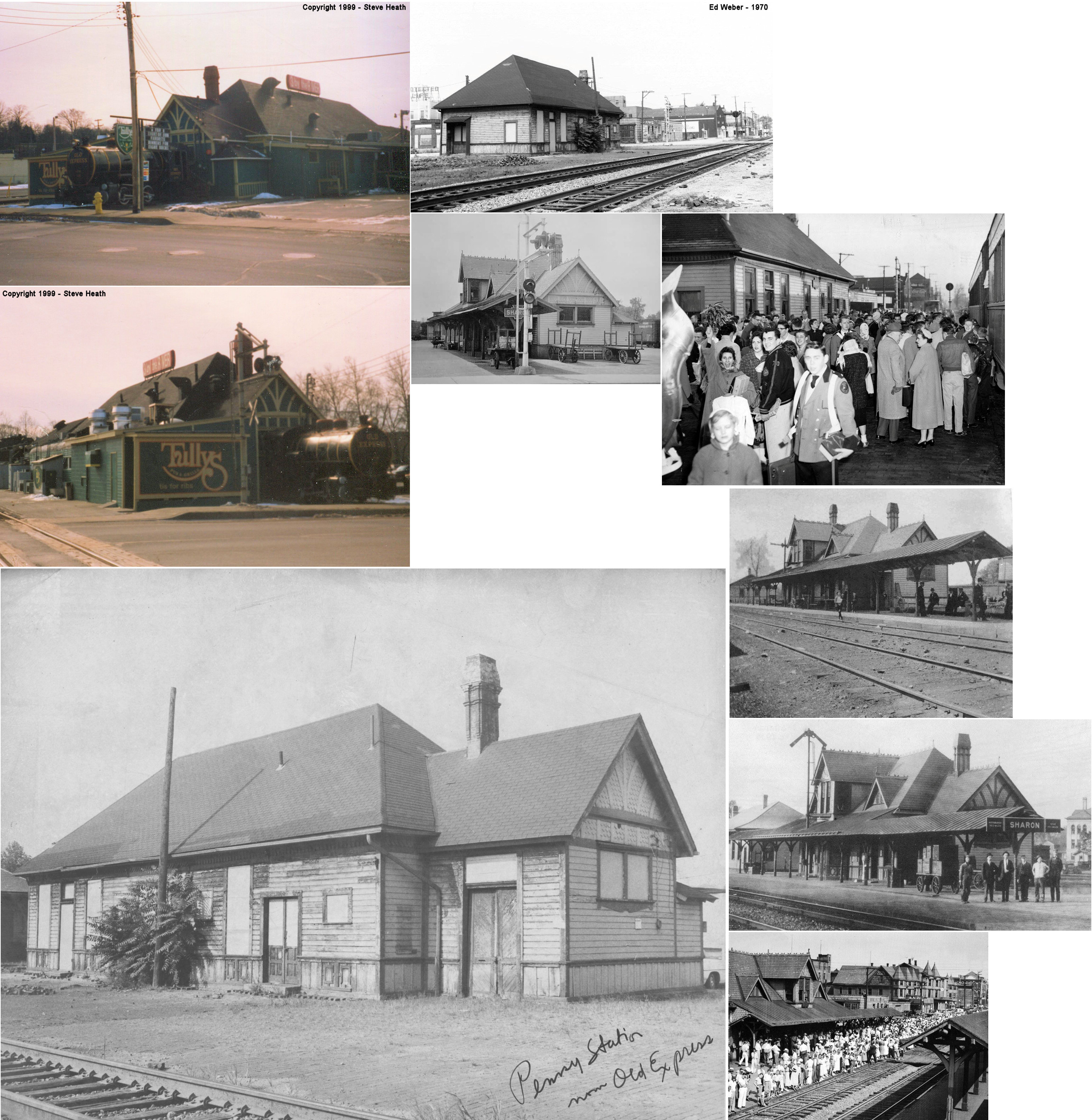
This passenger station was at 101 Chestnut Avenue (GPS: 41.231232, -80.507053). The passenger station, express office, and freight station were all part of the Tully's/Quaker Steak & Lube restaurant complex and obscured greatly by additions over the years. Built in 1887, the station was torn down in December 2017. | ||||||
| Sharon |
 |
The original station here was near the corner of Penn and Mill Streets at GPS: 41.238010, -80.511009. After passenger operations were moved closer to downtown, this building continued to serve as a freight station. It is shown on the 1888 Sanborn map. Both stations may have handled passenger traffic concurrently for a period of time. | ||||||
| Sharon |
|
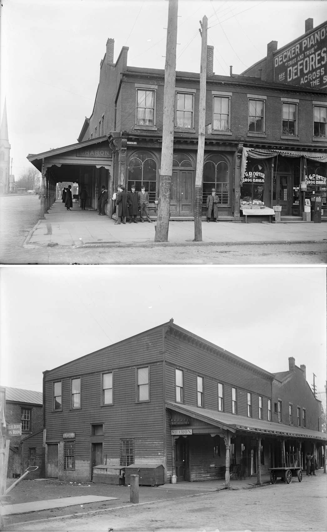
This passenger station was formerly two separate buildings that previously served as a dry goods store on the corner of Main Street and State Street (GPS: 41.233070, -80.512215). The station canopy on the side was added later when it became a passenger station in 1887 (according to Erie valuation records). The building in the front part was brick, whereas the rear section was wood frame (the canopy stretched down Main Street across the side of both buildings). Half of each floor was used as the station. The other half of the first floor was rented to a grocery store and the other half of the second floor was rented out as apratments by the railroad. Later, this building was replaced with the fully brick structure that stands today and served the Erie RR through the end of passenger service. | ||||||
| Sharon |
AND  |
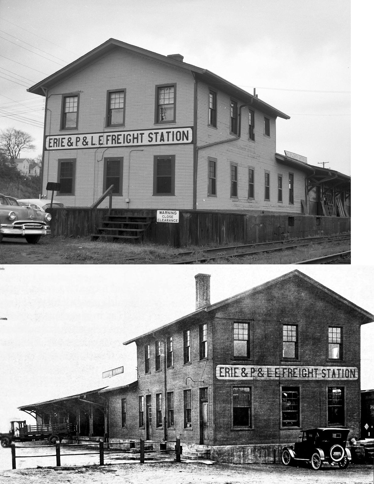
There was a shared freight house on the west side of South Dock Street at GPS: 41.230491, -80.506329. The station was built in 1911. The P&LE had trackage rights over the Erie's Ferrona Branch here. | ||||||
| Sharon |
|
This combination station was on the south side of West State Street on the west side of the tracks at GPS: 41.232690, -80.512694. The station is shown on Sanborn maps from 1888-1920. On the 1920 map, it is marked as only a freight station. The Valley Street Railway depot was across the street next to St. John's Episcopal Church. | ||||||
| Shenango |
AND |
There is a newspaper reference to the union station here getting a new coat of paint in 1874 when the station was shared by the A&GW and the Shenango & Allegheny. | ||||||
| Shenango |
AND |
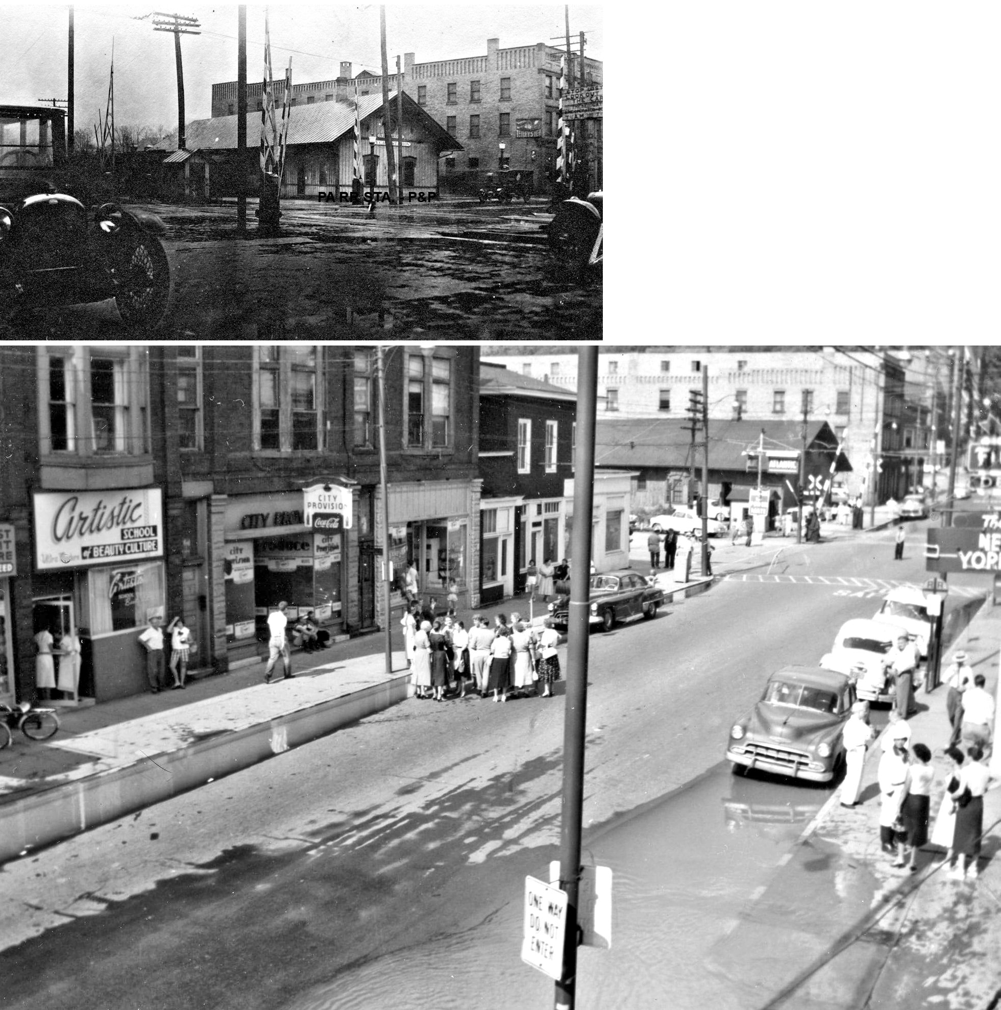
This station, built in 1882 according to valuation records, was on the east side of PA18 on the west side of the Erie tracks at GPS: 41.378081, -80.396320. The E&P station can also be seen on the left in the top photo. The Shenango A&GW station was essentially the second large station on the same line in Greenville as the Shenango station was a mere two miles SW of the Greenville station. Many residents on the south and west sides of Greenville could just as easily depart from either station. With each new timetable released by the railroad, Greenville area travelers had to navigate different trains leaving and stopping at one or the other depot (or both). To further complicate matters the Erie & Pittsburgh RR also had stations at Greenville and Shenango (at Shenango they were practically adjacent) so juggling the best and most cost effective travel arrangements to and from Greenville must have been a challenge. The station was built by the A&GW and the 1919 Erie valuation records say the station was then owned 2/3 by the Erie and 1/3 by the B&LE. B&LE passenger service ended at this station on Nov. 15, 1929. No stations are left at Shenango and the area where the stations were isn’t even accessible by road anymore. | ||||||
| Shenango |
|
This station was on the east side of PA18 on the west side of the tracks at GPS: 41.378271, -80.396954. | ||||||
| Shenango |
|
The B&LE may have shared the Erie station here. | ||||||
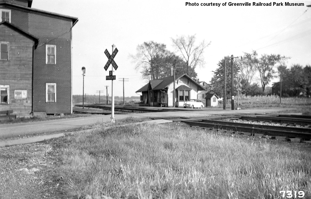
| Stoneboro |
|
There was a freight station on the north side of the tracks north of Railroad Street at GPS: 41.342153, -80.106664. The building measured 24'x97' and was built in 1875 according to NYC valuation records of 1919. | ||||||
| Stoneboro |
|
The 1923 PRR List of Stations & Sidings lists a station here, but it is not clear if it was shared with the LS&MS. | ||||||
| Sugar Grove (Kennard) |
|
An Atlantic & Great Western station is shown here on the 1873 map. The station was on Groover Road at approximately GPS: 41.465311, -80.336611. The station was made of an old boxcar and was placed there in 1890. The name was changed by the railroad to honor Thomas W. Kennard. | ||||||
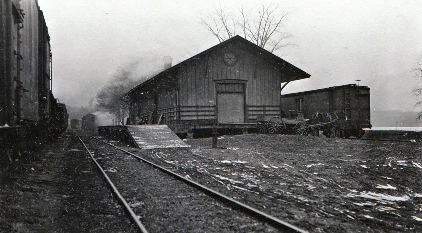
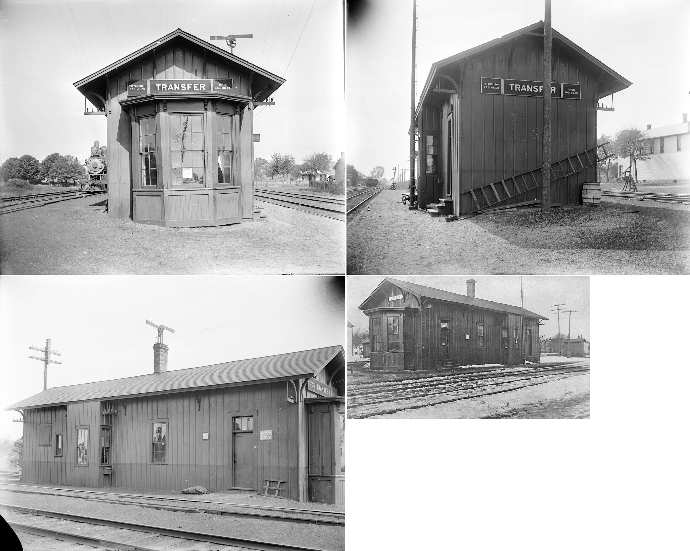
| Transfer |
AND |
This station was between the tracks on the south side of Edgewood Drive Extension at approximately GPS: 41.329668, -80.432475. It was built in 1865. The nearby freight station was built in 1882. | ||||||
| Turners |
|
This station was at mile post 26.4 (distance from Mahoningtown station) and 2.4 miles from the station at Mercer. The Jackson Sand & Stone Company was .2 miles from the station. A station is shown here on the 1923 PRR List of Stations & Sidings. | ||||||
| Valcourt (Breckenridge) |
|
This station was on the PRR's Wolf Creek Branch at MP 8.1 (distance from Leesburg station). The PRR changed the name of this station from "Breckenridge" to Valcourt in January 1905. | ||||||
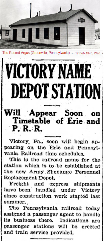
| Victory (Camp Reynolds) |
|
|||||||
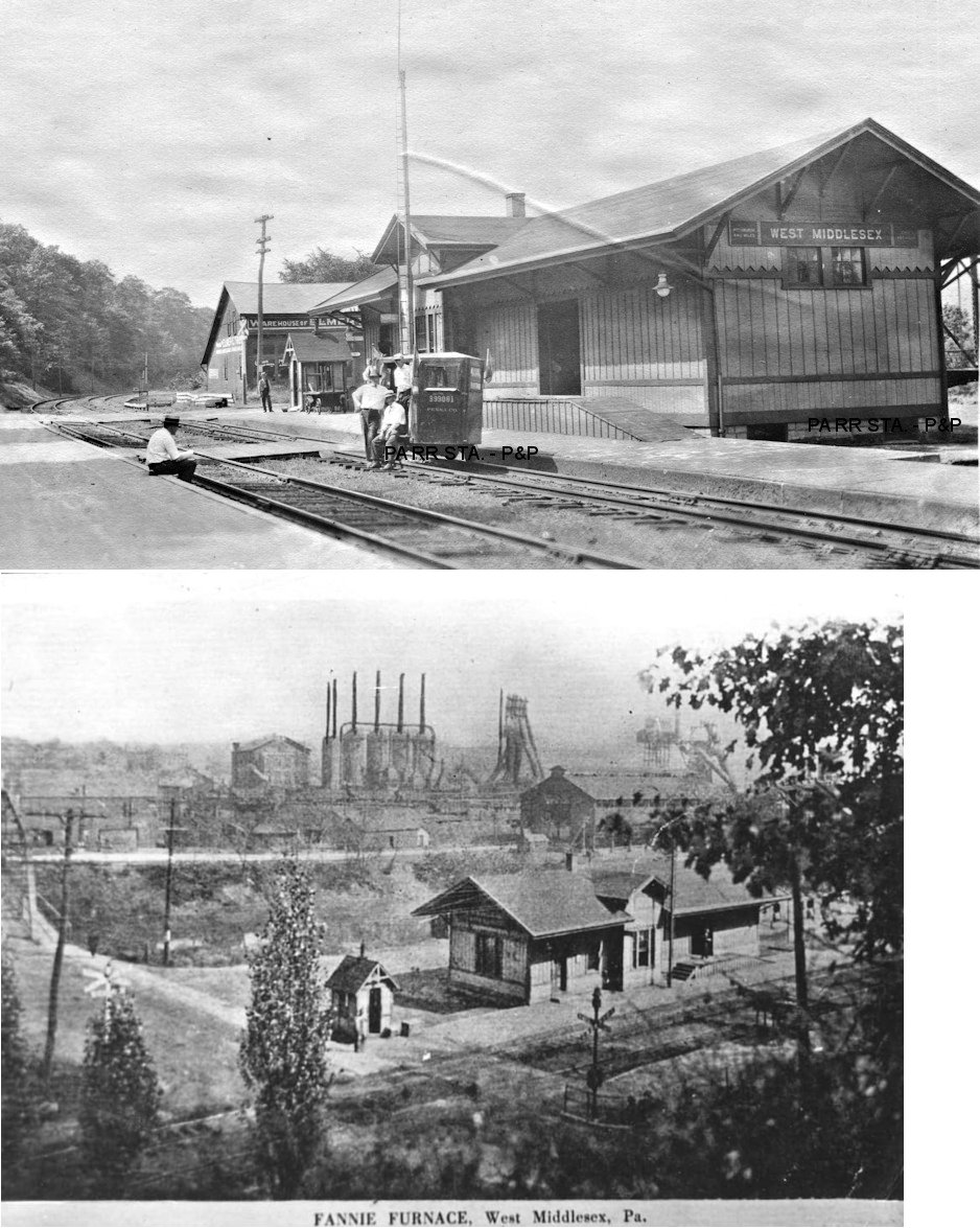
| West Middlesex |
|
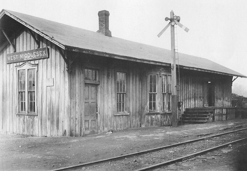
This station was on the south side of Main Street (Hubbard Road) just past the west end of the bridge at approximately GPS: 41.172050, -80.459951. The first station here was considerably south of the Main Street bridge at around GPS: 41.170063, -80.457549 along what is now Penn Avenue. That station burned down in June 1871 and was replaced with a similar structure soon after (Greenville Advance, 6-10-1871). That station is shown on the 1873 map. The railroad changed the name of the station from Middlesex to West Middlesex in 1882. The photo here is the station that was built in 1871 (and taken around 1919). The station burned down in April 1921. The fire was ignited by burglars who blew the lock off the safe which contained only a few dollars. The depot had been targeted by burglars several times previously that year. The 1921 map shows a configuration of three small narrow structures (likely old boxcars), labeled "passenger and freight depot," just south of where the station had been on the 1912 map. | ||||||
| West Middlesex |
|
This station was at the SW end of North Street on the east side of the tracks at approximately GPS: 41.173587, -80.459839. The station was built in 1890 according to Erie RR records from 1919. | ||||||
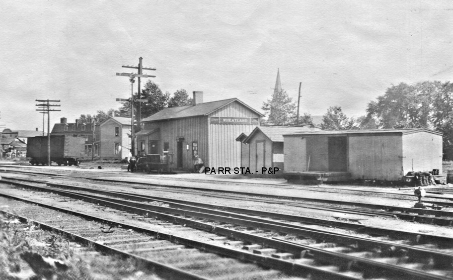
| Wheatland |
|
In 1873 the first station was on the north side of Ohio Street on the NE side of the tracks at GPS: 41.198953, -80.500900. The second station, pictured, was built in 1880 and had a converted boxcar for a freight house. | ||||||
| Wheatland |
|
|||||||
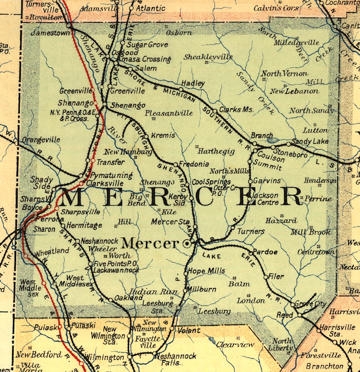
| 1895 MERCER COUNTY RAILROAD MAP | ||||||||
 |
||||||||
| Notes About Existing
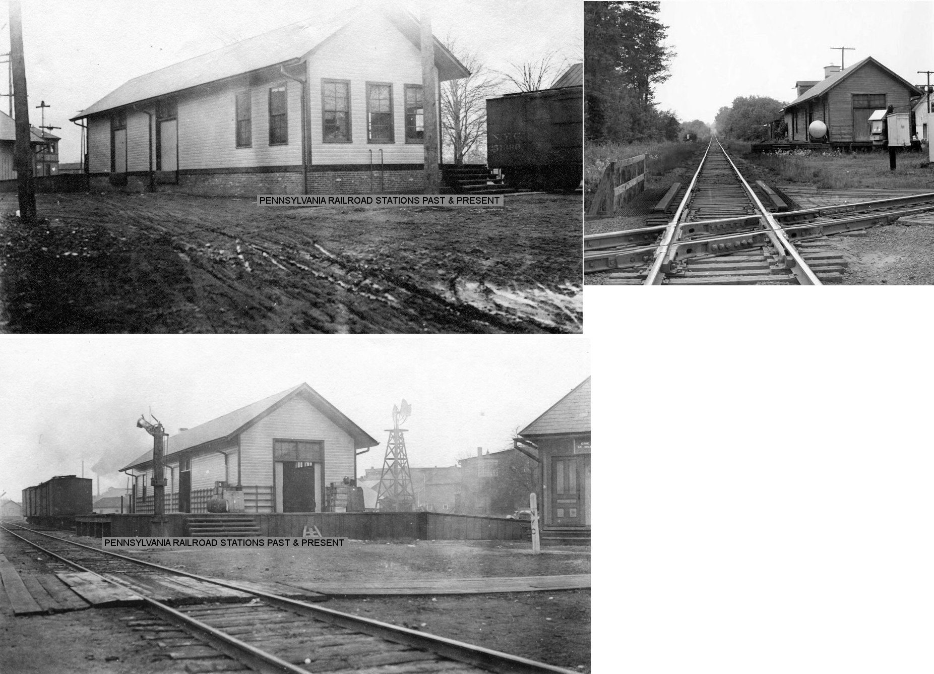
Stations... Bethel (Sharpsville RR) - Station has been modified and is amidst trees. Greenville (Erie) - This was the second A&GW station here (not counting a temporary station that preceded it). It was built in 1872 (opened in October of that year) and also served as the station for the Shenango and Allegheny Railroad (the forerunner of the B&LE) prior to that line building a station in town. According to the Greenville Argus of 8-16-1873, the S&A ended at Shenango at that time but connections (not sure which lines were used) were made to the A&GW depot at Greenville for continuous service effectively making the A&GW station the Greenville departure point for the S&A. Around 18 S&A trains per day left the depot. The station was extensively renovated in 1954 with new doors, windows, brick work and paint. The floor was raised 4 inches and the ceiling was lowered to 12 feet (Greenville Record Argus, 1-30-1954). Passenger service ended in 1970. Greenville (B&LE) - Passenger service ended in 1955. Jamestown (LS&MS) - The Jamestown LS&MS depot dates to 1872. There may have been an earlier station here as the line from Jamestown to Franklin opened on June 27, 1867 (Greenville Record Argus, 7-3-1909). After seeing duty as a feed mill post-retirement, the 1872 station served as a woodcarver's gallery from 1995-2011. The station used to be on the south side of the tracks at GPS: 41.483005, -80.438884). Oakland Station (Sharpsville RR) - This was the old Rollinson Store, although not owned by the RR it served as the station. The building burned in 1925 and was rebuilt in 1927. The railroad closed in 1931. Sharon (Erie) - This station was part of a corner commercial building and is not a traditional style stand-alone station. The building has been heavily modified and isn't much for looking at. It used to have an overhanging roof on the track side of the building that was removed sometime between 1990-2000. Stoneboro (LS&MS) - NYC sold this station to a local woman who had it moved from its original site at the foot of Lake Street (GPS: 41.341701, -80.107113) to a point off railroad property, maybe 500 feet further west along the right of way. The folks in Clarks Mills acquired it for an arts and crafts shop probably 15 years ago. They numbered each board and reassembled it on its present site. They did remove three feet from the base of the building, so it is shorter than its previous life, but probably easier to heat. NYC built a bay window on the freight house across the track [from original passenger station site], and the agent/operator did his thing there as long as the agency was open. Conrail then demolished freight station. The NYC valuation records of 1919 say that this station was built in 1866 and measured 20'x54'. |
||||||||