|
|
||||||||
| EXISTING STATIONS | ||||||||
|---|---|---|---|---|---|---|---|---|
| Station Name |
Original Railroad |
Current Location |
Type | Current Use |
Date Built |
Track Status |
Building Material |
More Info |
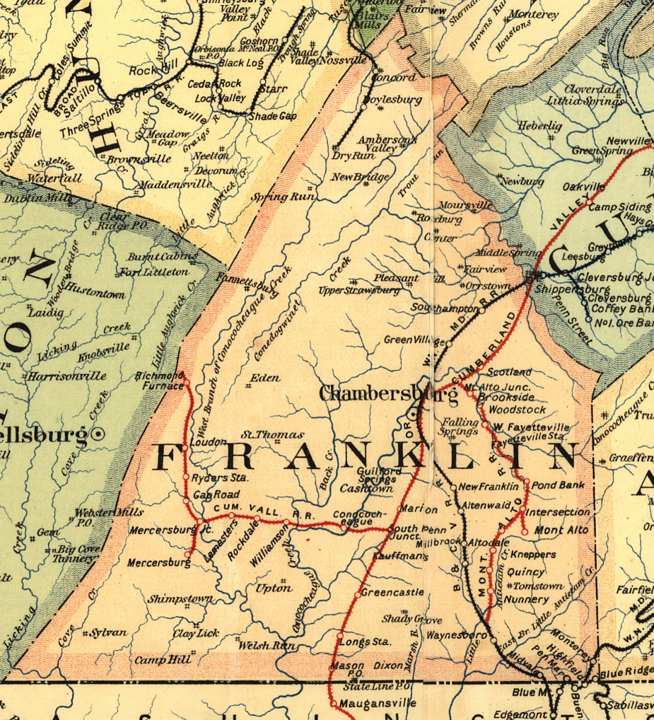
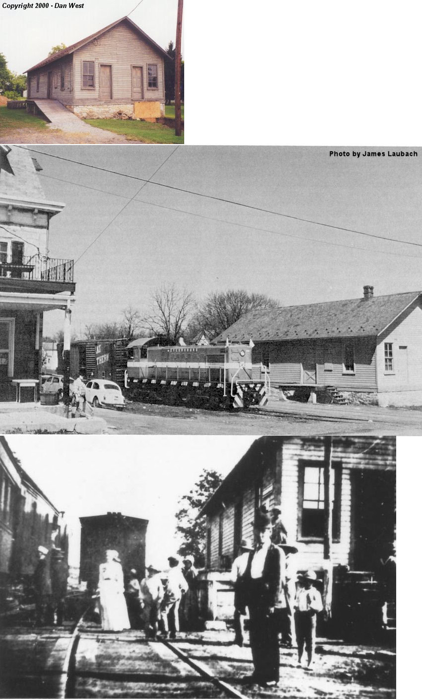
| Blue Ridge Summit |
 |
15055 Summit Plaza (GPS: 39.720769, -77.471355) |
P | Library | 1891 | In Use | Wood | |
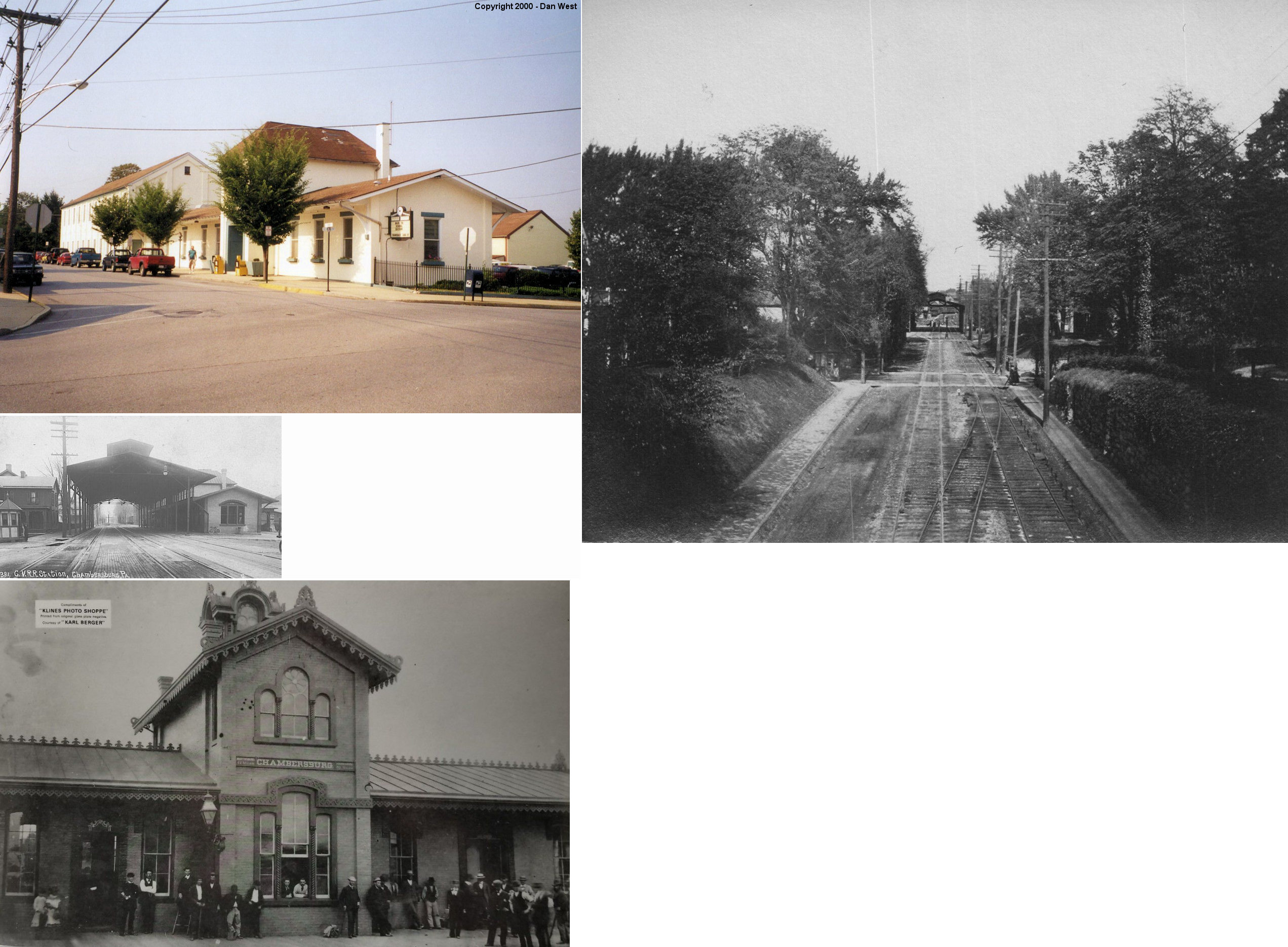
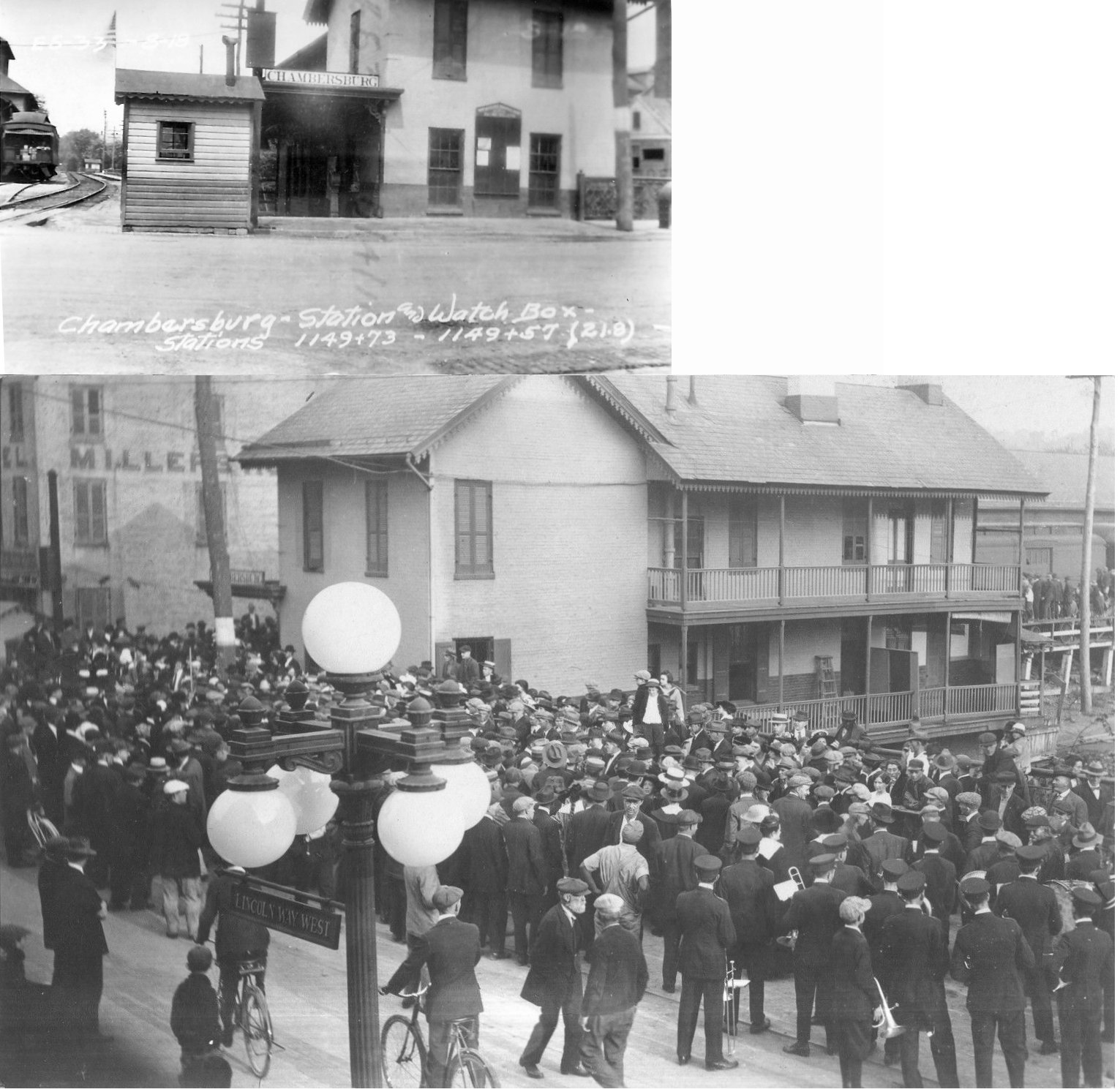
| Chambersburg |
 |
North 3rd & East King (GPS: 39.938369,-77.657024) |
P | Business | ???? | Gone | Brick/ Stucco |
|
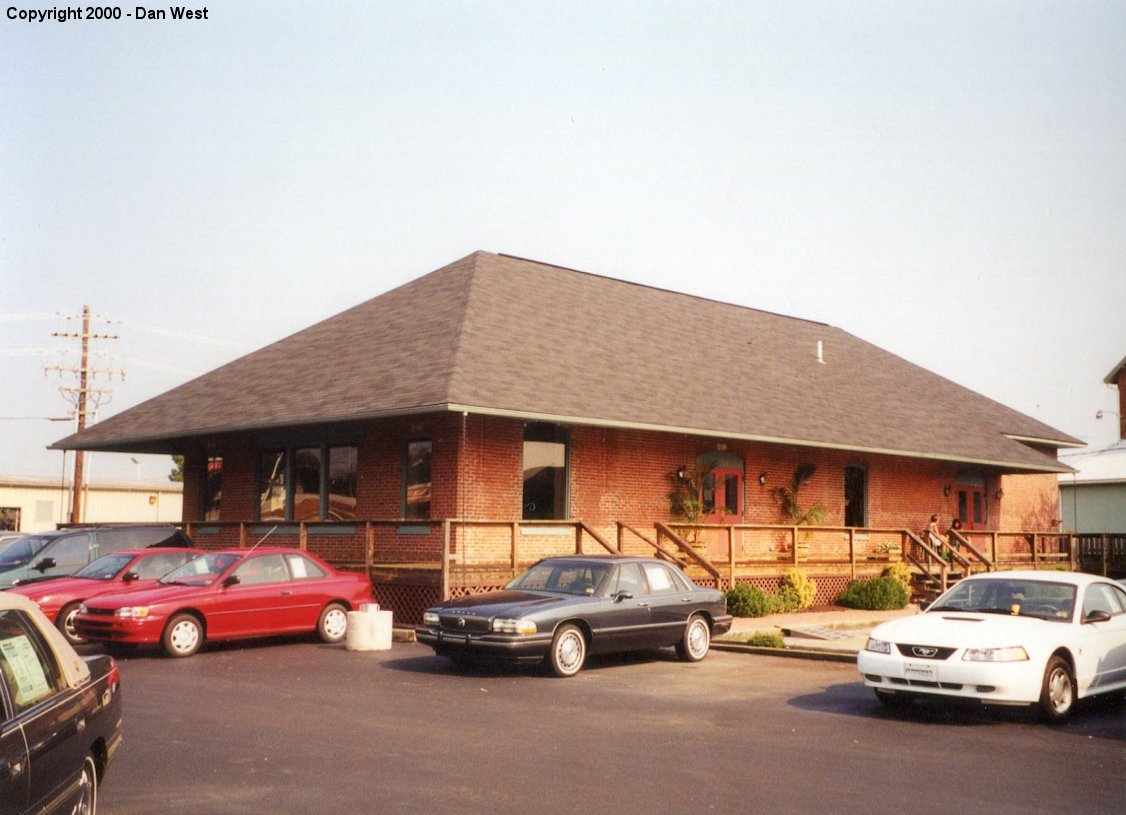
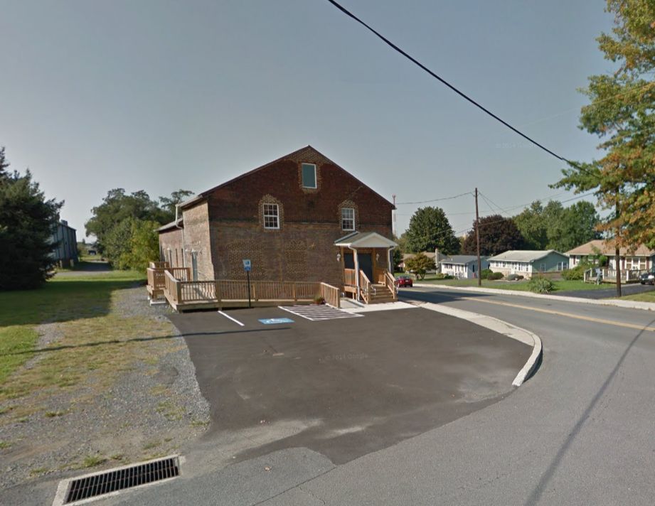
| Chambersburg |
|
342 Grant Street (GPS: 39.941496, -77.656170) |
F | Business | ???? | Gone | Brick | |
| Chambersburg |
|
Off Grant Street behind Jennings Chevy (GPS: 39.941852, -77.655938) |
F | Business | 1890s | Gone | Brick |
|
| Ft. Loudon |
|
210 Mullen Street (GPS: 39.914915, -77.906418) |
C | Library | ???? | Gone | Wood | |
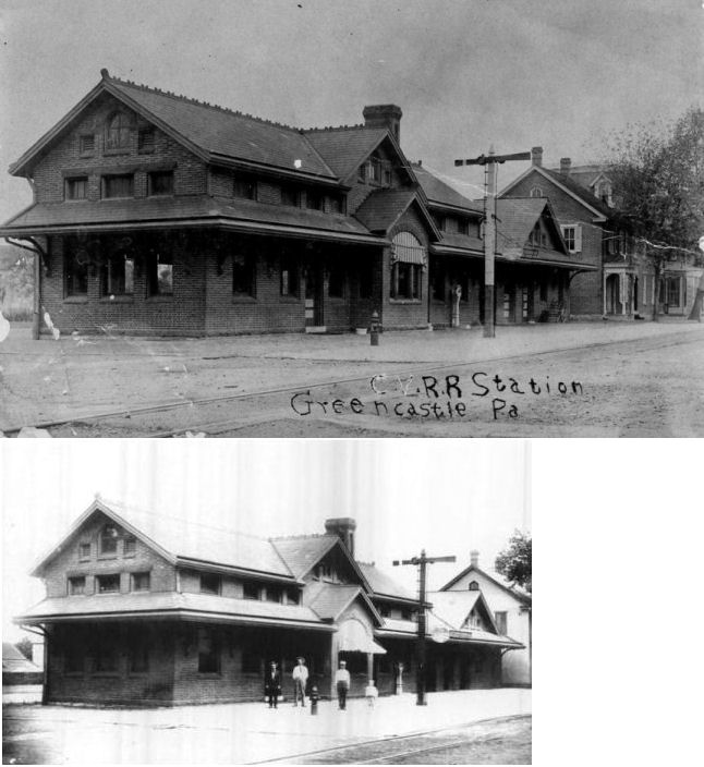
| Greencastle |
|
Jefferson Street between Buchannan Trail (PA16) and West Franklin
Street. (GPS: 39.790201, -77.730095) |
P | Civic | 1908 | In Use | Wood |
|
| Greencastle |
|
South Carlisle just south of Railroad Street (GPS: 39.785516, -77.729883) |
F | Business | ???? | Gone | Brick |
|
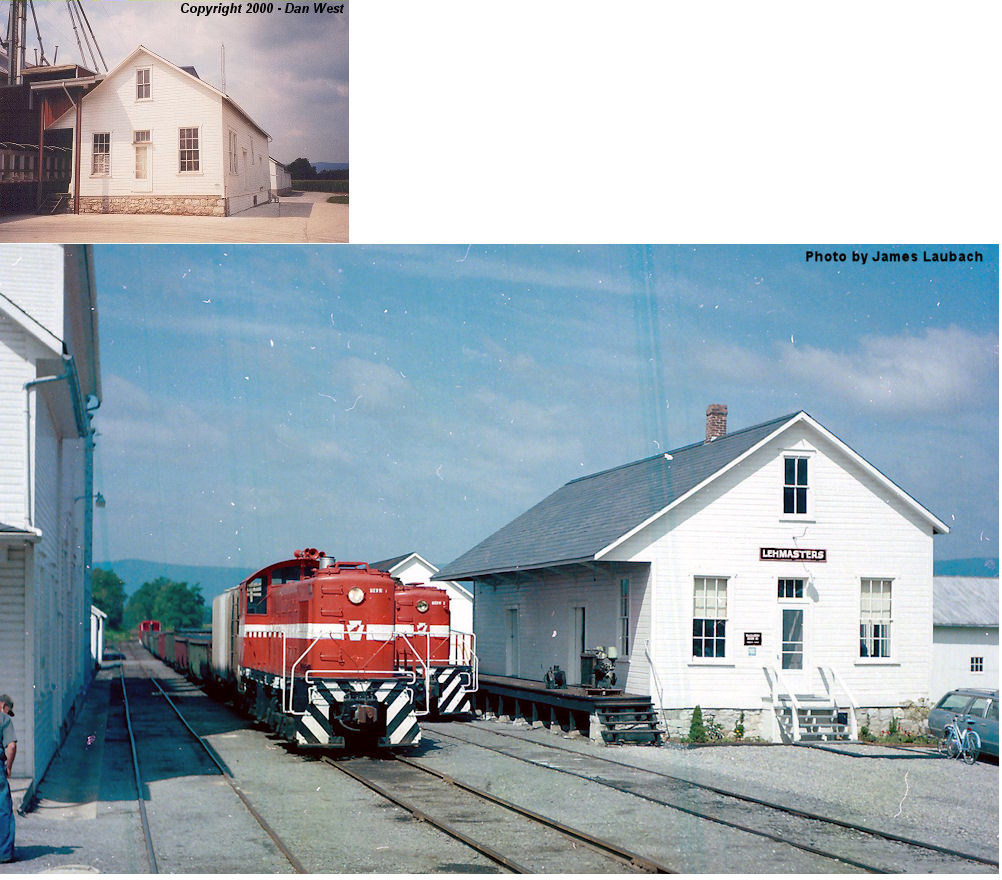
| Lemasters |
|
At Snider's Elevator at 4551 Lemar Road (GPS: 39.861769, -77.860846) |
C | Business | ???? | Gone | Wood | |
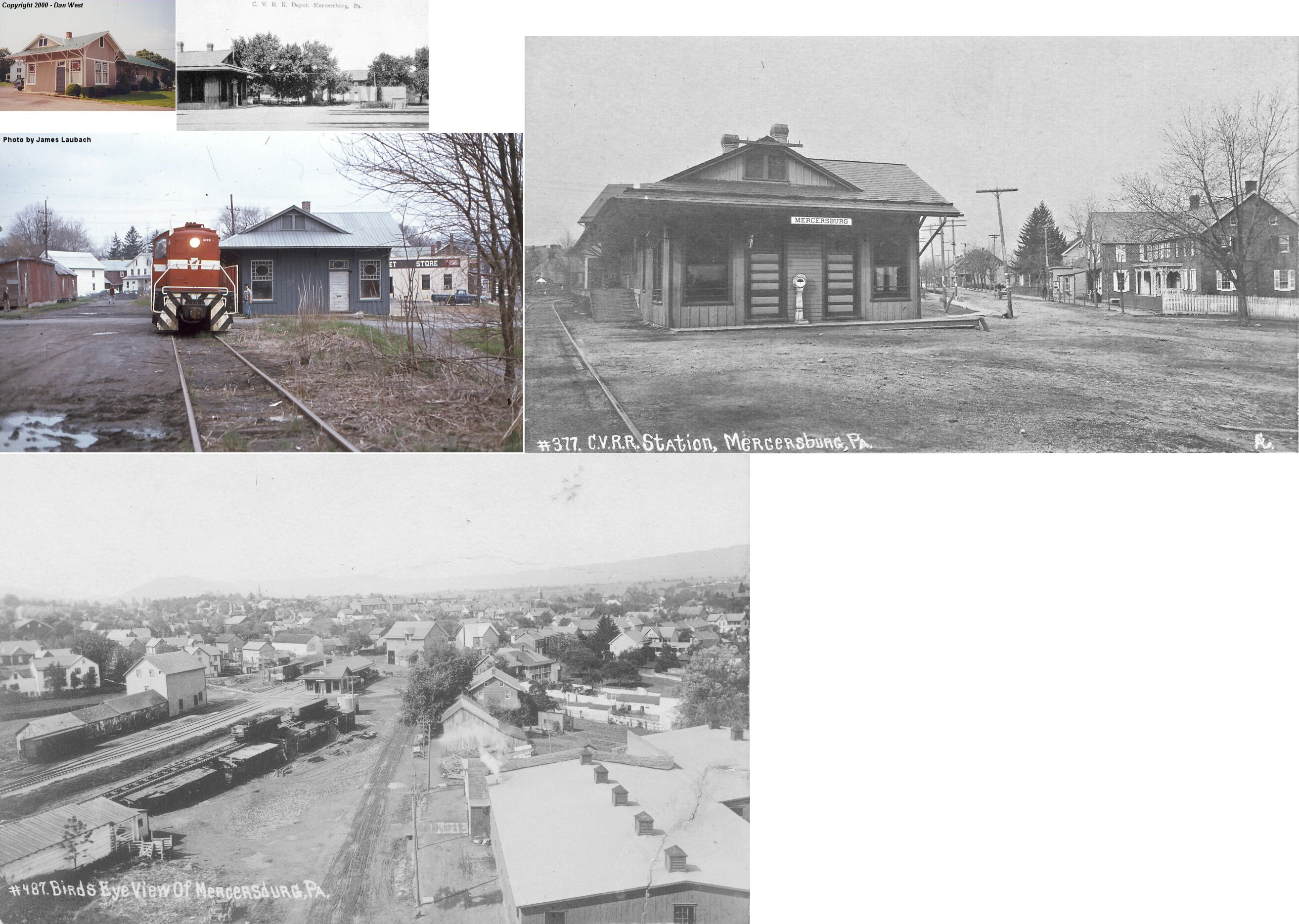
| Mercersburg |
|
Oregon & Church Streets (GPS: 39.830564, -77.900934) |
C | Business | ???? | Gone | Wood |
|
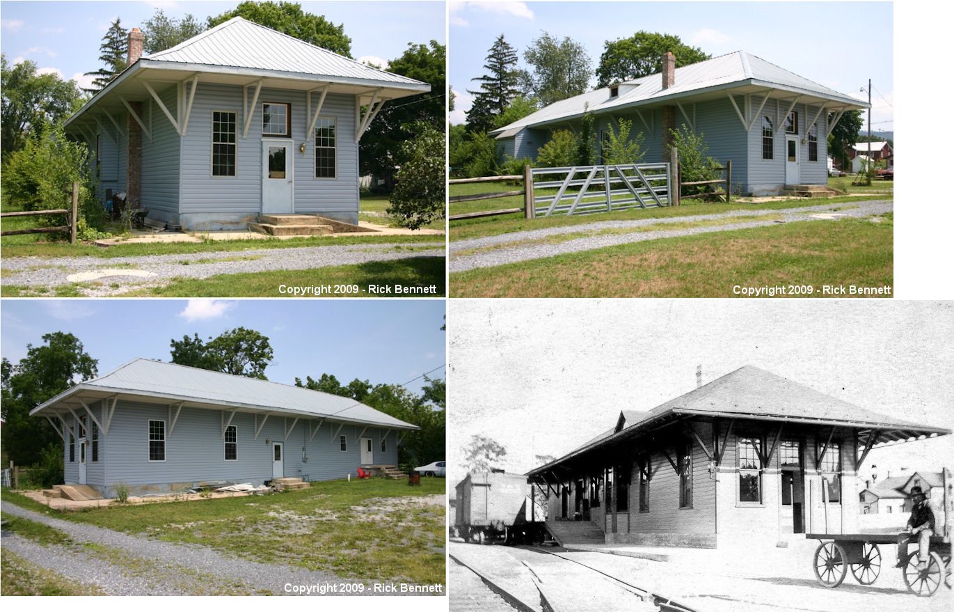
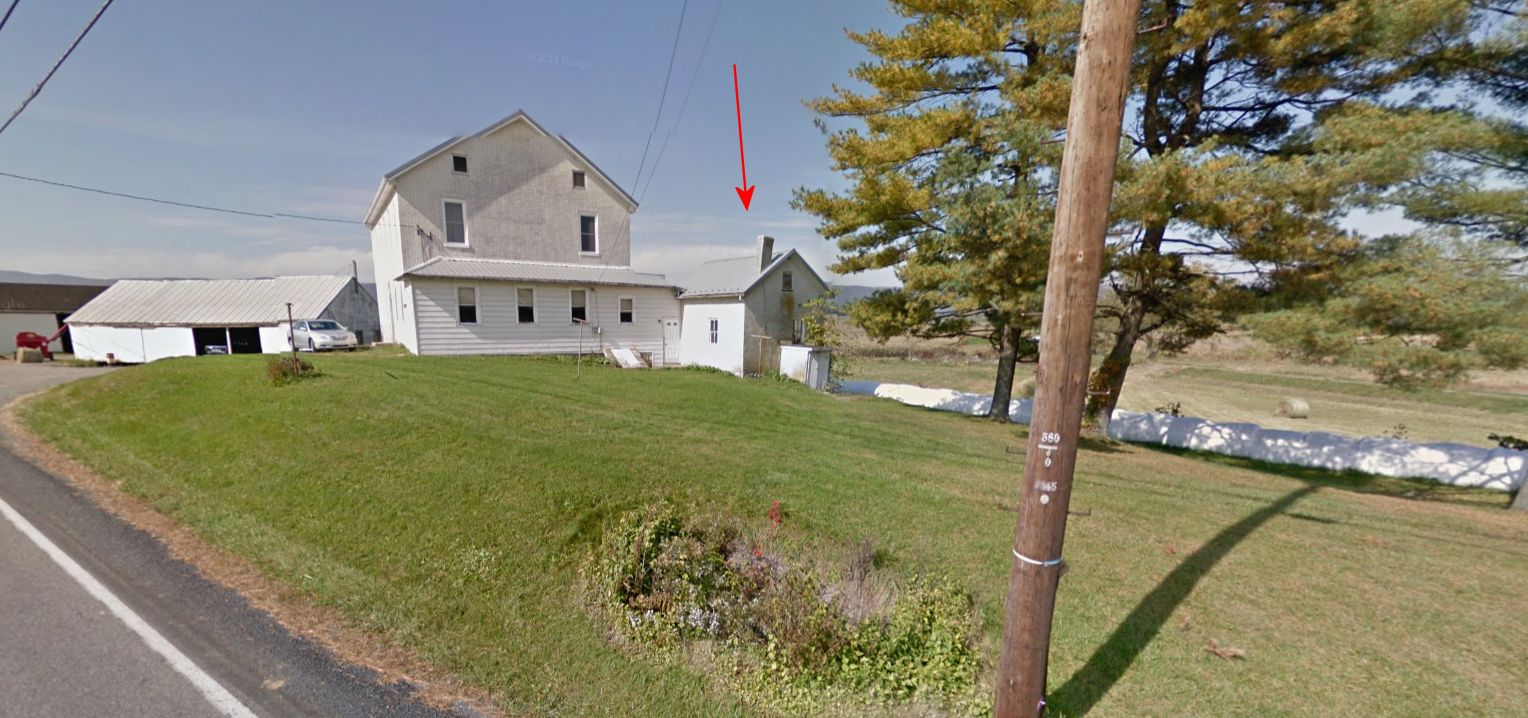
| Mont Alto |
 |
North side of Penn Street at Fir Street (GPS: 39.844642, -77.561144) |
P | Private | ???? | None | Wood |
|
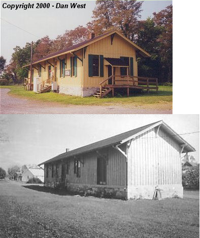
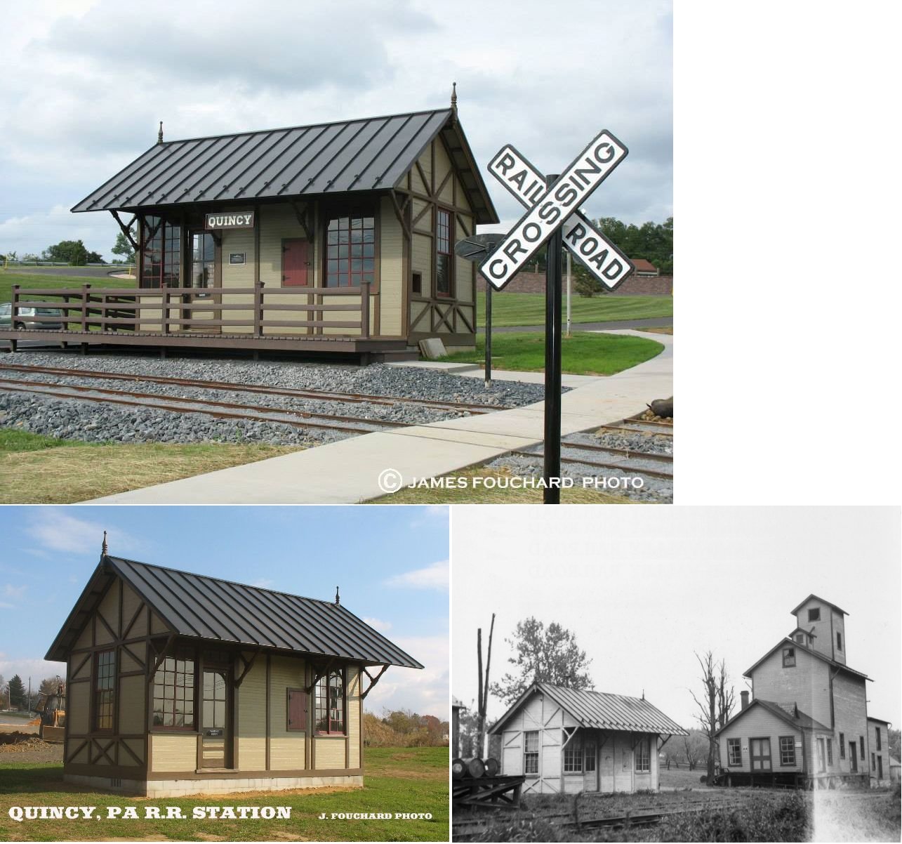
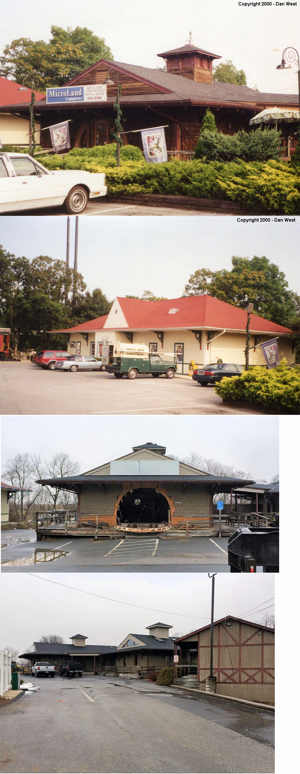
| Quincy |
|
South side of U.S. 30 in Norlo Park, Guilford Township, just outside
Fayetteville (GPS: 39.913777, -77.574438) |
P | Museum | ???? | None | Wood |
|
| Williamson |
|
North side of Cedar Street west of Franklin Avenue (GPS: 39.853175, -77.798221) |
P | Storage | ???? | Gone | Wood | |
| STATIONS OF THE PAST | ||||||||
| Station Name |
Original Railroad |
Notes | ||||||
| Altenwald |
|
This station was on Altenwald Road at approximately GPS: 39.844906, -77.604759. | ||||||
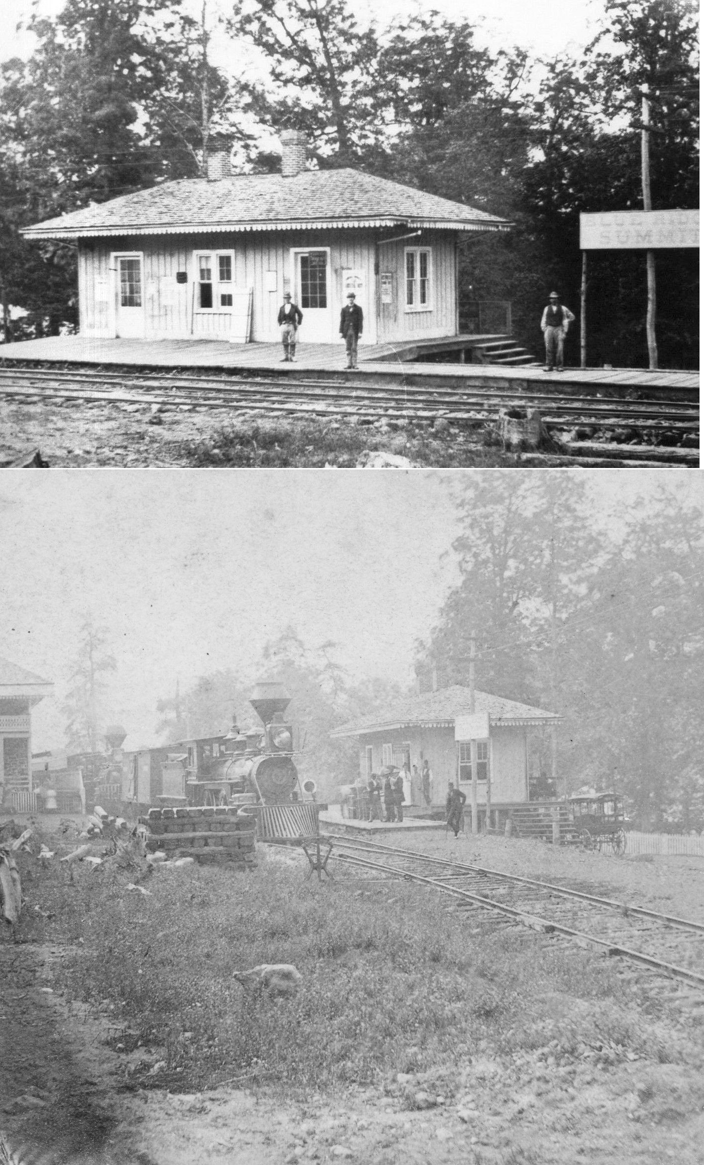
| Blue Ridge Summit |
|
The first station here was built in 1872 and sat on Dutrow Avenue to the west of the existing station. | ||||||
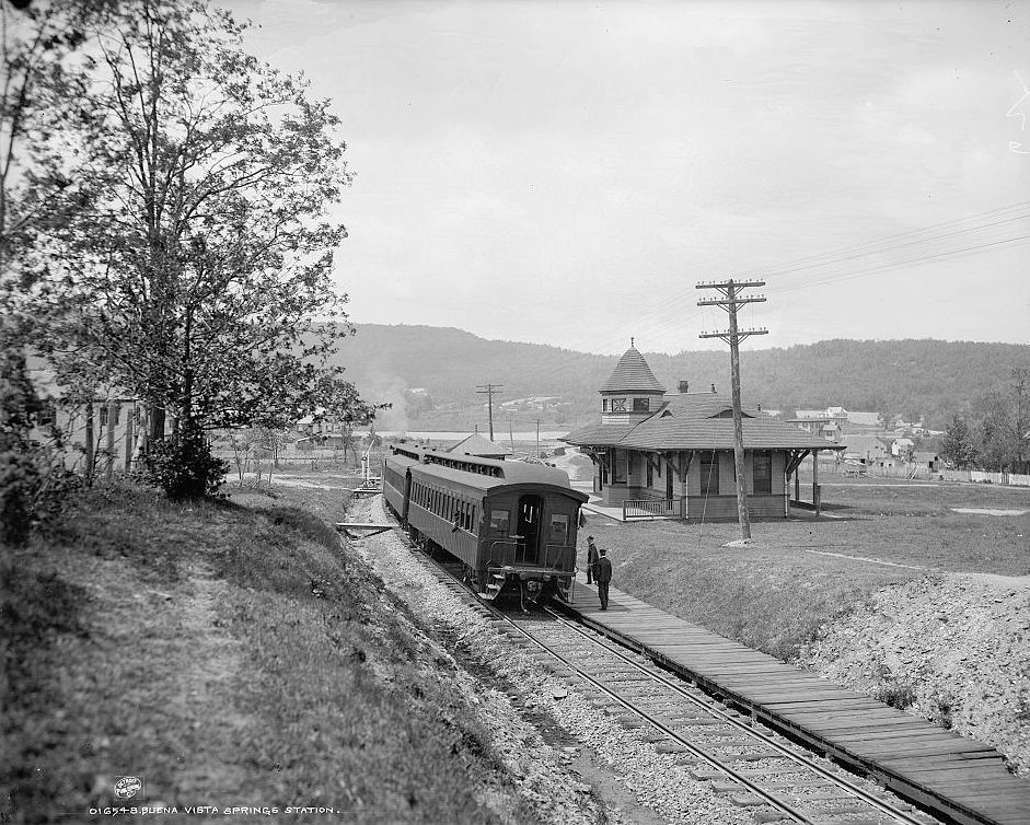
| Buena Vista Springs |
|
This station was near Pen Mar. Can anyone tell me exactly where this station was? Was this at the same site as the Pen Mar Park station (listed below). Update: Thanks to Patrick Trainor, the location of this station has been identified as being in Highfield, Maryland on the north side of Cascade Road at Buena Vista Road at approximately GPS: 39.711136, -77.490272. Even though this station is in Maryland, I decided to keep it on the page here since it's close to PA and it's a great-looking station. | ||||||
| Burgner |
|
|||||||
| Brookside |
|
|||||||
| C&G JUnction (Conococheague) |
|
This station was renamed "C&G Junction" from "Conococheague" in 1892. | ||||||
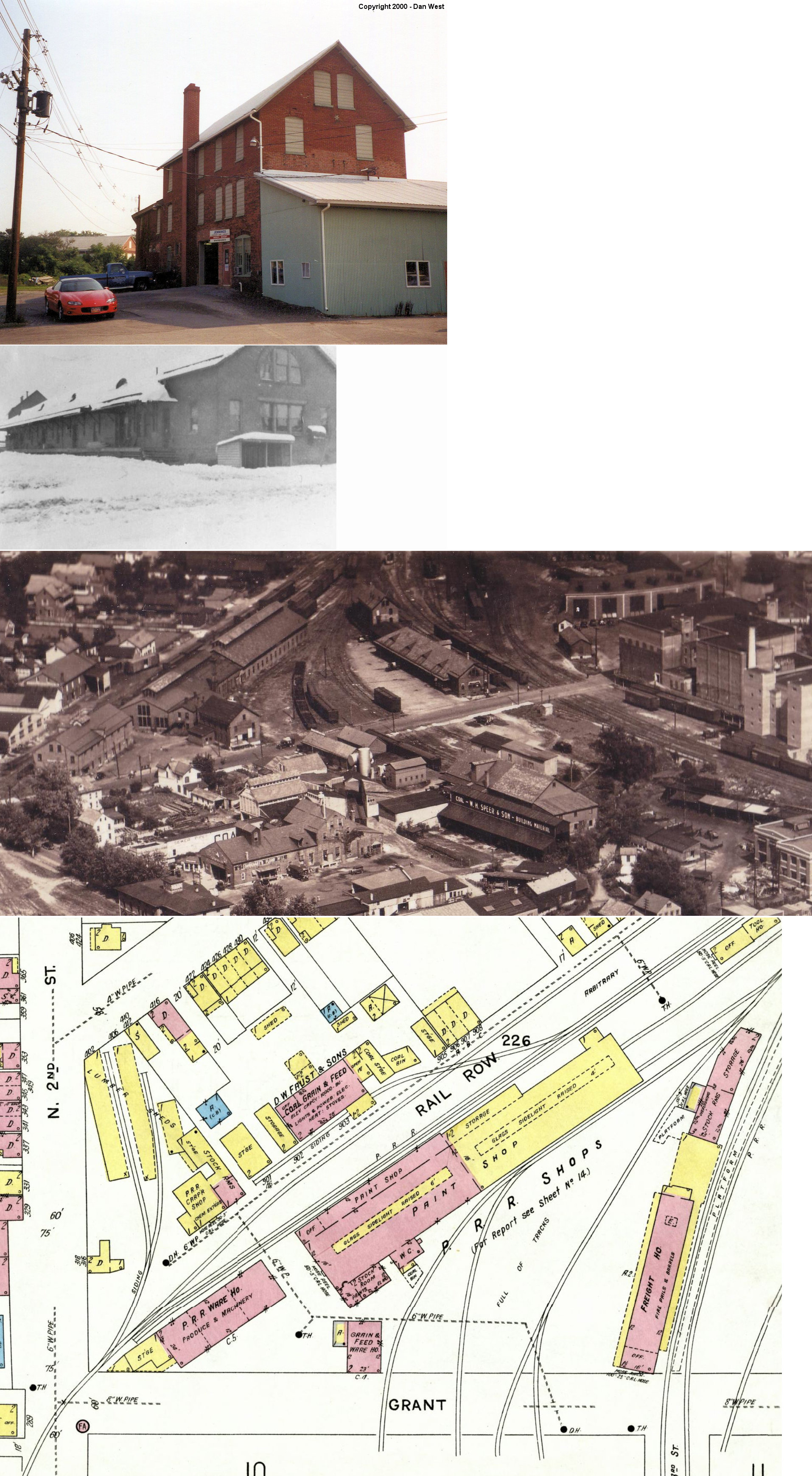
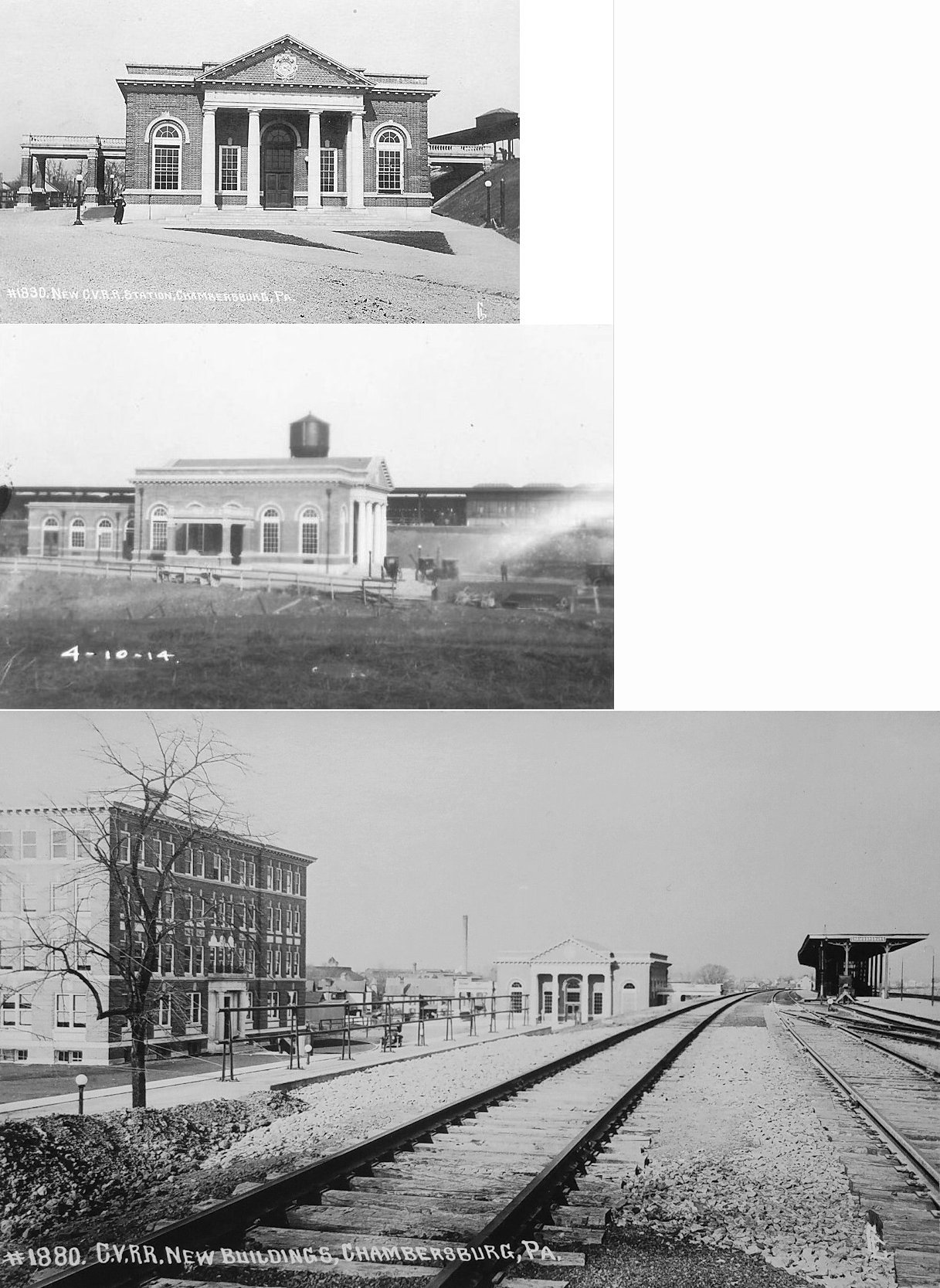
| Chambersburg |
|
An early station here was destroyed along with the RR shops in a Confederate Army raid on October 11, 1862. | ||||||
| Chambersburg |
|
This was the "new" CV station that replaced the one at East 3rd and King Street (still standing) sometime between 1910-1916. It was on the west side of the tracks on what is now Penncraft Avenue between King Street and US 30 at GPS: 39.937486, -77.654683. | ||||||
| Chambersburg |
|
According to the 1868 map, there was a passenger station on the west side of North 2d Street between East King Street and Grant Street (39.940257,-77.658797). This station was opened in 1866. | ||||||
| Chambersburg |
|
According to the 1868 map there was a freight house on the corner of Grant and North 2nd Street at GPS: 39.941530, -77.657957. Sometime between 1887-1894 this freight house was replaced by the one listed below that built to the east. This original freight house, thereafter, was used as a warehouse and appears as such on maps through 1916. It is unknown when it was eventually torn down. | ||||||
| Chambersburg |
|
The second freight house was on the north side of Grant Street between North 2nd and Kennedy Street at GPS: 39.941262, -77.656378. | ||||||
| Chambersburg |
|
This station was on the north side of Lincoln Highway (US-30, formerly East Market Street) on the east side of the tracks beside the creek at GPS: 39.937846, -77.663354. | ||||||
| Chambersburg |
|
There was a freight station on the east side of Hood Street on the west side of the tracks at GPS: 39.938350, -77.663408. | ||||||
| Chambersburg |
 |
There were two buildings here on Lincoln Way that looked like stations, but were replicas. One replica station was at 1233 Lincoln Way (US-30) East (GPS: 39.928420, -77.631390). It was built by Bill Putch, husband of Jean Stapleton. It was supposedly built to the specifications of a real station. As of ealy 2016 it was demolished as the entire lot of buildings that was there was cleared for a new strip mall. The PRR caboose that also sat on that lot has been moved to Norlo Park, the same site of the Quincy Station. | ||||||
| Charmian (Monterey) |
|
This station was located on Charmian Road at approximately GPS: 39.741520, -77.465301. | ||||||
| Cress |
|
This station was on Baer Road in the vicinity of GPS: 39.735835, -77.564157. | ||||||
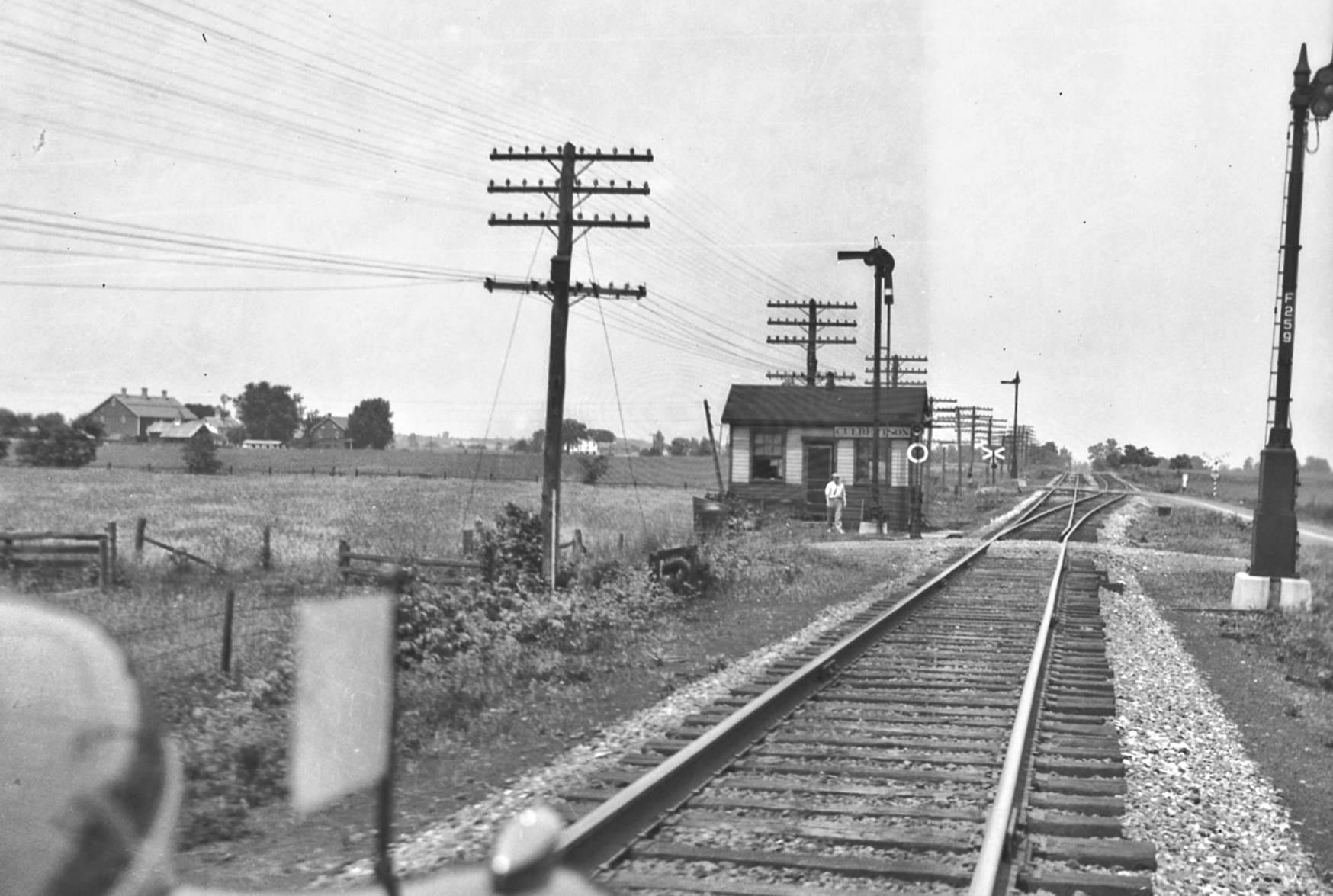
| Culbertson |
|
This station was on the north side of Cumberland highway (PA997) on the east side of the tracks at approximately GPS: 40.000825, -77.622494. | ||||||
Dickey (Parhob) |
|
This station was on the Southern Pennsylvania Branch that ran from Mercersburg Junction north to Richmond Furnace. It is shown on the 1914 county map and was in the vicinity of GPS: 39.865975, -77.895662 on Ft. Loudon Road (PA75). The station is shown as "Parhob" on the 1914 map and as "Dickey" on the 1953 map. | ||||||
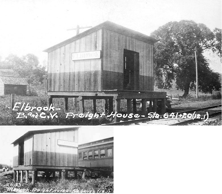
| Elbrook |
|
There was a small freight station here on a raised platform. It was on the north side of Rock Hill Road at approximately GPS: 39.819115, -77.606728. There may have been a passenger shelter here as well. | ||||||
| Fayetteville (East Fayetteville) |
|
This station was on the east side of Mont Alto Road on the north side of the tracks at approximately GPS: 39.900263, -77.555174. This was also known as Fayetteville Station. | ||||||
| Fayetteville (West Fayetteville) |
|
This station was on the south side of US 30 in the vicinity of GPS: 39.916826, -77.575910. | ||||||
| Five Forks (Mt. Hope) |
|
This station was on the south side of Oak Hill Road at approximately GPS: 39.801217, -77.608840. The building that is at this location today may have served another purpose as well as serving as the station. Can anyone confirm or deny this with some record or a photo of the station? | ||||||
| Gap Road |
|
This station was on the Southern Pennsylvania Branch that ran from Mercersburg Junction north to Richmond Furnace. It is shown on the 1914 map on the south side of Dickeys Road in the vicinity of GPS; 39.871761, -77.899720. This station is not shown on the 1953 map. | ||||||
| Geiser |
|
This station was in the general vicinity of South Chruch Street and West 6th Street (GPS: 39.745078,-77.583713). This area is now part of Waynesboro. | ||||||
| Good Siding |
|
|||||||
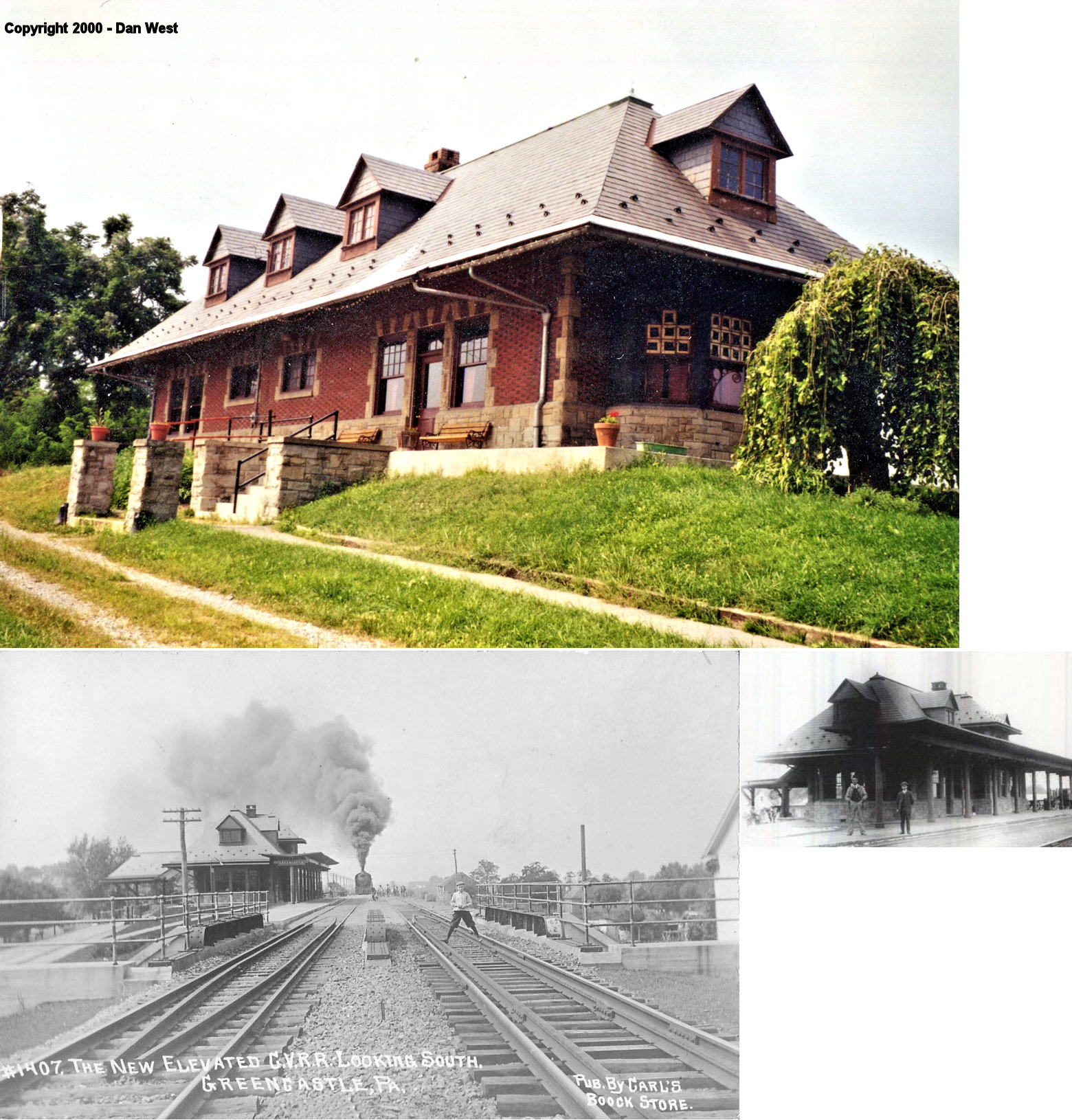
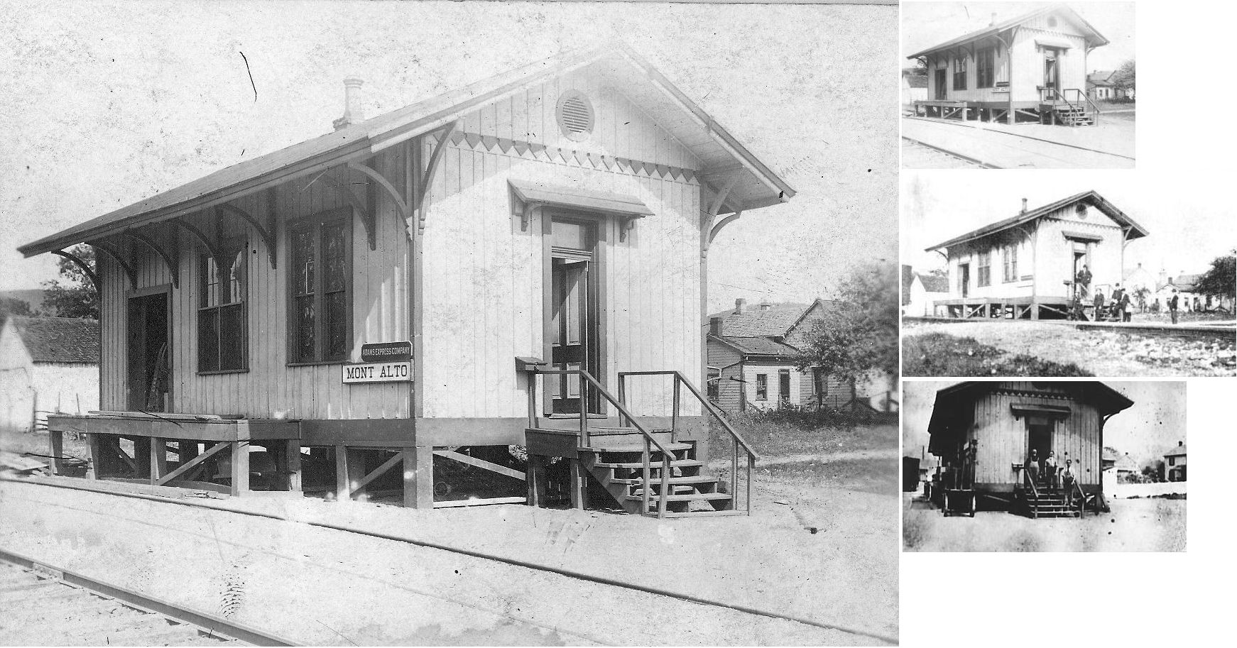
| Greencastle |
|
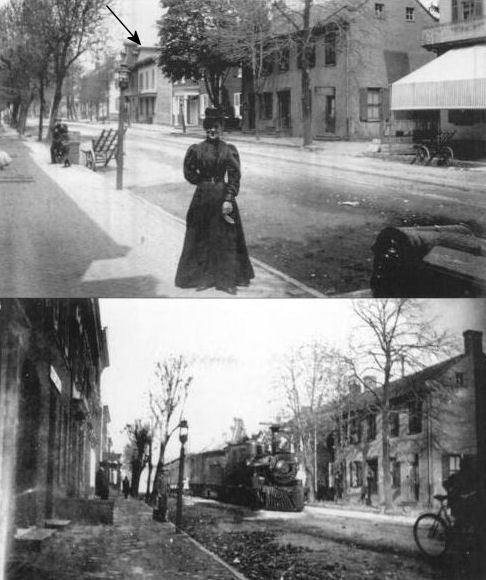
This was the first railroad station in Greencastle. It was at 35 North Carlisle Street (GPS: 39.791174, -77.727118). It later became the Citizen's Bank building when the railroad constructed a new station in 1900. The arrow in the photo indicates the station building. The bottom photo shows at train stopped in front of the station (obscured by the train). | ||||||
| Greencastle |
|
This was the second station built in Greencastle and stood on the NW corner of Carlisle Street and Madison Street at GPS: 39.791872, -77.727104. It was built in 1900. The station also served as temporary classroom space for the high school in 1914 while a new school was being constructed. | ||||||
| Greencastle |
|
According to the 1868 map there was a freight house off South Carlisle Street in the vicinity of where the American Legion is today. | ||||||
| Greencastle Road |
|
This station is shown on the 1914 county map. It was on the west side of US-11 at approximately GPS: 39.845873, -77.711376. The station is not shown on the 1952 map. | ||||||
| Greendale |
|
This station was on the north side of Oak Hill Road on the west side of the tracks at approximately GPS: 39.803327, -77.627236. | ||||||
| Guilford Spring |
|
This station was on the north side of Guilford Spring Road on the west side of the tracks at approximately GPS: 39.897538, -77.674273. | ||||||
| Kauffman's Station |
|
This station, built in 1889, also housed the post office and a grocery store. An older station is shown here on the 1868 map. That station was on the south side of what is now Kauffman Road West on the east side of the tracks. The 1914 map puts the station on the north side of the road on the west side of the tracks (GPS: 39.834598, -77.706623). | ||||||
| Knepper |
|
This station was west of PA997 and south of Stamey Hill Road at approximately GPS: 39.834474, -77.570173. | ||||||
| Ledy (Intersection) |
|
The 1.4 mile Mont Alto Park track split off near here as the RR delivered visitors to the park. It is hard to tell where this station was today as the area has been heavily developed, but I estimate that the station was on the north side of St. Annes Drive at approximately GPS: 39.858145, -77.542818. The station was on the west side of the tracks. | ||||||
| Lurgan |
|
|||||||
| Marion Station |
|
This station was on the south side of Colorado Street in the vicinity of GPS: 39.856959, -77.695220. | ||||||
| Mason & Dixon |
|
This station was on the north side of Mason Dixon Road on the east side of the tracks at approximately GPS: 39.721623, -77.754073. | ||||||
| Mercersburg Junction |
|
This station was on the NW side of Mercersburg Road. Today there is a house with a small building attached that sits next to the old right-of-way that looks like it could have been the station here. Can anyone confirm or deny that this was the station. It is at GPS: 39.857378, -77.889145. Here is a photo. | ||||||
| Midvale |
|
This station was on the west side of Midvale Road in the vicinity of GPS: 39.722802, -77.542819. The mill here also served as an express office. Is the station among the buildings that still stand here at 14443 Midvale Road? It’s not clear that the building still standing here was the station. Some contend it was a feed mill, whereas other claim it was the station. Verification/documentation needed. | ||||||
| Milnor (Long's Station) |
|
This station was on the north side of Milnor Road on the west side of the tracks at approximately GPS: 39.754706, -77.744828. Station was demolished when Norfolk Southern closed Milnor Road for the Intermodal Terminal construct. Its most recent use was as a agricultural warehouse for fertilizer. | ||||||
| Mont Alto |
|
This was the original station. It was originally located on the grounds of the Mont Alto Iron Works and was built in 1872. | ||||||
| Mont Alto Park |
|
Old timetables do not show an actual station at the park itself, but there was a station building or shelter here. | ||||||
| New Franklin |
|
This station was ont he south side of New Franklin Road at approximately GPS: 39.881107, -77.632095. | ||||||
| Nunnery |
|
Both Orphanage and Nunnery are listed as stations on the old Mont Alto time tables. It is not clear if they had actual depots or shelters. The Nunnery was at milepost 16.2 (from Waynesboro Jct. with the Cumberland Valley RR), and the Orphanage was at mile 15.2. The Nunnery station was on the north side of Nunnery Road on the east side of the tracks at approximately GPS: 39.789721, -77.576952. | ||||||
| Orphanage |
|
This station was on Orphanage Road in the vicinity of GPS: 39.803708, -77.575890. It may have been a shelter rather than a station building. | ||||||
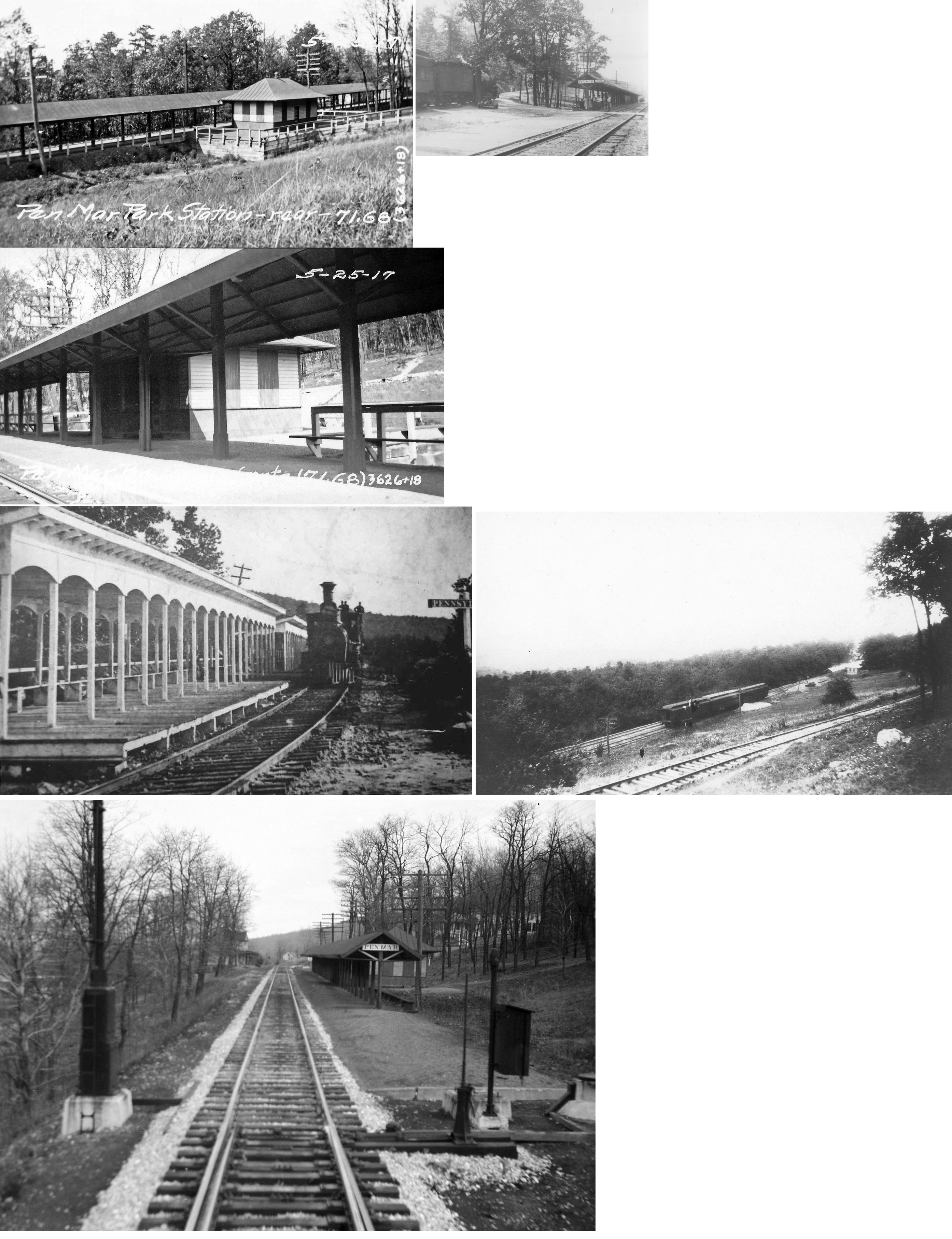
|
Pen Mar Park |
|
|||||||
| Pinola |
|
|||||||
| Pond Bank |
|
This station was near the corner of White Rock Road and Railroad Street in the vicinity of GPS: 39.872538, -77.540514. | ||||||
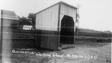
| Quinsonia (Conboy) |
|
This shelter-type station was on the NE side of PA316 at approximately GPS: 39.833140, -77.605322. | ||||||
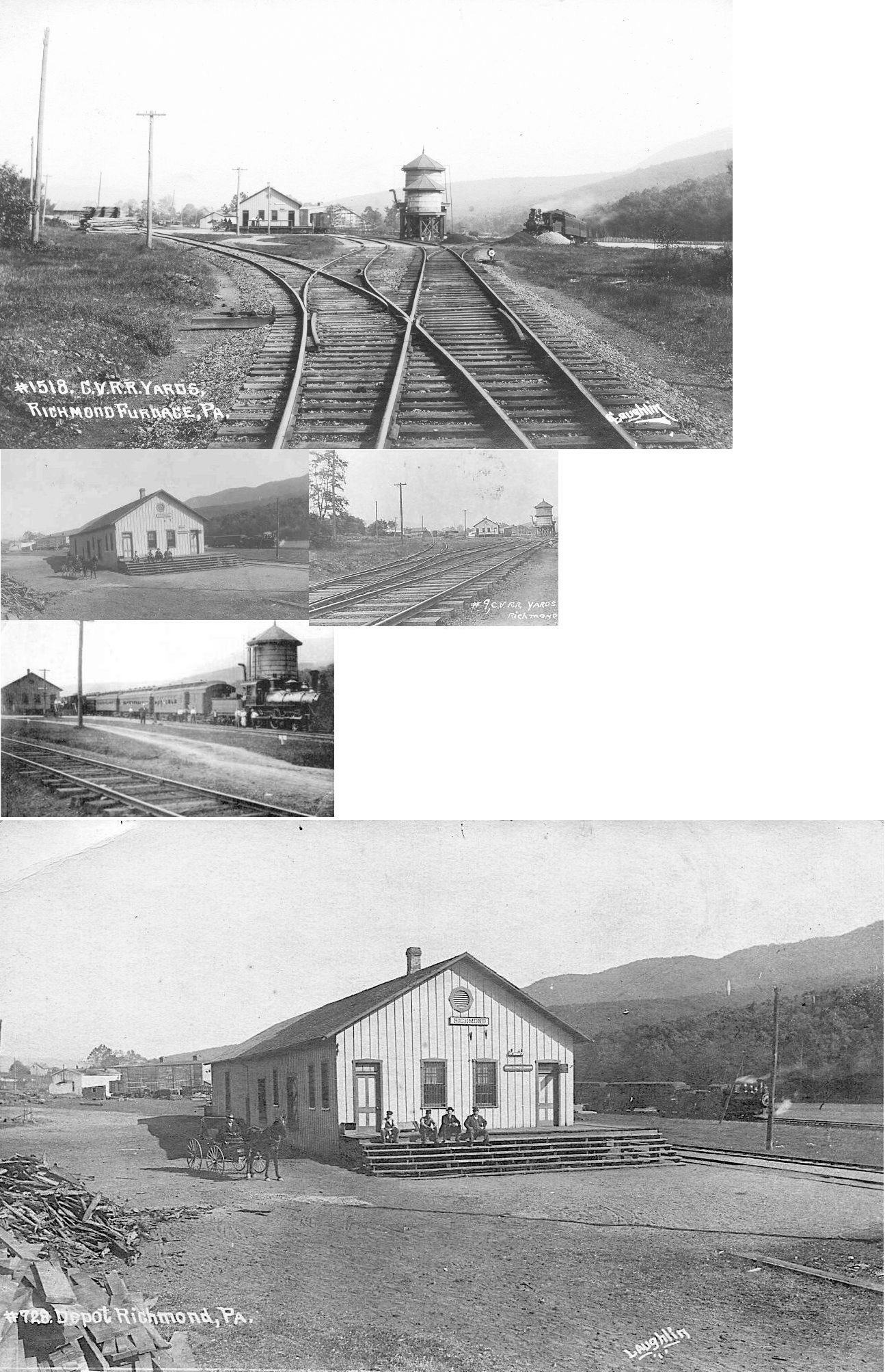
| Richmond Furnace |
|
|||||||
| Rockdale |
|
This station was on the west side of Rockdale Road at approximately GPS: 39.859909, -77.813407. It is shown on the 1914 and county 1953 maps. | ||||||
| Ryder |
|
This station is shown on the 1953 county map. This station was on the Southern Pennsylvania Branch that ran from Mercersburg Junction north to Richmond Furnace. | ||||||
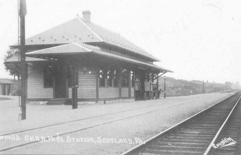
| Scotland |
|
Passenger station. | ||||||
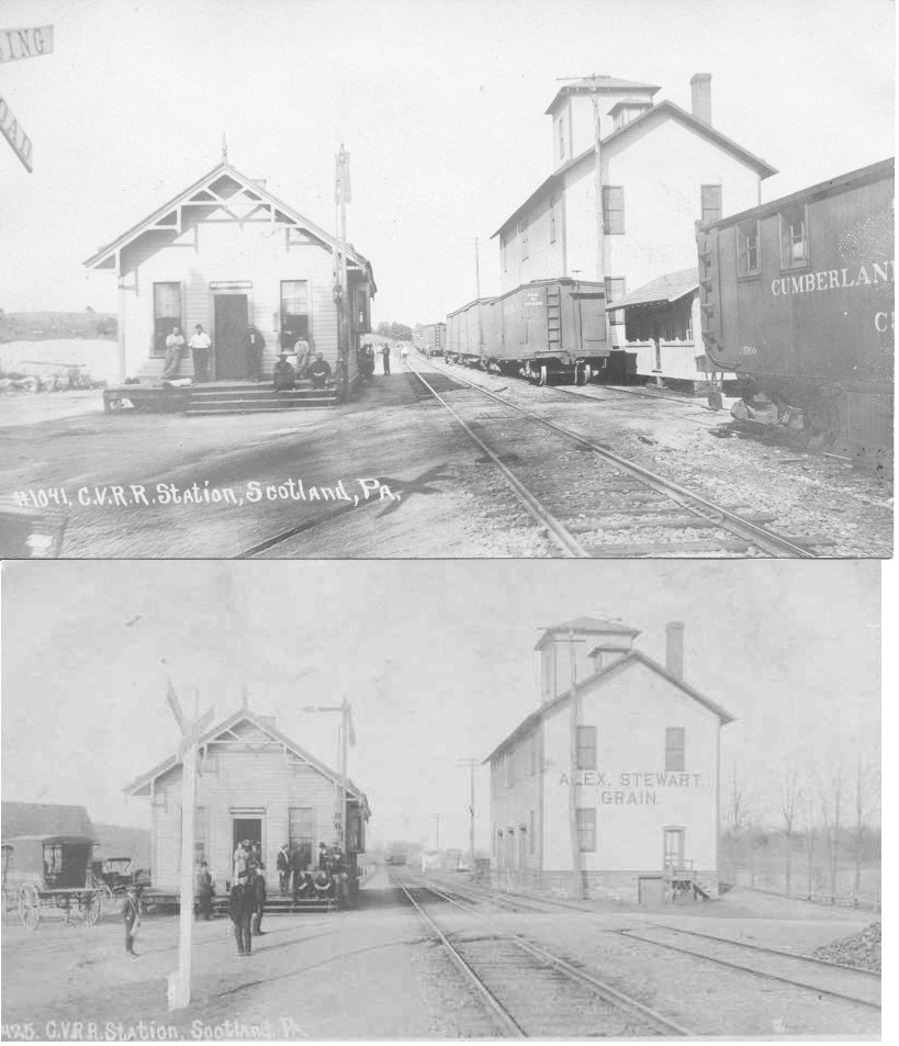
| Scotland |
|
This was probably the original station, later used as a freight station. | ||||||
| Stone Bridge Station |
|
This station was on Stone Bridge Road in the vicinity of GPS: 39.851509, -77.757405. The 1914 PA State Highway Map puts the station on the east side of the road, whereas the 1951 map puts the station on the west side of the road. These maps, however, tend to not be too precise with the station locations. | ||||||
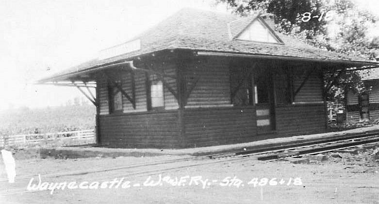
| Waynecastle |
|
Passenger station. W&F = Washington & Franklin Railway. | ||||||
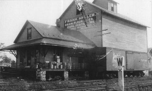
| Waynecastle |
|
Although this freight station was probably built by the mill rather than the railroad, since it was attached to the mill, it is a classic railroad structure. It was located at 3289 Waynecastle Road in the vicinity of GPS: 39.772110, -77.650503. | ||||||
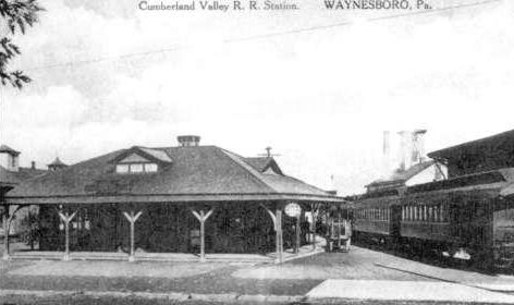
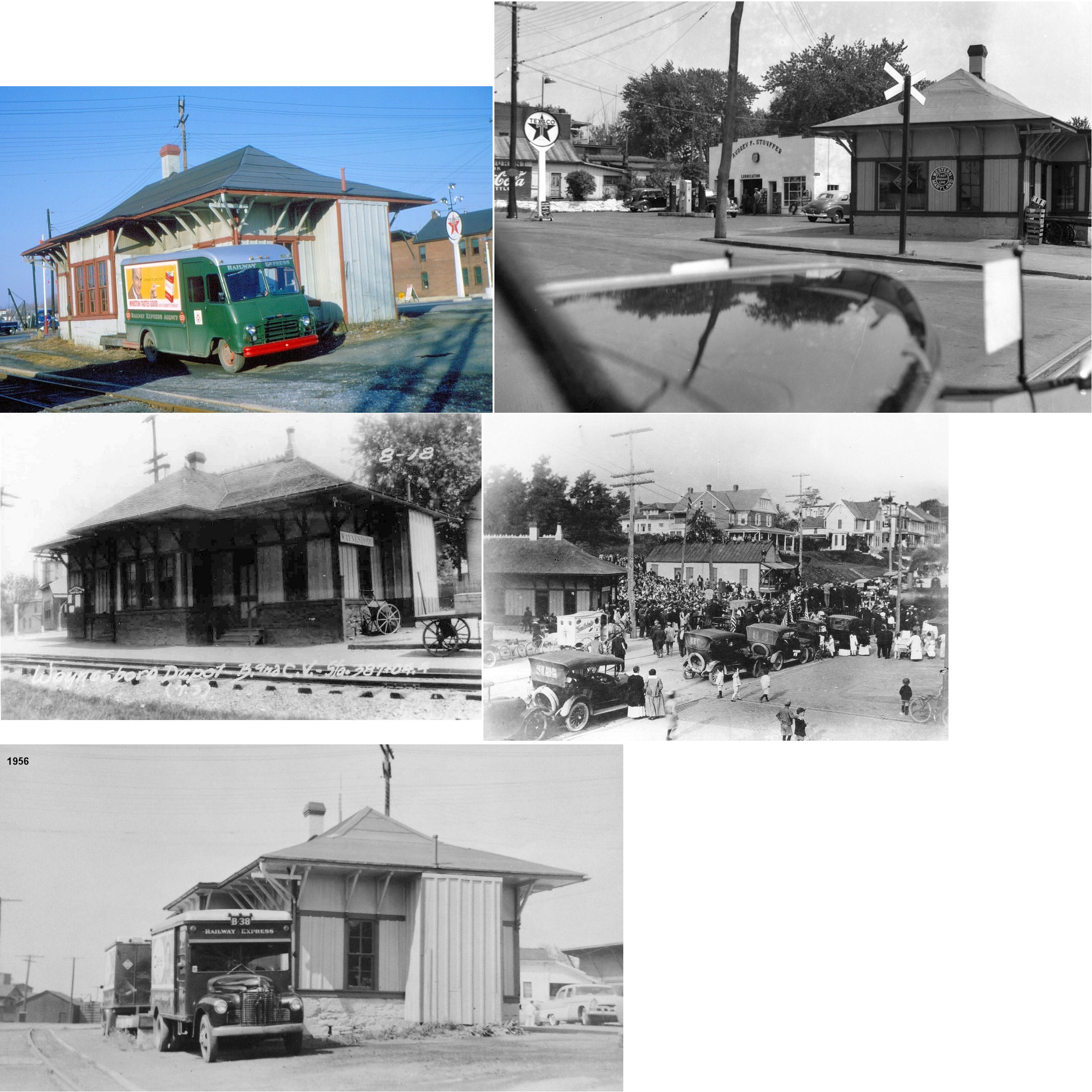
| Waynesboro |
|
The passenger station was on the north side of Main Street at GPS: 39.759459, -77.584844. It was built between 1891-1896. | ||||||
| Waynesboro |
|
The original frame freight house/grain warehouse here was along what is now Cumberland Valley Avenue on the east side of the tracks at GPS: 39.759969, -77.584159. The building remained for some time as a feed and grain warehouse under private ownership after the CVRR built its new freight station (listed below). | ||||||
| Waynesboro |
|
A new brick frieght station was constructed between 1902-1910 just to the south of the old freight station at corner of West Main Street and Cumberland Valley Avenue at GPS: 39.759178, -77.584365. | ||||||
| Waynesboro |
|
A.K.A. the Baltimore & Cumberland Valley RR on this line. The passenger station was on the south side of Main Street at GPS:39.759080, -77.584997. | ||||||
| Waynesboro |
|
The original frame freight house/grain warehouse here was on the west side of the tracks at approximately GPS: 39.760063, -77.585124 about 150 feet north of Main Street. The building remained for some time as a feed and grain warehouse under private ownership after the WM its new freight station (listed below). | ||||||
| Waynesboro |
|
The WM built a new brick freight house closer to Main Street on a new siding sometime between 1896-1902. It was located at approximately GPS: 39.759644, -77.585492. | ||||||
| Waynesboro |
|
There were three small freight houses on Chruch Street southwest of East 5th Street where the WM and CV crossed. Two were on the NW side and one was on the SE side. | ||||||
| Waynesboro Junction |
|
This was at the junction of the Mont Alto RR and the Cumberland Valley RR NW of Grand Point Road. It is shown as Mont Alto Junction on the map below. The station was in the vicinity of GPS: 39.964082, -77.605947. | ||||||
| Wingerton |
|
This station was on the north side of State Line Road on the west side of the tracks at approximately GPS: 39.730929, -77.671325. | ||||||
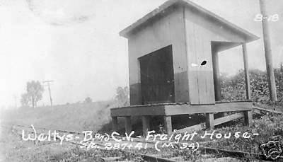
| Welty |
|
|||||||
| Woodstock |
|
This station was on the NW side of Edgewood Road on the east side of the tracks at approximately GPS: 39.939969, -77.586350. | ||||||
| 1895 FRANKLIN COUNTY RAILROAD MAP | ||||||||
 |
||||||||
| Notes About Existing
Stations... Chambersburg (CV Freight) - This was the office section of the 2nd generation CV freight house that was here. Fire destroyed south 2/3 of structure in the early 1990s. Greencastle (PRR) - This was known as the Greencastle "highline" station. Greencastle (CV Freight) - This building is shown as the CV freighthouse on later Sanborn maps and a freight house appears here as early as 1868 on the county atlas. Mercersburg (CV) - The larger SW section of this building was the original passenger station which dates from prior to 1885. When a freight station was needed, the NE third of this building was added on to serve as the passenger section and the SW section became the freight station. This happened sometime between 1891 and 1896. Mont Alto (Mont Alto RR) - This station most recently served as a teen center and polling place. It now (as of 2009) is vacant. Quincy (Mont Alto RR) - This station has been moved at least three times and is in good condition. Station was bought by Bill Putch, Producing Director of Totem Pole Playhouse and husband of actress Jean Stapleton, and moved to his Caledonia Station Restaurant on US 30 in 1982. Purchased by James Fouchard in 1987 and later moved to another site on US 30. Acquired by Guilford Township in 2008. Moved to Norlo Park and restored to Cumberland Valley/PRR color scheme from information provided by Mr. Fouchard. Now serves as a museum. For more information and photos see James Fouchard's Quincy Station website. |
||||||||