|
|
||||||||
| EXISTING STATIONS | ||||||||
|---|---|---|---|---|---|---|---|---|
| Station Name |
Original Railroad |
Current Location |
Type | Current Use |
Date Built |
Track Status |
Building Material |
More Info |
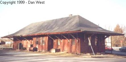
| Belle Vernon |  |
99 First Street (GPS: 40.127598, -79.874816) |
P | Residence | ???? | In Use | Brick | |
| Brownsville |
 |
53 Market Street (North side of Market Street between Brown Street and
Brownsville Avenue) (GPS: 40.022619, -79.886161) |
P | Businesses | 1928 | In Use | Brick |
|
| Brownsville |
|
Market Street (North side of Market Street between Brown Street and
Brownsville Avenue) (GPS: 40.022967, -79.885629) |
F | Vacant | 1928 | In Use | Brick | |
| Brownsville |
 |
NW side of Albany Road just NE of U.S. 40 overpass. (GPS: 40.024234, -79.883050) |
F | Vacant | 1931 | In Use | Brick | |
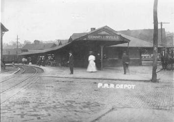
| Connellsville (New Haven) |
AND  |
900 West Crawford Street (GPS: 40.016866, -79.599083) |
P | Business | 1911 | Gone | Brick | |
| Connellsville (New Haven) |
AND |
US 119 & PA 711 (GPS: 40.016653, -79.600992) |
C | Storage | 1907 | Gone | Wood |
|
| Connellsville |
 |
North Water Street just north of West Peach Street. (GPS: 40.019988,-79.592707) |
P | Railroad | 2011 | In Use | Brick | |
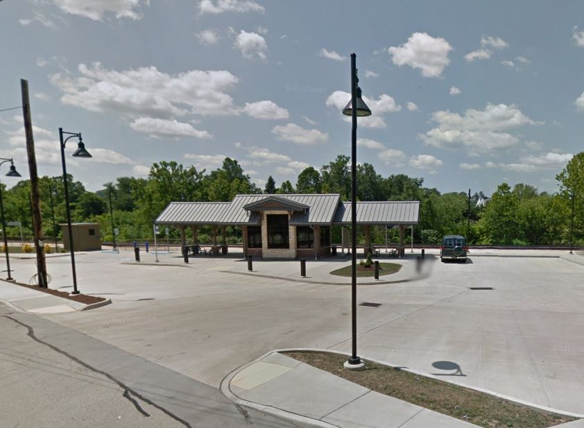
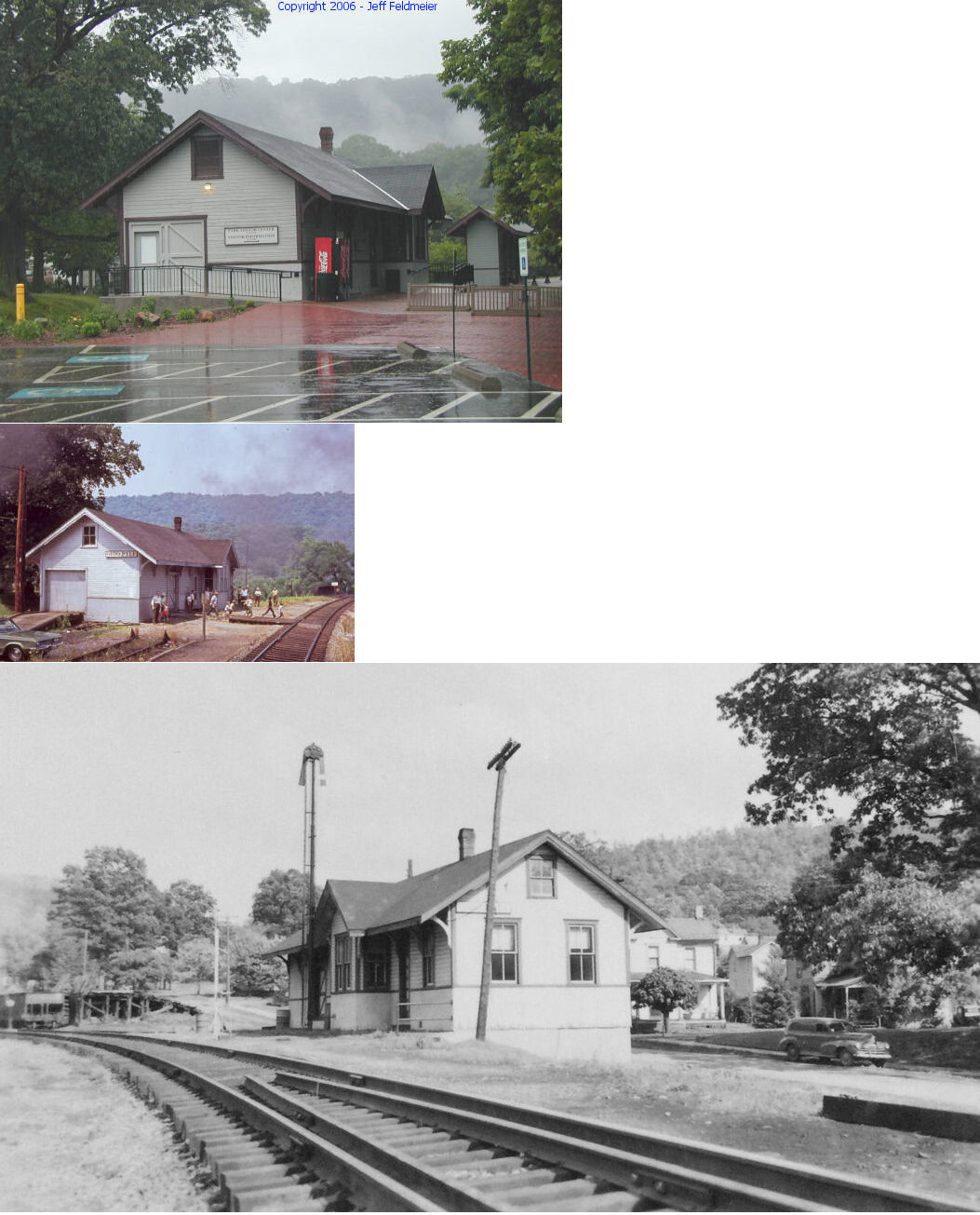
| Ohiopyle | |
Main & Sheridan Streets (GPS: 39.869846, -79.492170) |
C | Civic | ???? | Aband. | Wood |
|
| Uniontown |  |
PA51 north of West Penn Street (GPS: 39.902892, -79.726577) |
F | Shops | ???? | In Use | Brick | |
| STATIONS OF THE PAST | ||||||||
| Station Name |
Original Railroad |
Notes | ||||||
| Ache Junction |
|
The Mon Railway junctioned with the PRR Coal Lick Run Branch here. It's unclear if there were two stations here or a shared station. | ||||||
| Ache Junction |
|
A station is listed here on the 1923 PRR list of stations and sidings. This was at the end of the Coal Lick Run Branch. | ||||||
| Adah |
|
|||||||
| Adelaide |  |
|||||||
| Adelaide | |
|||||||
| Alicia |
|
|||||||
| Allison |
|
This station, likely a flagstop, was on the Dunlaps Creek Division. | ||||||
| Antram |
|
|||||||
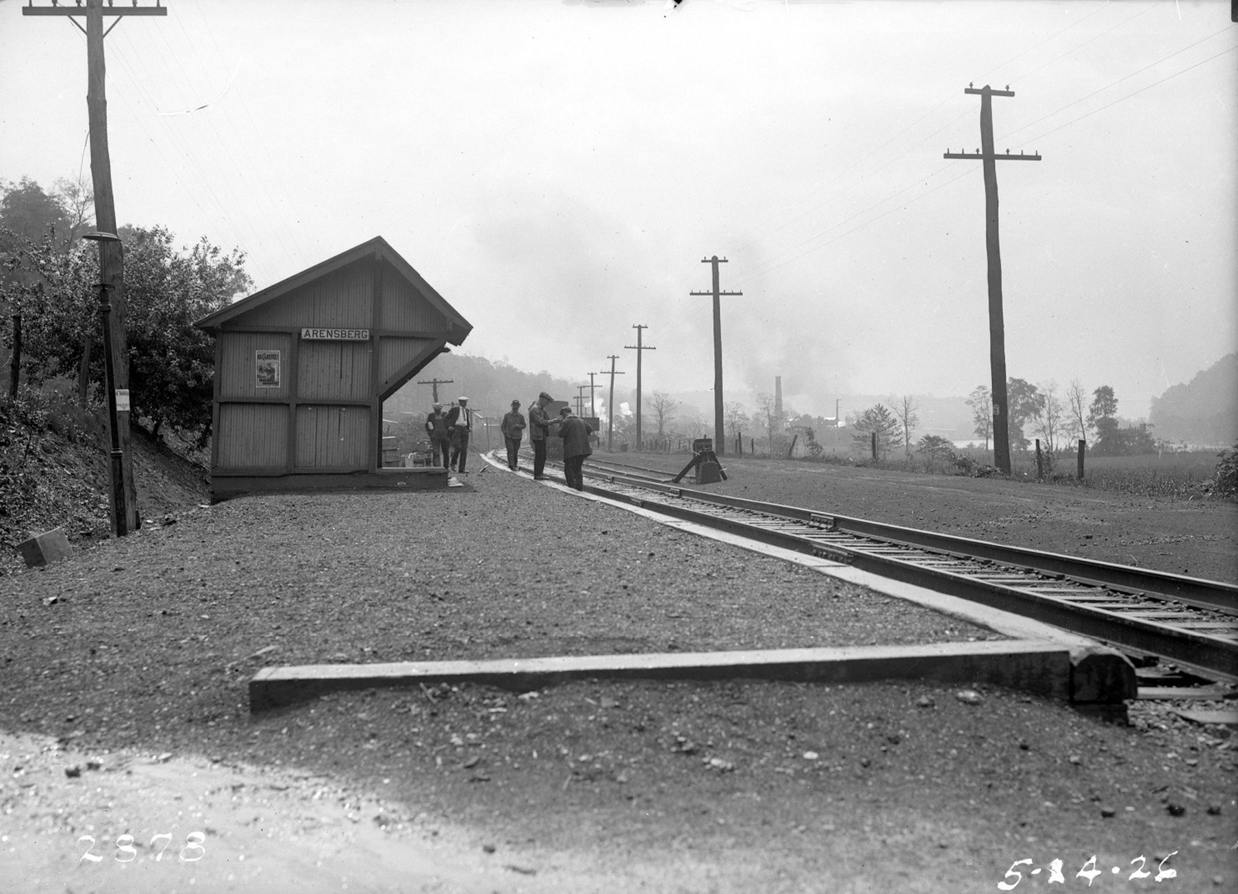
| Arensburg |
|
|||||||
| Arnold City | |
This was on the P&LE's Downer Junction Branch. | ||||||
| Atchison | |
|||||||
| Bannings Station | |
This station was off Railroad Street NW of Banning Road. There was a Pittsbuirgh & Connellsville station here as early as 1872 as it is shown on the county map from that year (GPS: 40.120234,-79.752103). | ||||||
| Belbois | |
This was on the PRR's Grindstone Branch. | ||||||
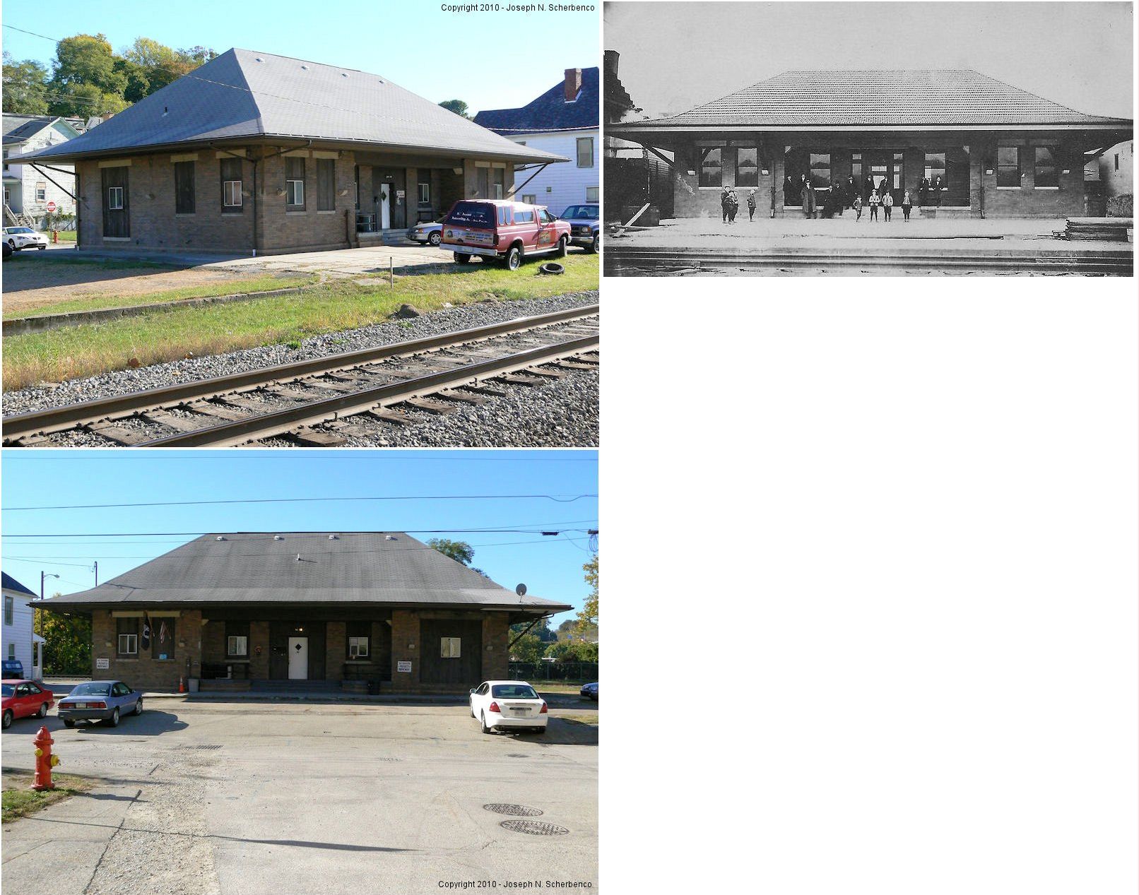
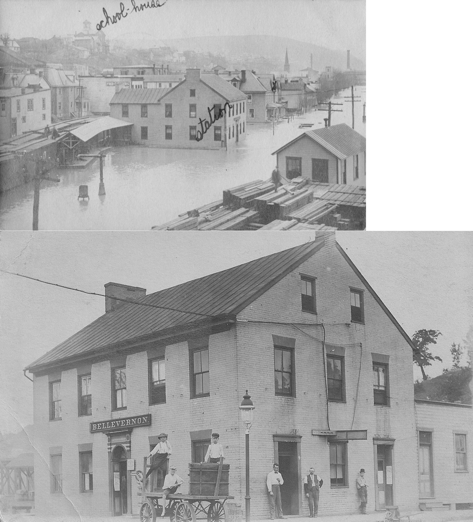
| Belle Vernon |
 |
The first station here was near the corner of Water and First Streets in the lot adjacent to the existing station at GPS: 40.127681, -79.875064. This old station is shown on the Sanborn maps from 1895-1910. On the 1900 map, it is labeled as the Erie Hotel as that was the building's original purpose and may have served both as a hotel and station for some time. The photo shows it as the station during a flood in 1907. The new station was built sometime between 1910-1918. | ||||||
| Belle Vernon |
|
There was a freight station on a short two-track spur just to the NW of the passenger station at GPS: 40.127840, -79.875254. | ||||||
| Bidwell | |
|||||||
| Big Meadow Run |
|
|||||||
| Bitner | |
This station was between the northern terminus of the Vance Mill Branch and the Bute Run Branch. | ||||||
| Braznell | |
This was on the Redstone Branch. | ||||||
| Brier Hill |
|
|||||||
| Broadford | |
|||||||
| Broadford | |
This station was on the P&LE's Youghiogheny Northern Branch. | ||||||
| Broadford Junction | |
This was the start of the Youghiogheny Branch. | ||||||
| Brown | |
This was on the P&LE's Downer Junction Branch between Arnold City and Perryopolis Junction. | ||||||
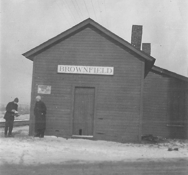
| Brownfield | AND |
The B&O and PRR may have shared this station on the north side of Brownfield Road at approximately GPS: 39.859443, -79.716571. It was built by the PRR in 1895. | ||||||
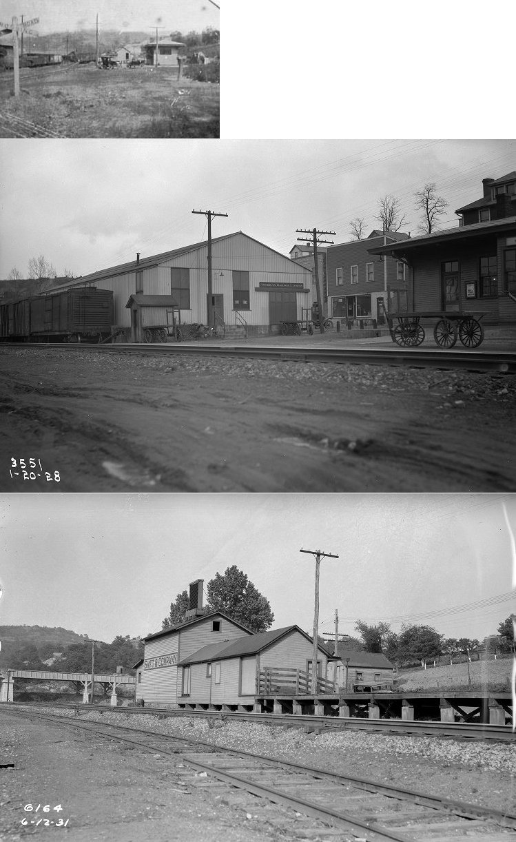
| Brownsville |
|
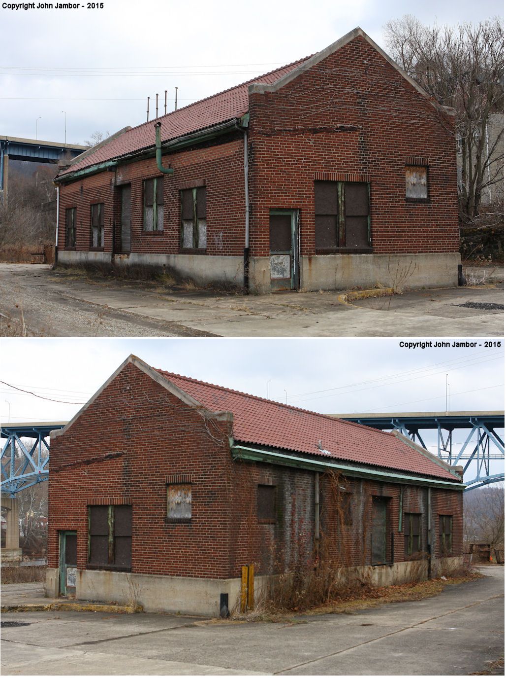
Before the brick freight house was built in 1931, there was a frame freight station on the NW side of Market Street between Brown Street and Albany Road at GPS: 40.022895, -79.885378. | ||||||
| Brownsville Junction | |
|||||||
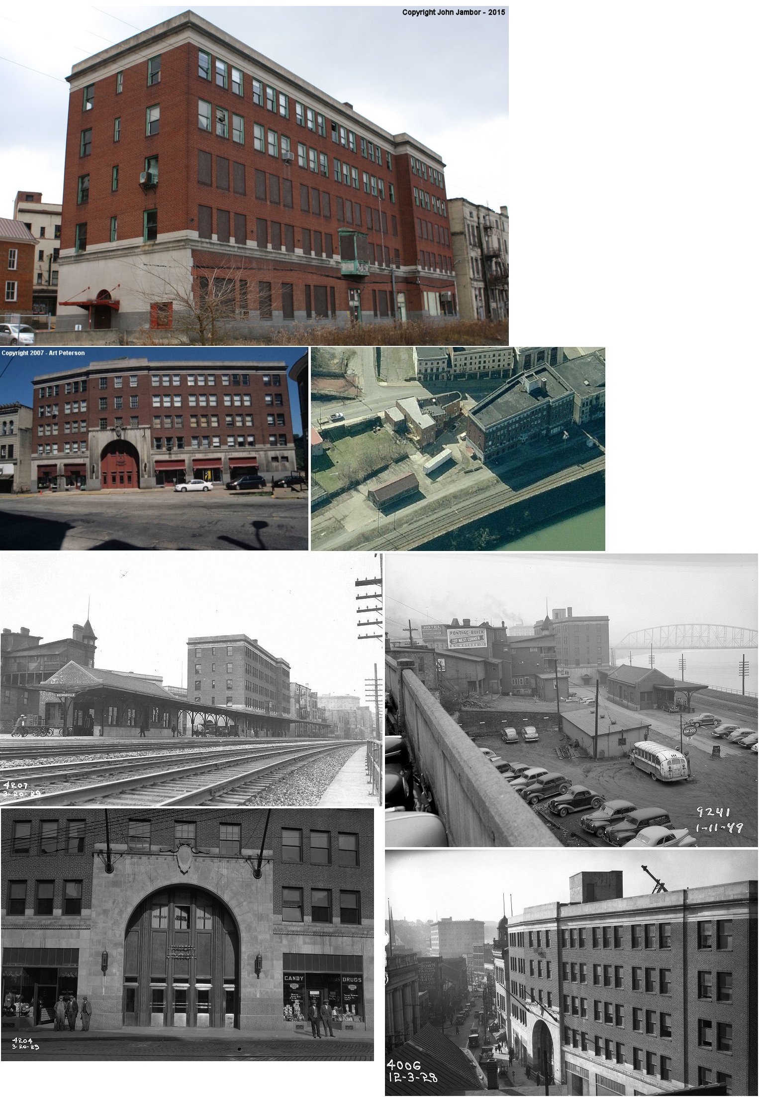
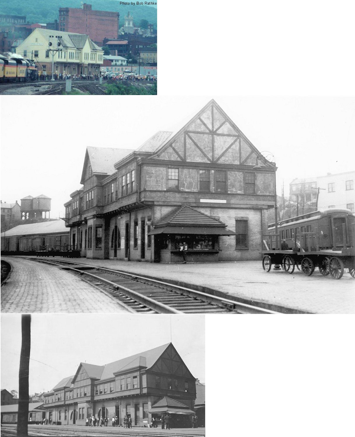
| Brownsville |
|
This was the first union station. It was replaced by a new building in the same location in 1928. | ||||||
| Brownsville |
|
This white metal building was used as a temporary station to transition from the old union station to the new union station in 1928. This first photo shows the temporary station with the old union station being demolished in the background. The second photo shows the temporary station with the new union station being built in the foreground. | ||||||
| Brownsville (South Brownsville) |
|
A MRY station is listed here in 1923 PRR List of Stations & Sidings. | ||||||
| Bute | |
This was on the Vance Mill Branch. | ||||||
| Casparis | |
|||||||
| Charlestown Station |
|
|||||||
| Cheat River | |
|||||||
| Clarissa | |
This was on the P&LE's Dickerson Run Branch. | ||||||
| Coffman | Indian Creek Valley RR |
The ICVRR was built in 1908-1910. It was acquired by the B&O in 1927, abandoned 1965 Jones Mill to Roaring Run, and abandoned 1972 Roaring Run to Indian Creek Jct. | ||||||
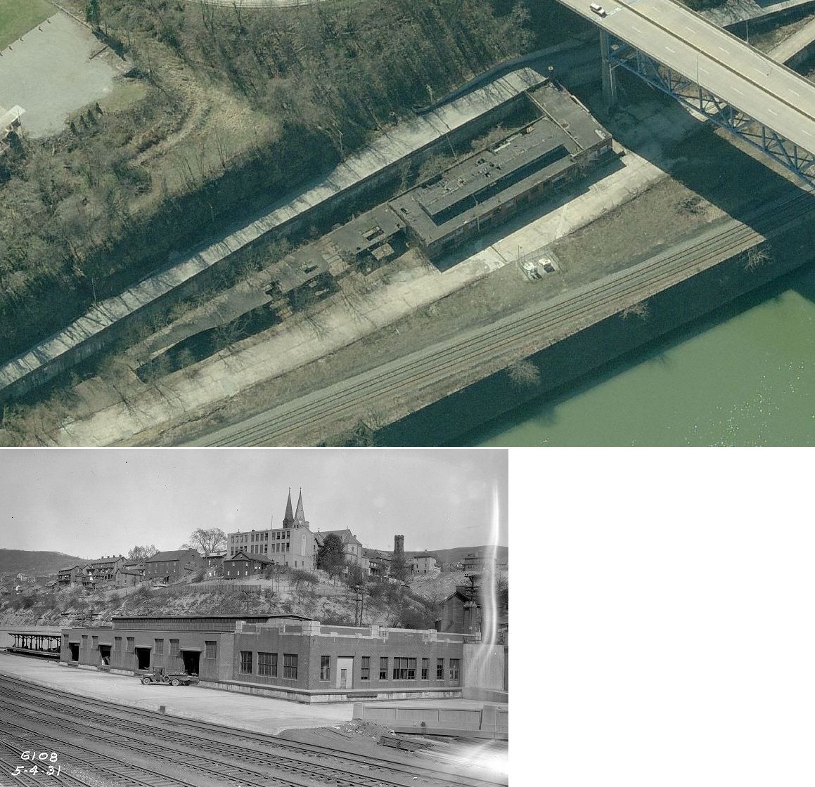
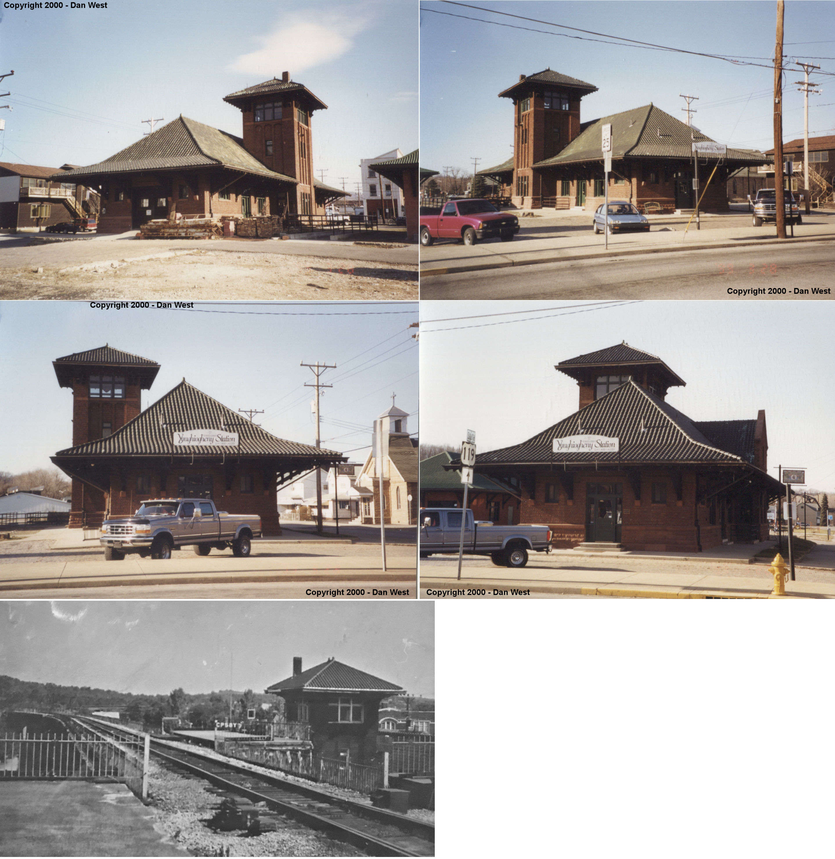
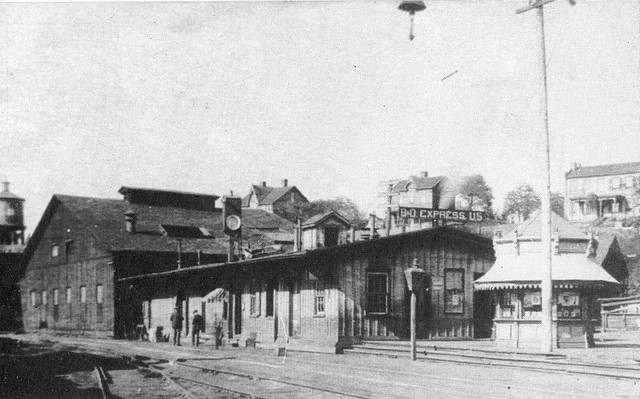
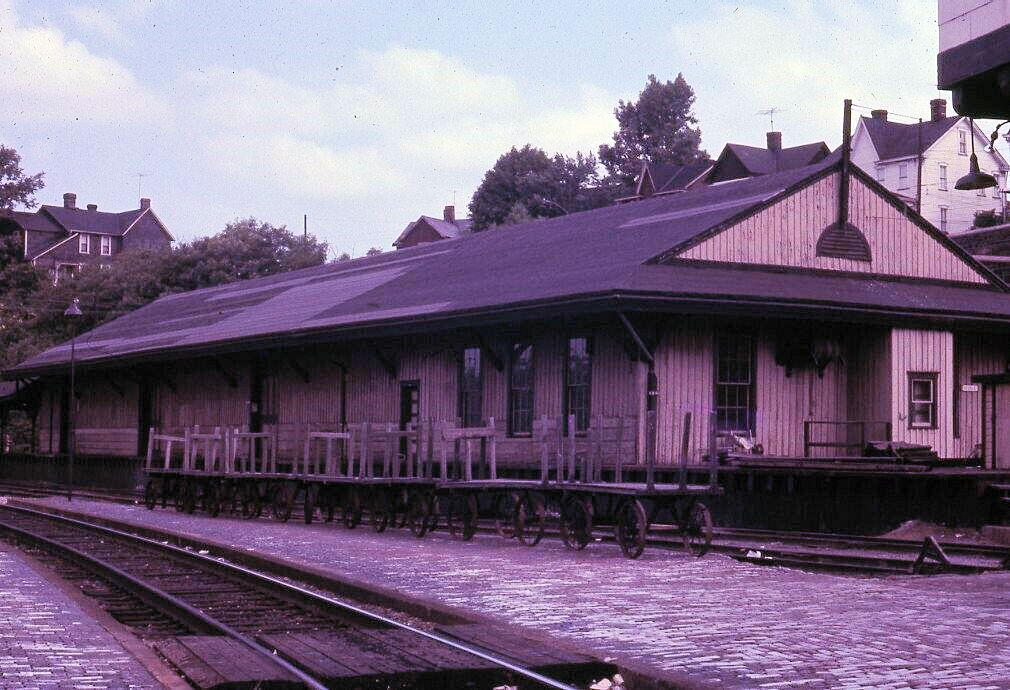
| Connellsville | |
The first station here was built by the Pittsburgh & Connellsville RR on the west side of Water Street on the east side of the tracks north of Peach Street (just north of where the Amtrak station is today) (GPS: 40.020142,-79.592801). This station is shown on the county map from 1872. The station was attached to the engine boiler shop at the engine facilities here. | ||||||
| Connellsville | |
The second station here was built in the same location as the first station (GPS: 40.020142,-79.592801). It was built sometime between 1897-1901. | ||||||
| Connellsville | |
The freight station here was just to the NW of the passenger station at GPS: 40.020741, -79.593335. It was built sometime between 1897-1901. | ||||||
| Connellsville | |
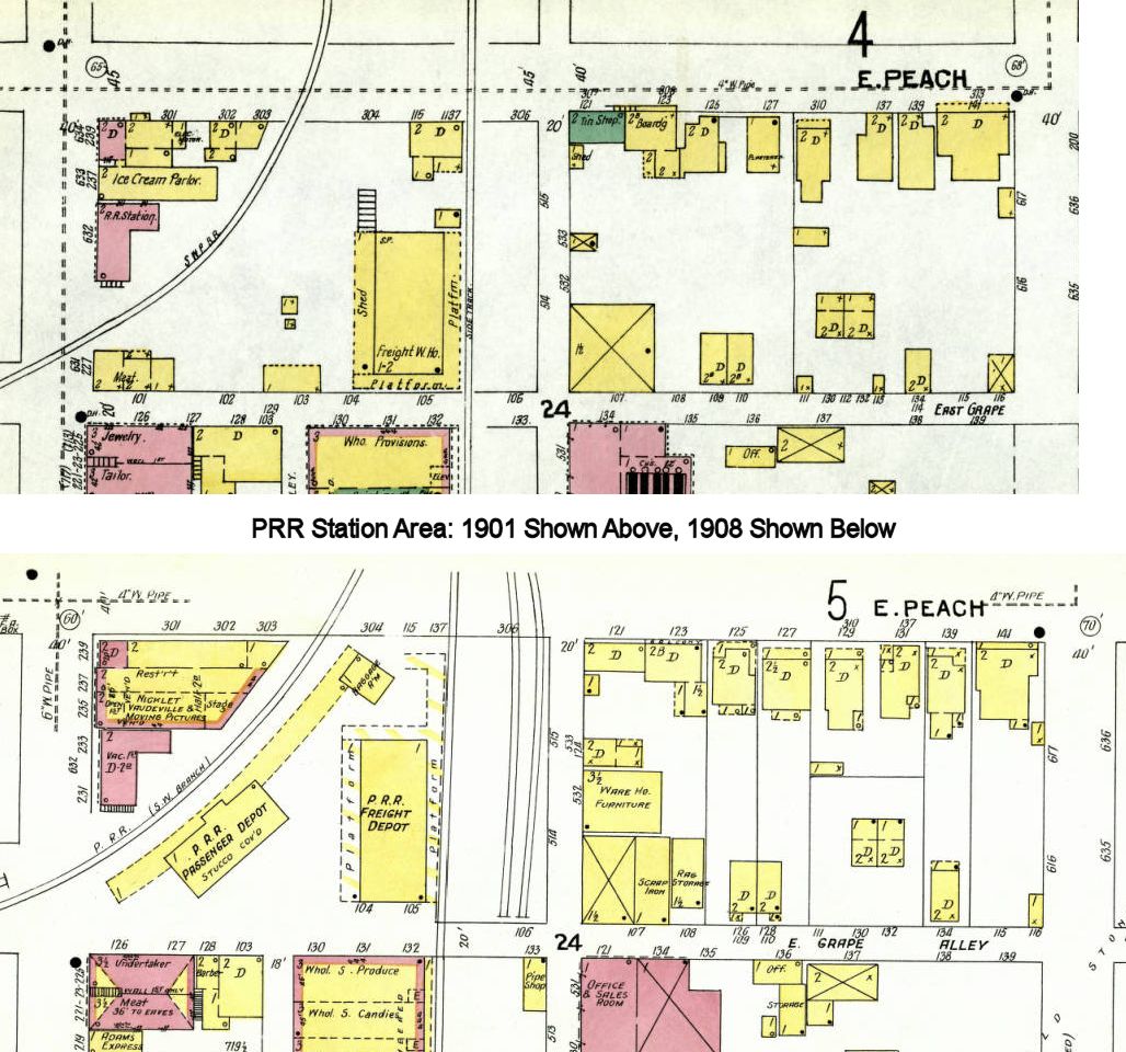
In 1886, the South-West Pennsylvania RR passenger station was on the east side of Pittsburgh Street between Peach Street and Grape Alley (GPS: 40.019694, -79.588960). A new station was constructed across the tracks between 1901-1907. This original station building survived until at least 1914 when it was used as an Adams Express office. See this map for a comparison of that area in 1901 and 1908. | ||||||
| Connellsville | |
There was an early Southwestern PA RR freight house on the south side of Peach Street bewteen Carnegie Street and Pittsburgh Street (GPS: 40.019575, -79.588892). This station is shown on the 1886 map and later maps. | ||||||
| Connellsville | |
In 1903 a new, larger station was built in the block bordered by Pittsburgh Street, Peach Street and Grape Alley. The old station remained across the tracks vacant with a dwelling on the second floor. See this map for a comparison of that area in 1901 and 1908. | ||||||
| Connellsville |
|
There was a 1970s-era metal station here before the new station was built in 2011. | ||||||
| Connellsville (New Haven) |
|
The New Haven Southwestern PA RR station was on the north side of Crawford Street (formerly Ferry Street) at 4th Street (GPS: 40.017222, -79.596601). There was a small freight station to the NE on the tracks that ran along 5th Street (GPS: 40.017383, -79.597179). The freight station later saw the addition of a larger platform (as shown on the 1908 map). | ||||||
| Connellsville (New Haven) |
|
There was a small freight station to the NE of the passenger station on the tracks that ran along 5th Street (GPS: 40.017383, -79.597179). The freight station later saw the addition of a larger platform (as shown on the 1908 map). | ||||||
| Connellsville (New Haven) |
|
The first station here on this line was at approximately the same spot as the 1907 station. This original station is shown on the 1896 and 1901 maps. | ||||||
| Crossland | |
|||||||
| Darent | |
This station is listed on the 1923 PRR List of Stations & Sidings on the Southwest Branch. | ||||||
| Darnley | |
This station was between Dickerson Run and Sand Rock. | ||||||
| Davistown | Indian Creek Valley RR |
|||||||
| Dawson | |
The station was on the north side of the tracks between Cochran Street and Main Street at GPS: 40.045704, -79.654597. | ||||||
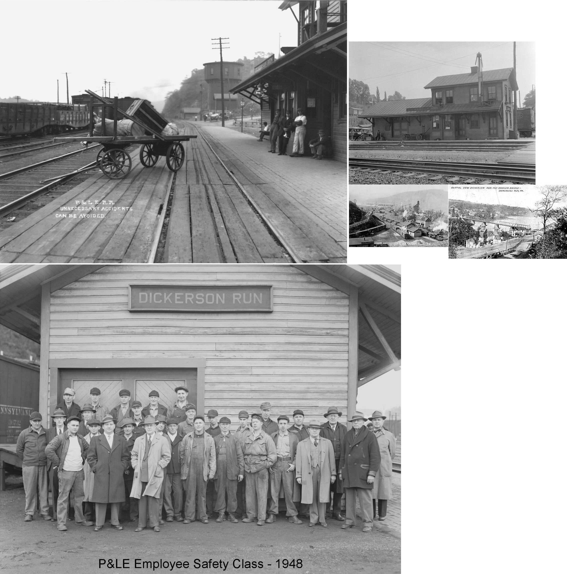
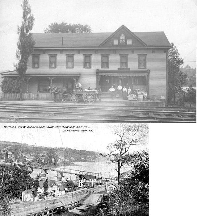
| Dickerson Run | |
This original Pittsburgh, McKessport & Youghiogheny station was built in 1883. | ||||||
| Dickerson Run | |
Dickerson Run was the excahnge point between the P&LE and WM. The P&LE (PMcK&Y) station is pictured above and this may have served as the WM station as it sat across the tracks. | ||||||
| Downer Junction | |
|||||||
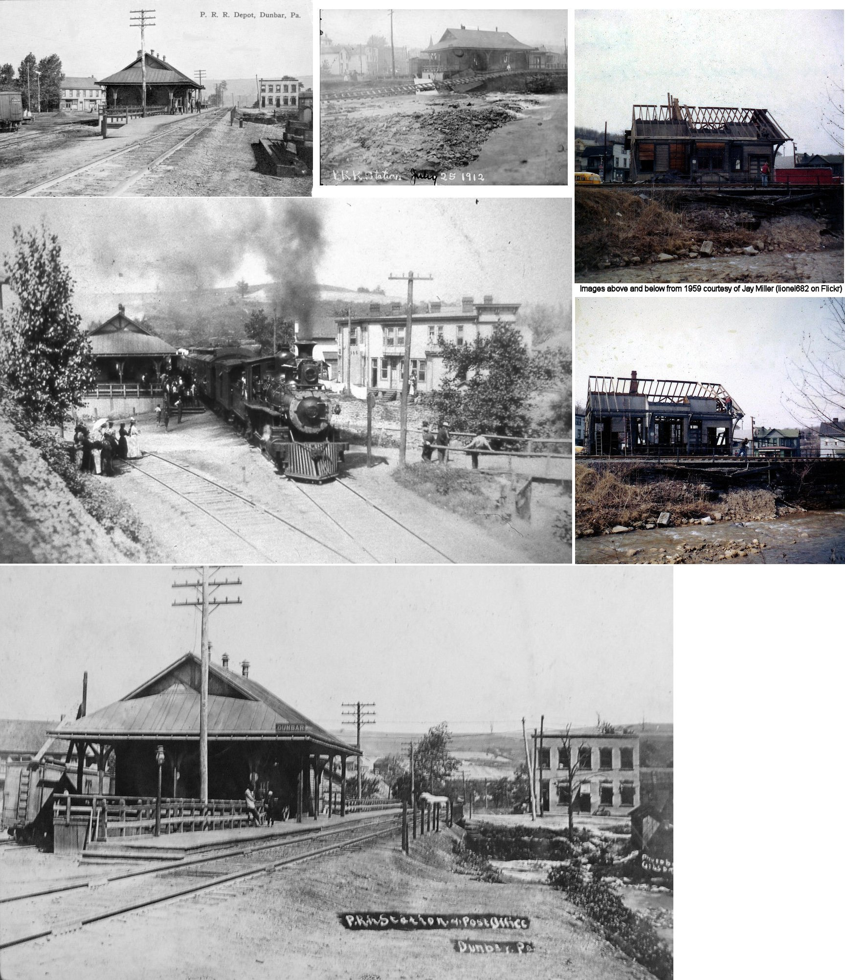
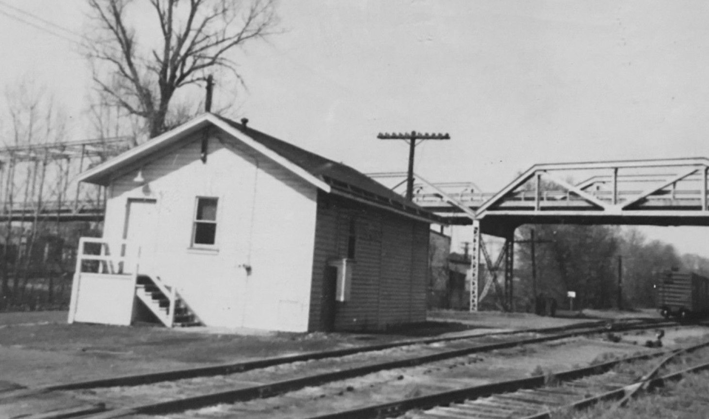
| Dunbar | |
This station was on Railroad Street on the east side of the tracks at GPS: 39.974486, -79.616195. | ||||||
| Dunbar | |
This station, built in 1890, was on the north side of Woodvale Street along the creek bank at GPS: 39.974238, -79.616747. It was on the SW side of the tracks just south of the trestle. The station was torn down in the spring of 1959. | ||||||
| Eagle Transfer | |
This station was between Morgan and Summit on the P&LE's Youghiogheny Northern Branch. | ||||||
| Emme Station | |
|||||||
| East California | |
|||||||
| East Fredericktown |
|
|||||||
| East Millsboro |
|
|||||||
| East Rices Landing Station |
|
|||||||
| East Riverdale |
|
|||||||
| East Roscoe | |
|||||||
| Edenborn |
|
|||||||
| Ellwell Junction | |
This was the interchange for the P&LE's Ellwell Branch and Downer Branch Extension. | ||||||
| Evans Station | |
|||||||
| Everson | |
The passenger and freight stations were northwest from the corner of Brown Street and Vance Street. They sat between the B&O and PRR tracks near the bank of the creek. The passenger station was at GPS: 40.094718, -79.589364 and the freight station was at GPS: 40.094603, -79.589486. | ||||||
| Everson | |
The passenger station was at the west end of Shipley Street on the north side of the street. The station was on the east side of the tracks at GPS: 40.093344, -79.589760. The freight station was just a bit to the north at GPS: 40.093715, -79.589717. | ||||||
| Fairbank |
|
|||||||
| Fairchance | |
This station was on the south side of Chruch Street on the SE side of the tracks at GPS: 39.819916, -79.752879. | ||||||
| Fairchance | |
This station was on the south side of Chruch Street at Deforest Aveune on the west side of the tracks at GPS: 39.820085, -79.754771. The Southwest Branch ended about a mile from the station in the SW part of town. | ||||||
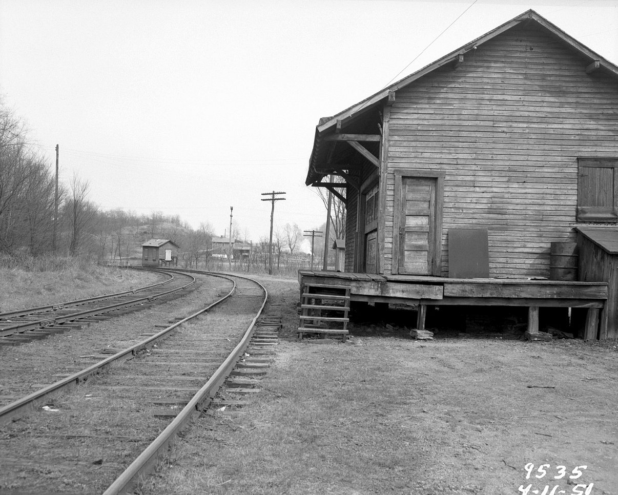
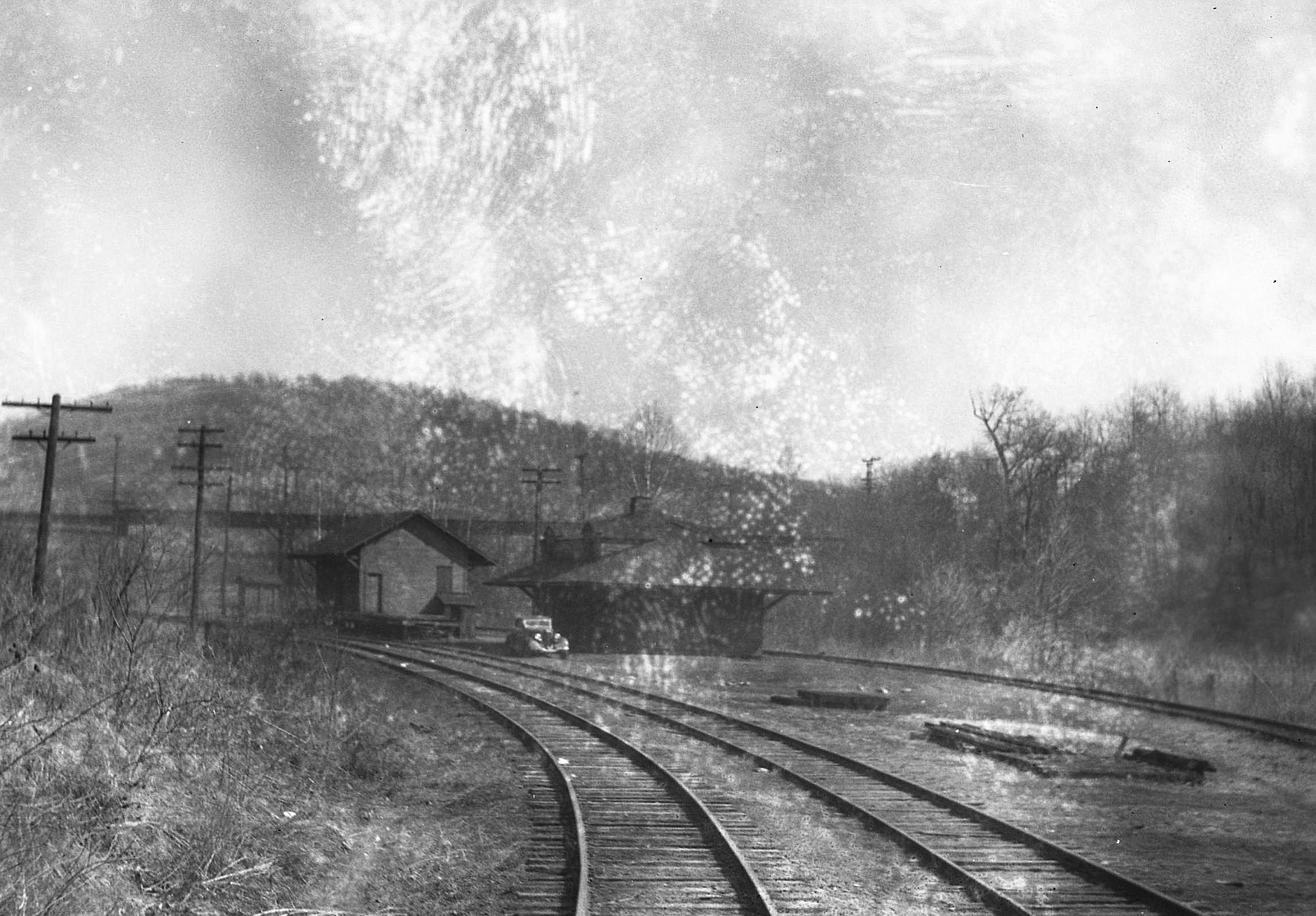
| Falls City (Ohiopyle) |
|
Falls City was an original station on the Pittsburgh & Connellsville RR. | ||||||
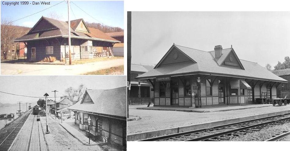
| Fayette City | |
This station sat at the corner of Union and Water Streets at GPS: 40.099132, -79.840446. It was last used as a residence and was torn down sometime between 2000-2010. | ||||||
| Footedale |
|
|||||||
| Fountain Mills Station | |
An original station on the Mt. Pleasant & Broadford RR. | ||||||
| Francis | |
This station was between Newcomer and Messmore. It is listed on the 1923 PRR list of stations and sidings on the Coal Lick Run Branch. | ||||||
| Frost's Station | |
|||||||
| Fuller | |
Fuller is now part of Perryopolis. This was on the P&LE's Downer Branch Extension. | ||||||
| Gans | |
|||||||
| Gates |
|
|||||||
| Gillespie | |
|||||||
| Gist | |
This station is listed on the 1923 PRR List of Stations & Sidings on the Southwest Branch. | ||||||
| Grays Landing |
|
|||||||
| Grindstone | |
This was on the Redstone Branch. It was the beginning of the Grindstone Branch. | ||||||
| Helen | |
This was the terminus of the Keister Branch. | ||||||
| Hickman Run | |
|||||||
| Hogsett | |
A new station was built here in 1883. | ||||||
| Horseshoe Bottom Station | |
This station was on the Confluence & Oakland Branch. | ||||||
| Huron |
|
|||||||
| Hutchinson |
|
This station was on the south side of Reservoir Road at approximately GPS: 39.864949, -79.710759. | ||||||
| Ifield |
|
This station was on the Cat's Run Branch. | ||||||
| Indian Creek Station | |
|||||||
| Indian Creek |
|
|||||||
| Indian head | Indian Creek Valley RR |
|||||||
| Iron Bridge Station | |
This was an early station on the Mt. Pleasant & Broadford RR. It was on the south bank of Jacobs Creek near where Old US 119 (Mt. Pleasant Road) crosses the creek at the RR trestle over the creek (GPS: 40.112158,-79.553477). | ||||||
| Isabella |
|
|||||||
| Kaufmann |
|
There is a station shown near where Bear Run empties into the Youghiogheny near Kaufmann. The station has no name on the map. | ||||||
| Keister Junction Station | |
|||||||
| Keisterville | |
|||||||
| Kier | |
|||||||
| La Belle |
|
|||||||
| Lake Lynn | |
|||||||
| Laurel Run | |
This station was on River Road at approximately GPS: 40.060468,-79.681118. | ||||||
| Lambert |
|
|||||||
| Landon Station | |
|||||||
| Lardin |
|
This station was ont the Moser Run Branch. | ||||||
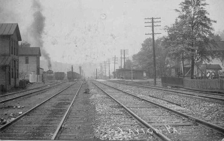
| Layton | |
There was a station on the Pittsburgh & Connellsville here as early as 1872. | ||||||
| Leckrone |
|
Here the Mon Rwy. junctioned with the B&O's Smithfield-Masontown Branch. | ||||||
| Leckrone |
|
The brick passenger station was B&O and the freight station was Monongahela Railway. | ||||||
| Leith |
|
The B&O Crossland Branch junctioned here with the Fairmont, Morgantown & Pittsburgh Branch. The station was on Cinder Road in the vicinity of GPS: 39.890787, -79.719214. | ||||||
| Leith |
|
This station was on the west side of Cinder Road in the vicinity of GPS: 39.891987, -79.720914. | ||||||
| Lemont Furnace | |
|||||||
| Lemont Furnace |
|
|||||||
| Lilly Run Junction |
|
|||||||
| Linn | |
This was on the Redstone Branch. | ||||||
| Low Phos |
|
This was a mine station at the end of the Los Phos Branch. | ||||||
| Martin |
|
|||||||
| Masontown |
|
Photos are of the passenger station and possibly two freight stations. | ||||||
| Maxwell |
|
|||||||
| Melcroft | Indian Creek Valley RR |
|||||||
| Merrittstown |
|
|||||||
| Messmore |
|
This station was on the Coal Lick Run Branch. | ||||||
| Mill Run Junction |
|
|||||||
| Miltenberger Station |
|
There are no roads to this location today. It was on the north bank of the Youghiougheny River in the SE corner of the Cunningham District of Tyrone Township. The station was on the north side of the tracks at approximately GPS: 40.053151,-79.694299. There was a station here in 1872. | ||||||
| Monarch | |
According to the 1900 PRR List of Stations & Sidings, this station was on the Opossom Run Branch. | ||||||
| Morgan Station | |
An original station on the Mt. Pleasant & Broadford RR in Upper Tyrone Township. | ||||||
| Morgan | |
This station was on the P&LE's Youghiogheny Northern Branch. | ||||||
| Moser Run Junction |
|
This station was on the Browns Run Branch. | ||||||
| Mt. Braddock | |
|||||||
| Newcomer | |
This station was on the Coal Lick Run Branch. | ||||||
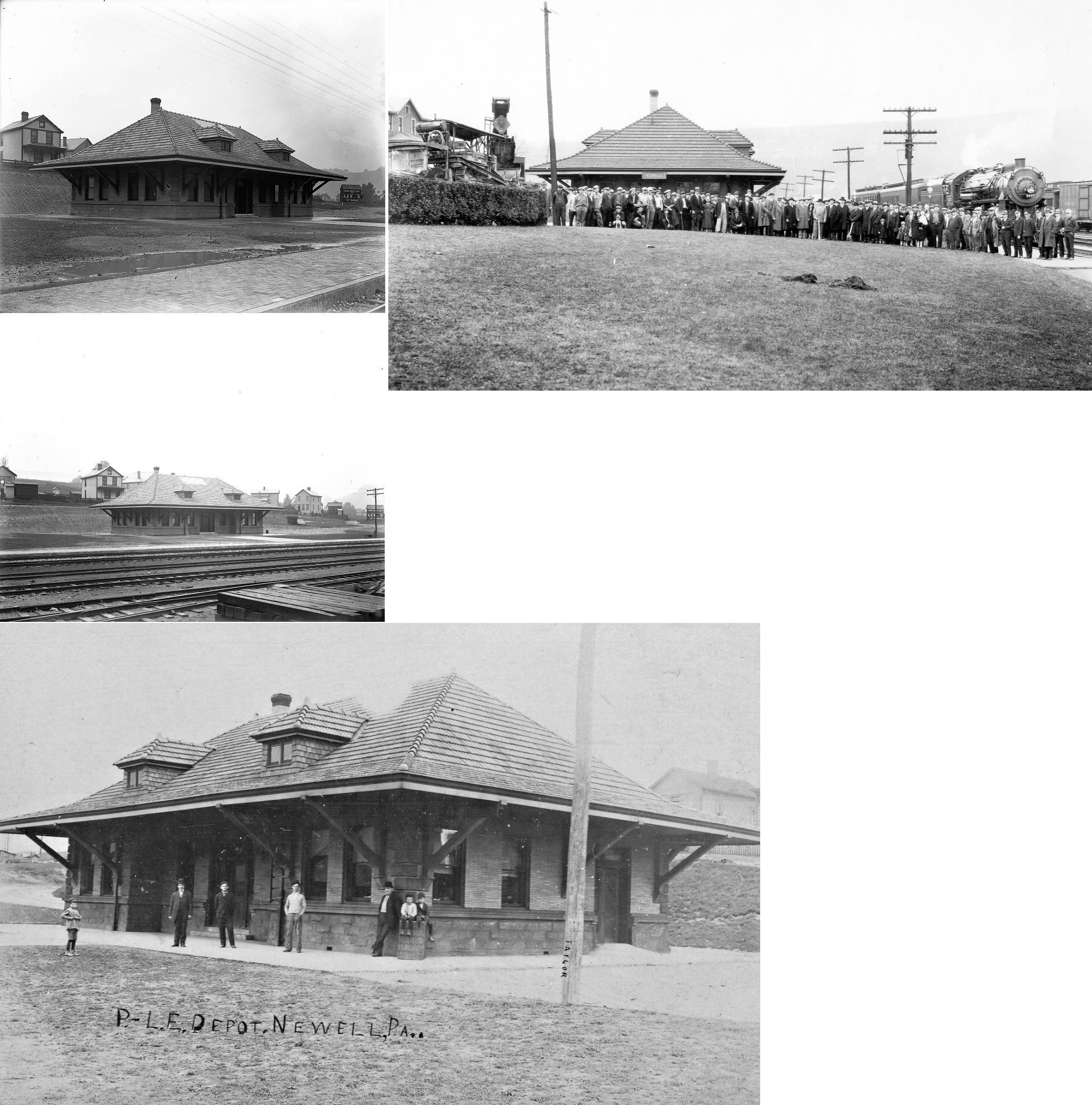
| Newell | |
|||||||
| New Geneva |
|
|||||||
| New Haven |
|
A new station was built here in 1890. | ||||||
| New Salem |
|
|||||||
| Nilan | |
This was the first station east of Point Marion on the Fairmount, Morgantown & Pittsburgh Branch. | ||||||
| Ohiopyle | |
|||||||
| Old Forts Station (Bidwell) |
|
Later known as Bidwell Station. | ||||||
| Old Home Works |
|
|||||||
| Oliphant Furnace |
|
This station was on the south side of Oliphant Road. | ||||||
| Oliphant Furnace |
|
This station was on the north side of Oliphant Road. | ||||||
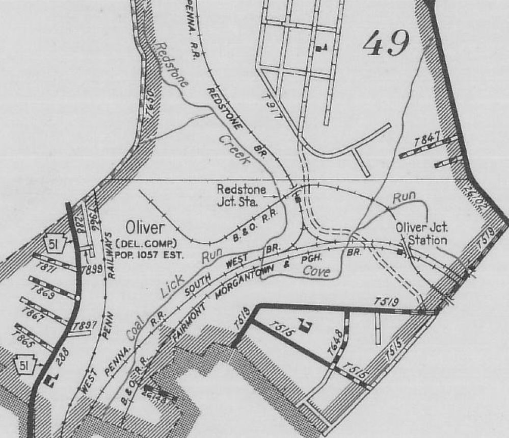
| Oliver Junction |
|
Map in image showing location of the station is from 1941. | ||||||
| Orient |
|
|||||||
| Oriental |
|
This station was just NE of Fairchance. | ||||||
| Outcrop |
|
|||||||
| Overton | |
An original station on the Mt. Pleasant & Broadford RR. | ||||||
| Pennsville | |
|||||||
| Perryopolis Junction | |
This was the junction of the P&LE's Downer Junction Branch and Ellwell Branch. | ||||||
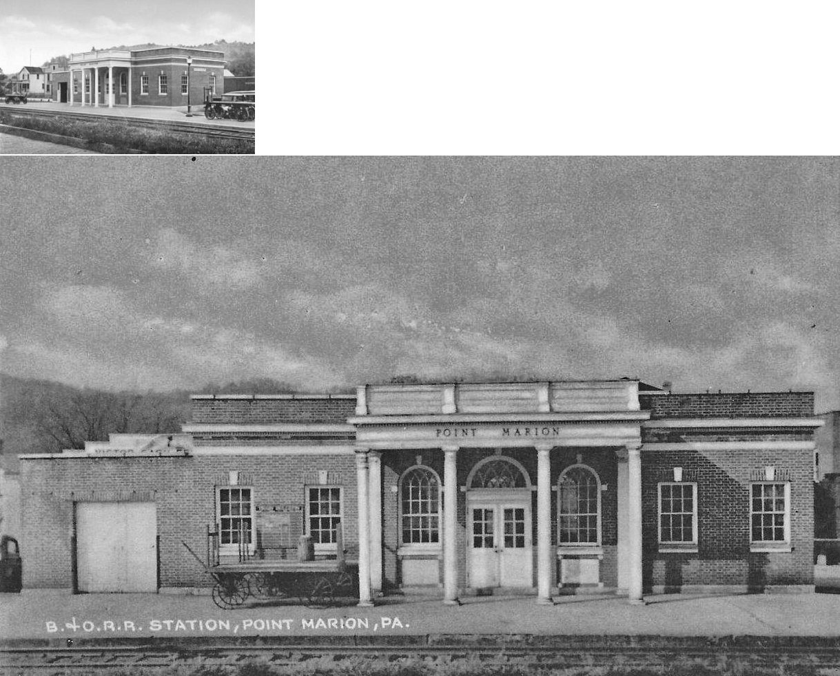
| Point Marion | |
An earlier station here was destroyed a large fire that claimed a good part of the business district and some boxcars full of dynamite on Feb. 16, 1923 (New Castle News, 02-16-1923). | ||||||
| Point Marion | |
This station, built in 1925, was on the west side of the tracks at the corner of Penn Street and Railroad Street (GPS: 39.739001, -79.899831). | ||||||
| Ralph |
|
This was on the Lilly Run Branch. | ||||||
| Redstone Junction | |
Map in image showing location of the station is from 1941. The station was built in 1883. This is where the Southwest branch junctioned with the Redstone Branch. | ||||||
| Republic |
|
|||||||
| Rogers Mill | Indian Creek Valley RR |
|||||||
| Ronco |
|
|||||||
| Round Bottom | |
|||||||
| Rowes Run | |
This was on the PRR's Grindstone Branch. | ||||||
| Rowest |
|
|||||||
| Royal | |
This station is listed on the 1923 PRR List of Stations & Sidings as the terminus of the Grindstone Branch. | ||||||
| Sagamore | Indian Creek Valley RR |
|||||||
| Salem |
|
|||||||
| Sand Rock | |
|||||||
| Simpson |
|
This station, likely a flagstop, was on the Dunlaps Creek Division between Allsion and Brownsville. | ||||||
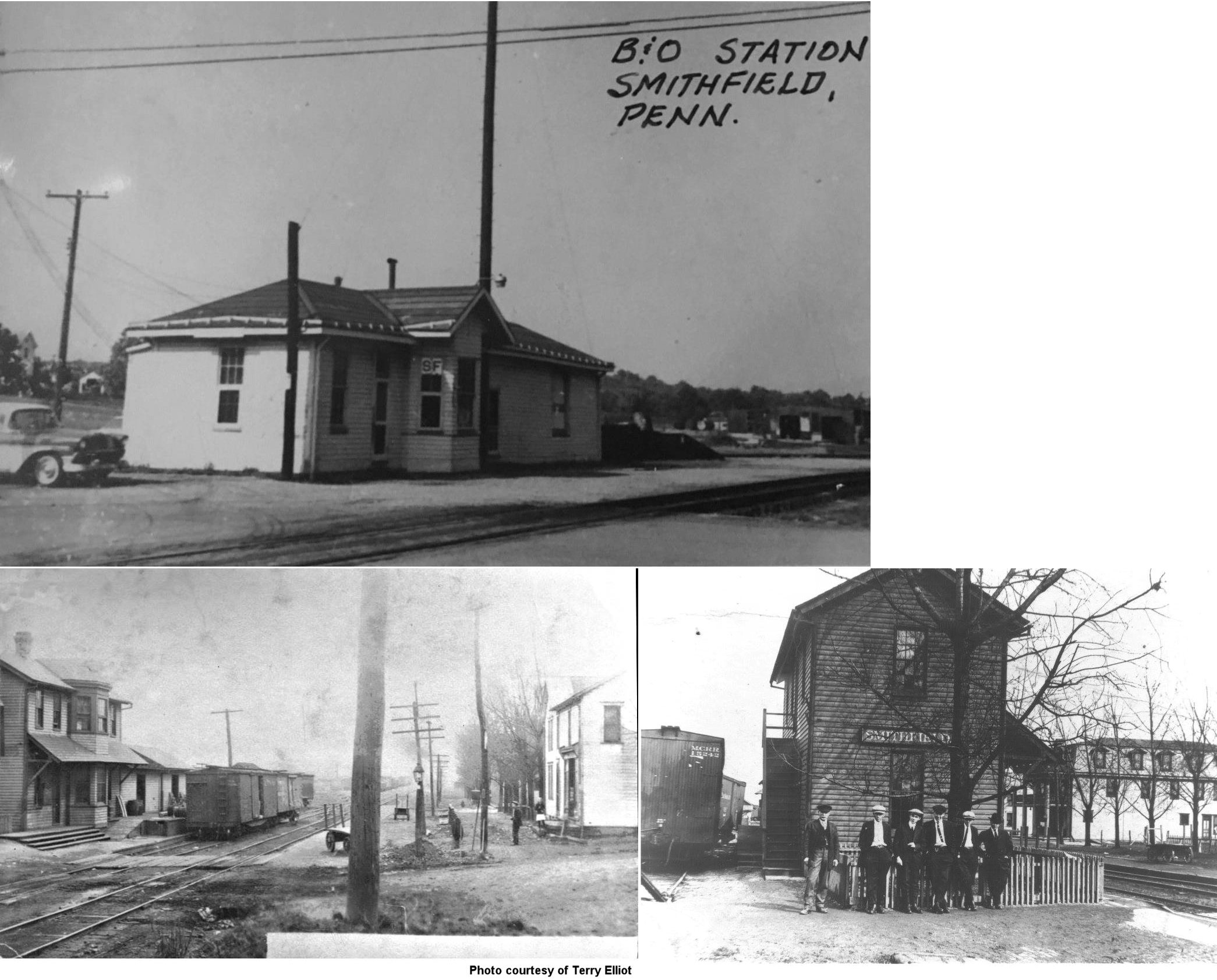
| Smithfield | |
This station was on the east side of Liberty Street on the north side of the tracks at GPS: 39.796897, -79.801966. In its early years, the station had a second story. | ||||||
| Smock | |
This was on the Redstone Branch. | ||||||
| Speedway | |
This station was between Leith and Brownfield on the Southwest Branch. | ||||||
| Stambaugh | |
This station is listed on the 1923 PRR List of Stations & Sidings on the Southwest Branch. | ||||||
| Star Junction | |
This was on the P&LE's Ellwell Branch. | ||||||
| Stewarton | |
|||||||
| Stewarton |
|
|||||||
| Summit | |
This station was on the P&LE's Youghiogheny Northern Branch. | ||||||
| Thaw | |
This was on the Redstone Branch. | ||||||
| Tintsmans Station | |
An original station on the Mt. Pleasant & Broadford RR. | ||||||
| Tippecanoe | |
This was on the Redstone Branch. | ||||||
| Tremont | |
|||||||
| Trotter | |
This station is listed on the 1900 and 1923 PRR List of Stations & Sidings on the six-mile-long Opossum Run Branch. | ||||||
| Tub Run Station | |
This station was just nortyh of Thomasdale. | ||||||
| Tyrone Station | |
Shown on the early county maps, this was in the vicinity of Broadford and may have been the same station as Adelaide. | ||||||
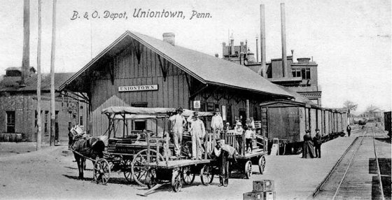
| Uniontown | |
This original frame passenger station was on the east side of Beeson Street just north of West Penn Street at GPS: 39.902636, -79.725504. It is shown on the 1896 map of the city. When the new brick station was built, this station received an addition and became a freight station thereafter. | ||||||
| Uniontown | |
The original freight station here burned down on April 13, 1895. The frame passenger station (listed above) also incurred some minor damage from the fire. | ||||||
| Uniontown | |
This brick passenger station was built between 1901 and 1907. It was on the north side of Redstone Creek between Beeson Avenue and North Gallatin Avenue at GPS: 39.903559, -79.724945. It was a freight-only station by 1925. | ||||||
| Uniontown | |
There were two wooden freight stations that were on the north side of Penn Street on the east side of Beeson Avenue at GPS: 39.902597, -79.725302. The freight houses stretched from Penn Street to Redstone Creek. | ||||||
| Uniontown | |
The original South West Pennsylvania RR passenger staion was at the intersection of Beeson Street (formerly Broadway Street) and Main Street at approximately GPS: 39.901127, -79.725402. This 2-story station is shown on the 1886 map. | ||||||
| Uniontown | |
On the 1891 map a new, larger passenger station is shown on the same block as the original station, but slightly to the SE at GPS: 39.900915, -79.725050. The canopy of this new station spanned the east side of Beeson Street between Main Street and East South Street. This station was built in 1888 and opened in February 1889. | ||||||
| Uniontown | |
The original South West Pennsylvania RR freight staion was at the corner of Beeson Street (formerly Broadway) and West Penn Street at GPS: 39.902347, -79.725885. This station is shown on the 1886 map. | ||||||
| Uniontown | |
On the 1891 map, a new freight station with a different profile is shown at the same location as the original freight station. Between 1907-1914 this second generation station was torn down when the new, longer, third-generation freight warehouse (which is still standing) was built. | ||||||
| Uniontown (South Uniontown) |
|
This station was on the west bank of Coal Lick Run between West Main Street and West Fayette Street at GPS: 39.900606, -79.730800. | ||||||
| Upper Middletown | |
This station was east of town on Upper Middletown Road. This was on the Redstone Branch. | ||||||
| Vance Mill Junction (Bute Run Jct.) |
|
A new station was built here in 1884. This was the beginning of the Vance Mill Branch off the Redstone Branch as well as the nearby Bute Run Branch. | ||||||
| Vanderbilt | |
This was on the P&LE's Dickerson Run Branch. | ||||||
| Victoria Station | |
A.K.A. Salt Spring Bottom. | ||||||
| Walker | |
This was on the Redstone Branch. | ||||||
| Walnut Hill Station | |
This station was on the Coal Lick Run Branch. | ||||||
| Waltersburg | |
This was on the Redstone Branch. | ||||||
| Washington Mines | |
This was on the P&LE's Ellwell Branch. | ||||||
| Watson Station | |
This was the last station on the Confluence & Oakland Branch before the Maryland state line. | ||||||
| White Bridge Station |
|
Shown on the 1941 county map. | ||||||
| Whitsett Junction | |
This was on the P&LE's Ellwell Branch. | ||||||
| Wickhaven Station | |
|||||||
| Young | |
This station was NW of Stewarton station. | ||||||
| 1895 FAYETTE COUNTY RAILROAD MAP | ||||||||
 |
||||||||
| Notes About Existing
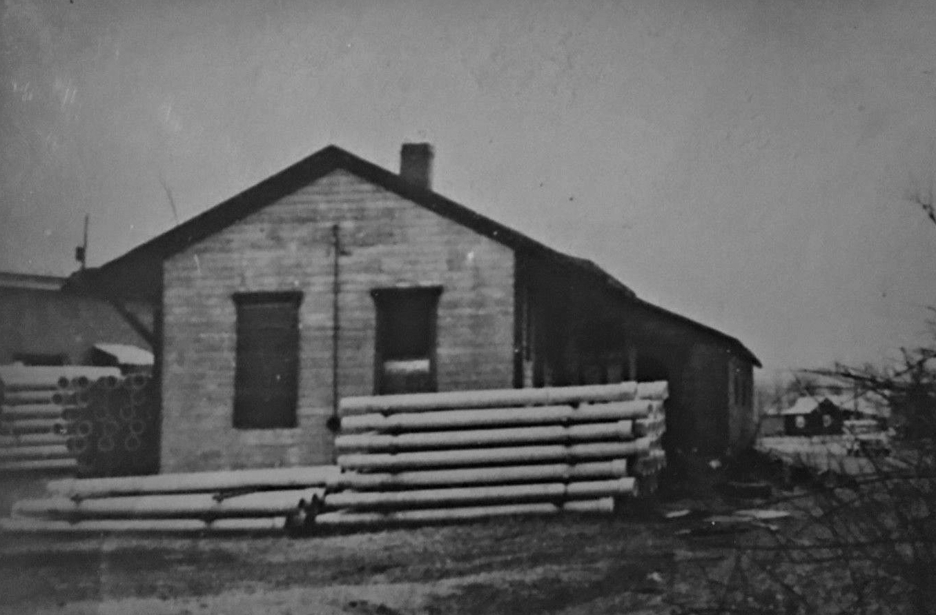
Stations... Brownsville (Union) - This is a large office building on the main street through Brownsville that now houses a multitude of businesses. Until the takeover of the Monongahela Railway by Conrail in 1993, it also served as the operational headquarters of the Mon Rwy. This station served the PRR, P&LE and Monongahela Railway. The express agency/baggage building also still stands to the north at GPS: 40.022967, -79.885629. Connellsville (P&LE) - This is the older pre-1911 P&LE station. It was built in 1907. A board was found inside a wall that a worker had put in while building it. It was dated July 30, 1907. Station was shared with the Western Maryland. Originally used for passenger and freight, and later used just for freight when the new station opened a few blocks east. Because it was originally built for passengers, the front half interior is all wood. The walls and ceiling are tongue and groove boards with a bead. The floor is 1" thick tongue and groove boards. There is a basement under the front half. Originally a loading dock came out under the rear door from the baggage/freight section to where the tracks came up to the back of the building. There is a built in desk and a ticket window inside. --Mark Rowan Ohiopyle (WM) - Building used as a state park info center. ROW owned by a rails-to-trails group. |
||||||||