|
|
||||||||
| EXISTING STATIONS | ||||||||
|---|---|---|---|---|---|---|---|---|
| Station Name |
Original Railroad |
Current Location |
Type | Current Use |
Date Built |
Track Status |
Building Material |
More Info |
| Elizabethville |
 |
South Market & Railroad Streets (GPS: 40.547918, -76.811138) |
C | Business | 1872 | Gone | Wood |
|
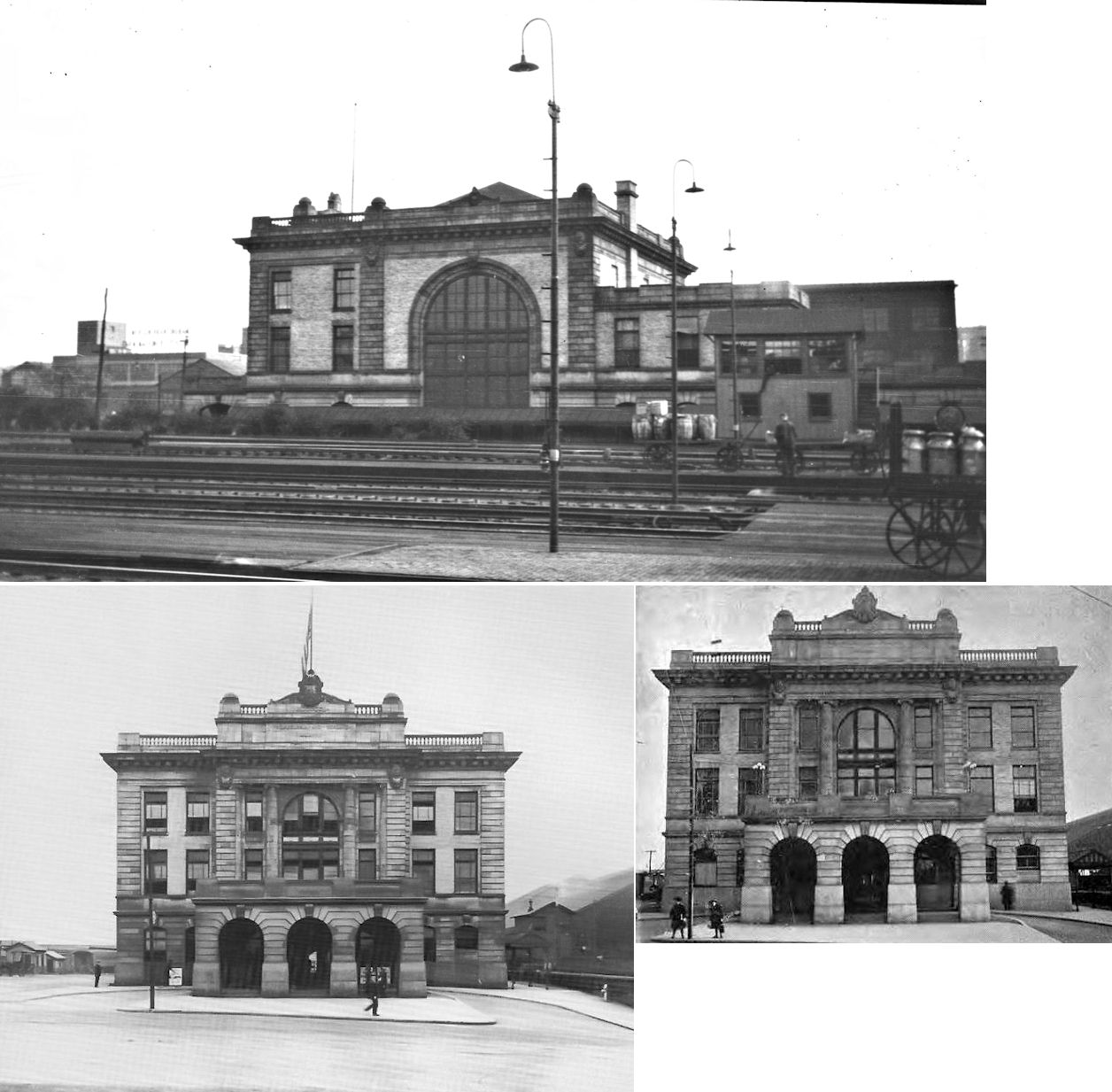
| Harrisburg |
|
Aberdeen Street at Market and Fourth Streets (GPS: 40.262116, -76.878189) |
P | Railroad | 1887 | In Use | Brick |
|
| Lykens |
|
Arch Street at Market Street (GPS: 40.566210, -76.700213) |
C | Museum | 1892 | Gone | Wood | |
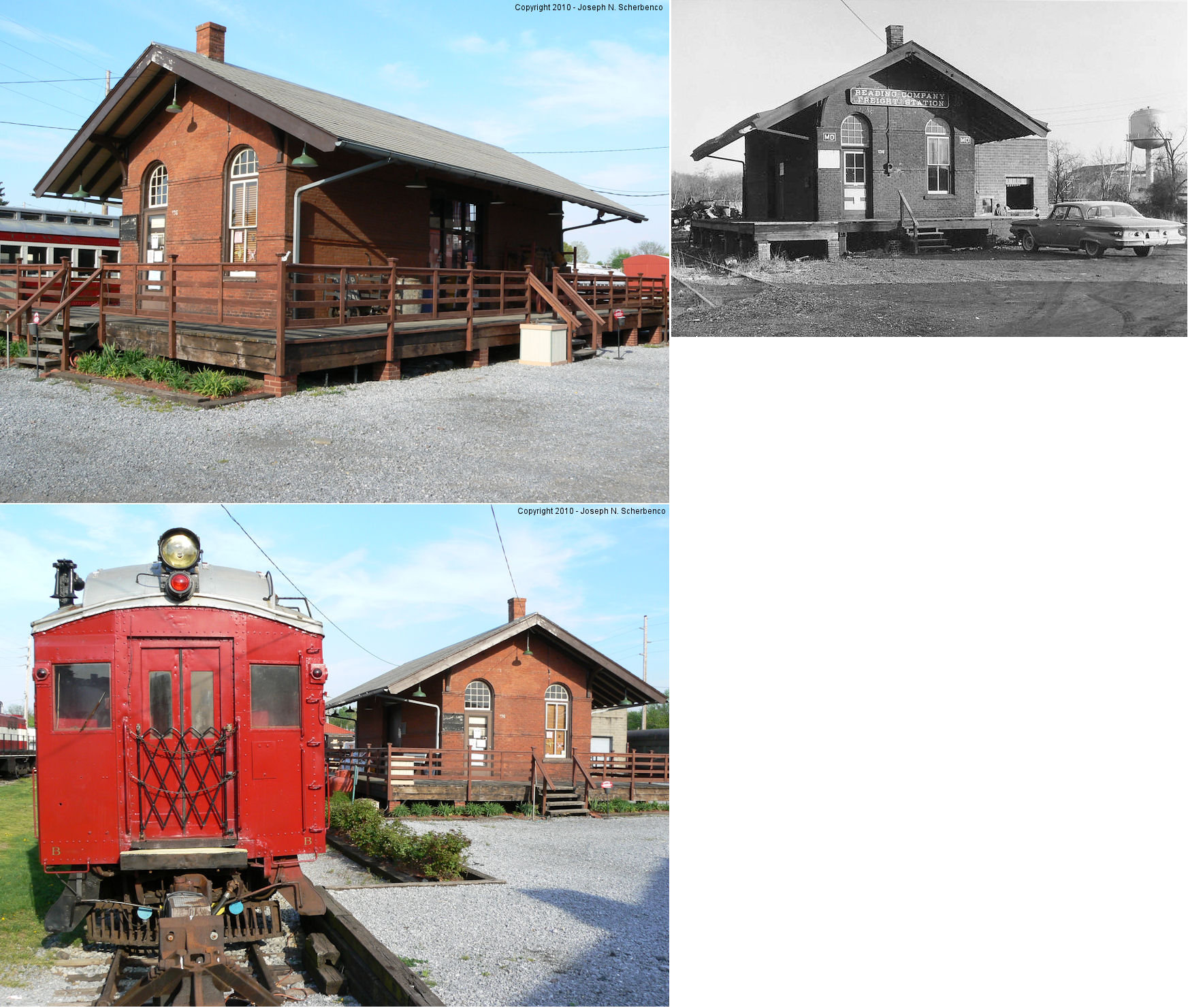
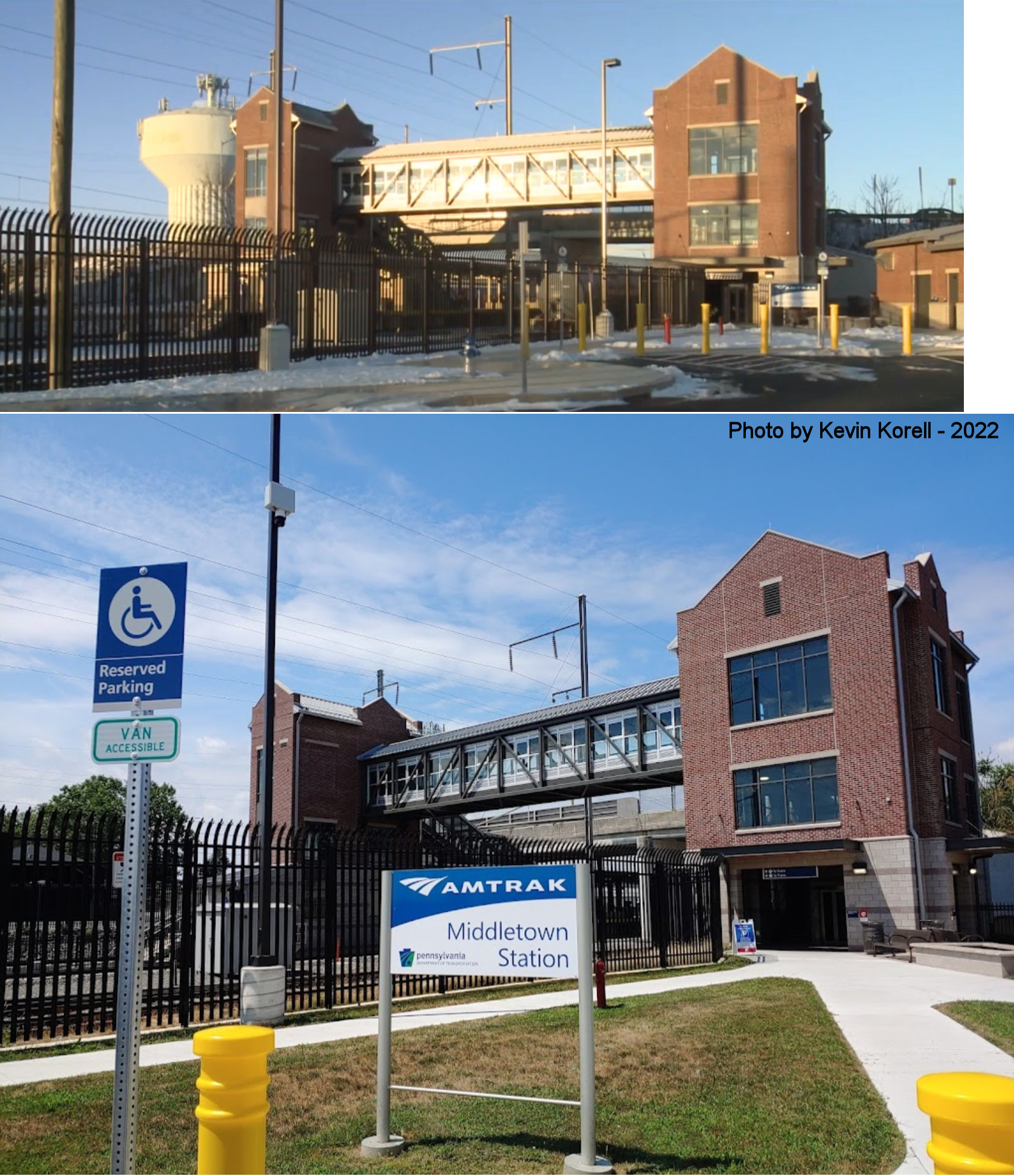
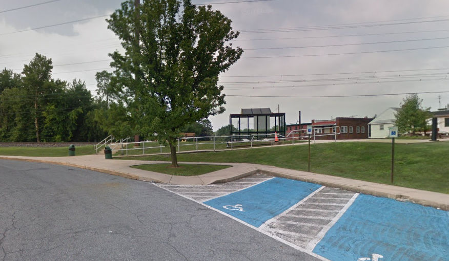
| Middletown |
 |
136 Brown Street (GPS: 40.193498, -76.728685) |
F | Railroad | 1896 | In Use | Brick |
|
| Middletown |
|
Wilson Street between Union Street and Catherine Street (GPS: 40.193793, -76.732738) |
F | Business | ???? | In Use | Wood | |
| Middletown |
 |
West Emaus Street at West Main Street (GPS: 40.196447, -76.738695) |
P | Railroad | 2022 | In Use | Brick | |
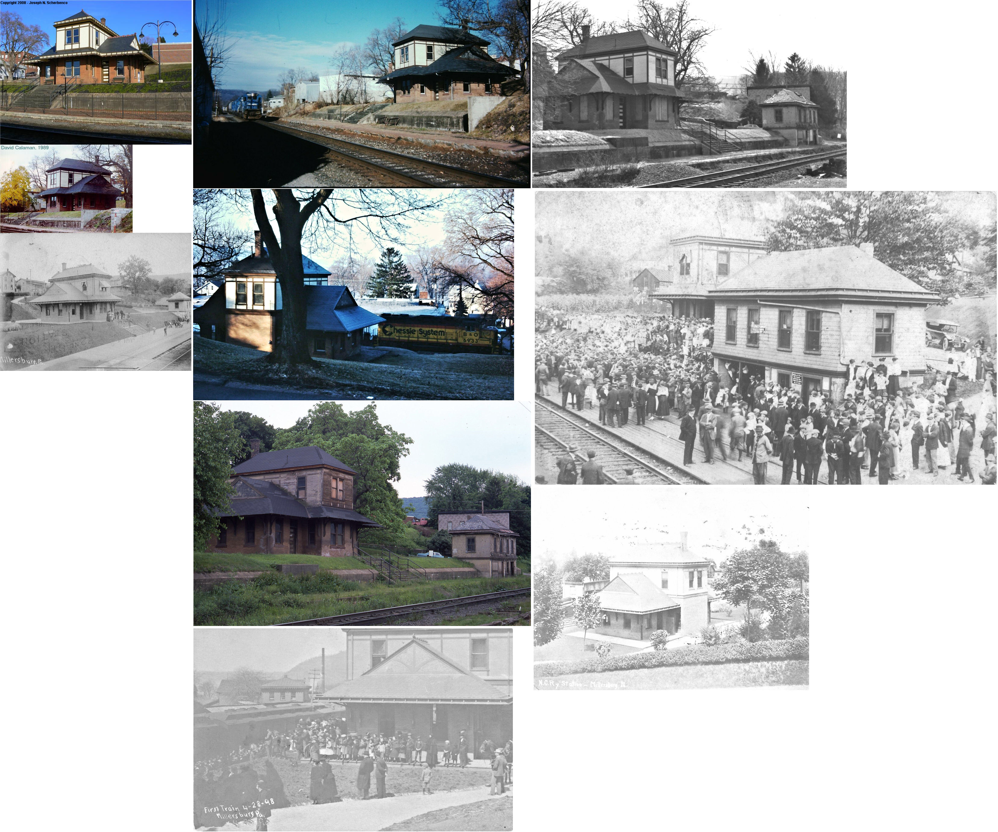
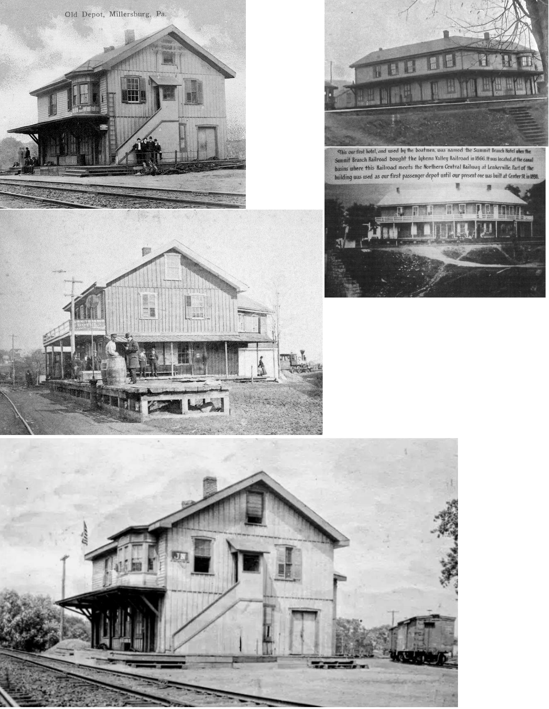
| Millersburg |
|
North side of West Center Street (GPS: 40.540186, -76.962829) |
P | Society | ???? | In Use | Brick | |
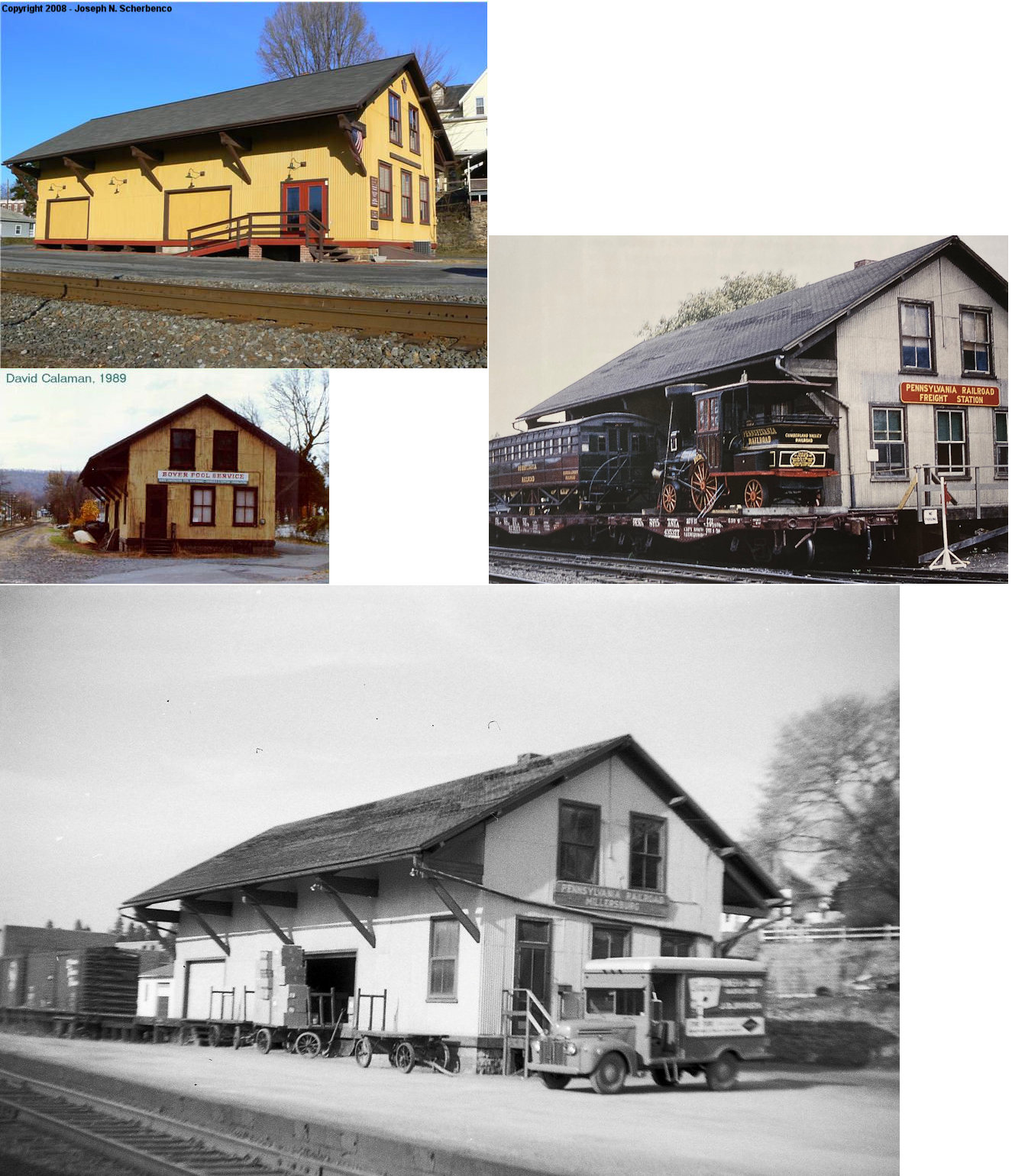
| Millersburg |
|
183 Moore Street (GPS: 40.542264, -76.962827) |
F | Business | ???? | In Use | Wood | |
| Swatara |
|
NE side of Hockersville Road & Railroad Street (GPS: 40.279518, -76.665755) |
P | Business | 1921 | In Use | Brick | |
| STATIONS OF THE PAST | ||||||||
| Station Name |
Original Railroad |
Notes | ||||||
| Beaver Creek (Beaver Sta.) |
 |
As shown on the 1875 map, there was an early station here on the Lebanon Valley Branch east of Pleasant view Road on the north side of the tracks at approximately GPS: 40.268837, -76.740211. This was originally known as Beaver Station. | ||||||
| Beaver Creek |
|
The name Beaver Station was changed to Beaver Creek in 1900 to avoid confusion with Beaver Station on the Wilmington & northern Branch. | ||||||
| Boyd |
|
|||||||
| Brownstone |
|
|||||||
| Bucklock Station |
|
An early station is indicated here on the 1875 map. This station was south of Royalton near the intersection of River Road and South Geyers Church Road at approximately GPS: 40.164860, -76.718736. The station does not appear on later maps from 1926 or 1941. | ||||||
| Budds Siding |
|
Not sure if there was a station here. It was between Lykens and Dayton Station. | ||||||
| Clarks Ferry |
 |
|||||||
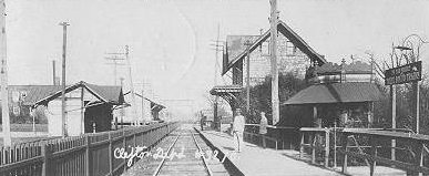
| Clifton |
|
This station was on the south side of Fulling Mill Road at approximately GPS: 40.230206, -76.727359. A station is shown here on the 1941 county map. | ||||||
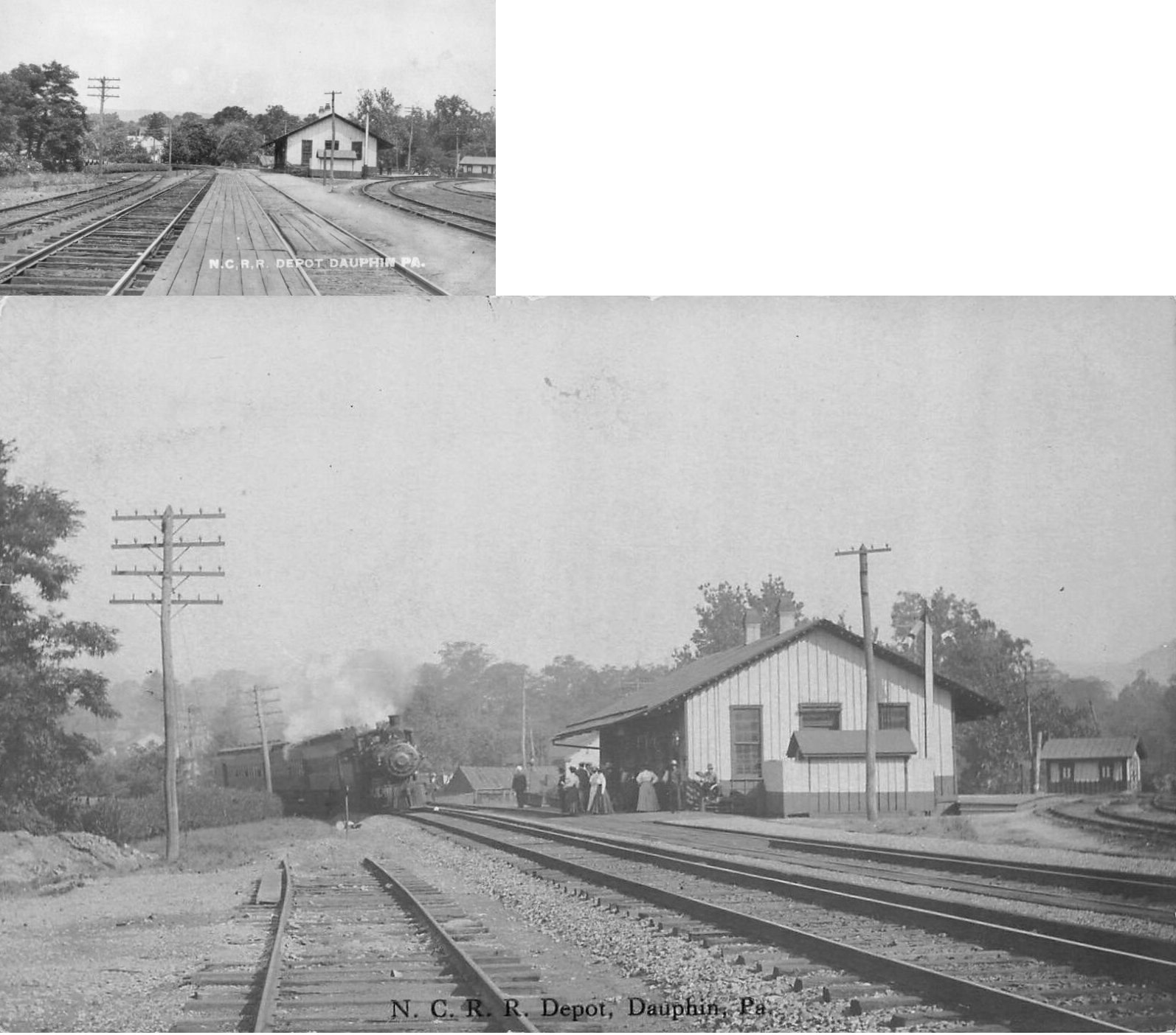
| Dauphin |
|
The first station here was on the old right of way (the tracks ran along Allegheny Street). The station was near the east end of Allegheny Street just across Stony Creek at approximately GPS: 40.364745, -76.928118. It was built around 1859. | ||||||
| Dayton |
|
. | ||||||
| Dayton Station |
|
This station was north of US-209 in the vicinity of GPS: 40.573305, -76.640837. It was on the north side of the tracks. This station is shown on the 1926 county map on the Williams valley Branch of the Reading. | ||||||
| Docklow |
|
This was the first station east of Steelton. There was a bad wreck here on Jan. 20, 1893. | ||||||
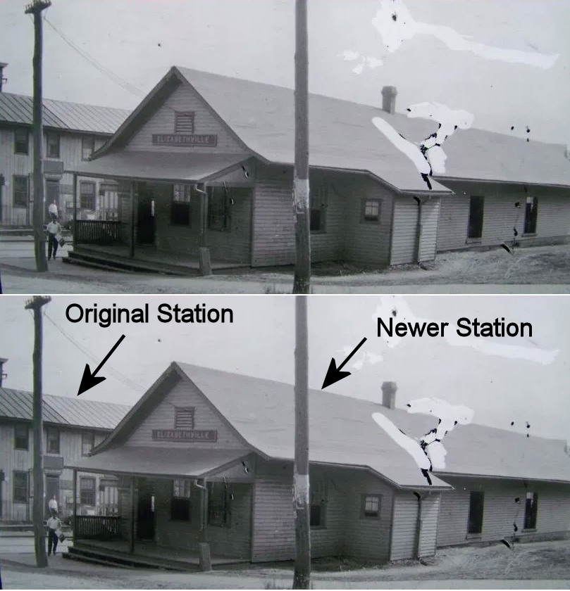
| Elizabethville |
|
The first station here was built in 1858. | ||||||
| Ellendale Forge |
|
This station was on the Schuylkill & Susquehanna Branch. It was near where Stony Creek Road turns into Ellendale Road around GPS: 40.398566, -76.853874. | ||||||
| Fairview |
|
The first station here was built in 1859. A new station was built in 1887. | ||||||
| Freys Grove |
|
This station was on Frey's Grove Lane at approximately GPS: 40.212724, -76.721943. A station is shown here on the 1941 county map. | ||||||
| Green Fields |
|
A shelter was built here in 1893. It was south of the intersection of Market Street and Cemetery Road at around GPS: 40.581072, -76.603951. This station is shown on the 1941 map. | ||||||
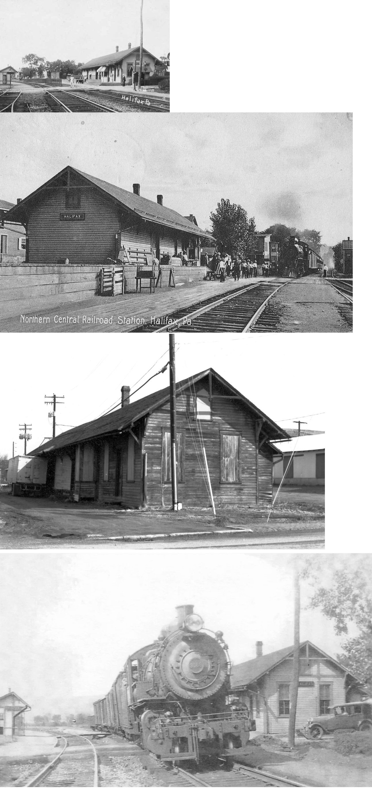
| Halifax |
|
The first station here was built in 1859. A new station was built in 1884 (likely the one pictured). It was on the north side of Armstrong Street on the east side of the tracks at GPS: 40.470420, -76.933369. | ||||||
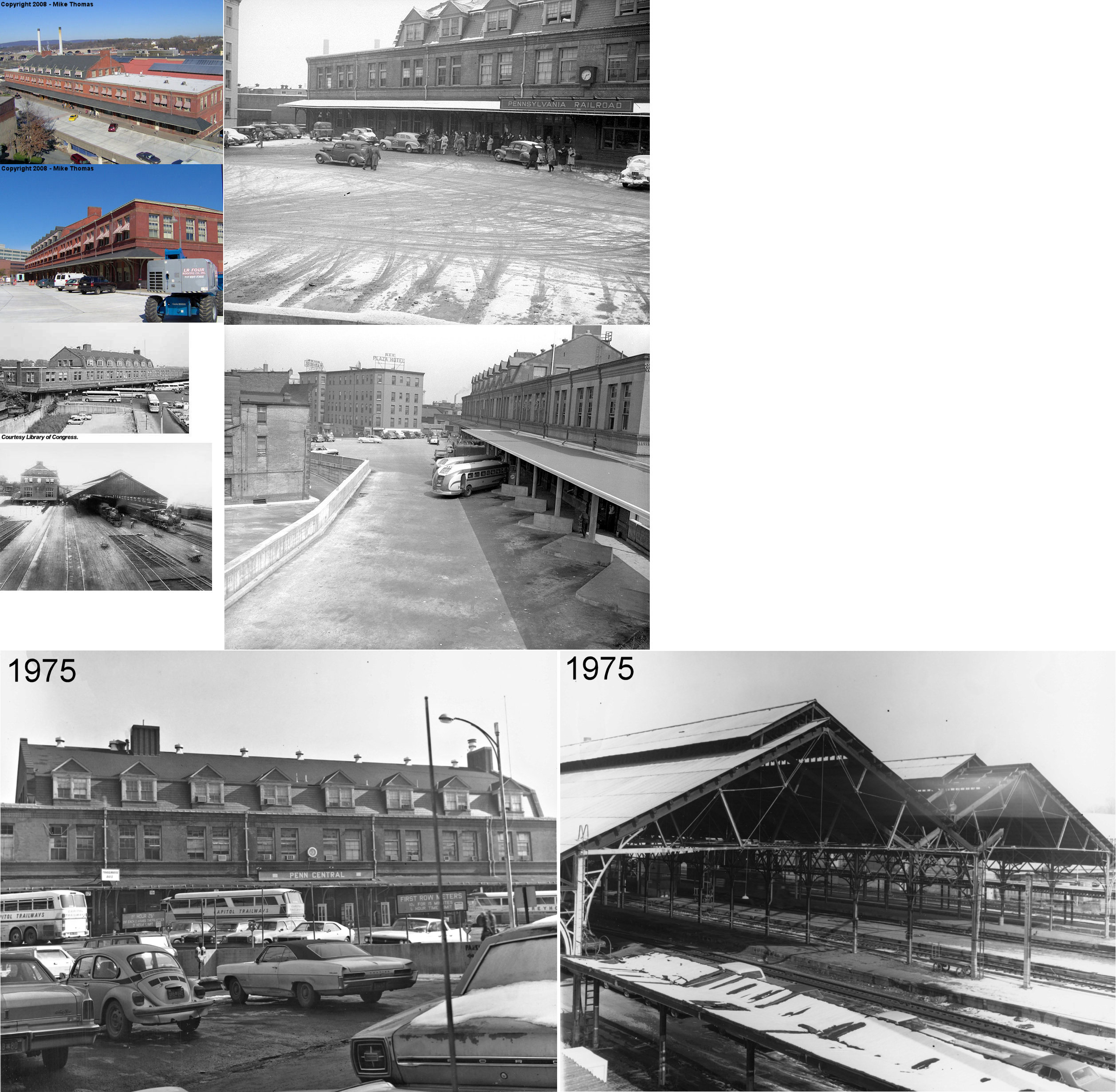
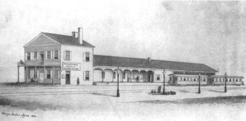
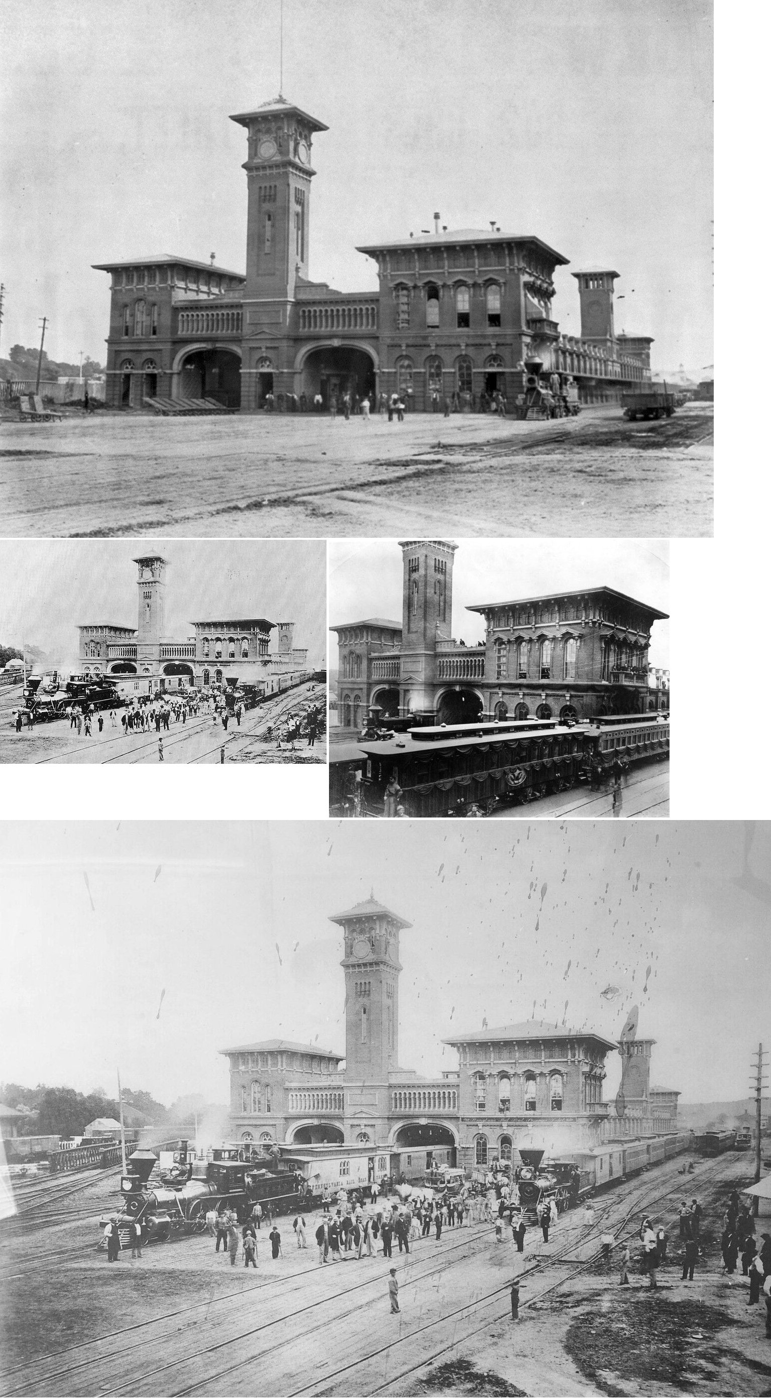
| Harrisburg |
|
The first Reading station at Harrisburg was built in 1871. It was a large combination frame structure at Market and 6th Streets at GPS: 40.263833, -76.878298 | ||||||
| Harrisburg |
|
In 1891 a temporary passenger station was built at 2nd Street near front Street with the intention of building a larger, permanent structure there. The original station was relagated to handling freight only. The plan to build a new station on 2nd Street never materialized and after only two years of service, the temporary station was shut down and passenger service resumed at the original station at Market and 6th Streets until 1902 when a permanent replacement was finally built (see listing below). | ||||||
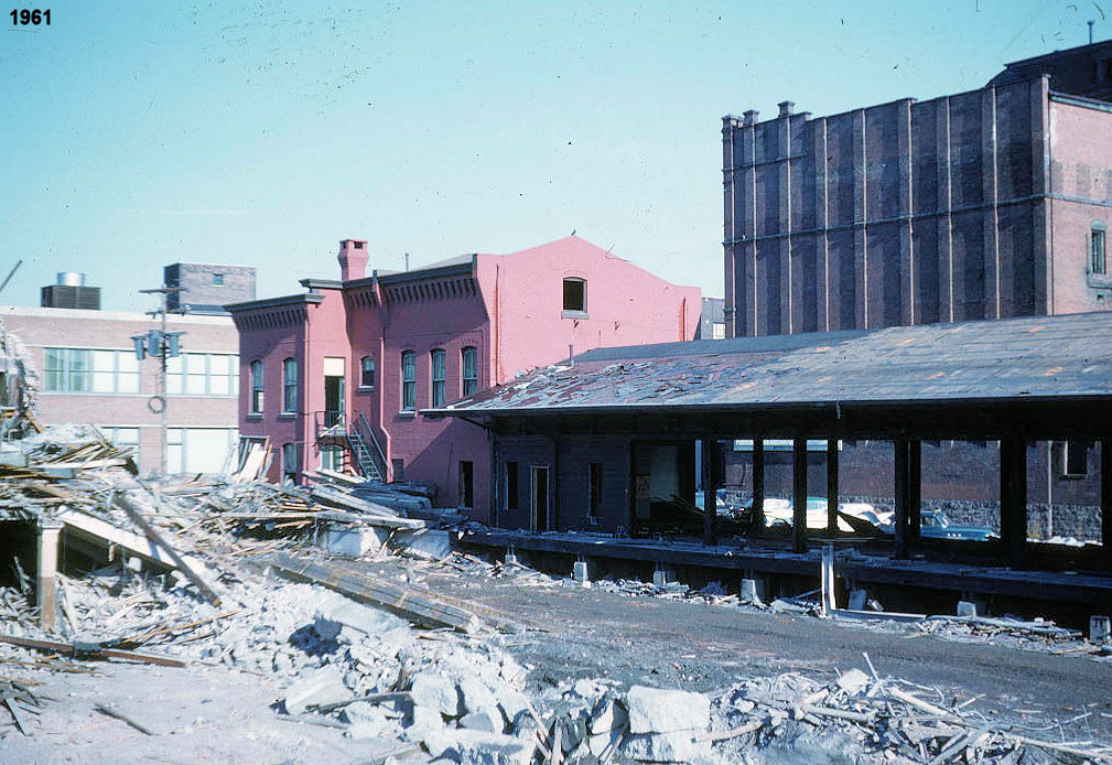
| Harrisburg |
|
This station, built in 1902, was at Market Street west of 10th Street. It was demolished in the early 1960s to build the post office. | ||||||
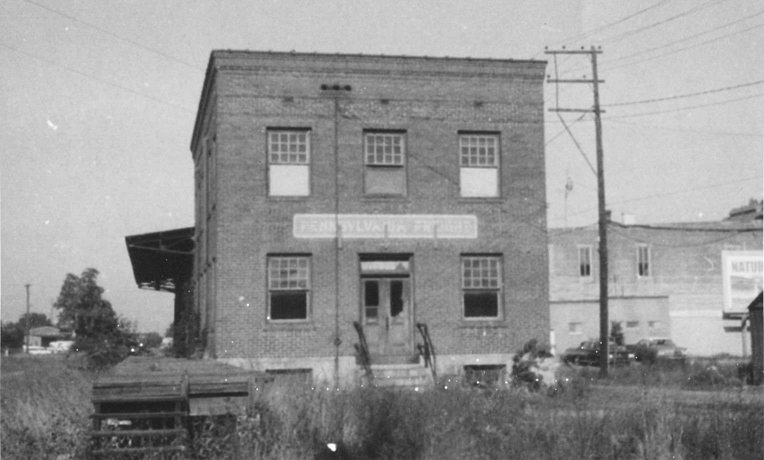
| Harrisburg |
|
This freight station was on the south side of Market Street west of 10th Street at GPS: 40.263741, -76.876626. | ||||||
| Harrisburg |
|
There was a freight station on the south side of Market Street on the NE side of the Pennsylvania Canal at GPS: 40.263668, -76.876212. This station is shown on the 1884 and 1890 Sanborn maps and the 1901 city map. | ||||||
|
Harrisburg (Allison Hill) |
|
The Allison Hill Freight Station was on the south side of Chestnut Street at 16th Street at GPS: 40.265720, -76.865684. It was built in 1910 (Reading Times, 10-14-1910). | ||||||
| Harrisburg |
|
This was the first station in Harrisburg, built in 1837 by the predecessor Harrisburg, Portsmouth, Mountjoy and Lancaster RR. | ||||||
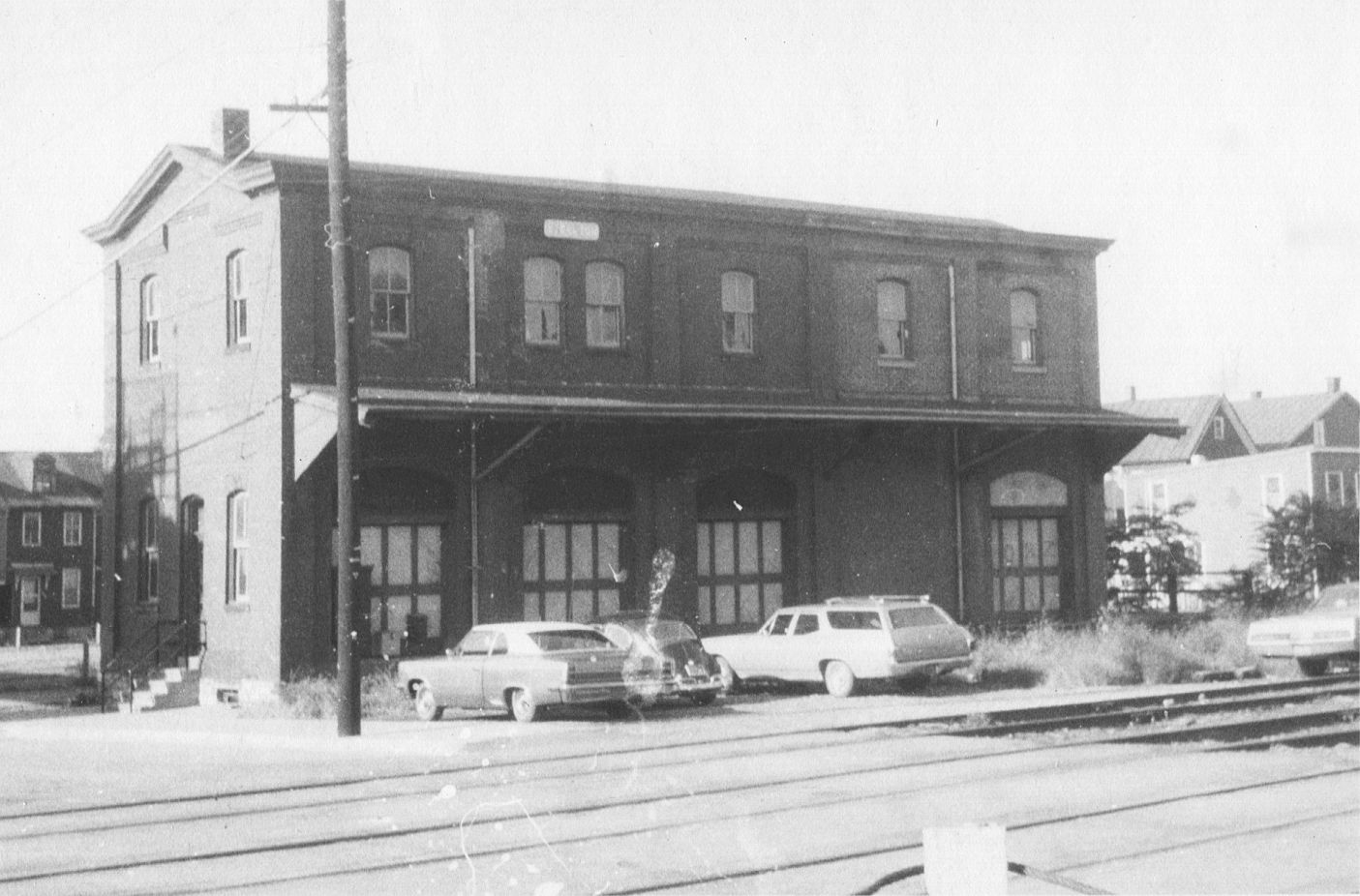
| Harrisburg |
|
This was the second PRR station in Harrisburg. It opened on August 1, 1857. It was owned by the Harrisburg & Lancaster RR and leased to the PRR and also used by the Cumberland Valley RR and the Northern Central RR. It was located east of the intersection of Market Street and 5th Street at GPS: 40.262935, -76.877891. | ||||||
|
Harrisburg (Maclay Street) |
|
There was a station on the north side of Maclay Street east of 7th Street on the west side of the tracks at GPS: 40.281492, -76.887637. It was built in 1892. | ||||||
|
Harrisburg (Maclay Street) |
|
There was a freight station just to the NW of the passenger station. It was on the east side of North 7th Street between Oak and Ivy Streets at GPS: 40.281802, -76.888247. This station is shown on the 1922 Sanborn map. | ||||||
| HArrisburg |
|
There was a freight station at what is now the corner of Mary Street and 3rd Street at GPS: 40.258791, -76.877219. This station is shown on the 1901 city map. | ||||||
| Harrisburg |
|
A westbound freight station was built west of Asylum Road in 1883. | ||||||
|
Harrisburg (Lochiel) |
|
The 1889 Frederick B. Roe, Plat Atlas Map of the City of Harrisburg shows this small station across the tracks from the Lochiel Rolling Mill. This is the current (2022) location of the Ames Plant off of PA220 (South Cameron Street). The station was at approximately GPS: 40.242892, -76.862160. It was likely a waiting shelter to serve the mill and nearby indutries at the time. It is not shown on later maps. | ||||||
| Heckton |
|
This station was on the SW side on Cemetery Road at approximately GPS: 40.349509, -76.910731. A station is shown here on the 1941 map. | ||||||
| Heckton |
|
No station is shown here for the PRR on the 1941 county map. There may have been a station here at one time, or the PRR may have shared a station with the reading. Both of those are speculation. | ||||||
|
Hershey (Derry Church) |
|
The town changed its name from Derry Church to Hershey in 1906. This was about the same time this railroad station went out of service for the new Hershey station that was near the factory. | ||||||
| Hershey |
|
Built 1906, this station was east of what is now the PA743 overpass on the south side of the tracks at GPS: 40.286907, -76.650578. | ||||||
| Hershey |
|
The frieght station was east of the passenger station at GPS: 40.287335, -76.649868. | ||||||
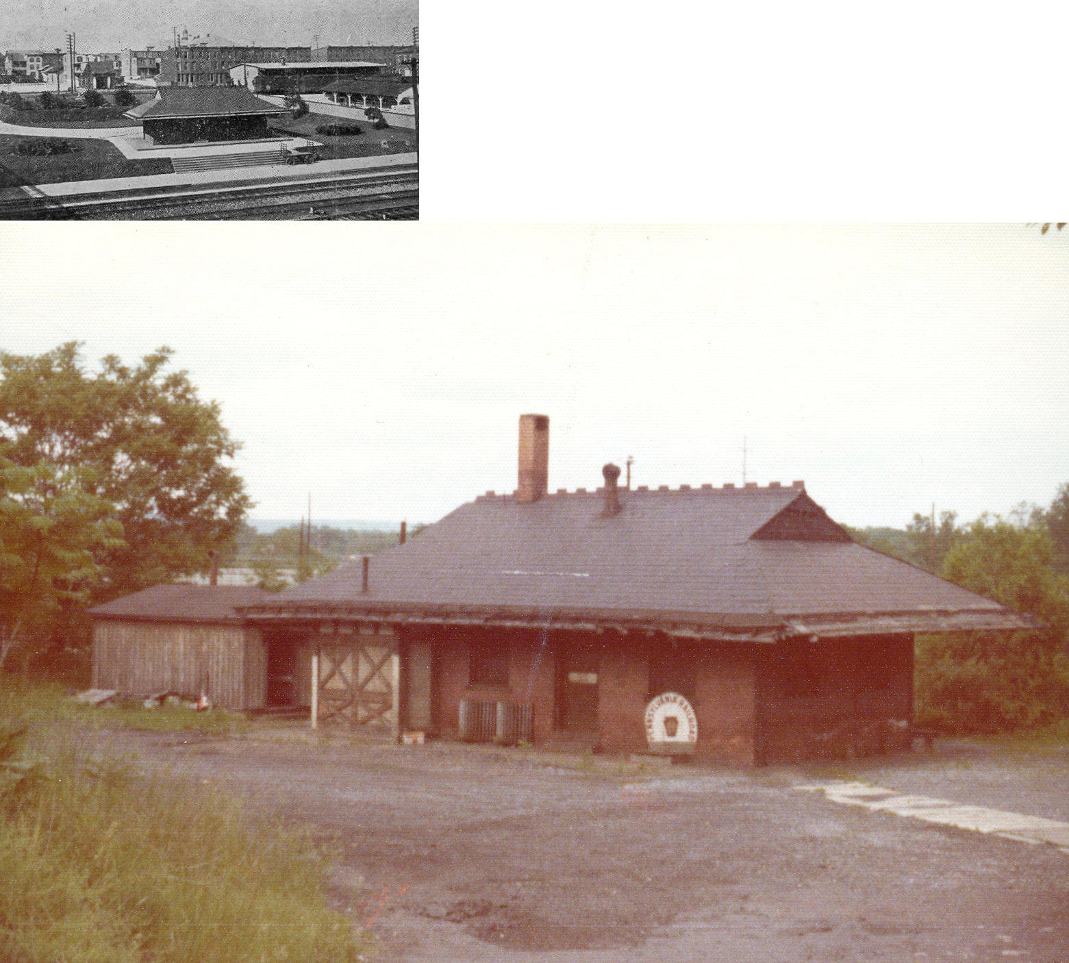
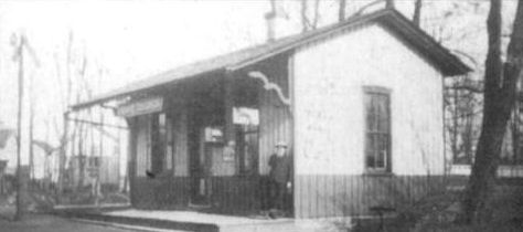
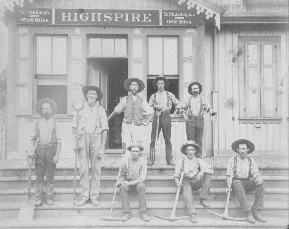
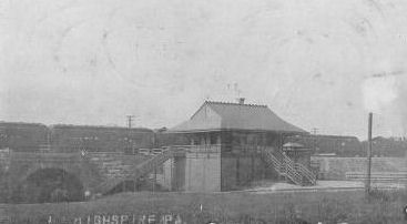
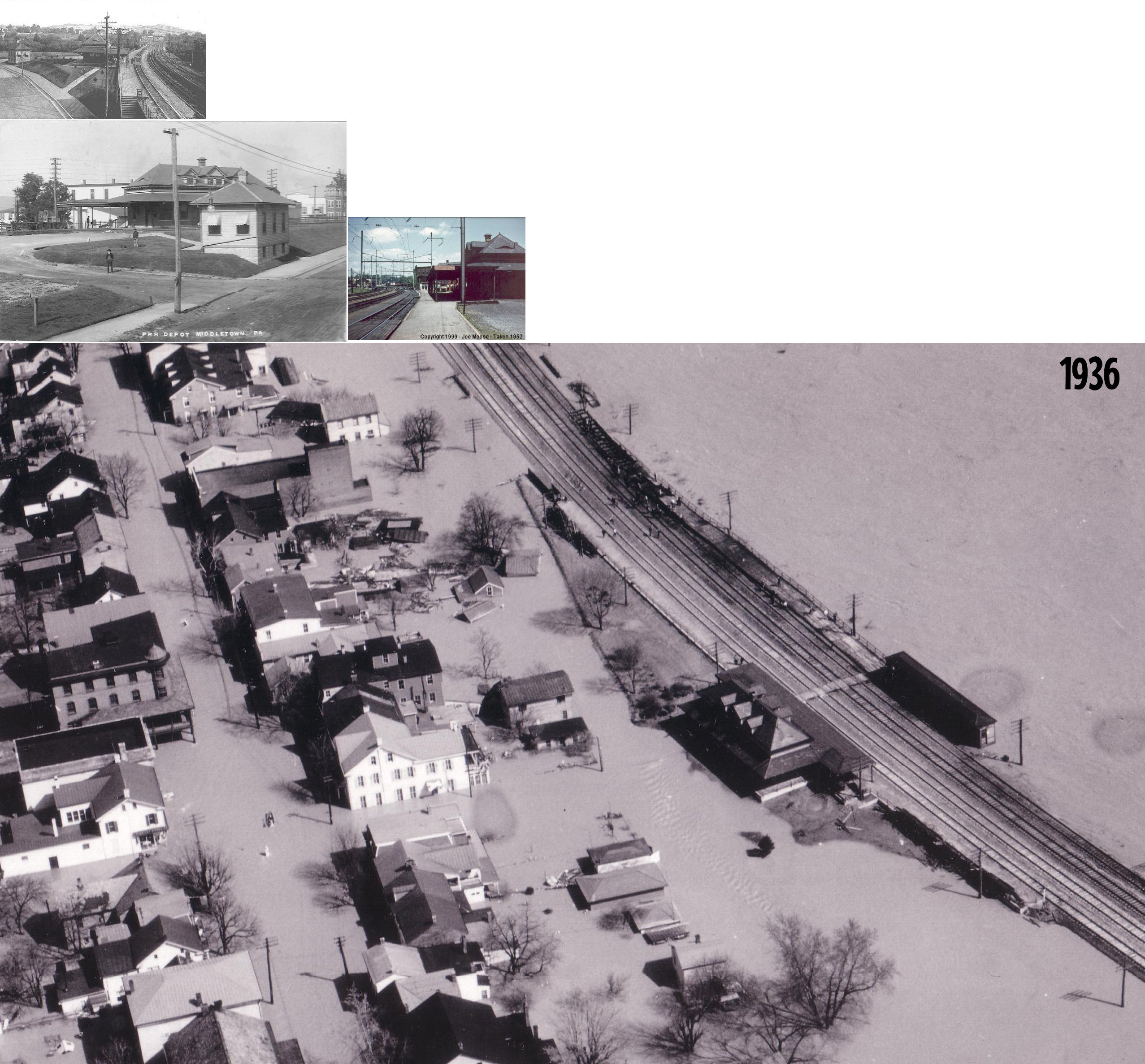
| Highspire |
|
This was the original station that was on the west side of Railroad Street and Front Street (Industrial Avenue) at GPS: 40.207481, -76.790676. The first railroad station in Highspire was located along the original tracks of the Harrisburg, Portsmouth, Mt. Joy and Lancaster Railroad, later the Pennsylvania. It was built in 1871. After the ice jam flood of 1904, the PRR elevated a new set of passenger tracks on an embankment right along the Susquehanna River. The old station then became a freight station. The building was razed after the 1972 flood. The original frieght station was on the east side of Railroad Street at Front Street at GPS: 40.207365, -76.790403. Both of these stations are shown on Sanborn maps as late as 1915. | ||||||
| Highspire |
|
This station was on the south end of Railroad Street along the raised embankment that was built in 1904 for the new passenger tracks. Aerial photos of Highspire from the 1936 flood show that the station was razed before March 1936. | ||||||
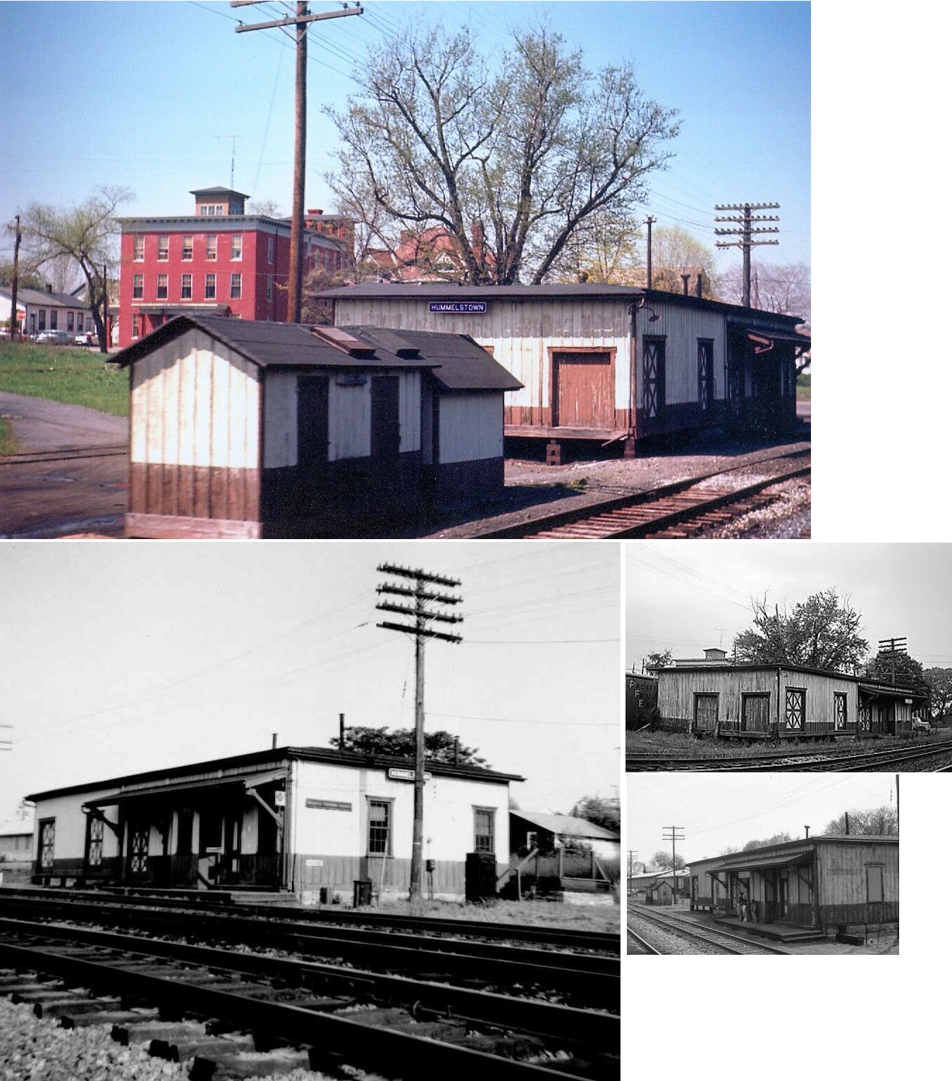
| Hummelstown |
|
This station was on the NE side of Railroad Street on the south side of the tracks at GPS: 40.266905, -76.711973. | ||||||
| Inglenook |
|
|||||||
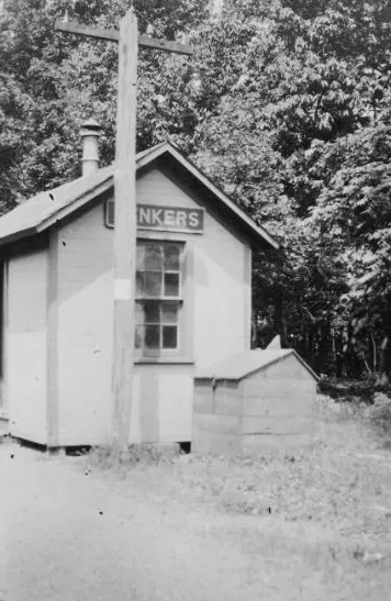
| Lenkers |
|
This station was on the east side of Lenker Station/Mohr Road on the south side of the tracks at approximately GPS: 40.537569, -76.864172. | ||||||
| Liverpool |
|
Although Liverpool is on the west bank of the river, this station was located across the river on the east side and served as a way stop for passengers disembarking for a ferry ride to Liverpool. Tracks down the west side of the Susquehanna between Selinsgrove and Amity Hall were planned twice but never built. The station was west of PA147 on the bank of the river at approximately GPS: 40.567470, -76.978153. | ||||||
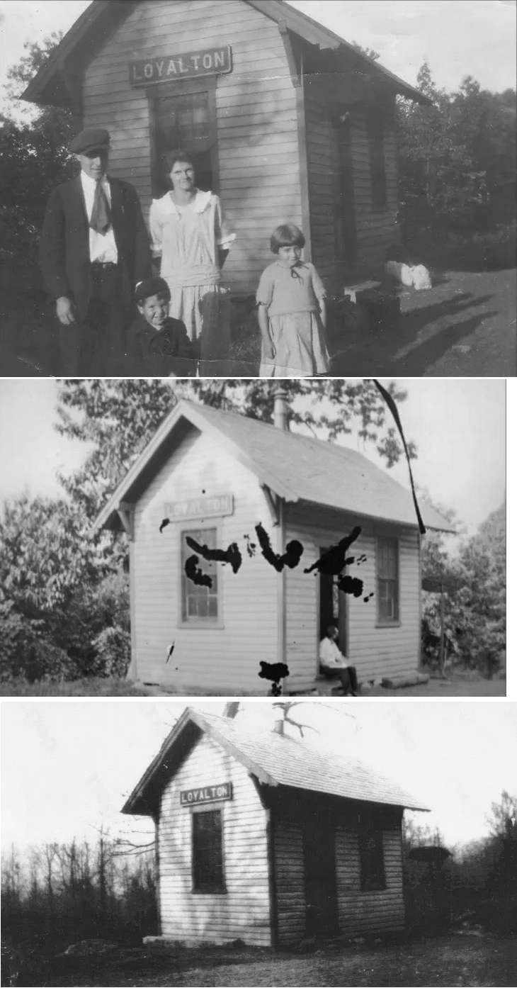
| Loyalton |
|
See listing for Oakdale below. | ||||||
| Lucknow |
|
|||||||
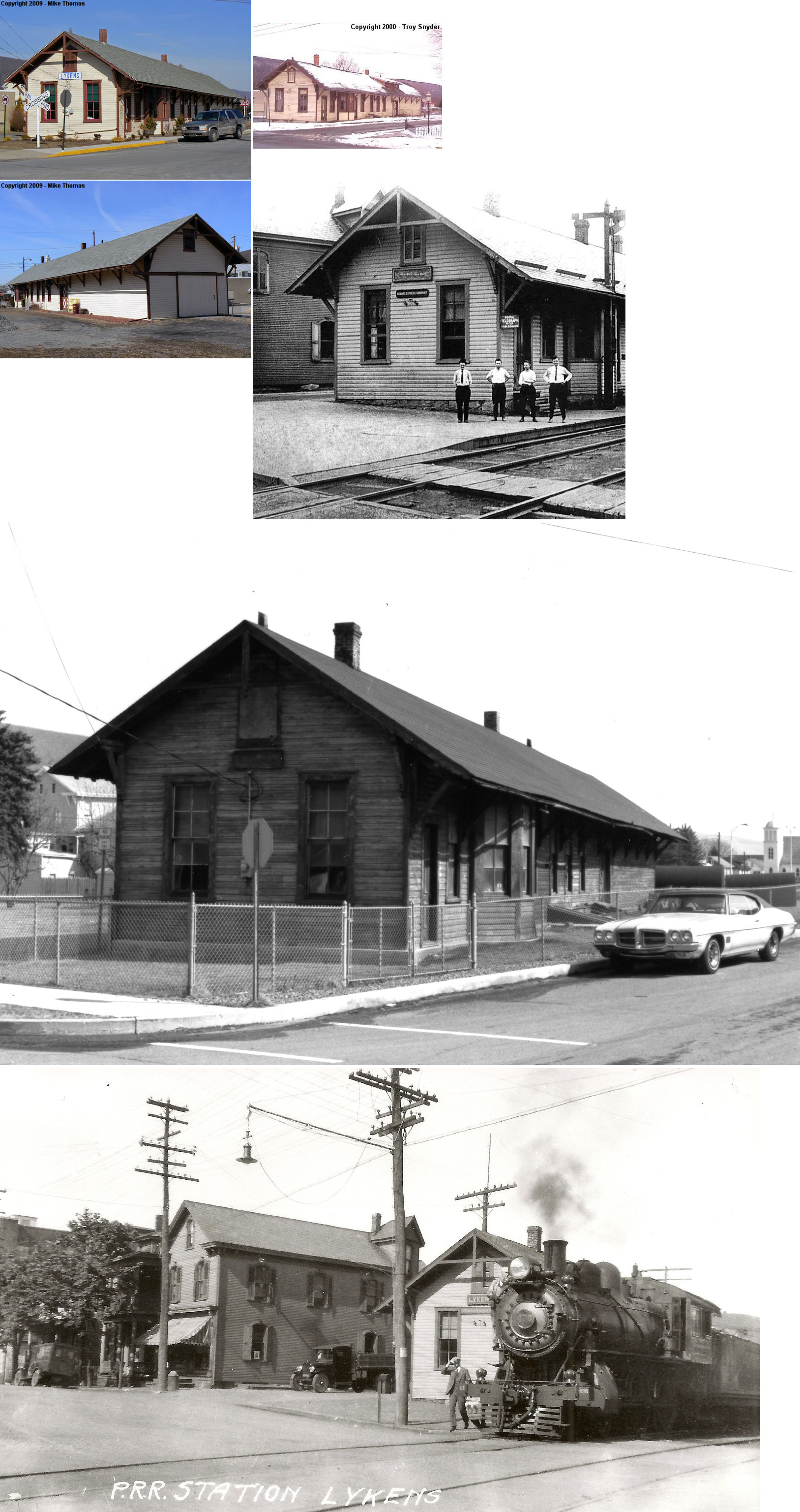
| Lykens |
|
This station was built in 1893. It was a terminal-type station on the east side of Market Street at GPS: 40.569486, -76.700201. | ||||||
| Lykens Valley Junction |
|
In 1859 the original Millersburg station was moved here to serve as a station as Millersburg was to have a new depot open. Not sure if that was replaced by this hotel/station combo. | ||||||
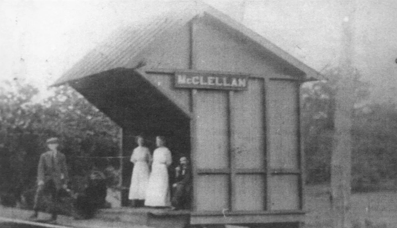
| McClellan |
|
|||||||
| Middletown |
|
This sparse metal station was torn down and replaced with the new station early in 2022. It was on the south side of Mill Street at Poplar Street (GPS: 40.192661, -76.731127). | ||||||
| Middletown |
|
The original passenger station here was a small frame structure at the corner of Union and Wilson Streets at GPS: 40.193294, -76.731957. | ||||||
| Middletown |
|
This station was on the SW side of Mill Street on the NE side of the tracks at GPS: 40.192618, -76.731089. | ||||||
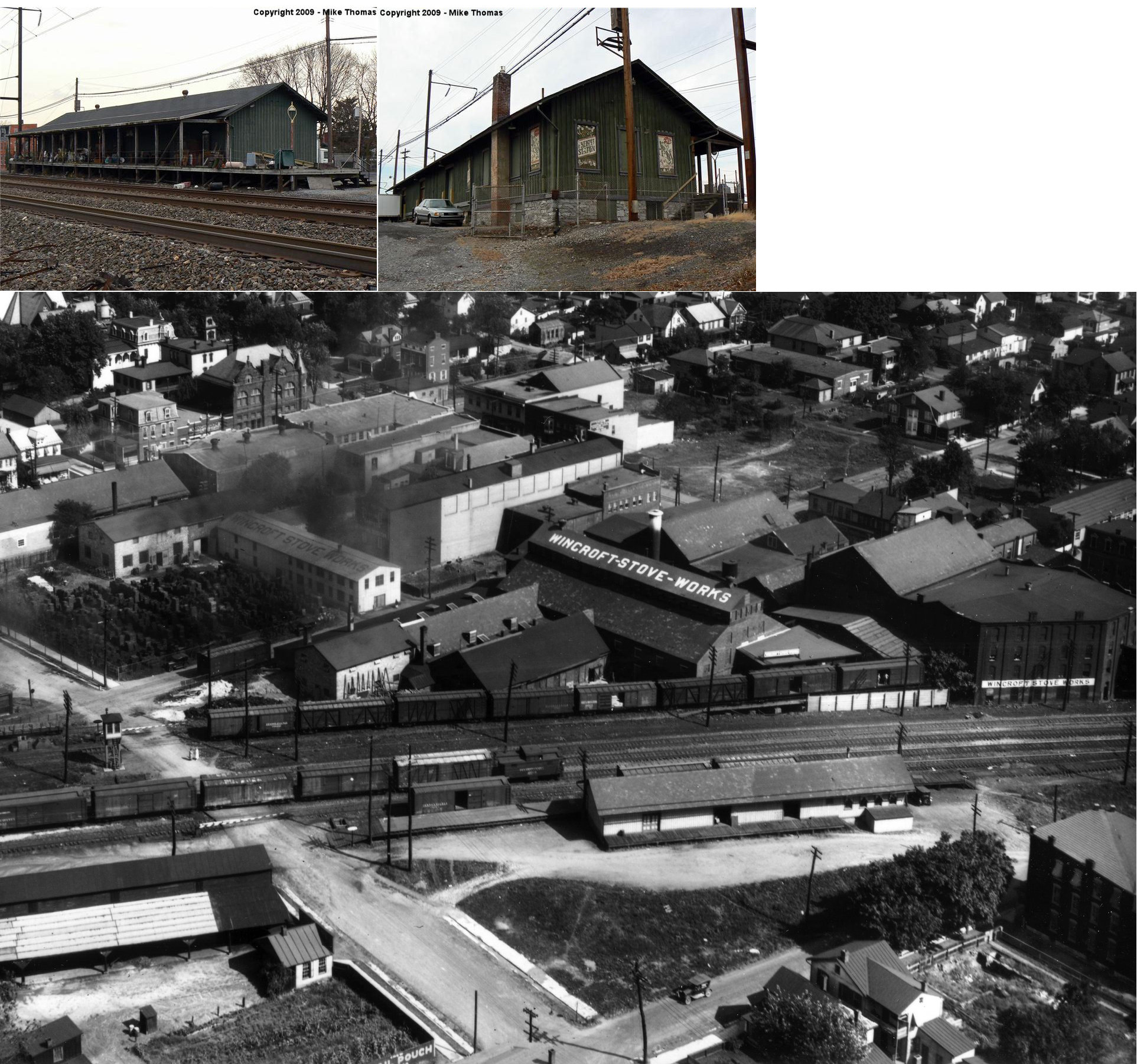
| Middletown |
|
The original freight house was a bit to the NE of the existing freight station at GPS: 40.193751, -76.732380. Originally there were three sets of tracks in front of the original station, but when the number of tracks increased to seven (including sidings) sometime between 1902-1911, a new, slightly longer freight station was built. | ||||||
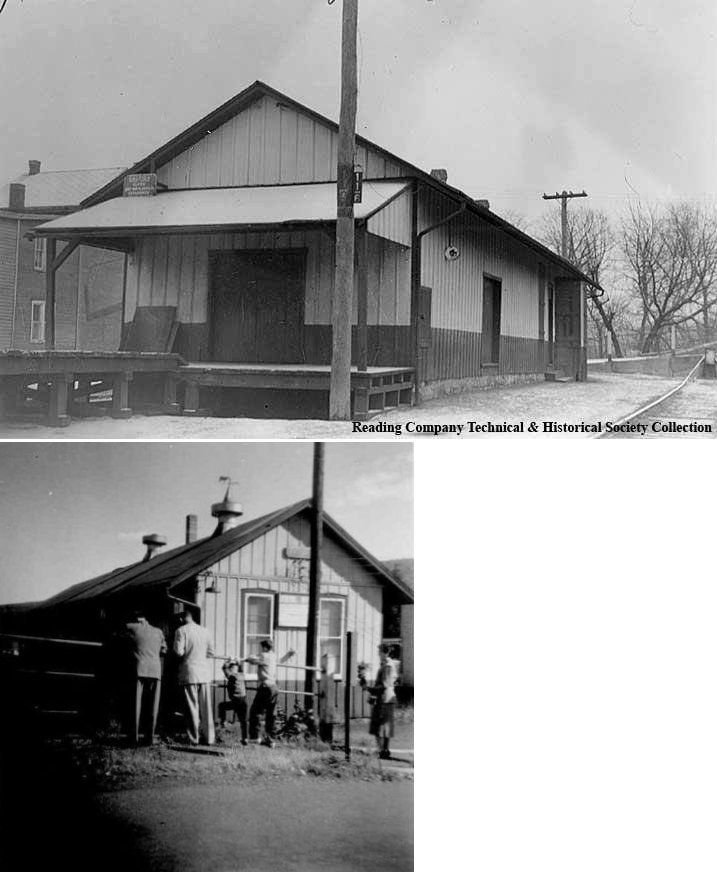
| Middletown |
|
The first Reading station here was established in 1888 and was likely just a waiting room inside the Kline Hotel which was next to the tracks and next to the eventual location of the station built in 1891. An old caboose was used a freight station in the early days until the 1896 freight station (still standing) was erected. | ||||||
| Middletown |
|
This terminal-type stone station was on the east side of Union Street between Mill Street and Brown Street at GPS: 40.193810, -76.731398. It was built in 1891. | ||||||
|
Millersburg (Lenkerville) |
|
The original Millersburg station was a combination hotel/station. | ||||||
| Oakdale (Loyalton) |
|
This station was on the east side of Oakdale Station Road on the north side of the tracks at approximately GPS: 40.556024, -76.759528. | ||||||
| Paxton (Mahantongo) |
|
This station was on the south side of Paxton Drive/River Drive at approximately GPS: 40.595820, -76.938742. A station is shown here on the 1926 map, but not on the 1941 map. | ||||||
| Rattling Run Station |
|
This station was on the Schuylkill & Susquehanna Branch. It was located on the north side of the tracks on the east side of where the tracks cross Rattling Run at GPS: 40.435992, -76.716478. | ||||||
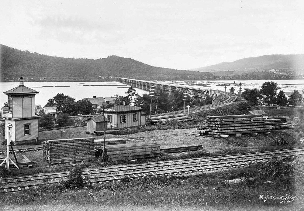
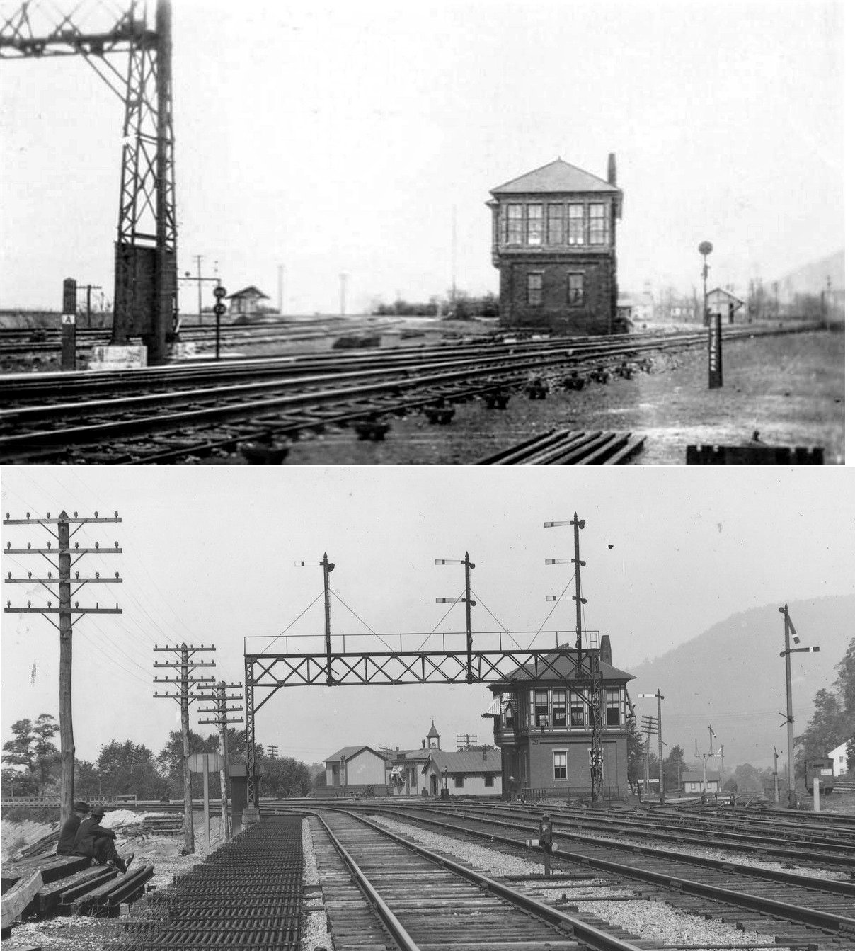
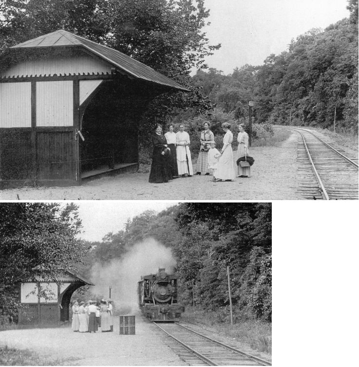
| Rockville |
|
This was the original station and tower here. It was was between US-322 and Tuscarora Lane at approximately GPS: 40.333269, -76.900628. | ||||||
| Rockville |
|
In later years the station listed above was replaced with waiting shelters on both lines where the rails diverge after the bridge (see photo) and a small freight house. A brick tower replaced the old wooden model. | ||||||
| Royalton |
|
|||||||
| Rutherford |
|
|||||||
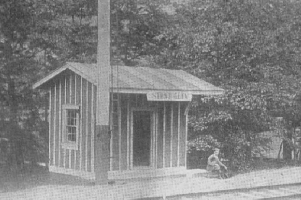
| Singersville |
|
A station is shown here on the 1926 map. It was on the south side of Stony Creek Road around GPS: 40.377869, -76.911235. It is hard to tell where the rail line went though here by looking at Google Earth. Can anyone give a more precise location for the station? According to the 1926 map, the station was just east of where the RR crossed over the creek here with the station on the north side of the tracks, but I can't tell where that was. | ||||||
| Speeceville |
|
|||||||
| Steelton (Baldwin) |
|
A new station was built here in 1867. In 1875, when this location was known as Baldwin, the station was at the end of Locust Street on the north side of the tracks at GPS: 40.230710, -76.843376. This was before the steel mill had grown and when Locust Street went through all the way to the tracks down by the river bank. The station was gone by the early 1880s. | ||||||
| Steelton |
|
The later PR passenger station was south of Christain Street in the vicinity of GPS: 40.233374, -76.848180. A new station was built here in 1887. | ||||||
| Steelton |
|
The freight station was also south of Christain Street near the passenger station in the vicinity of GPS: 40.233374, -76.848180. | ||||||
| Steelton |
|
The passenger station was on Locust Street just south of Front Street on the north side of the tracks at GPS: 40.234268, -76.840940. | ||||||
| Steelton |
|
There was a brick and wood frame freight house on the NW side of Trewick Street at approximately GPS: 40.235482, -76.845039. | ||||||
| Stone Glen |
|
This shelter-type station was on the Schuylkill & Susquehanna Branch. It was on Stone Glen Road in the vicinity of GPS: 40.384719, -76.888980. | ||||||
| Stoverdale |
|
This shelter-type station was just SW of where the tracks cross Swatara Creek at approximately GPS: 40.250380, -76.718704. There are no roads leading to this location today. A station is shown here on the 1941 county map. | ||||||
| Water Tank Station |
|
This station was on the Schuylkill & Susquehanna Branch. It consisted of a caboose with a shed attached. It was between White Spring and Rattling Run. There are no roads in this area today (nor were there on the 1926 map). | ||||||
| Whitehouse |
|
This early station was between Highspire and Middletown in the vicinity of GPS: 40.200175, -76.772831. | ||||||
| White Spring |
|
This station was on the Schuylkill & Susquehanna Branch. It was south of Ellendale Road in the vicinity of GPS: 40.400080, -76.844055 on the north side of the tracks. | ||||||
| Wiconisco |
|
This station was on the Summit/Lykens Branch. | ||||||
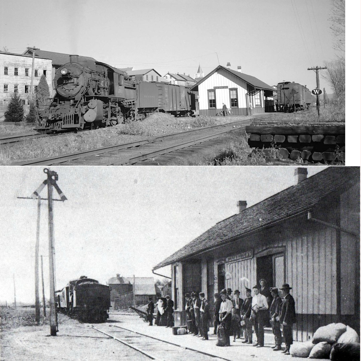
| Williamstown Station |
|
This station was near the end of Colliery/Mountainside Road in the vicinity of GPS: 40.590982, -76.610191. | ||||||
| Williamstown |
|
This station was built in 1893. It was on the east side of South West Street at Station Street at GPS: 40.579055, -76.618980. This is shown on the 1911 Sanborn map. | ||||||
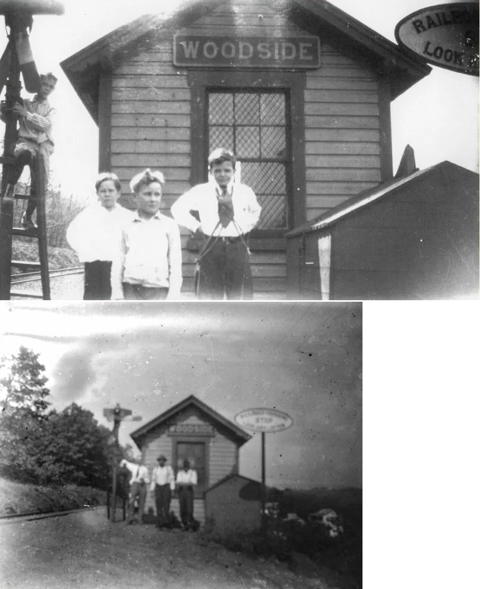
| Woodside |
|
This depot was on the east side of Woodside Station Road on the south side of the tracks at approximately GPS: 40.532202, -76.910003. It was on the PRR's Lykens Branch. Not to be confused with the Woodside RDG station in Montgomery Co. | ||||||
| 1895 DAUPHIN COUNTY RAILROAD MAP | ||||||||
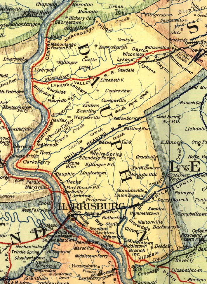 |
||||||||
| Notes About Existing
Stations... Elizabethville (PRR) - Now houses Dauphin County Weatherization. Tracks were torn up in 1976 and the last passenger train was 1958. In 1881 the PRR renamed the station Elizabethville from it original name of Cross Roads Station. The original Lykens Valley Railroad was first constructed around 1834. It was used to haul coal to the Wiconisco Canal in Millersburg, and from there to the Pennsylvania Canal. The PRR owned collieries in Wiconisco in the late 1800's, as did the RDG. The RDG came over the mountains to the east via Pine Grove, Tremont and Tower City - while the PRR used the LVRR to haul the coal from Lykens/Wiconisco and Williamstown to the Northern Central RR in Millersburg, which by this time ran from Harrisburg to Sunbury on the east shore of the Susquehanna River. There are three railroad right of ways on the Broad Mountain from Wiconisco east to Williamstown and on to Tower City. -- Troy Snyder Harrisburg (PRR) - This is the third generation station at this site. Earlier stations were built in 1837 and 1857. This station was built over the course of three years 1885-1887. In 1902, a 60' three-bay, two-story baggage room was added on to the south end as well as a passenger bridge over seight sets of tracks. A 1904 blaze damaged the station and it had to be completely remodeled with 13 rooms added to the west end at that time. In 1911, another 60' three-bay, two-story baggage room was added on to the north end. In 1937, yet another similar addition was added onto the earlier addition on the south end. The basement was remodeled in 1949 for the addition of employee facilities. The train shed nearest the station was built in 1885 and then extended by 120 feet in 1911 making its total length approximately 540 feet. The far shed was built sometime after 1896. Middletown (RDG) - Station built after the Middletown & Hummelstown RR became part of the RDG. |
||||||||