|
|
||||||||
| EXISTING STATIONS | ||||||||
|---|---|---|---|---|---|---|---|---|
| Station Name |
Original Railroad |
Current Location |
Type | Current Use |
Date Built |
Track Status |
Building Material |
More Info |
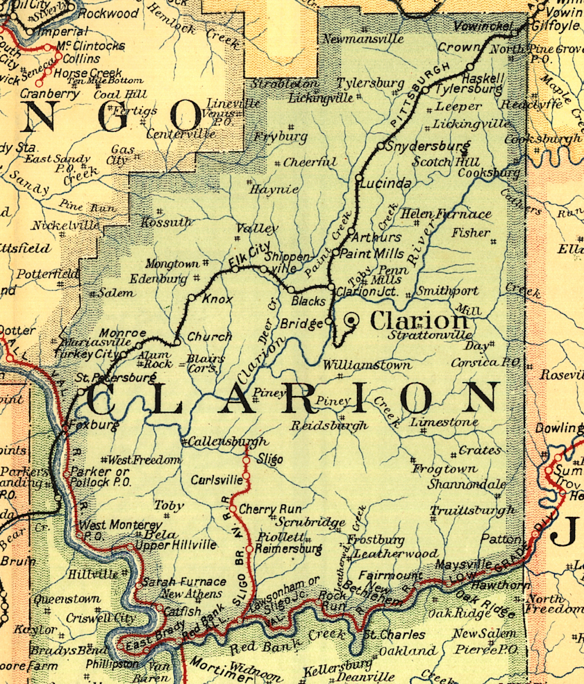
| Knox (Edenburg) |
 |
Corner of Railroad Street and Ohio Street (GPS: 41.236566, -79.535981) |
C | Vacant | ???? | Gone | Wood |
|
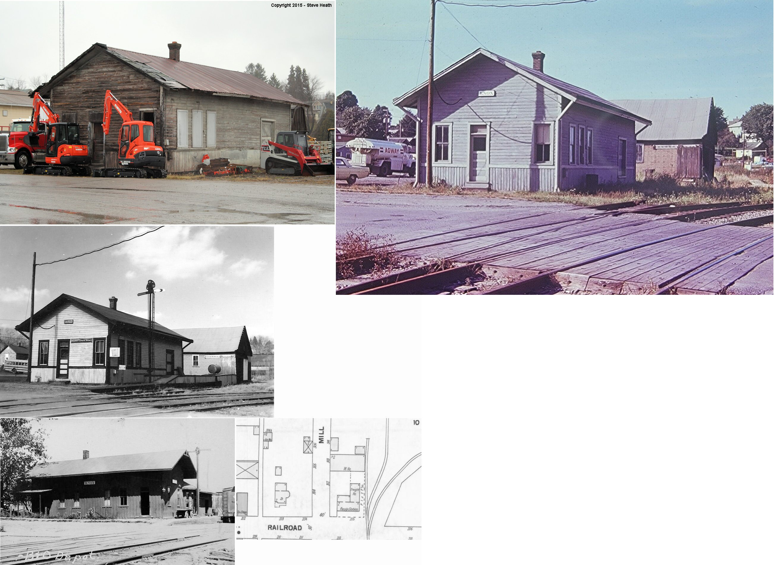
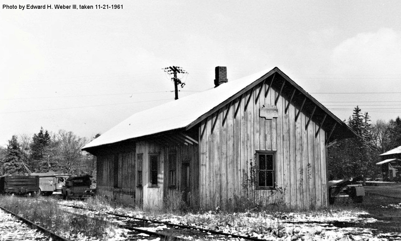
| Lucinda | |
Lander Drive & Walnut Street (GPS:41.313346, -79.369506) |
P | Vacant | ???? | In Use | Wood |
|
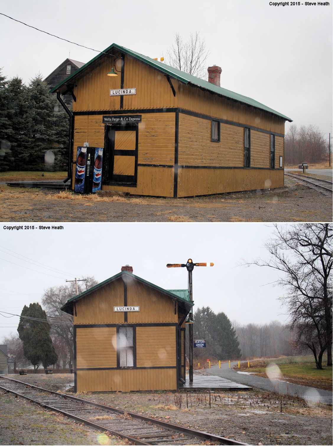
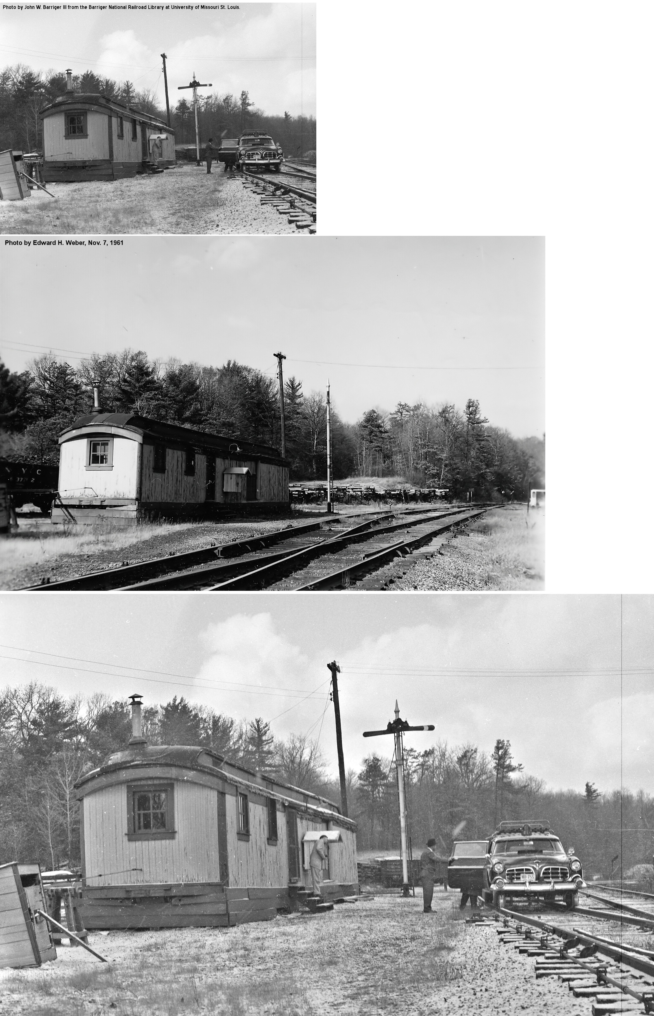
| Sarah Furnace |  |
Sarah Furnace Road | P | Residence | ???? | Gone | Wood |
|
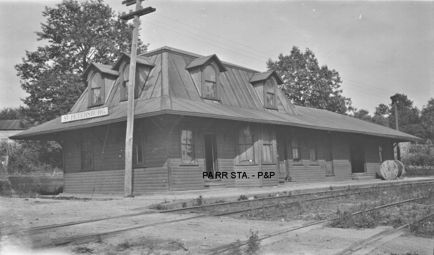
| St. Petersburg |  |
656 Mill Street (GPS: 41.160218, -79.653791) |
F | Residence | 1889 | Gone | Wood |
|
| STATIONS OF THE PAST | ||||||||
| Station Name |
Original Railroad |
Notes | ||||||
| Alum Rock |
|
This station was on the north side of PA58 (Main Street) at approximately GPS: 41.166021, -79.626114. | ||||||
| Anthonys Tunnel Station |
 |
This station was between New Bethlehem and Leatherwood. | ||||||
| Arthurs |
|
This station was at the intersection of Seller Road (TWP-585) and PA66 at approximately GPS: 41.272902, -79.391023. The station here was closed in April 1886 (Clarion Democrat, 4-15-1886). It may have reopened at some point after that. | ||||||
| Bear Creek |
|
|||||||
| Billings |
 |
This station was on the west side of Pine City Road. This is the former Franklin & Clearfield RR line (later LS&MS, later NYC). | ||||||
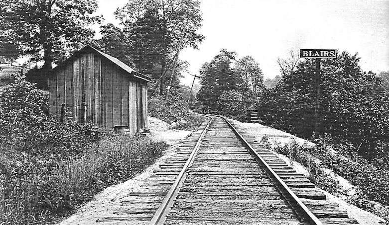
| Blairs Corners |
|
This station was on the north side of PA338 in the vicinity of GPS: 41.181854, -79.561702. | ||||||
| Bridge |
|
See listing below for Clarion (Bridge). | ||||||
| Broken Rock |
|
This station was in Porter Township where Leatherwood Road crosses the grade. Leatherwood Station was the next station to the south. | ||||||
| Bryners Station |
|
This station was on Bryners Mill Road at approximately GPS: 41.237881, -79.454515. | ||||||
| Church Hill |
|
This station is shown on the 1923 PRR List of Stations & Sidings. It was between West Monterey and Parkers Landing. | ||||||
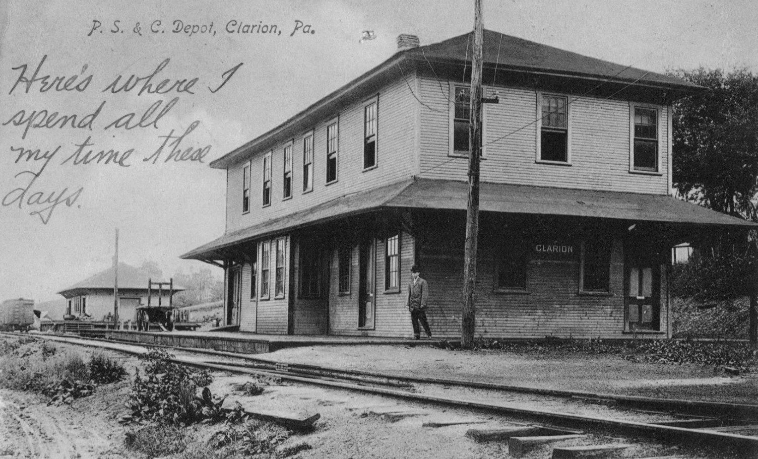
| Clarion |
 |
PS&C = Pittsburgh, Summerville & Clarion RR. The PS&C was a precursor to the Lake Erie, Franklin & Clarion (LEF&C). This was the original wood frame station that was located on the east side of 9th Avenue between Wood Street and Main Street at GPS: 41.211179, -79.378857. There was a freight station to the east. This station burned down on November 8, 1910. | ||||||
| Clarion |
|
This second generation brick station replaced the station listed above and was in the same location. | ||||||
| Clarion |
|
The original P&W station here was at the SE corner of 8th Avenue and Greenville Avenue at GPS: 41.210156, -79.381680. The tracks ended here. It is shown on the 1895 Sanborn map. The tracks and station at this location were removed around 1900. The first station here was built on the Emlenton & Shippenville narrow-gauge line in 1877. That depot measured 90'x20'. | ||||||
| Clarion (Bridge) |
|
|||||||
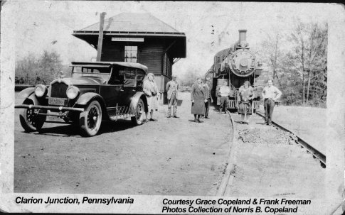
| Clarion junction | |
Before the station listed below was built, an old car body served as the station here. It burned down on January 17, 1914 (Clarion Democrat, 1-29-1914). | ||||||
| Clarion Junction | |
This station was SW of US-322 at approximately GPS: 41.236207, -79.419433. | ||||||
| Climax |
|
|||||||
| Crown | |
This station was on the SE side of what is now Haggerty Drive. | ||||||
| Diamond |
|
This station was on the Sligo Branch which went from lawsonham to Sligo. | ||||||
| Dix Station |
|
This station was in the middle of State Game Lands No. 63 along Deer Creek at approximately GPS: 41.220104, -79.456661. | ||||||
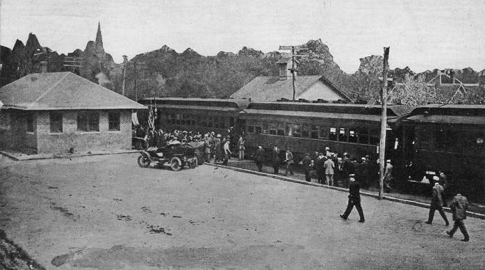
| East Brady |
|
This combination station was at the NE end of Water Street where the grocery store and restaurant now stand at approximately GPS: 40.989777, -79.611599. In 1916 the towns of East Brady and Phillipston were bypassed due to the construction of the Brady Tunnel. Thereafter that art of the line became the East Brady Branch. | ||||||
| Elk City |
|
|||||||
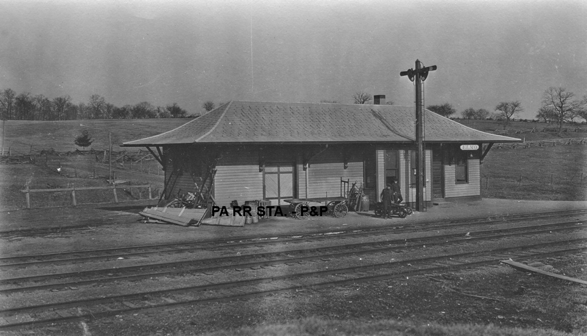
| Elmo |
|
This station was on the north side of US-322 SE of Fern Road at approximately GPS: 41.276259, -79.541005. According to NYC valuation records, a 17'x59' combination station was built here in 1909. | ||||||
| Elss Station |
 |
This station was between Strattanville and Clarion where the line runs next to US-322. This station is shown on the 1941 county map. | ||||||
| Fairmount |
|
|||||||
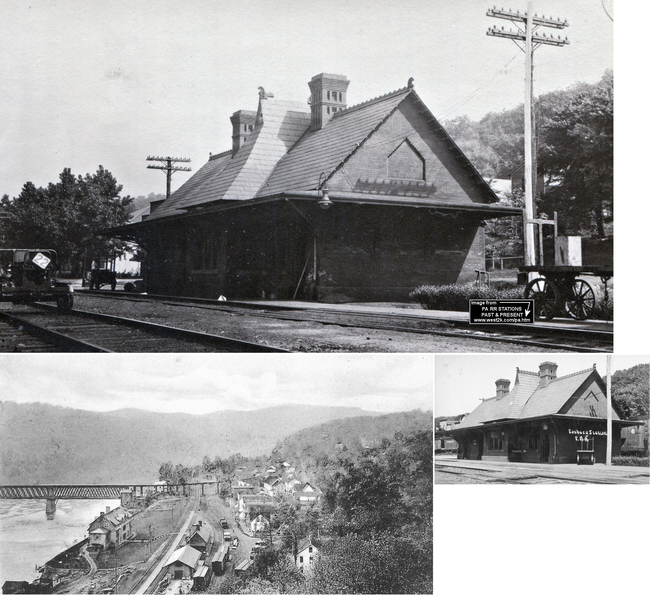
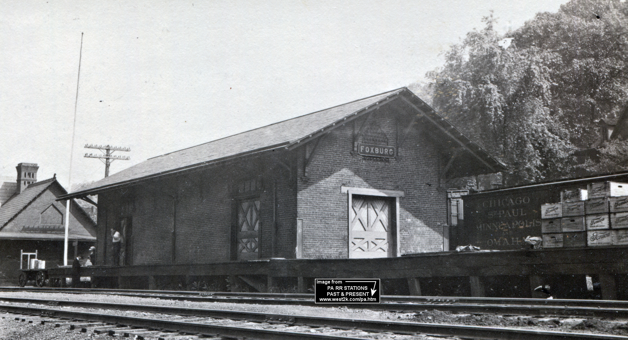
| Foxburg |
|
The original AVRR combination station was located between South Palmer Avenue and what is now Main Street (where the tracks used to be). It burned down in 1884. | ||||||
| Foxburg |
|
Built in 1885 by the Allegheny Valley, replacing the station that burnt down the previous year. The road officially became a part of the Buffalo and Allegheny Division of the PRR in 1910. Passenger traffic on the line through Foxburg ceased 1950-51, and station was demolished by the spring of 1952. The station survived catching fire multiple times during a large blaze in April 1900 that consumed most businesses between the railroad tracks and the river. Railroad employees and volunteers were credited with saving the station (Clarion Democrat 4-26-1900). | ||||||
| Foxburg |
|
This freight station was likely built in 1885 at the same time as the passenger station as the unique brick work is the same on both structures. | ||||||
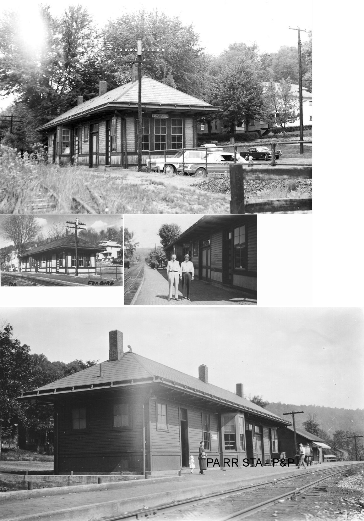
| Foxburg | |
This earlier station was built in 1883, but destroyed by fire in 1915 (Kane Republican, 5-28-15). | ||||||
| Foxburg |
|
This station, built to replace the one that burned in 1915, was destroyed by fire on May 16,1975 (Oil City Derrick, 5-17-1975). It was on North Palmer Avenue. No trains on the B&O had gone through Foxburg after 1964, line was removed in 1982. The depot was built on the site of the Smith Building which hosted the first church services in Foxburg before the denominations built their own church buildings (Clarion Democrat, 8-23-1917). | ||||||
| Gardner |
|
See listing below for Huey. | ||||||
| Gordontown |
|
This station was on the west side of Pioneer Road at approximately GPS: 41.185666, -79.305659. | ||||||
| Hamler |
|
This station was on the Sligo Branch 1.6 miles north of Rimersburg station. | ||||||
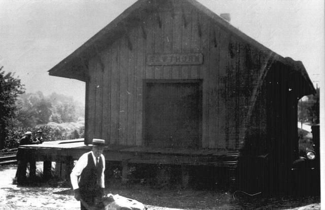
| Hawthorn |
|
This station was near the junction of the Pine Run Coal Company RR. | ||||||
| Heidrick Station |
|
This station was near the county line on Holden Road at approximately GPS: 41.153883, -79.214105. It was only a short distance from the NYC's Sutton Station. | ||||||
| Helper |
|
This station was 1.3 miles from the Oak Ridge station and 1.3 miles from the New Bethlehem station. A station is listed here on the 1923 PRR List of Stations & Sidings. | ||||||
| Henderson |
|
This station was on the east side of Kingsville Road at approximately GPS: 41.173620, -79.277472. | ||||||
| Hillville (Upper Hillville) |
|
The 1923 PRR List of Stations & Sidings lists stations for both Upper Hillville (milepost 40.8) and Lower Hillville (milepost 39.3). | ||||||
| Hillville (Lower Hillville) |
|
|||||||
| Holden |
|
This station was on the NW side of Olean Trail (TWP-2005) at approximately GPS: 41.166689, -79.223723. | ||||||
| Huey (Cherry Run) (Gardner) |
|
The station was on the north side of Huey Road at approximately GPS: 41.081160, -79.507915. The 1923 PRR List of Stations & Sidings lists only a freight station here under the name "Gardner." | ||||||
| Jefferson Station |
|
This station was on the north side of Jefferson Furnace Road at approximately GPS: 41.202721, -79.563584. | ||||||
| Jocelyn |
|
This station is listed on the 1923 PRR List of Stations & Sidings. It was on the Sligo Branch, two miles south of the station at Sligo. | ||||||
| Kingsville |
|
This station was on the SE side of Olean Trail (CR-2005) at approximately GPS: 41.130257, -79.266146. According to NYC valuation records, a 12'x12' passenger station was built here in 1914. | ||||||
| Kingsville |
|
According to NYC valuation records of 1919, "the freight house is property of the citizens of Kingsville" and was leased by the railroad. | ||||||
| Kline Station |
|
This station was on the west side of Kline Road at approximately GPS: 41.298473, -79.585011. Also spelled "Cline" on some timetables. According to NYC valuation records, a small 6'x12' passenger shelter was built here in 1912. | ||||||
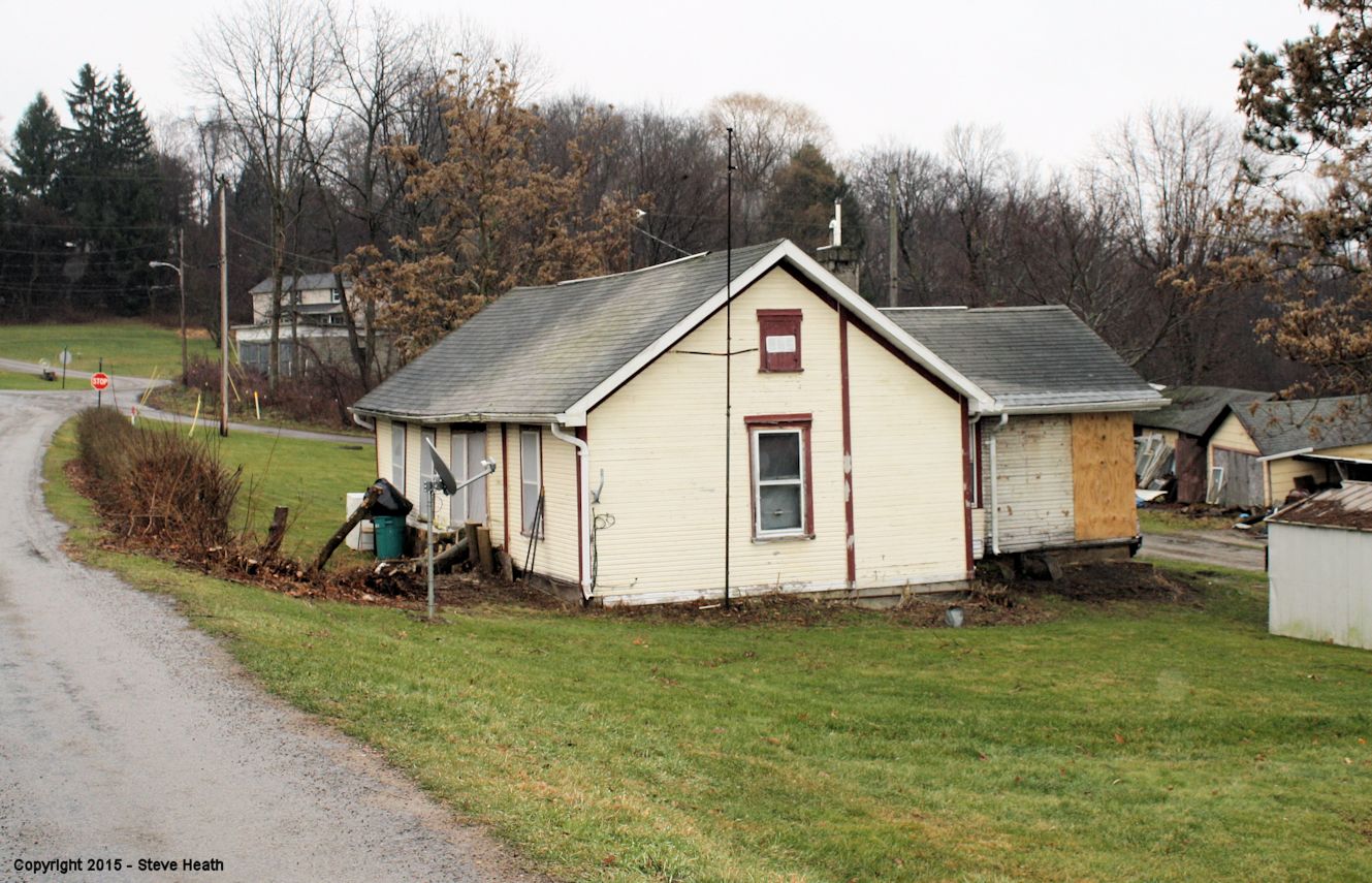
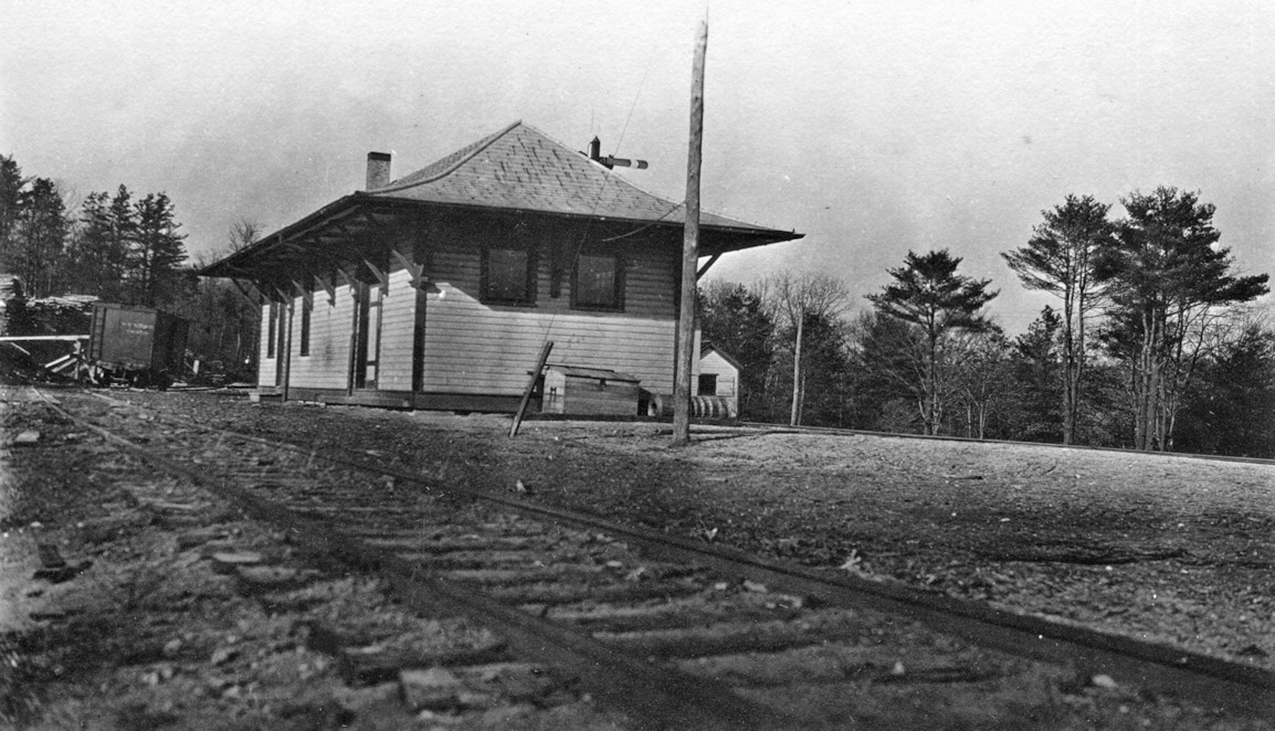
| Knox (Edenburg) |
 |
In 1877 there was a Emlenton, Shippenville & Clarion station on the northeast corner of Ohio and East Railroad Streets. It was at the end of a short spur line. (GPS:41.236435,-79.536145) | ||||||
| Knox (Edenburg) |
|
This station was at the corner of Railroad Street and Ohio Street (GPS: 41.236566, -79.535981).The tracks were abandoned in 1987 and removed in 2001. Local historical society initially attempted to gain ownership of station for restoration, but station was ultimately demolished in February 2023. Knox was formerly known as Edenburg. It appears from the photos that only the freight part of the original station remained. In the old days, the station had a dwelling attached to the rear as well, presumably for the station agent. | ||||||
| Lawsonham |
|
The first station was located at GPS: 40.995897,-79.490021. I suspect the second station listed below was as well. According the 1877 county map there was also a section house just north of the station. Prior to 1883 this station was known as Sligo Junction. | ||||||
| Lawsonham | |
There was a passenger and freight station here. | ||||||
| Leatherwood Station |
|
This station was in Porter Township near where Leatherwood Creek empties into the Allegheny. | ||||||
| Leeper (Tylersburg Sta.) |
|
Station was at PA36 and Railroad Street. | ||||||
| Limestone |
|
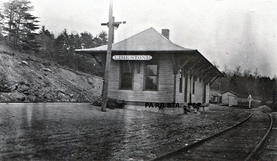
This station was on the SE side of PA66 at approximately GPS: 41.129359, -79.325915. According to NYC valuation records, a 17'x59' combination station was built here in 1912 after the previous station was destroyed by a fire started by lightning in June 1911 (Clarion Democrat 6-15-1911). | ||||||
| Little Toby Station | |
This station was in the vicinity of GPS: 41.354047, -79.321511. | ||||||
| MAysville (Mayport) |
|
The 1877 map shows a freight station here, but no passenger station. That may have just been an omission on the map as it also shows a railroad office and hotel nearby. Also known as "New Mayville" at one time. The 1941 map shows the station on the SW side of Mayport Road at approximately GPS: 41.033541, -79.251165. | ||||||
| Mill creek Station |
|
This was the terminus of the old Mill Creek Branch that ran north out of Strattanville. The station was just south of where Mill Creek empties into the Clarion River and was a hub for logging. This station is shown on the 1912 map, but not on the 1941 map as the line was gone by then. | ||||||
| Millville |
|
|||||||
| Monroe (Monroeville) |
|
Before the line was moved, the Emlenton, Shippenville & Clarion RR went through Monroe in Beaver Twp. According to the 1877 map, the station was on the north side of what is now PA 338 and Monroe Church Road. The station was on the east side of the tracks. | ||||||
| Monterey |
|
See listings below for West Monterey. | ||||||
| Mortimer |
|
There are no roads in this area now, but the station was located around GPS: 40.980934, -79.534324. It is only accessible from the Redbank Valley Trail now. There is a stream that feeds into Redbank Creek here. Does anyone know the name of that stream (Mortimer perhaps)? A station is listed here in the 1923 PRR List of Stations & Sidings. | ||||||
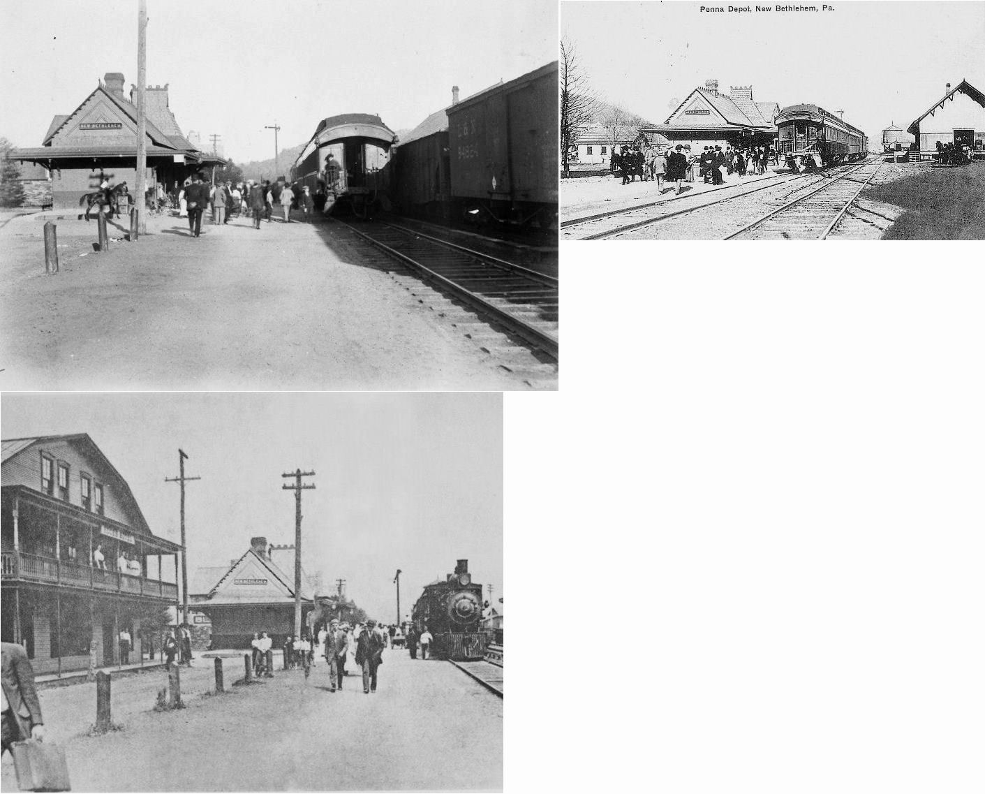
| New Bethlehem |
|
In 1877 the station here was between Wood and Vine Streets on the south side of the tracks at GPS: 41.002366, -79.330370. A new wood passenger station was built on the north side of the tracks at GPS: 41.002540, -79.330370, and the original station on the south side was then used as a freight station (as seen on the 1894 map). | ||||||
| New Bethlehem | |
A new brick passenger station was constructed in the same location as the second generation passenger station listed above (at GPS: 41.002540, -79.330370). The original Allegheny Valley RR station may be the freight station on the right in the one photo that shows both stations. This station underwent a complete interior remodeling in 1925. | ||||||
| Oak Ridge Station |
|
|||||||
| Paint Mills Station | |
This station was at the intersection of Paint Mills Road and PA66 at approximately GPS: 41.252078, -79.408929. | ||||||
|
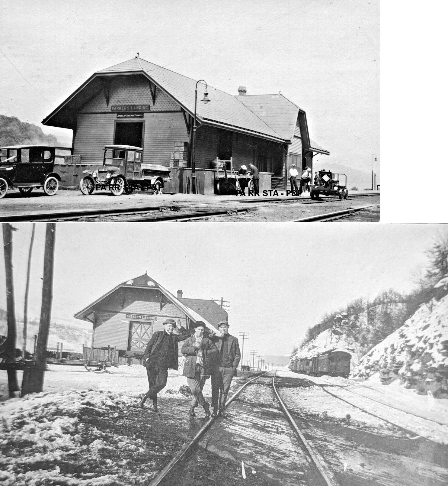
Parker's Landing (Pollock) |
|
Also known as Parkers Station and East Parker. The original station was just north of where the old Parker & Karns City RR bridge crossed the river. According to the 1941 map, the station was beneath the PA368 bridge on the south side at approximately GPS: 41.101742, -79.677648. The 1912 map shows the station on the north side of the bridge. These maps are not exact though. The 1898 Sanborn map shows the station on the west side of Central Avenue at 4th Street. | ||||||
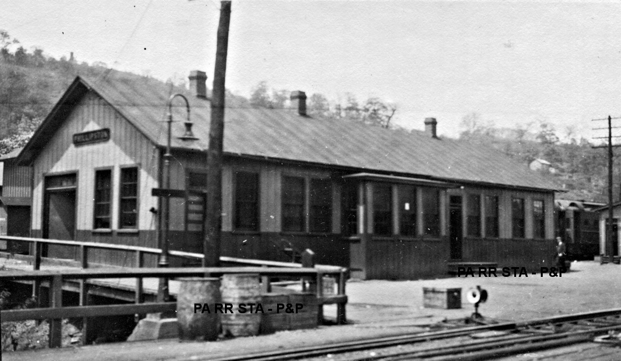
| Phillipston |
|
Formerly called Phillipsburg. The 1877 county map shows a station here at the end of what is now Phillipston Road (formerly Walnut Street) at the Armstrong Trail. The station was on the west side of the tracks on the north side of the street (GPS: 40.973807,-79.590041). | ||||||
| Pickwick |
|
Pickwick was an early station on the narrow gauge Emlention & Shippensville RR. The first station here was built in 1877. | ||||||
| Rader |
|
This station was ont he west side of Smith Road at approximately GPS: 41.168676, -79.256380. | ||||||
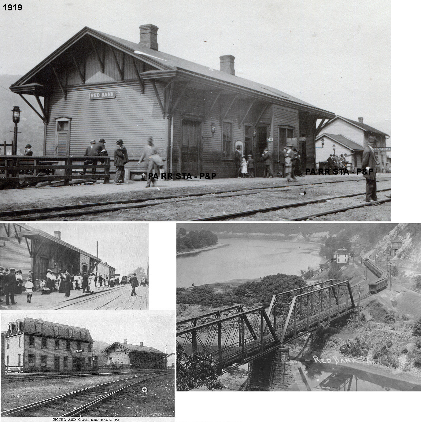
| Red Bank |
|
The first station here burned down in 1879. | ||||||
| Red Bank | |
This station was built in 1880 after the previous station burned down. Red Bank was a junction point on the Buffalo & Allegheny Valley Division with the Low Grade branch meeting the two track mainline at the mouth of Red Bank Creek. This station also burned down in March, 1902. | ||||||
| Red Bank | |
This station, built at the same site as the station listed above, subsequently burned down in 1945. | ||||||
| Red Bank | |
This brick station was built after the older station burned in 1945. | ||||||
| Red Bank (S. Red Bank) |
|
The 1923 PRR List of Stations & Sidings lists a freight station for South Red Bank about 1/3 mile from the Red Bank passenger station. | ||||||
| Red Bank Furnace |
|
There was a station here indicated on the 1877 county map. It also shows a "floating hotel" here on the river. | ||||||
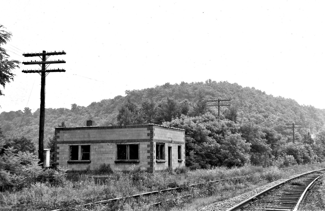
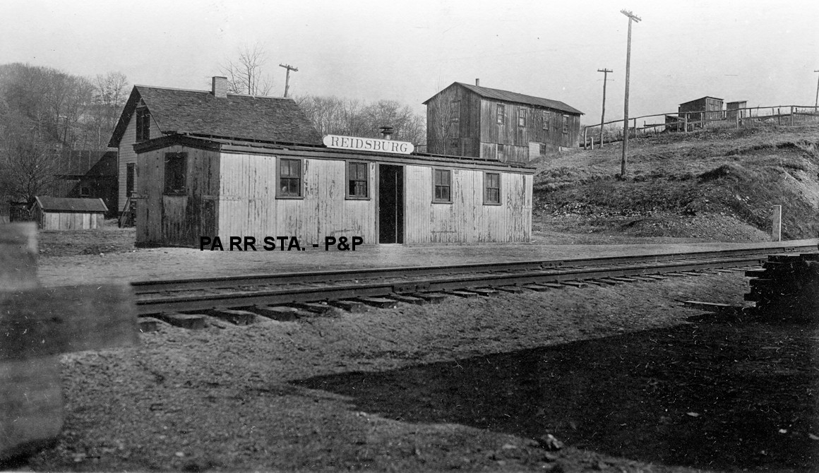
| Reidsburg |
|
This station was on the east side of PA68 at approximately GPS: 41.150708, -79.403385. According to NYC valuation records, a 9'x34' carbody was placed here in 1909 to serve as a combination station. | ||||||
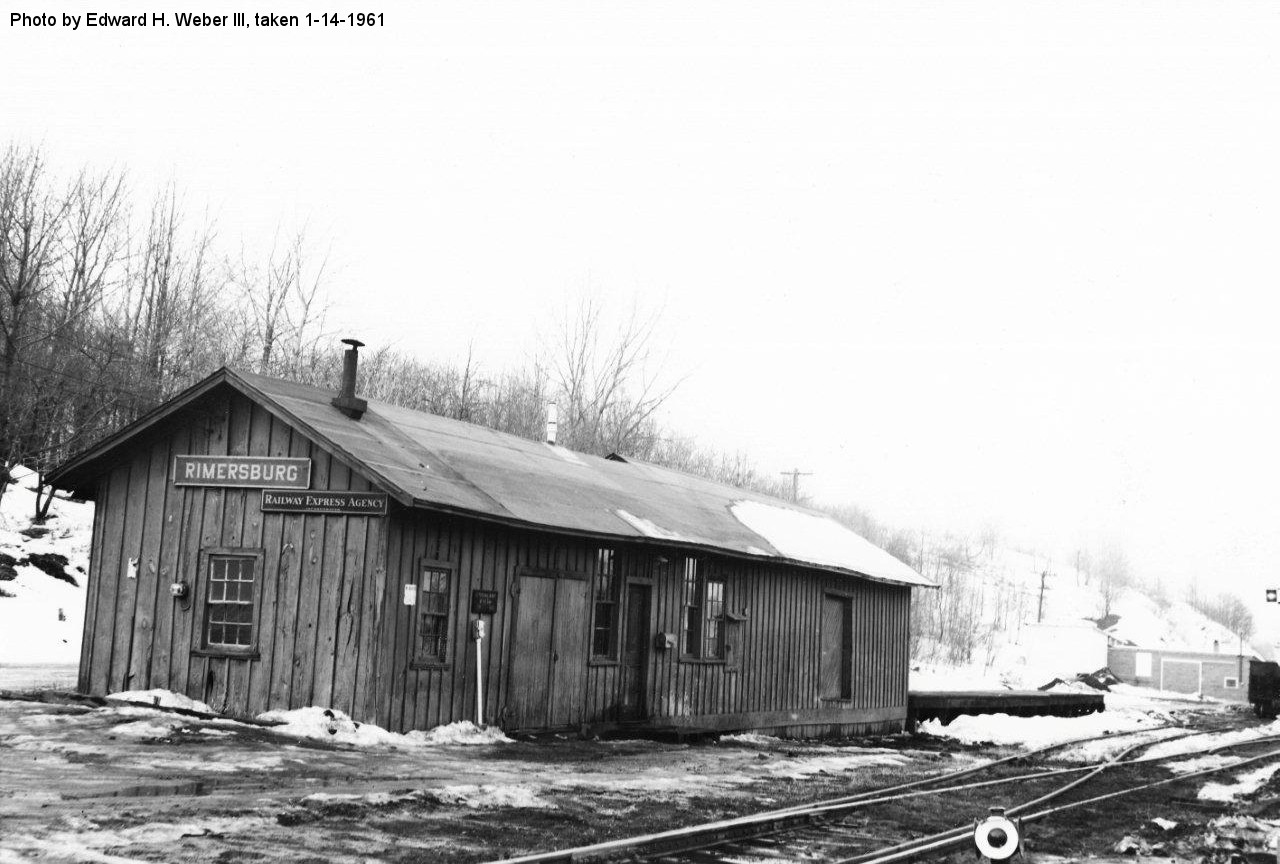
| RimersburG Station |
|
Removed in the 1970s. Rimersburg station was originally called Centre City and there was a station here as early at the 1870s. This station was on the west side of PA68 on the SW side of the tracks at GPS: 41.052194, -79.494754. | ||||||
| Ritt's Farm | |
This station was on the north corner of Ritts Station Road and Ritts Farm Road at approximately GPS: 41.173470, -79.588568. | ||||||
| Rock Run Station |
|
This station was in Porter Township near where Rock Run empties into the Allegheny River. There was also a sawmill there in the 1870s. Nothing remains there today and the area is not accessible by road. Only a siding is listed here on the 1923 PRR List of Stations & Sidings, so the station was likely gone by then. | ||||||
| Shannon Station |
|
This station was in the vicinity of the end of Swartz Road at around GPS: 40.980693, -79.504969. | ||||||
| Shippenville |
|
This station was on the west side of PA208 at approximately GPS: 41.247119, -79.467003. The first station here was built on the Emlenton & Shippenville narrow-gauge line in 1877. | ||||||
| Shippenville |
|
This station was on east side of Station Road at approximately GPS: 41.260903, -79.476106. According to NYC valuation records, a 17'x59' combination station was built here in 1909 by the Franklin & Clearfield RR. A station is shown here on the 1941 county map, although the station here burned down on April 26, 1935 (Altoona Tribune, 4-27-1935). After that the railroad placed a converted carbody here as a station. A station stop here was still shown on the 1941 map. | ||||||
| Shippenville |
|
This is the converted carbody that served from 1935 until the end of passenger service. | ||||||
| Sligo |
|
This station was built in 1878 and removed in the 1970s. The first station here was on the west side of Shorb Street. The Miller Colliery, which was .4 miles from the station, was the end of the Sligo Branch. | ||||||
| Snydersburg |
|
This station was on the south side of CR-1008 (GPS: 41.331147, -79.354737). | ||||||
| St. Charles |
|
A station is listed here on the 1923 PRR List of Stations & Sidings, but it is noted as being less-than-carload freight only. | ||||||
| St. Petersburg |
|
The first station here was a Foxburg, St. Petersbugh & Clarion RR depot. It was near the intersection of Grove Street and Salem Avenue. The 1941 map shows the station on the east side of Railroad street. | ||||||
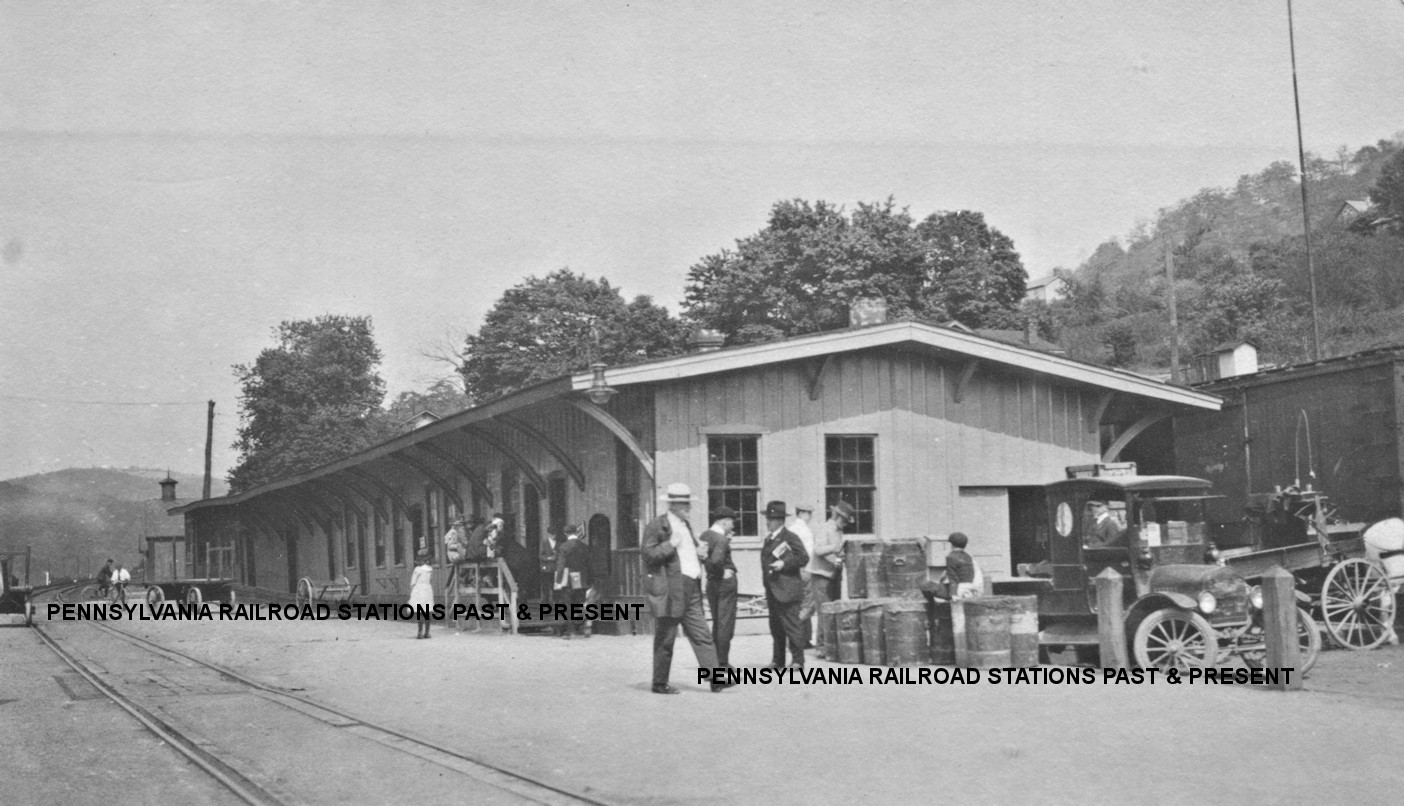
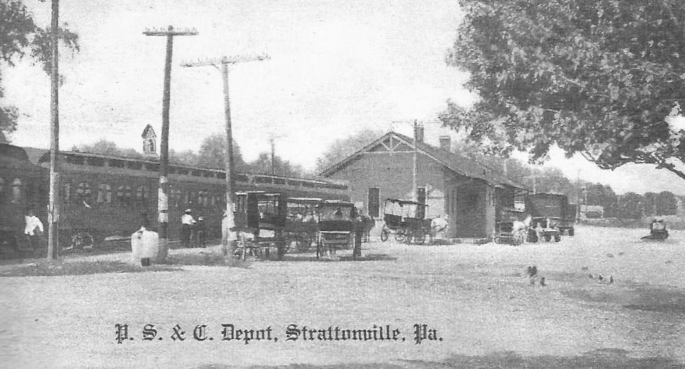
| Strattanville |
|
This station was on Railroad Street. The station burned down on November 7, 1930 (Oil City Derrick, 11-10-1930). | ||||||
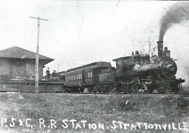
| Strattanville |
|
This photo might show the second (replacement) station here or a freight station. | ||||||
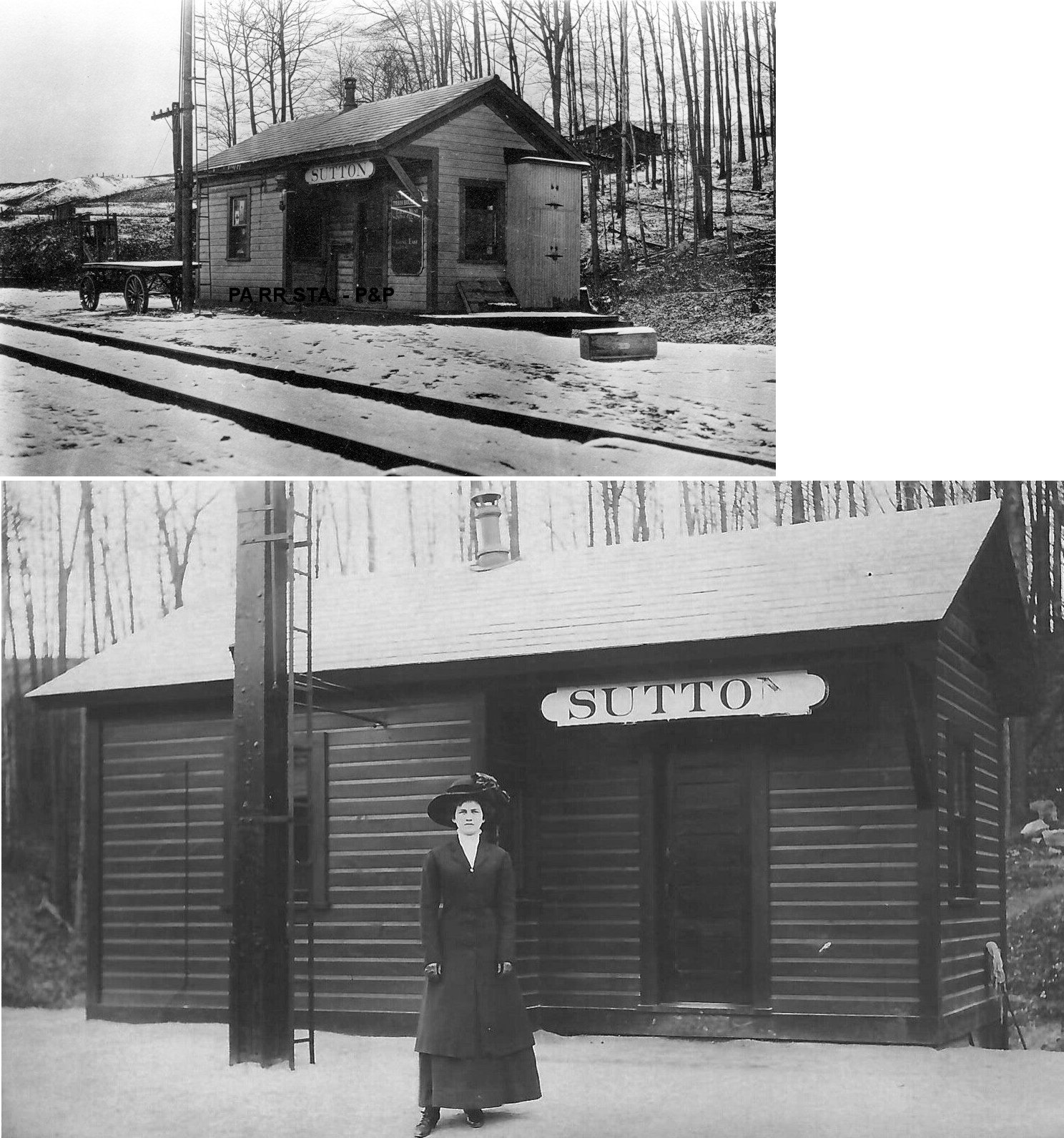
| Sutton Station |
|
This station was near the county line between Holden Road and TWP-811 at approximately GPS: 41.150713, -79.213837. According to NYC valuation records, a 12'x22' combination station was built here in 1909. There were several other railroad buildings here as well. | ||||||
| Turkey City |
|
The 1877 county map shows a station here as does the 1941 map. It was located on the east side of PA338 near the bend at approximately GPS: 41.184324, -79.612770. | ||||||
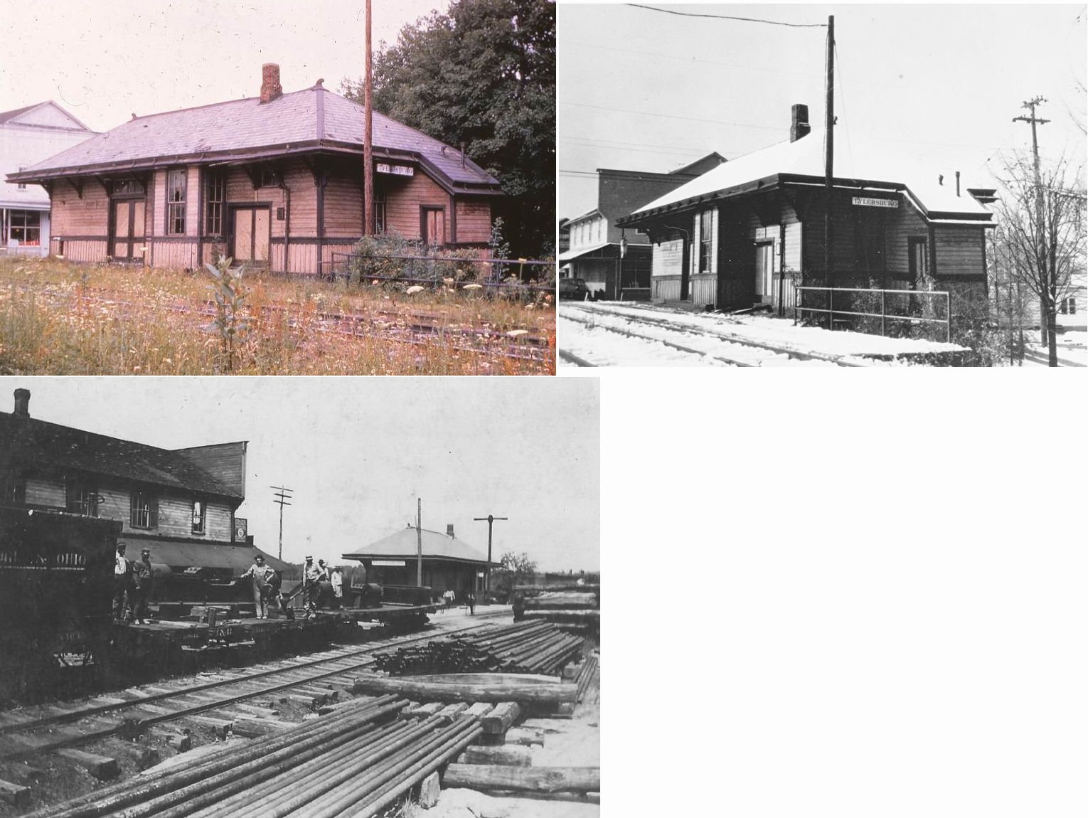
| Tylersburg |
|
This station was on the north side of Arnold Avenue. | ||||||
| Unknown (SAlem TWP.) |
|
According to the 1877 county map, there was an Emlenton, Shippenville & Clarion RR station on Brick Church Road. The map gives no name to this location and it has no specific place name today. The station was located at approximately GPS: 41.206378,-79.642854. | ||||||
| Upper Hillville |
|
The station was on the NE side of town at approximately GPS: 41.038180, -79.608359. There may have been a station at Lower Hillville as well. | ||||||
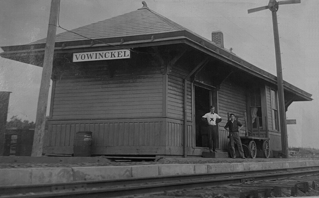
| Vowinckel |
|
This station was on the NE side of McDonald Drive according to the 1941 county map. | ||||||
| Waterson (Showers) |
|
This station was on the north side of Waterson Road at approximately GPS: 41.177531, -79.291431. | ||||||
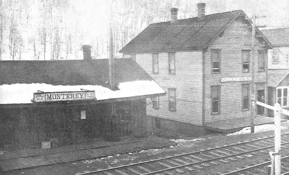
| West Monterey |
|
The first or second station here burned down on January 30, 1899. The fire started at the Valley House Hotel next door then spread to the depot and another building (Clarion Democrat, 2-2-1899). | ||||||
| wEST mONTEREY |
|
This station was built soon after the previous station burned down in 1899 (see above). The 1912 map shows the station at the north end of town. | ||||||
| 1895 CLARION COUNTY RAILROAD MAP | ||||||||
 |
||||||||
| Notes About Existing
Stations... Lucinda (B&O) - Vacant, but restored. Sarah Furnace (PRR) - Building used as station after previous station burned. St. Petersburg (P&W) - Tracks were removed in 1982. This part of the same line that serviced Knox. |
||||||||