|
|
||||||||
| EXISTING STATIONS | ||||||||
|---|---|---|---|---|---|---|---|---|
| Station Name |
Original Railroad |
Current Location |
Type | Current Use |
Date Built |
Track Status |
Building Material |
More Info |
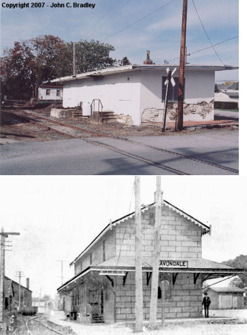
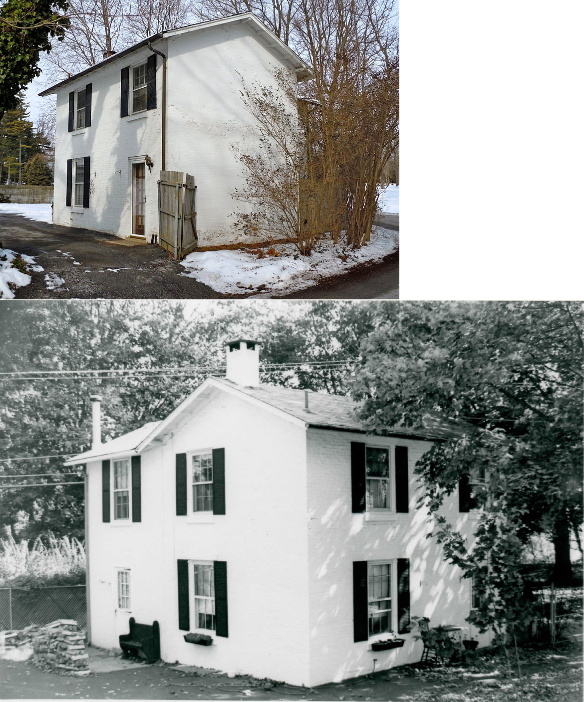
| Avondale |
 |
State Street and Pomeroy Avenue (GPS: 39.824300, -75.784232) |
P | Residence | 1869 | In Use | Stucco |
|
| Avondale |
 |
Pomeroy Avenue NW of State Street (GPS: 39.824751, -75.784667) |
F | Railroad | ???? | In Use | Wood | |
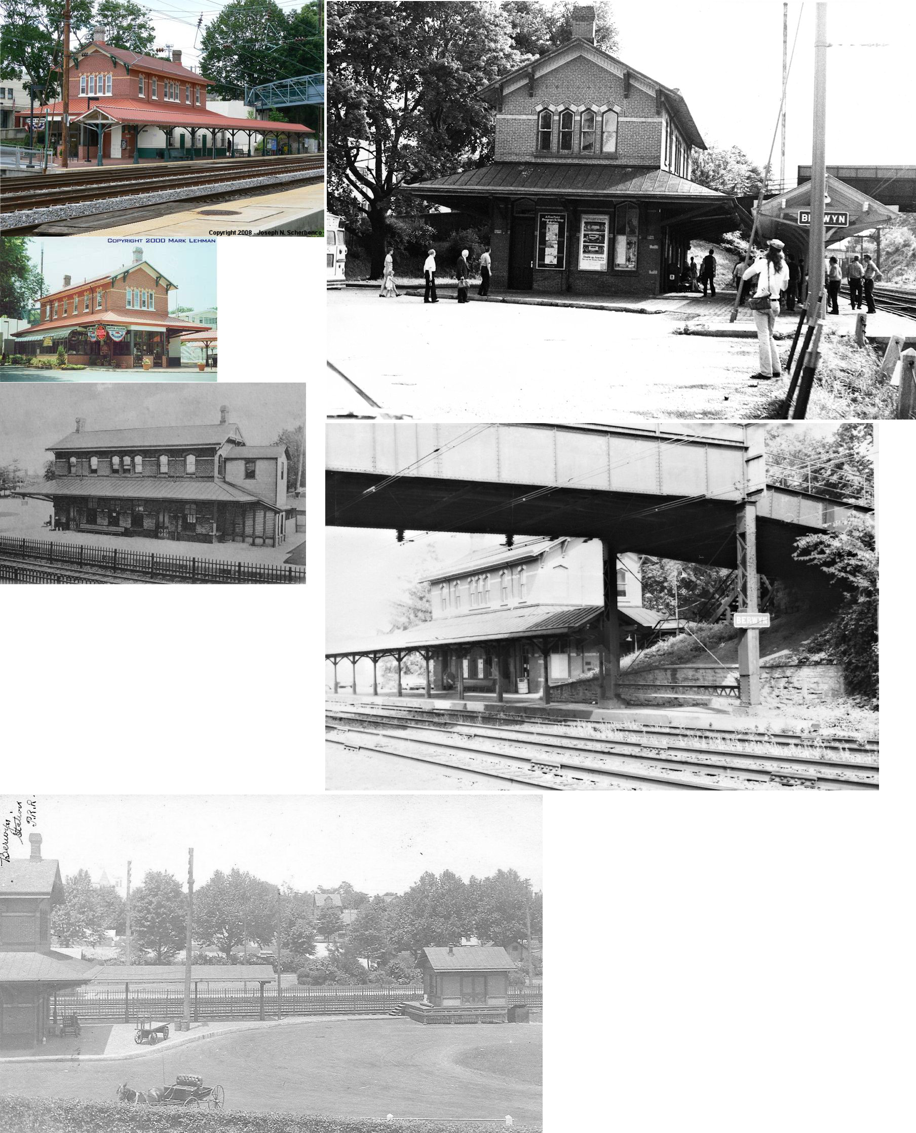
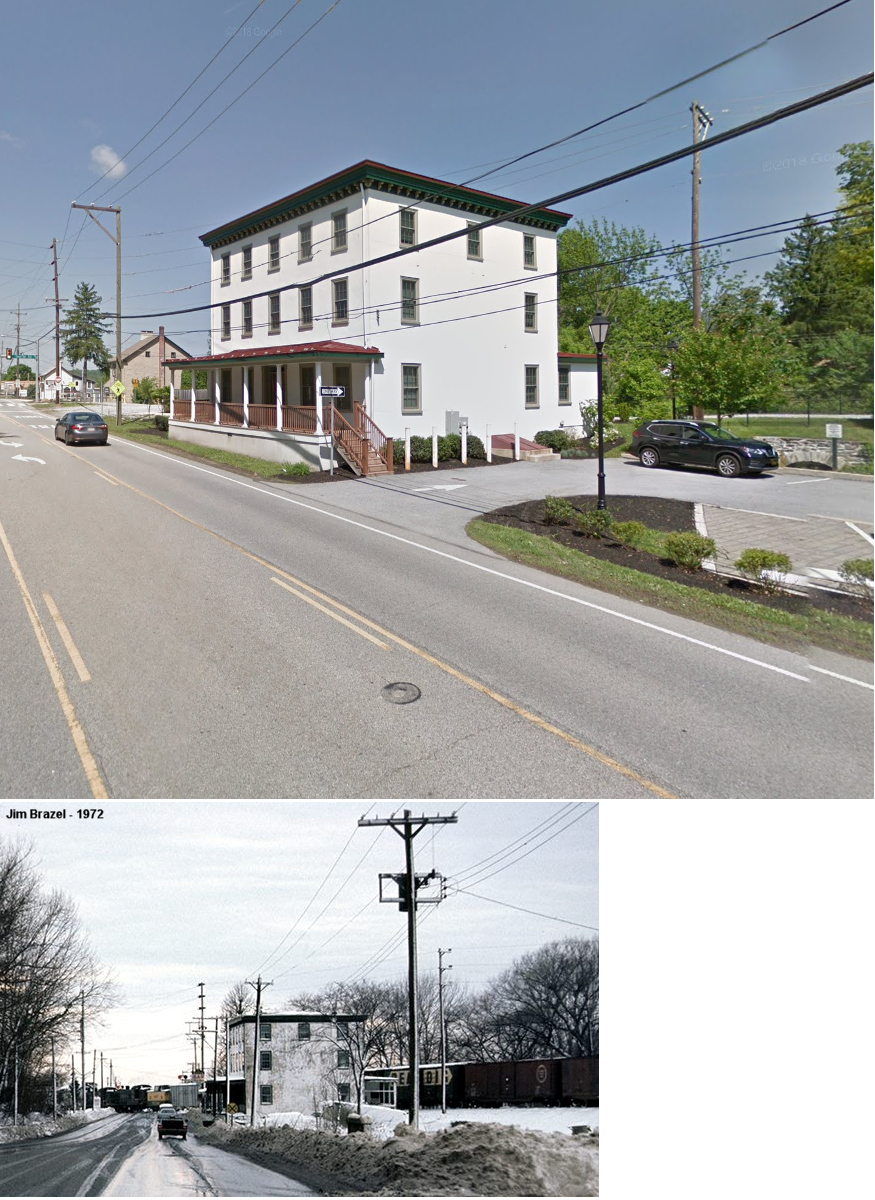
| Berwyn |
|
643 Lancaster Avenue (GPS: 40.047967, -75.442363) |
P | Business/ Railroad |
1900 | In Use | Brick |
|
| Buck Run (GUM TREE) |
|
Off the NW side of Buck Run Road between Beaver Dam Road and Springdell Road (GPS: 39.923586, -75.849853) |
P | Private | ???? | Gone | Wood |
|
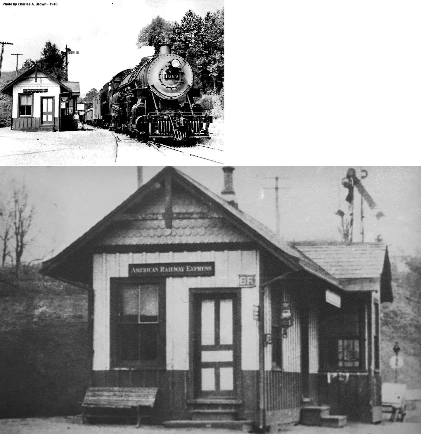
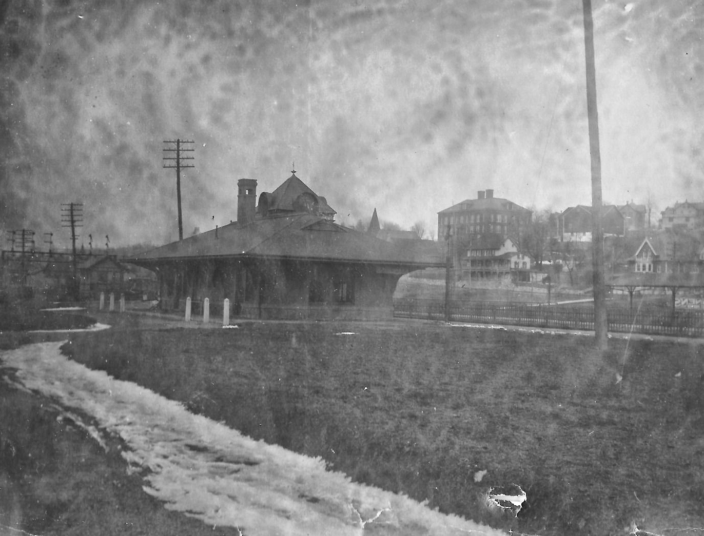
| Chadds Ford Junction |
AND  |
144 Fairville Road (GPS: 39.868366, -75.597511) |
F | Businesses | ???? | In Use | Wood |
|
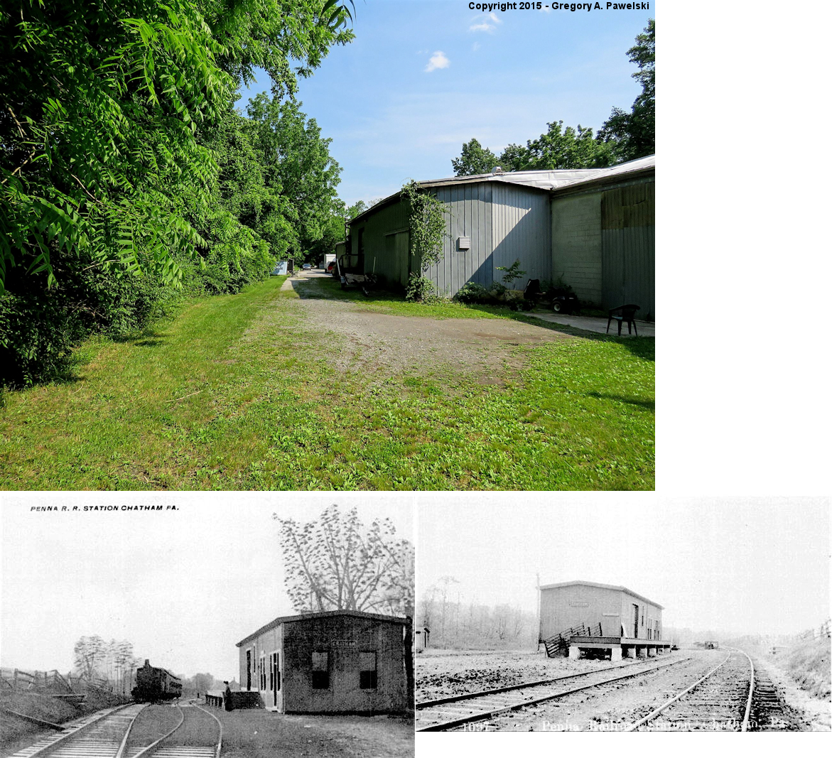
| Chatham |
|
Gap-Newport Pike NW of town center (PA841 & PA41) (GPS: 39.857362, -75.827200) |
C | Storage | ???? | Gone | Wood | |
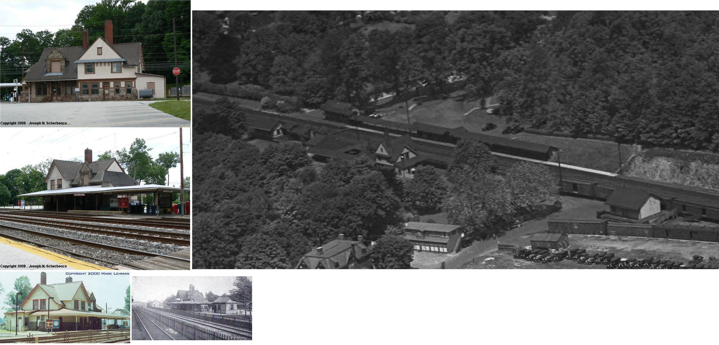
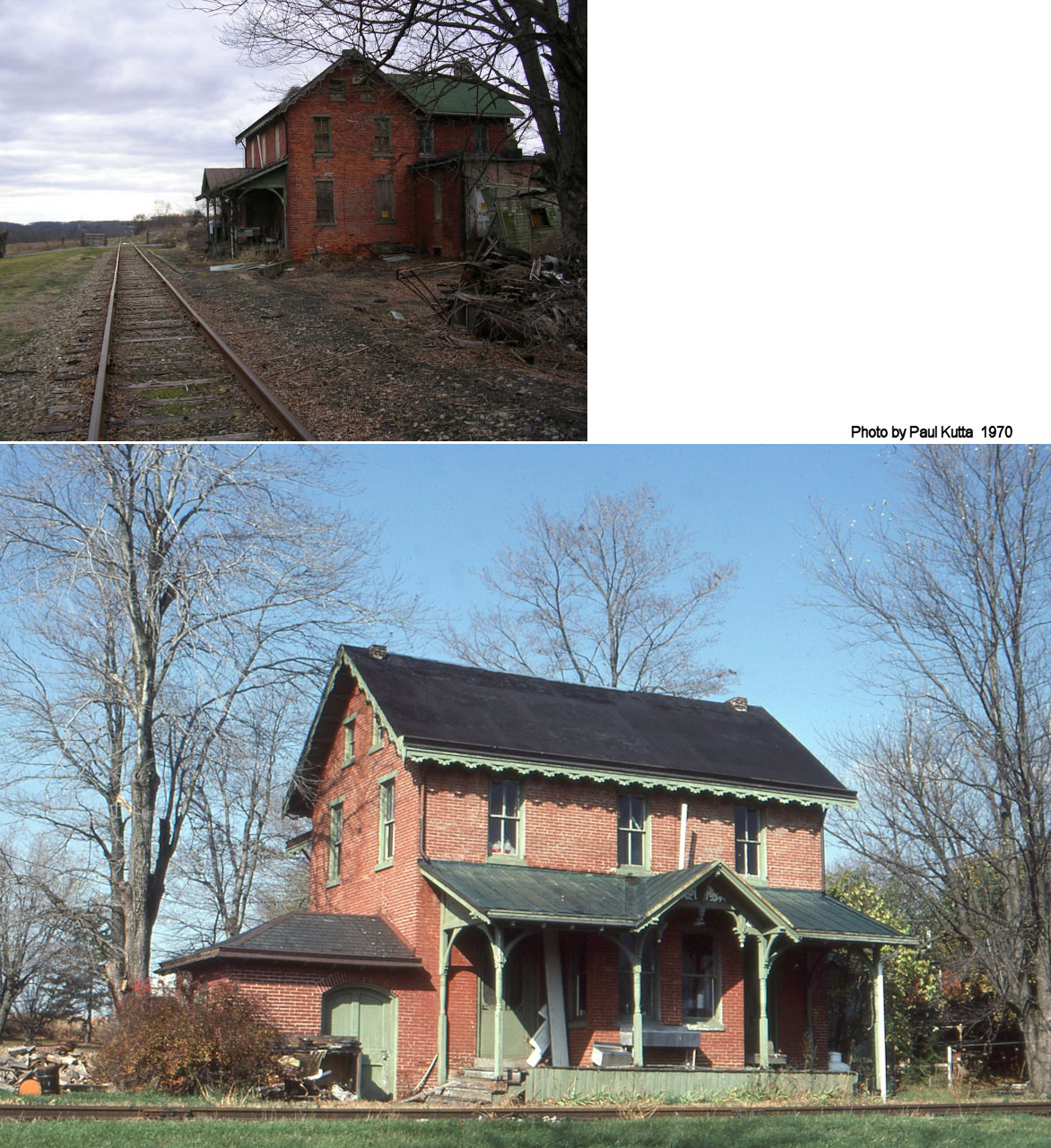
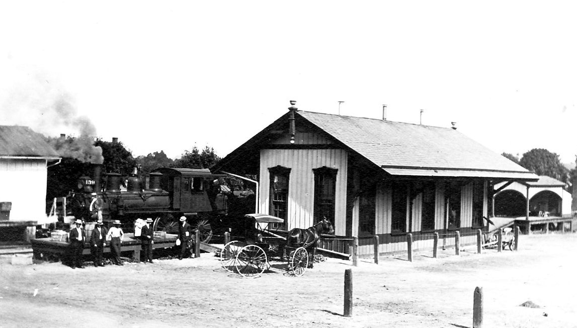
| Coatesville |
|
North side of Fleetwood Street at 3rd Avenue (GPS: 39.985749, -75.820962) |
P | Vacant | 1869 | In Use | Brick |
|
| Cossart |
|
South Creek Road (a.k.a. Chadds Ford Road) (GPS: 39.846110, -75.596407) |
P | Residence | 1929 | ???? | Stone |
|
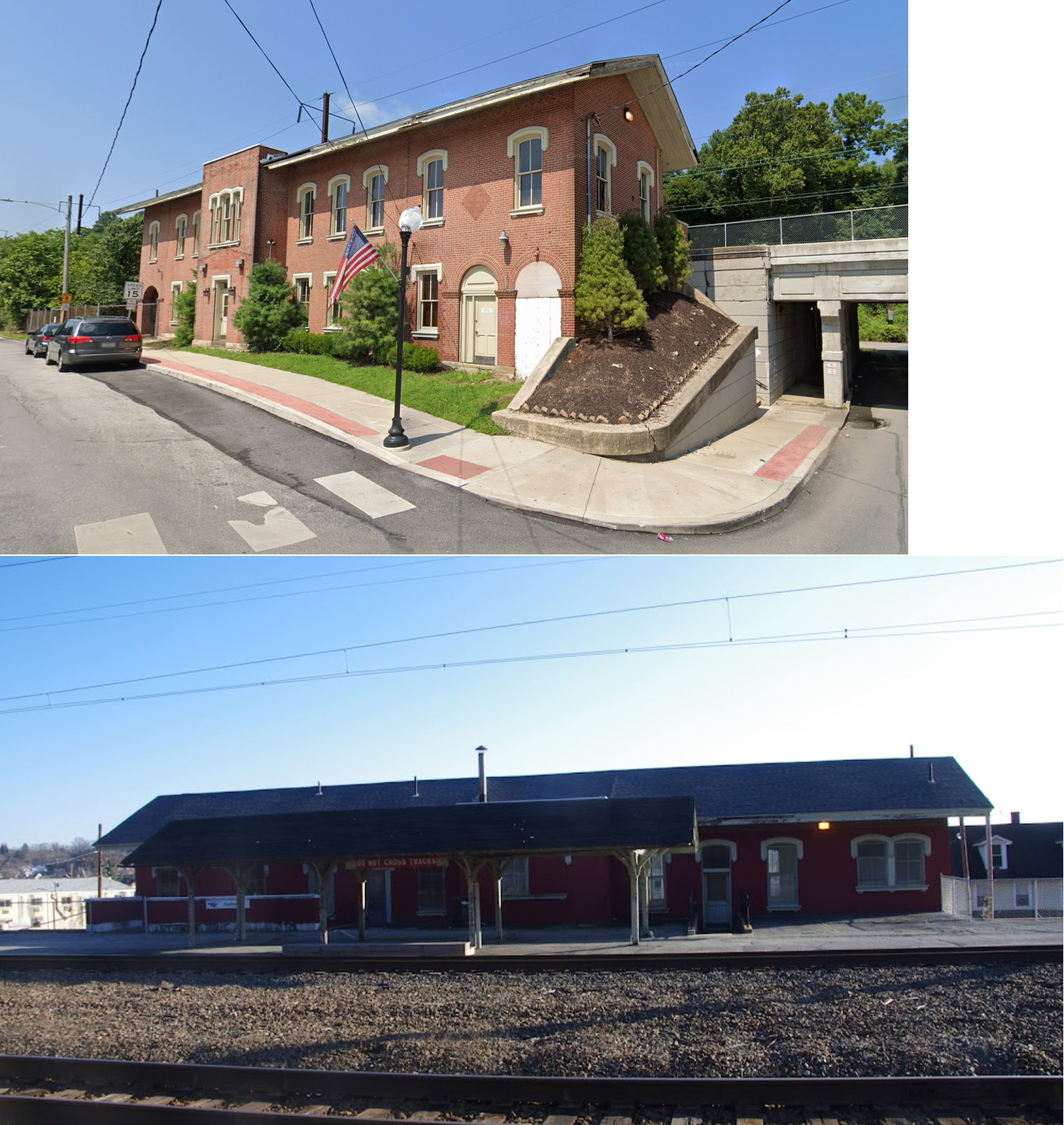
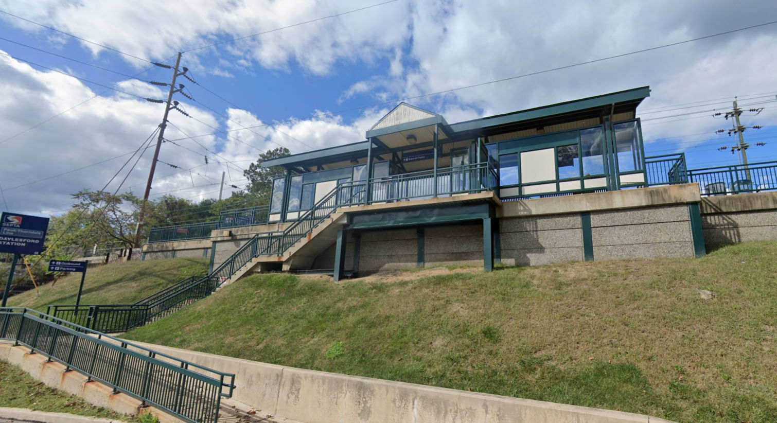
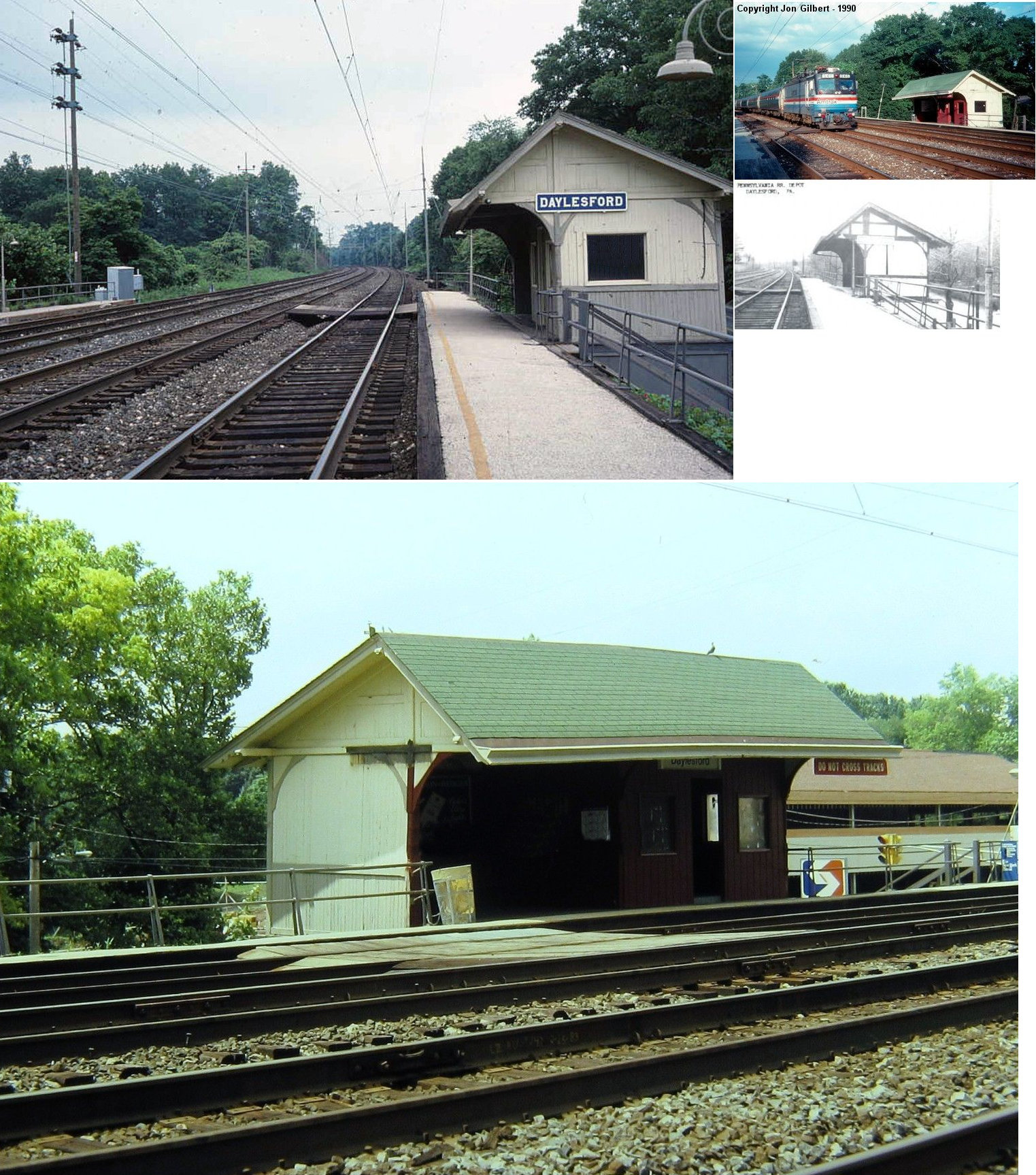
| Daylesford |
 |
Old Lancaster Road near Lancaster Avenue (GPS: 40.042859, -75.460617) |
P | Railroad | ???? | In Use | Metal | |
| Devon |
|
North Devon Boulevard north of U.S. 30 (GPS: 40.047221, -75.422919). |
P | Railroad | 1883 | In Use | Stucco |
|
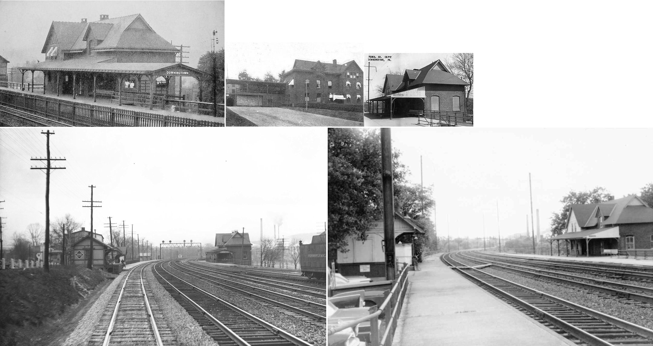
| Downington |
 AND |
159 Viaduct Ave south of Lancaster Avenue (US-30) (GPS: 40.002157, -75.710773) |
P | Railroad | 1990s | In Use | Metal | |
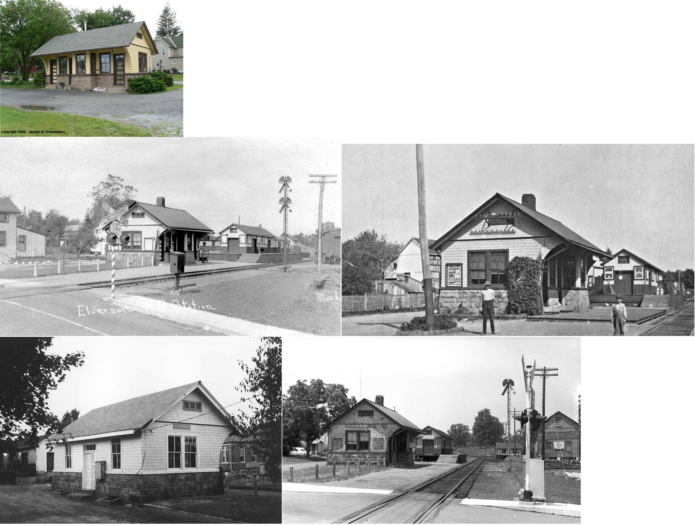
| Elverson |
 |
North side of East Main Street (GPS: 40.157435, -75.828996) |
P | Office | 1921 | Gone | Brick | |
| Elverson |
|
North side of East Main Street (GPS: 40.157655, -75.829090) |
F | Vacant | ???? | Gone | Wood | |
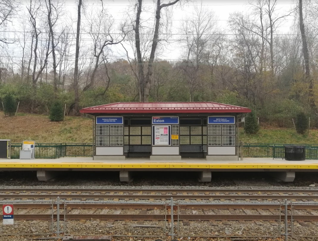
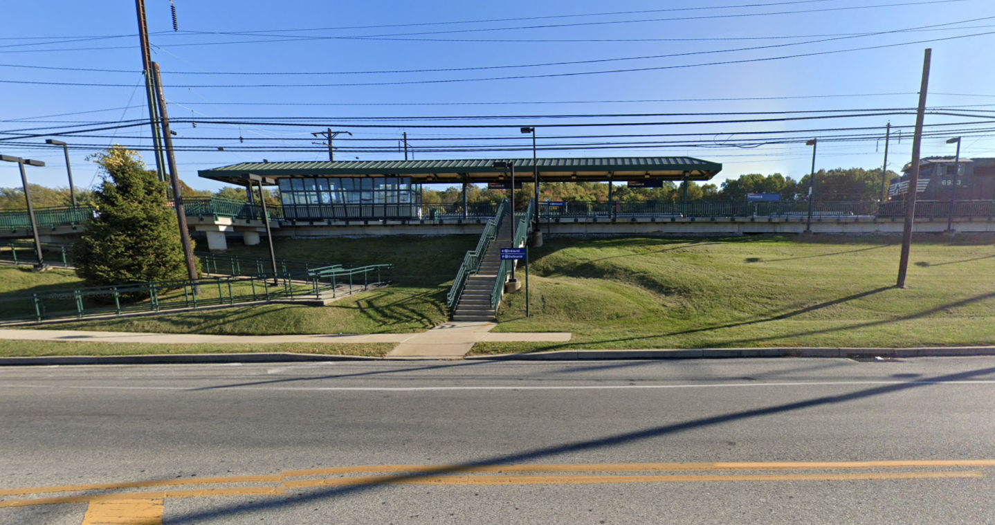
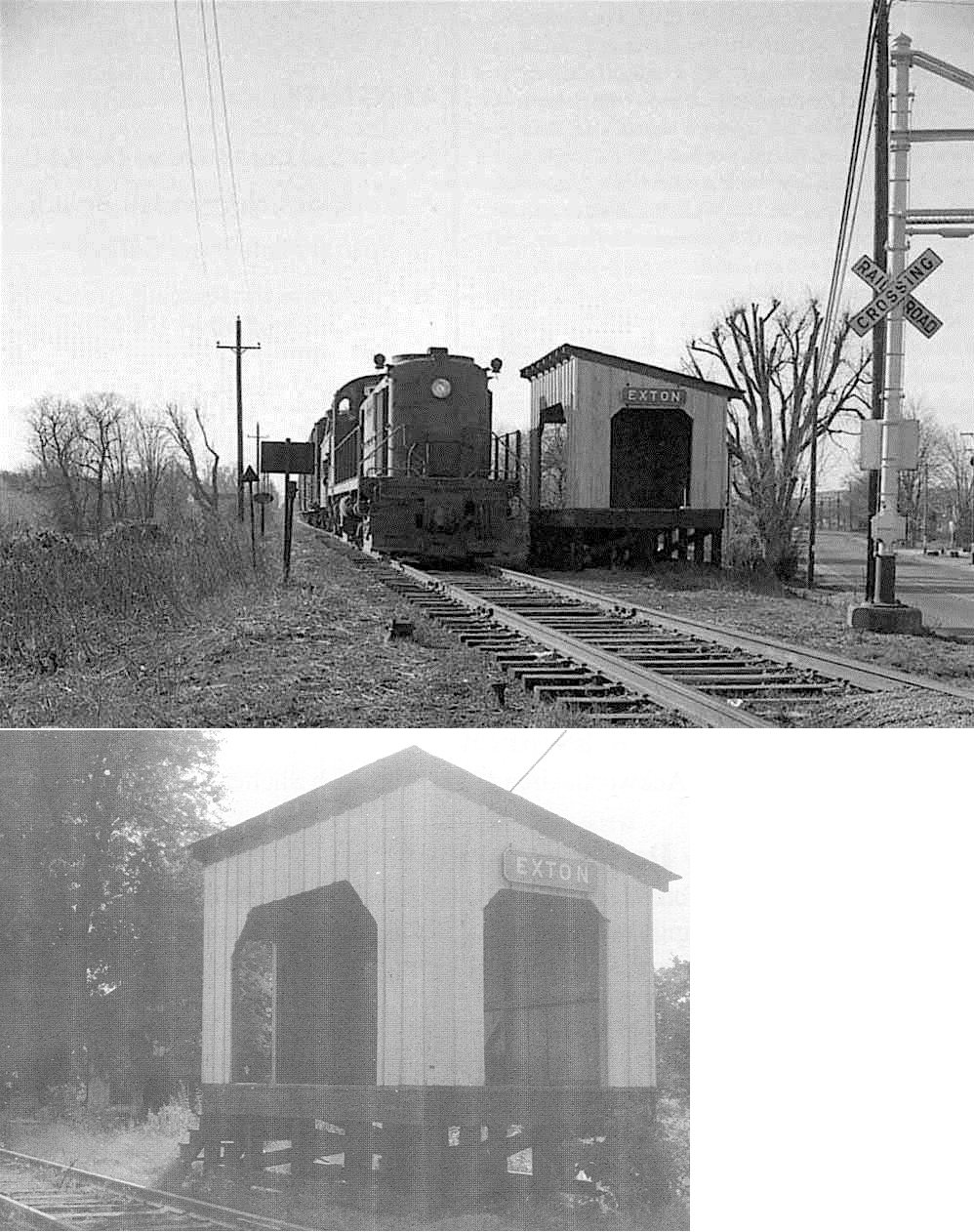
| Exton |
 |
North Side of Lincoln Highway (US-30) (GPS: 40.029332, -75.617756) |
P | Vacant | ???? | Gone | Wood |
|
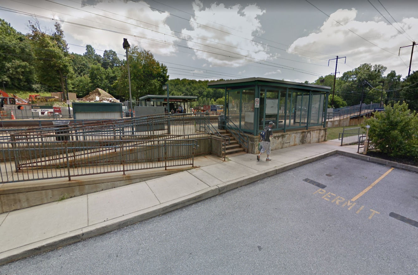
| Exton |
AND |
425 Walkertown Rd, east of Pottstown Pike (PA100) (GPS: 40.019322, -75.621708) |
P | Railroad | 2018 | In Use | Metal | |
| Glen loch |
|
North side of White Woods Lane east of Phoenixville Pike (GPS: 40.029239, -75.584929). |
P | Vacant | 1891 | In Use | ???? |
|
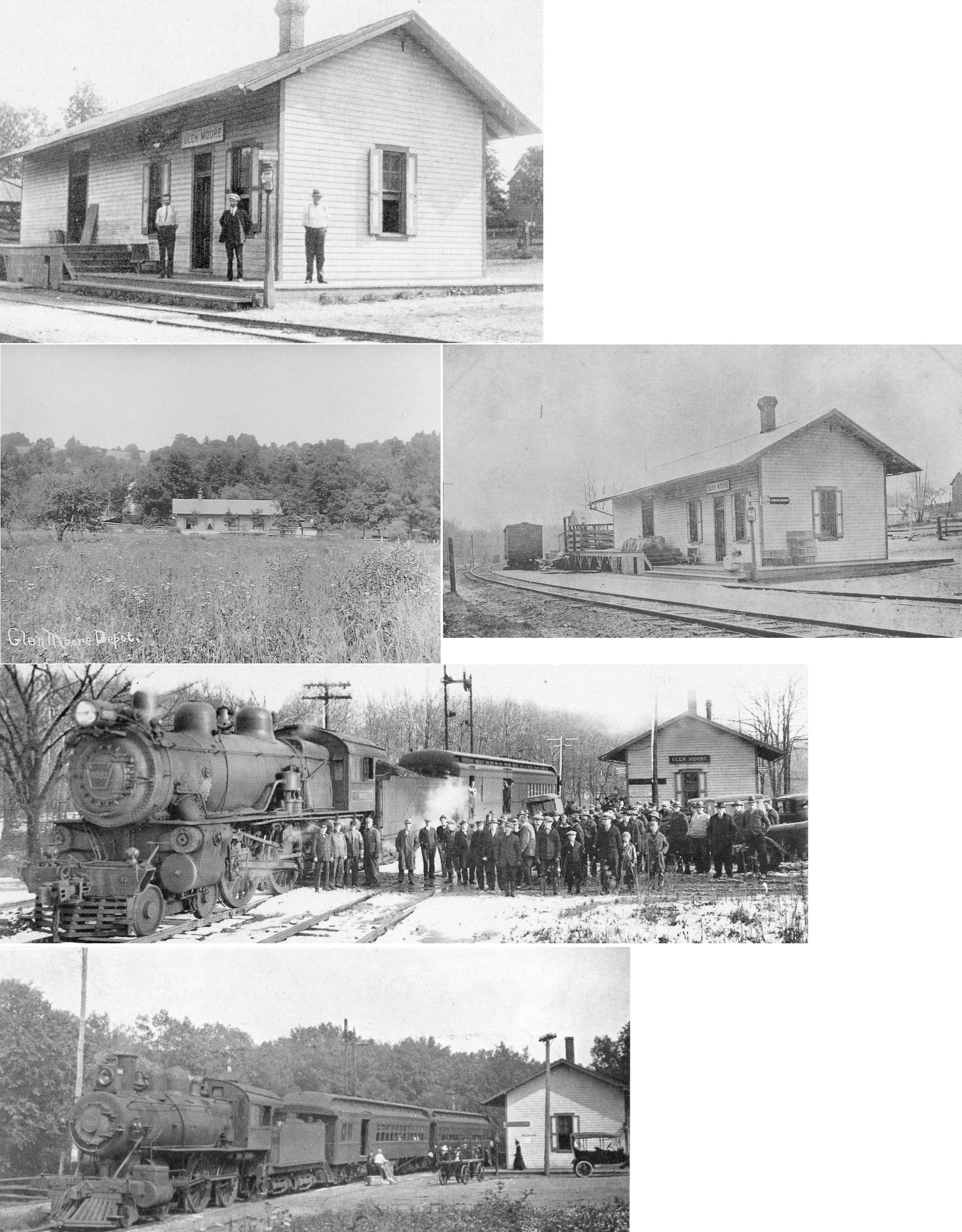
| Glenmoore |
|
East corner of Fairview Road and Creek Road (GPS: 40.092086, -75.774905) |
P | Residence | ???? | Gone | Wood |
|
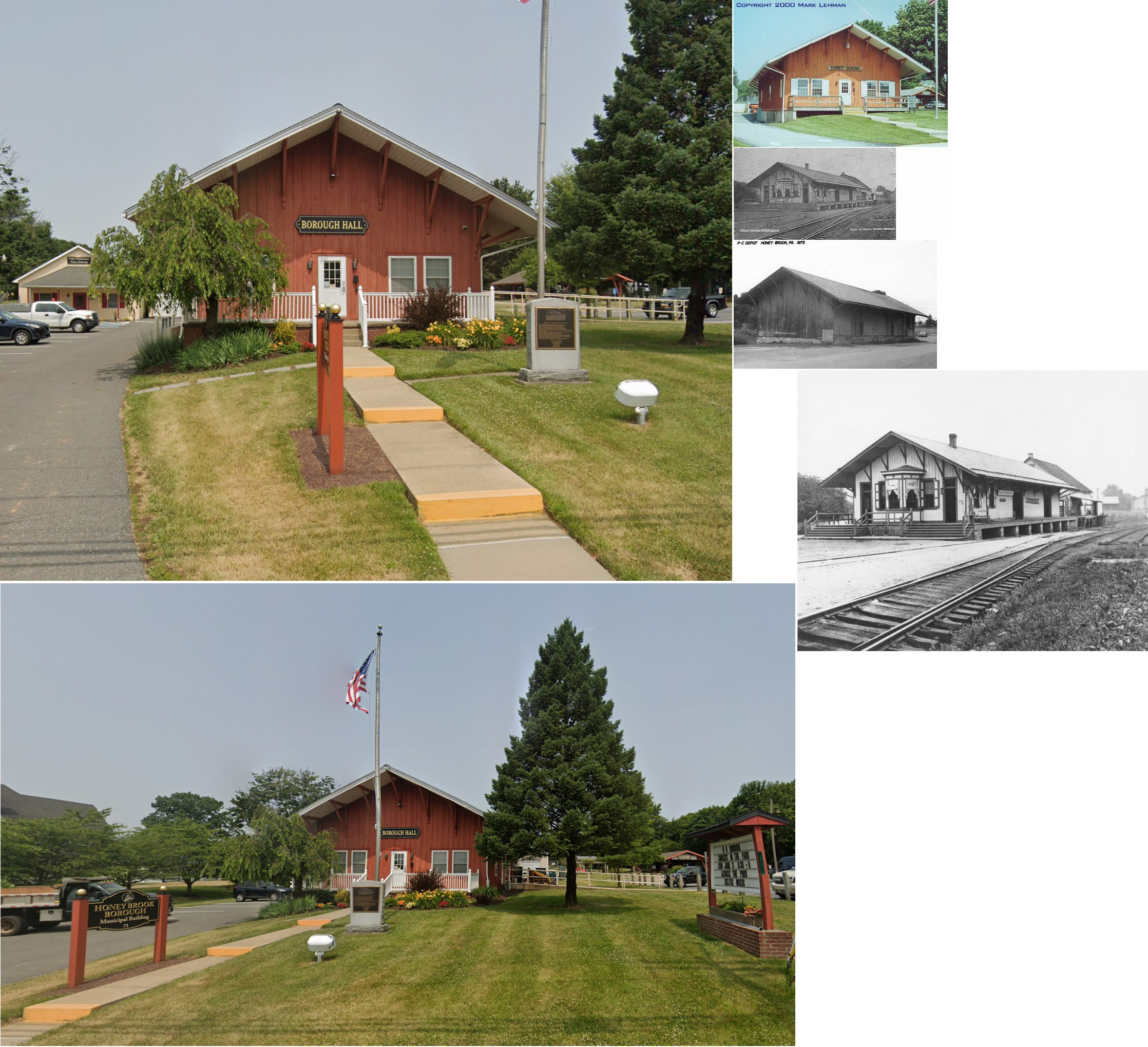
| Honey
Brook (Waynesburg) |
|
71 Pequea Avenue (GPS: 40.095406, -75.914543) |
P | Municipal | ???? | Gone | Wood | |
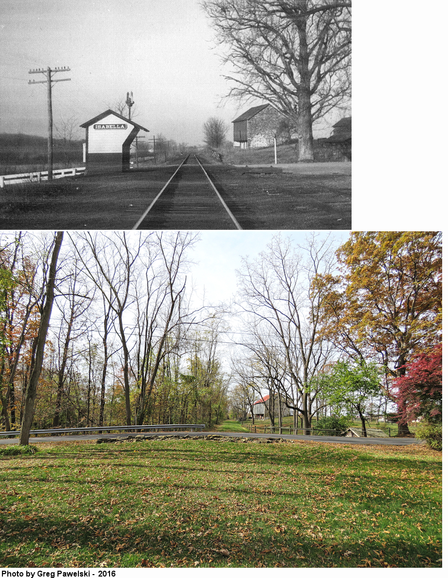
| Isabella |
|
Isabella Road (GPS: 40.121002, -75.837983) |
C | Residence | ???? | Gone | Brick |
|
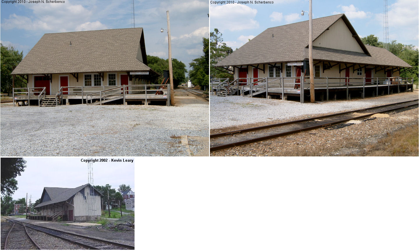
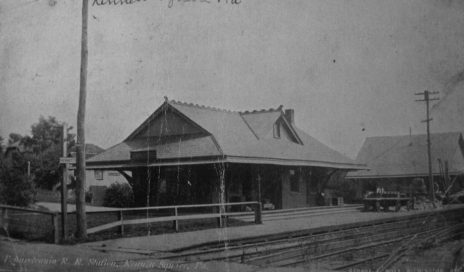
| Kennett Square |
|
East side of South Broad Street (GPS: 39.842676, -75.708392) |
F | Railroad | ???? | In Use | Brick |
|
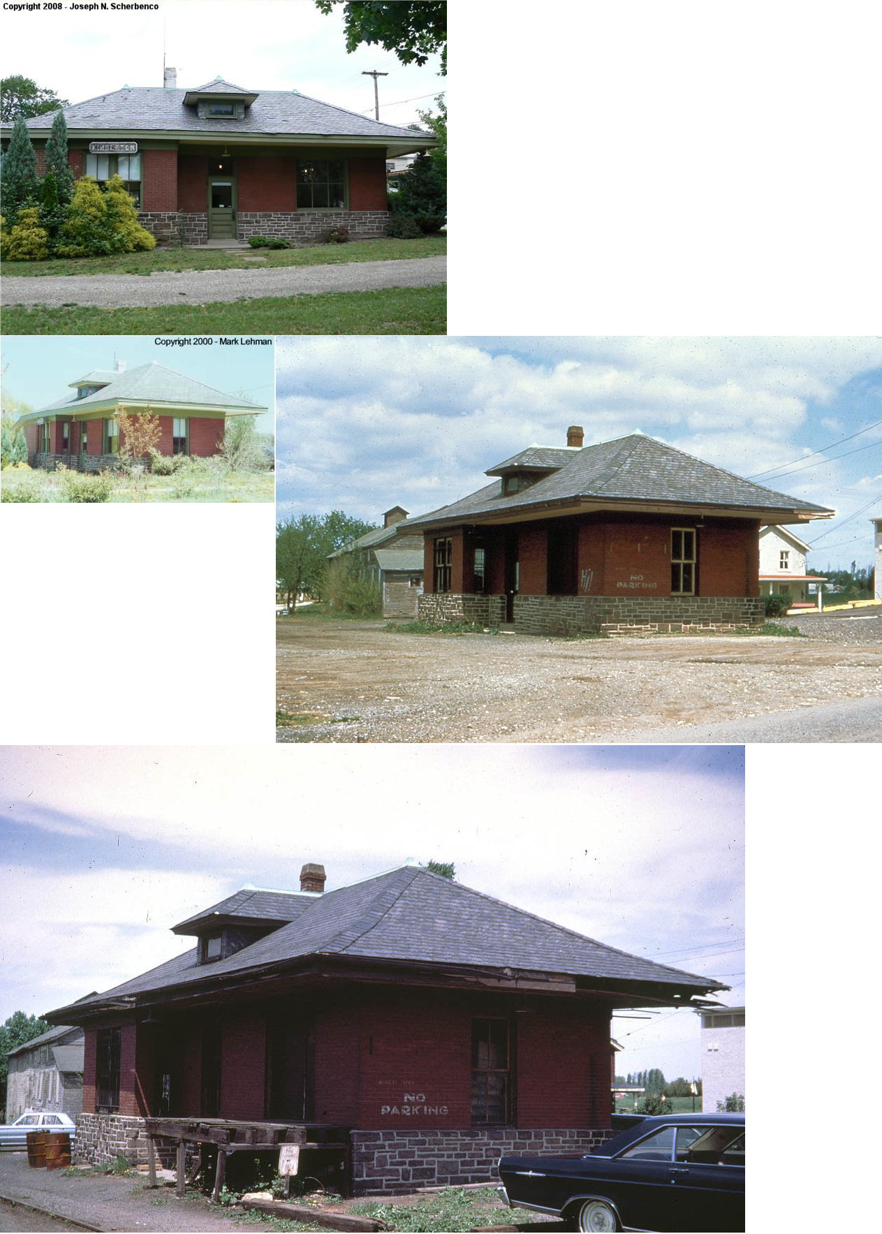
| Kimberton |
|
2205 Kimberton Road (GPS: 40.131001, -75.571943) |
P | Office | 1918 | Gone | Brick | |
| Kirkland Station |
 |
1370 Kirkland Avenue (just off Boot Road) in West Whiteland Township. (GPS: 40.010536, -75.601556) |
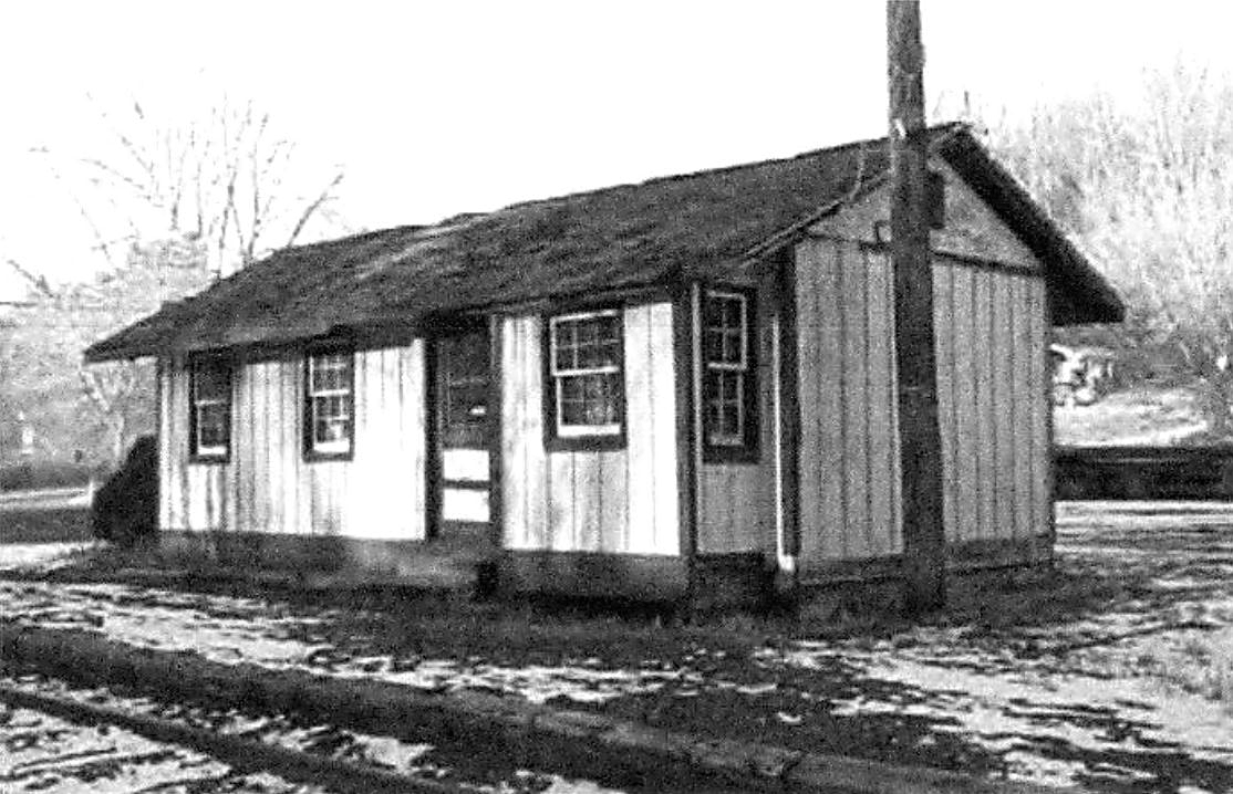
C | Residence | 1870 | None | Brick |
|
| Lincoln University |
|
Ashmun Avenue (GPS: 39.799920, -75.922308) |
P | Vacant | 1867 | In Use | Brick |
|
|
Morstein (Woodland) (Zermatt) |
|
Weston Way SE of King Road (GPS: 40.020359, -75.581811) |
P | Business | 1862 | Gone | Brick |
|
| Malvern |
|
West side of North Warren Avenue on the south side of the tracks. (GPS: 40.036357, -75.515525) |
P | Railroad/ Business |
1900 | In Use | Brick | |
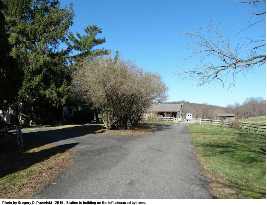
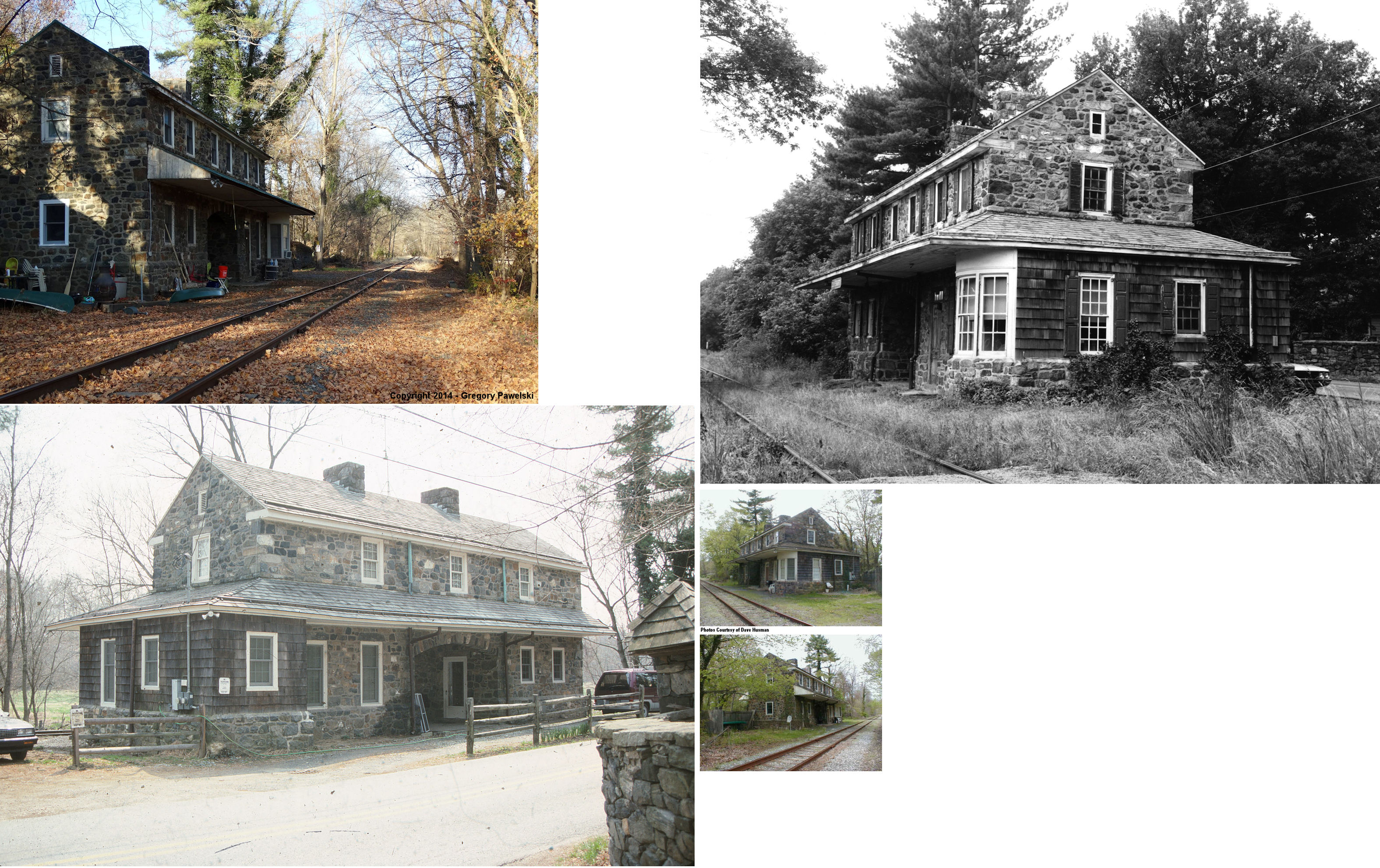
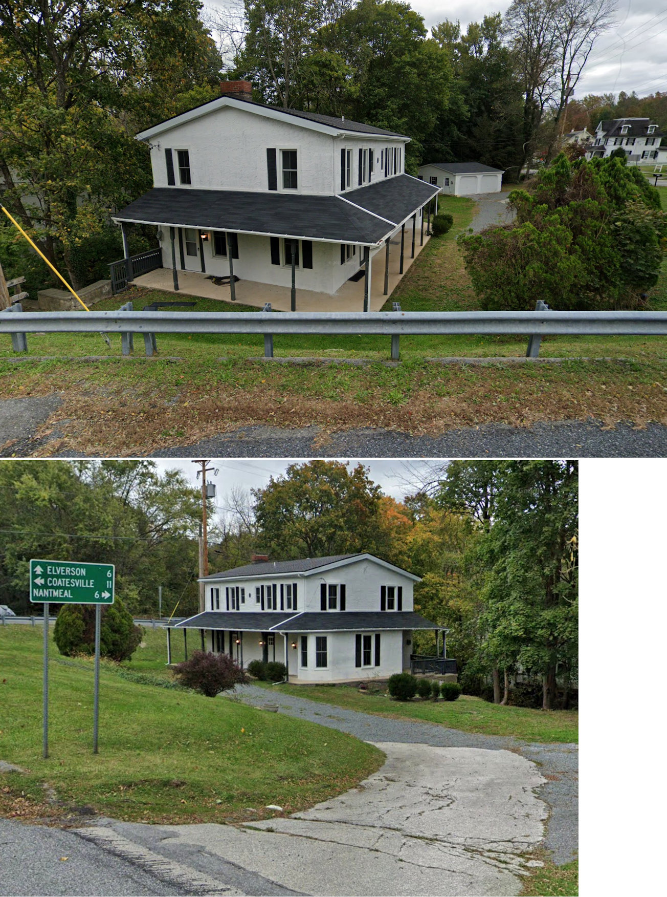
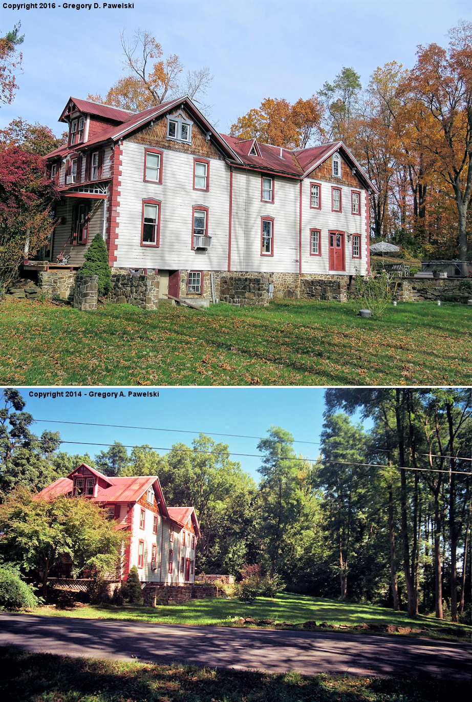
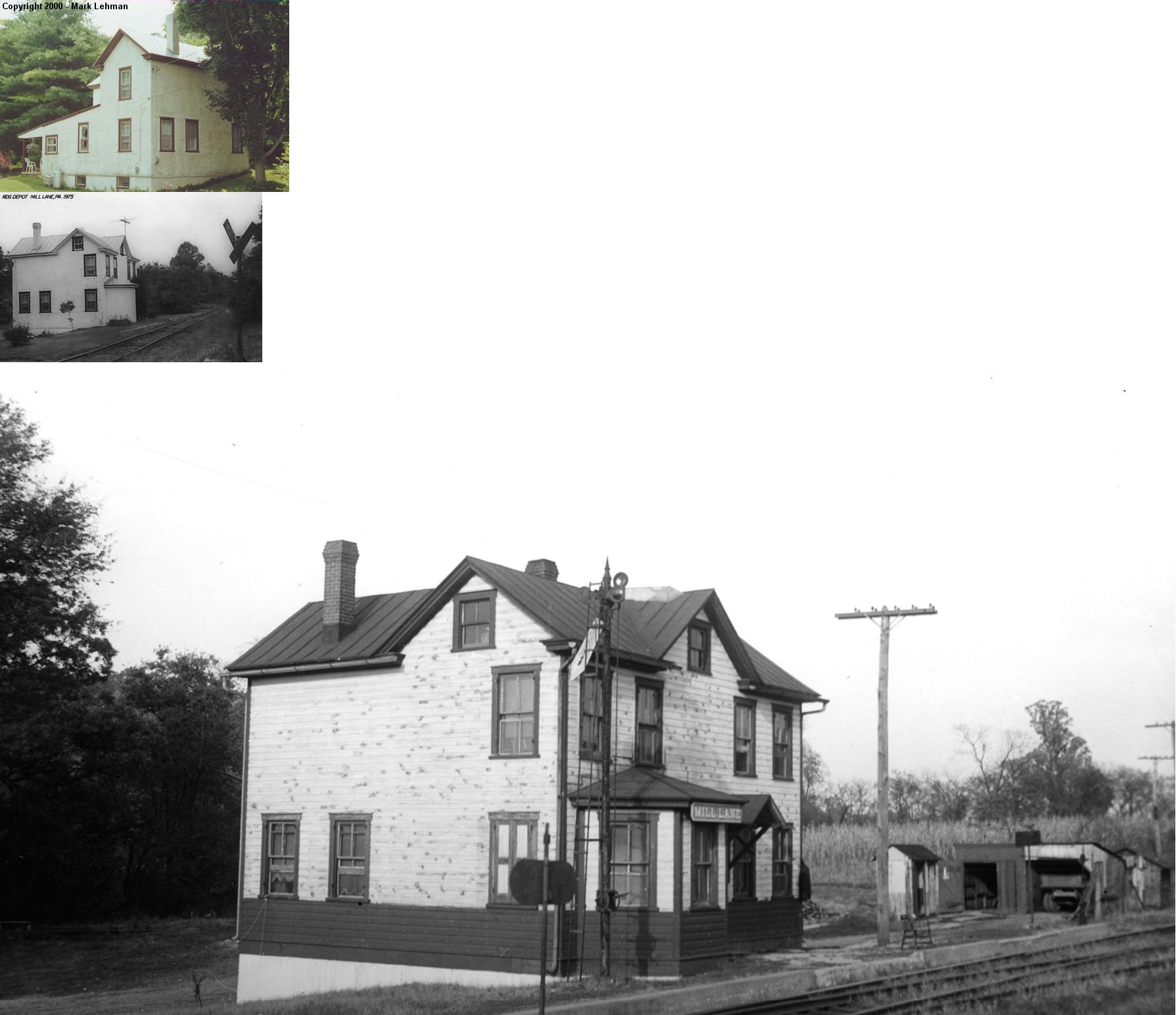
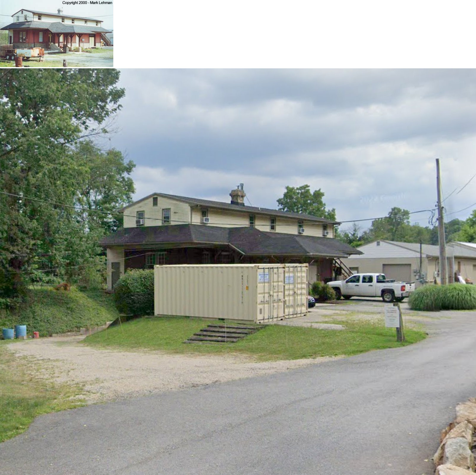
| Mill Lane |
|
7 Mill Lane (GPS: 40.049250, -75.554945) |
P | Private | 1836 | Gone | Stucco |
|
| Modena |
|
West side of Union Street on the south side of the tracks. (GPS: 39.962846, -75.801260) |
P | ???? | ???? | In Use | Wood |
|
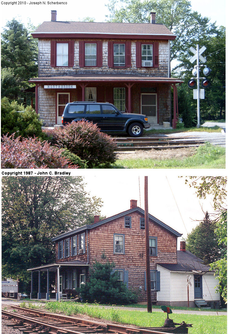
| Northbrook (Marshalls Sta.) |
|
Northbrook Road at Beagle Road (GPS: 39.920304, -75.689160) |
C | Residence | 1860 | In Use | Wood |
|
| Northbrook |
|
North side of the tracks west of Northbrook Road (GPS: 39.919986, -75.689944) |
F | Business | ???? | In Use | Wood |
|
| Oxford |
AND  |
Market Street at North 4th Street & Railroad Avenue (GPS: 39.785120, -75.977076) |
P | Police Station | 1902 | In Use | Brick | |
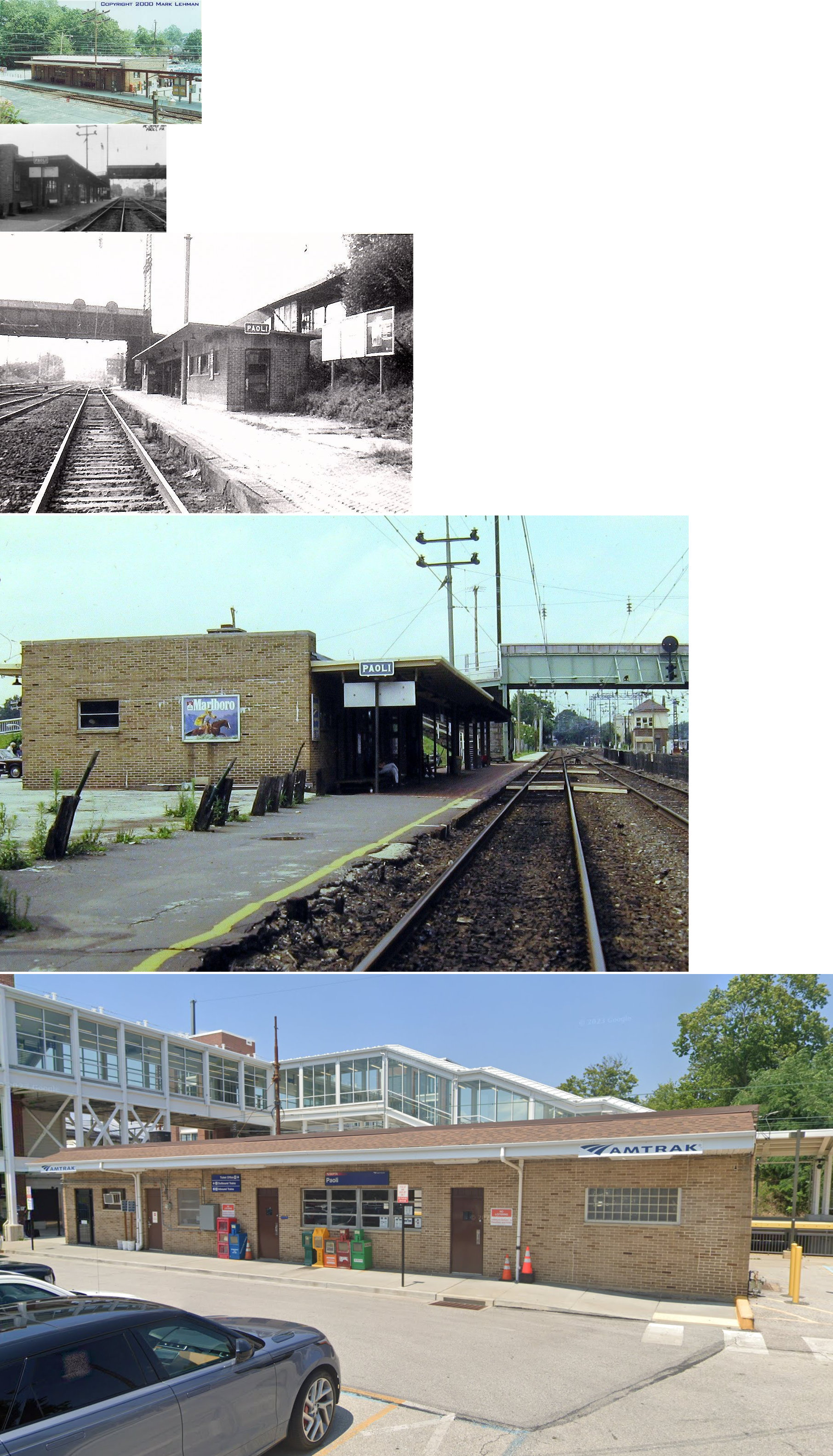
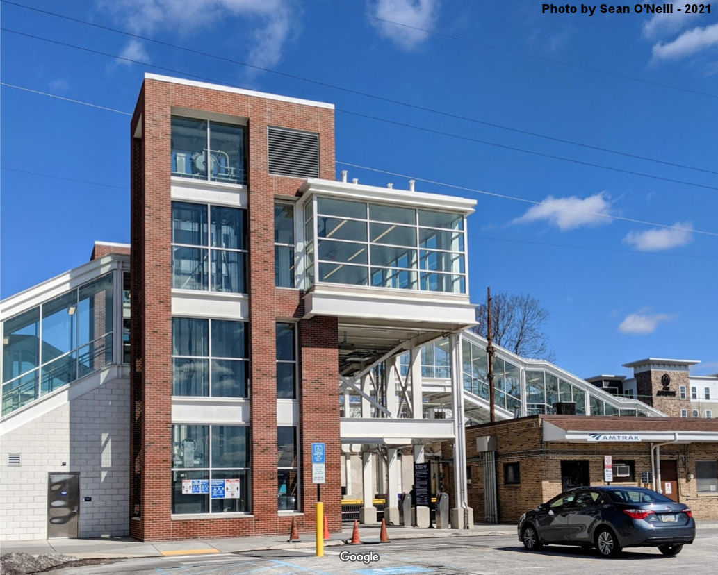
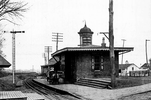
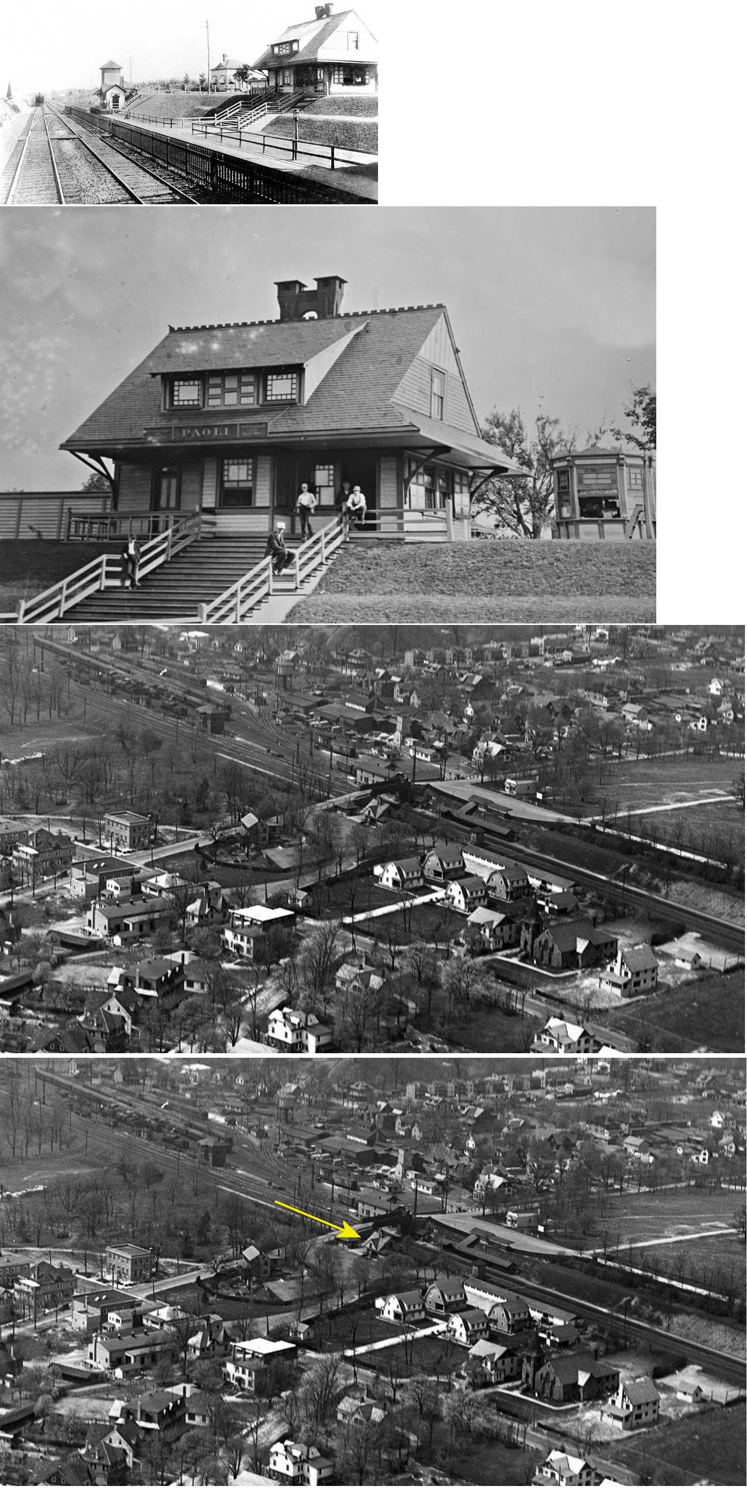
| Paoli |
|
East side of North Valley Road near U.S. 30 (GPS: 40.042840, -75.483649) |
P | Railroad | 1953 | In Use | Brick | |
| Paoli |
|
East
side of Valley Road between Central Avenue and Lancaster Avenue (GPS: 40.042961, -75.483607) |
P | Railroad | 2019 | In Use | Brick |
|
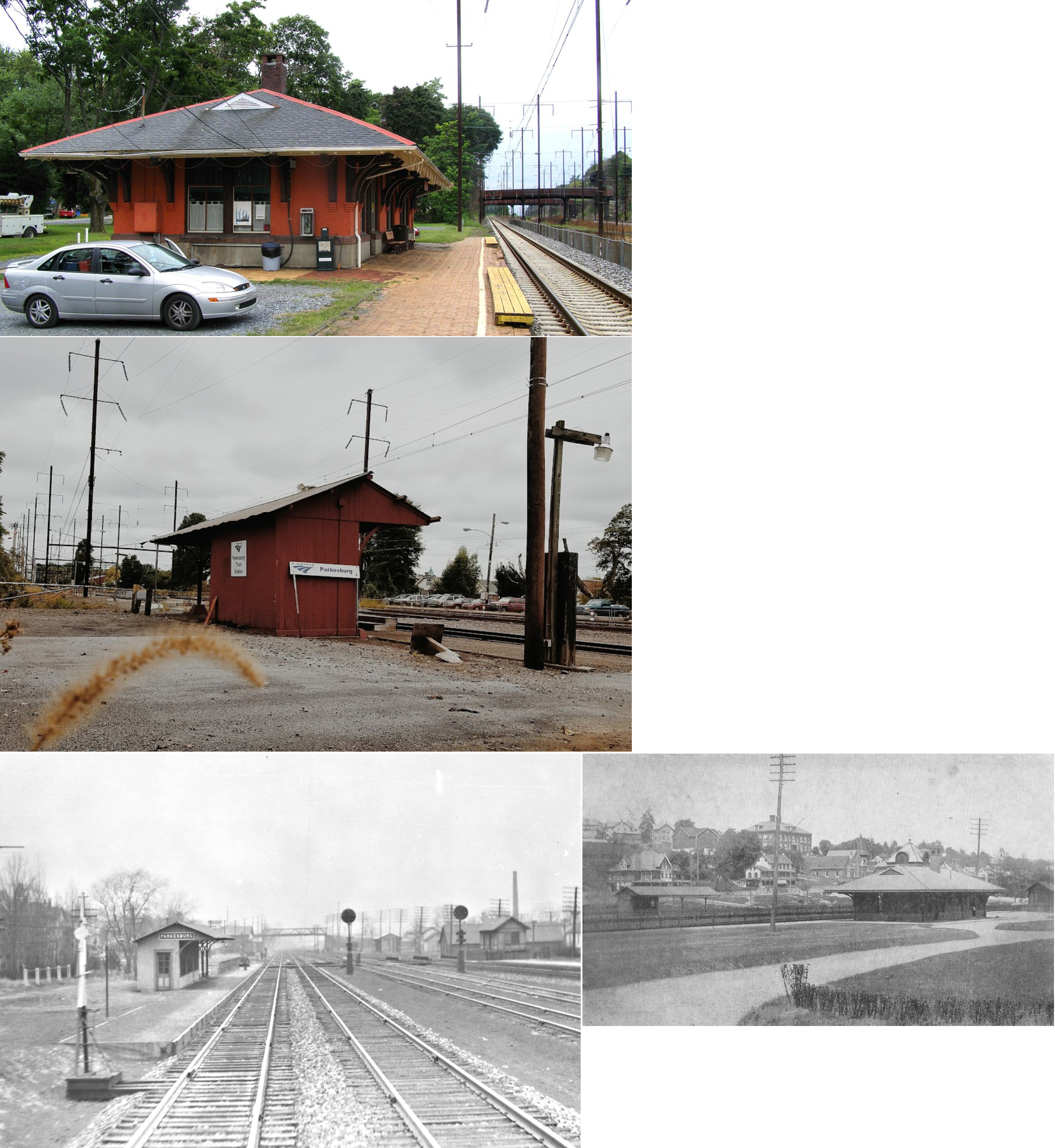
| Parkesburg |
|
501 Maple Street between Culvert and Chestnut Streets. (GPS: 39.959101, -75.922339) |
P | Vacant | 1906 | In Use | Brick |
|
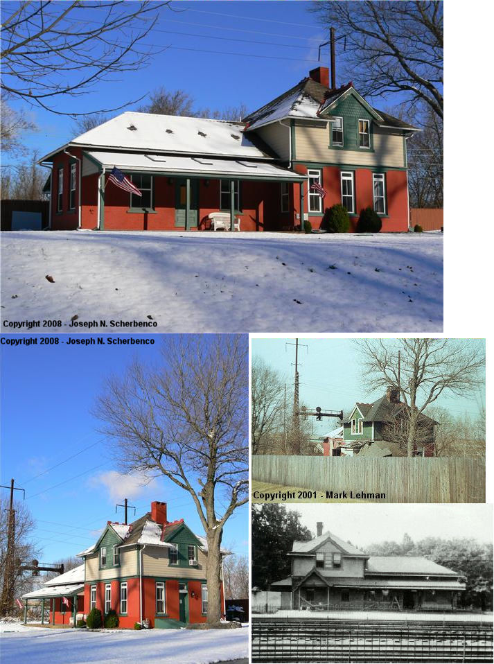
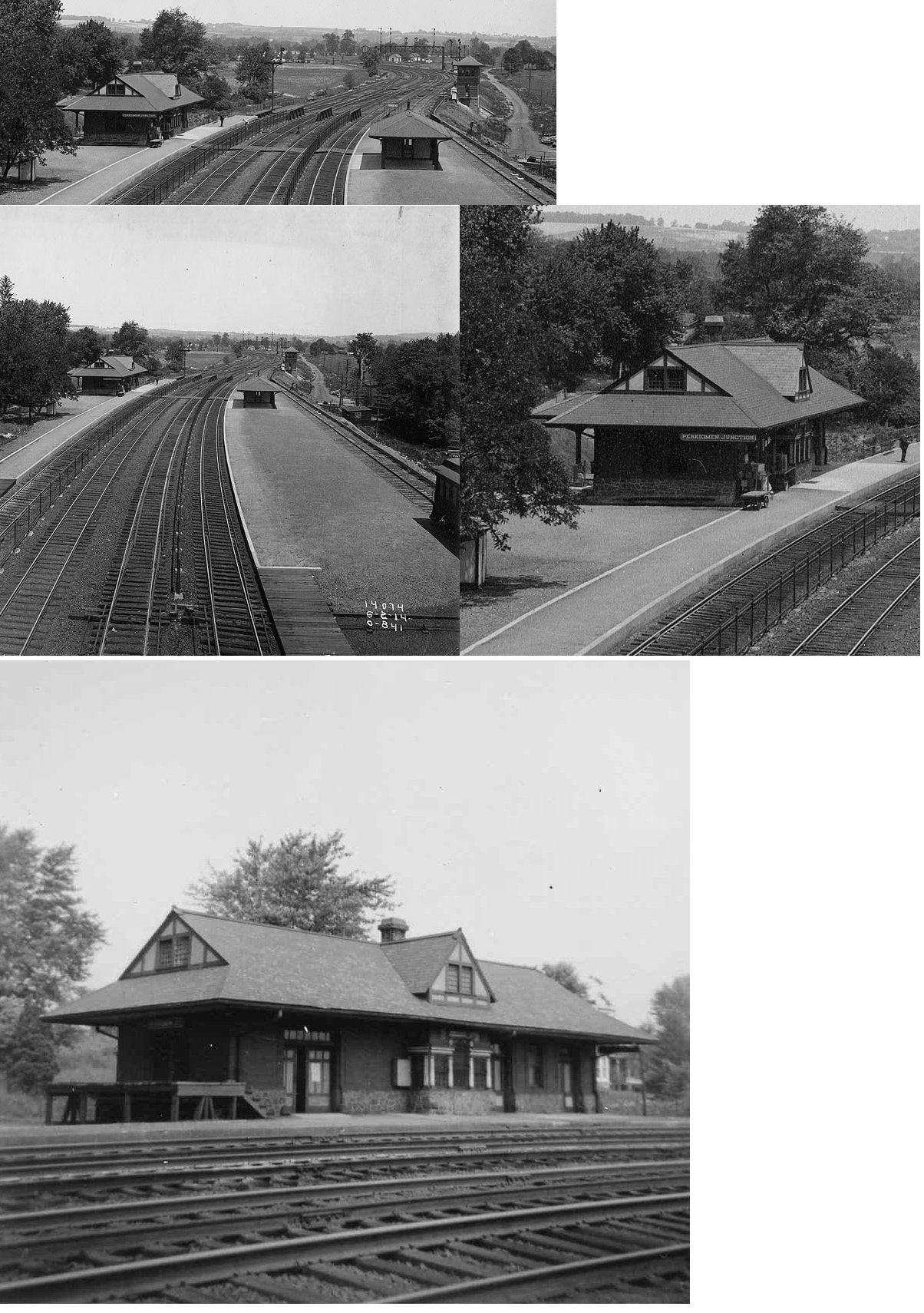
| Perkiomen Junction |
|
South side of Pawling Road on the west side of the tracks. (GPS: 40.115027, -75.472648) |
P | Business | 1934 | In Use | Brick | |
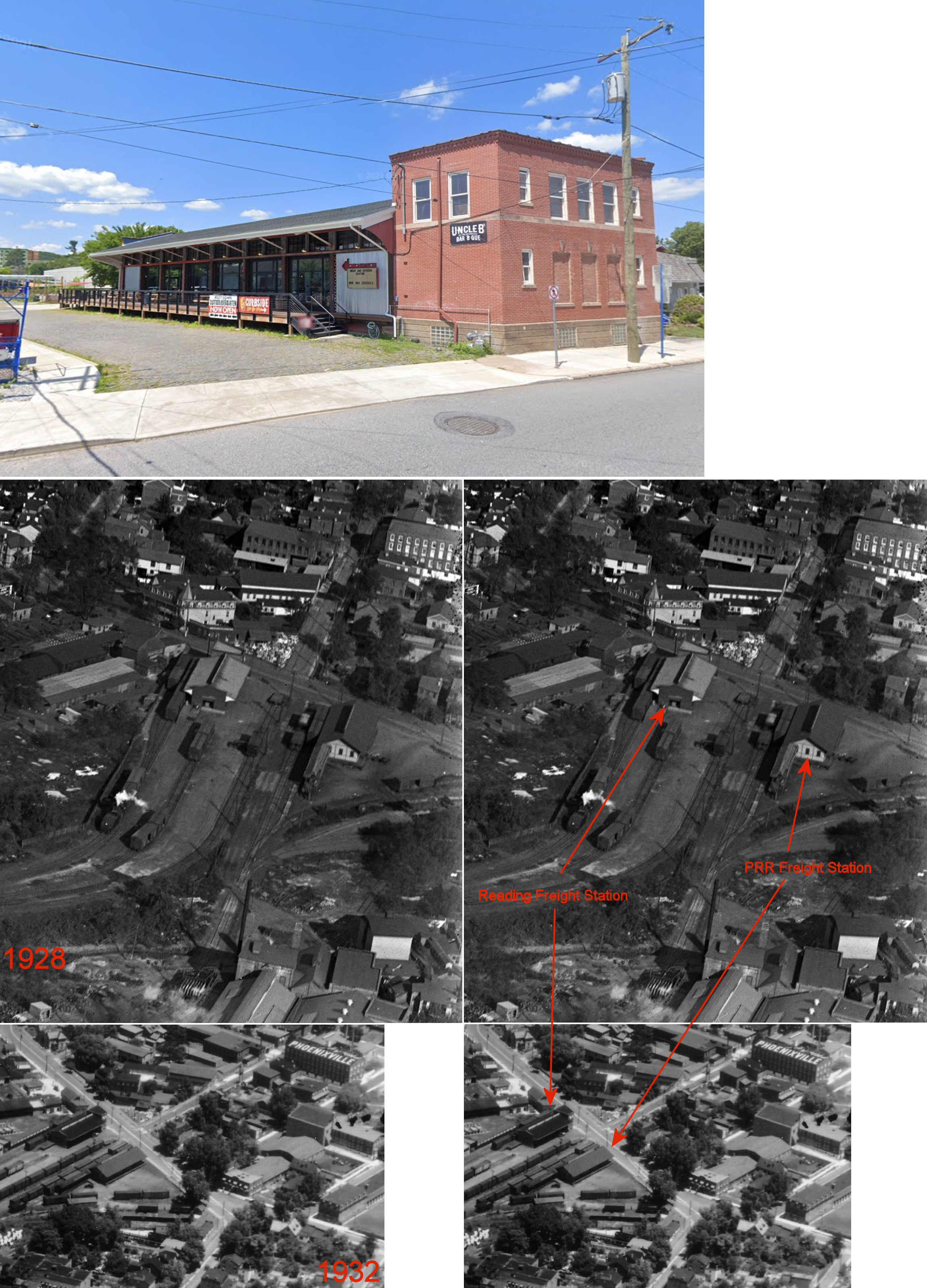
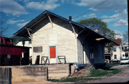
| Phoenixville |
|
Route 29 and
Schuylkill River (GPS: 40.134515, -75.509956) |
C | Business | 1865 | In Use | Stone |
|
| Phoenixville |
 |
425 Bridge Street (GPS: 40.131635, -75.522288) |
F | Business | ???? | Aband. | Brick | |
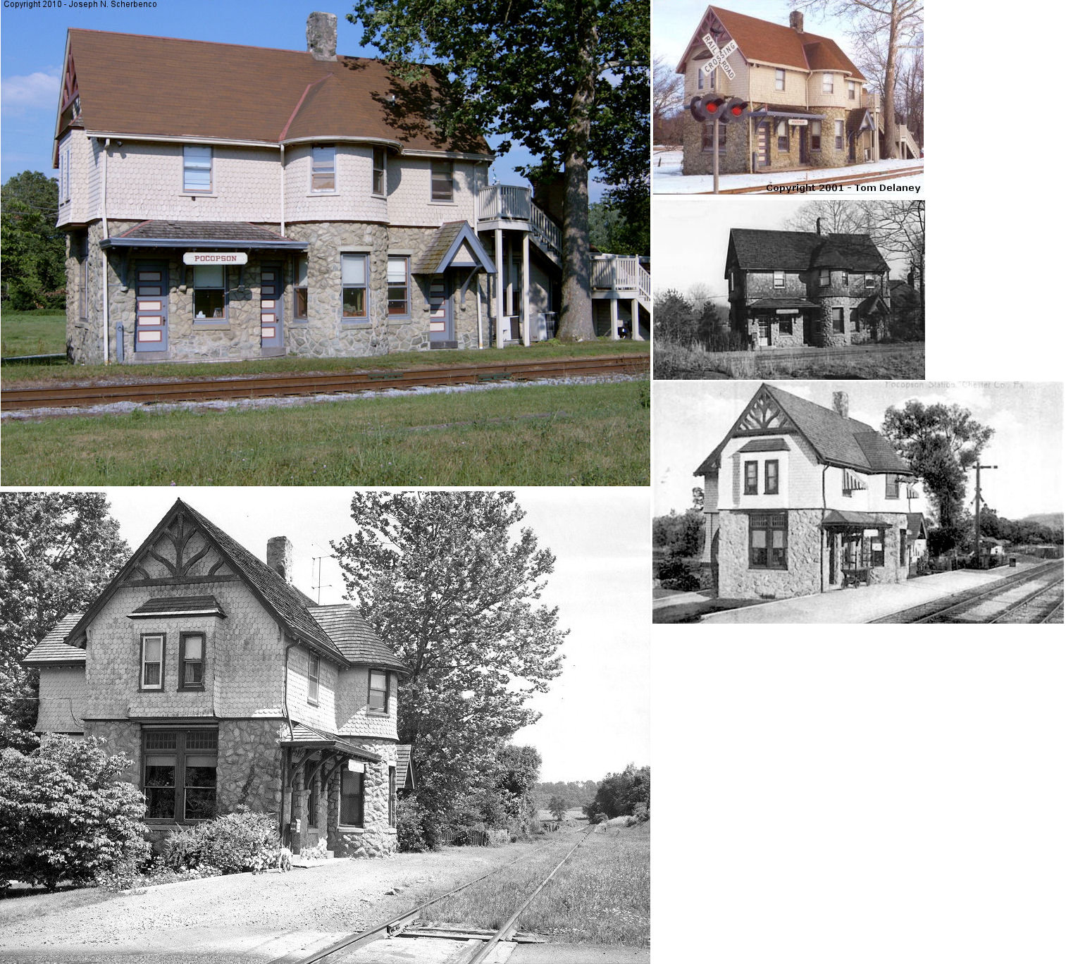
| Pocopson |
|
PA926 and Pocopson Road west of Brandywine Creek (GPS: 39.9002, -75.6252) |
P | Business | 1892 | In Use | Stone |
|
| Rosedale |
|
East side of Norway Road on the north side of the RR grade? |
F | Private | ???? | In Use | Brick |
|
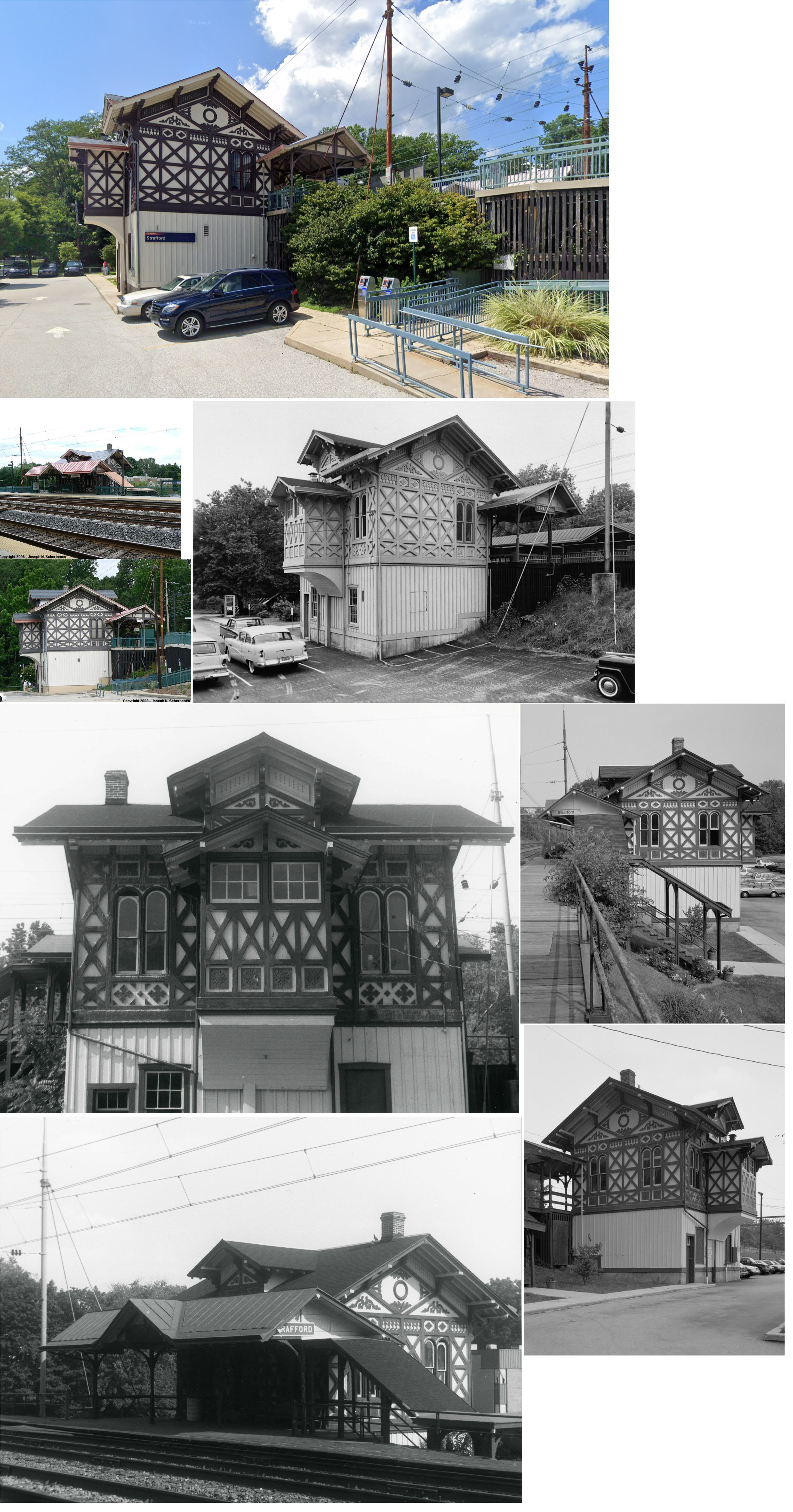
| Strafford |
|
Old Eagle School Road & Strafford Avenue (GPS: 40.049570, -75.403778) |
P | Railroad | 1876 | In Use | Wood |
|
| Thorndale |
|
Bailey Road near Lincoln Avenue (US-30) (GPS: 39.992609, -75.762677) |
P | Railroad | 1999 | In Use | Metal | |
| Valley Forge | |
Valley Forge Road (PA23) at Washington's Headquarters, Valley Forge National Park (GPS: 40.102301, -75.460501) |
P | Museum | 1912 | In Use | Stone |
|
| Westtown (Street Road Sta.) |
|
Southeast side of East Street Road (PA926) SW of Westtown-Thornton Road. (GPS: 39.931897,-75.549231) |
C | Business | 1859 | In Use | Wood |
|
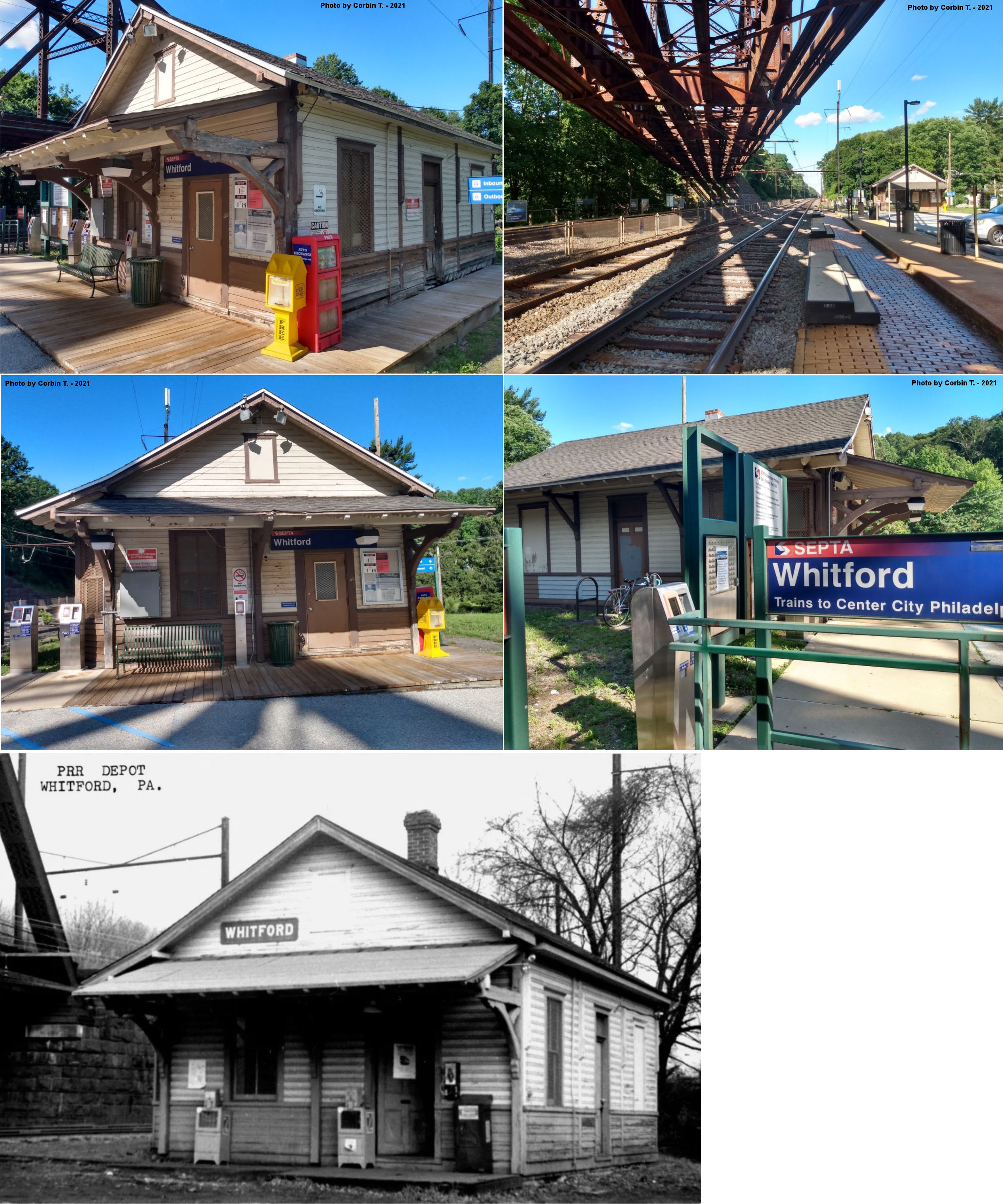
| Whitford (Oakland) |
|
South Whitford Road at Spackman's Lane (GPS: 40.014663, -75.638105). |
C | Vacant | 1880 | In Use | Wood |
|
| Whitford (Oakland) |
|
407 Spackman's Lane west of Whitford Road (GPS: 40.014287, -75.638814). |
F | Business | ???? | In Use | Stone | |
| STATIONS OF THE PAST | ||||||||
| Station Name |
Original Railroad |
Notes | ||||||
| 3 Ton Road |
 |
In 1880, the new line opened on the West Chester Railroad between Frazer and Woodland (Morstein) and the old alignment between Malvern and Woodland was abandoned. The stations at Summit, Ton Road and Hoods Road were abandoned. | ||||||
| Ackworth (Baldwin's STA.) |
|
This station is called "Baldwin's Station" on the 1873 and 1883 maps. It is called Ackworth on the 1923 map. | ||||||
| Aldham |
|
|||||||
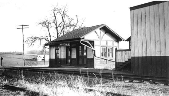
| Anselma (Cambria) |
|
Town was also referred to as "Cambria" on earlier maps. The station was near the intersection of Conestoga Road and Walnut Lane at approximately GPS: 40.081709, -75.641183. | ||||||
| Atglen |
|
|||||||
| Bacton |
|
This station is shown on the 1900 PRR List of Stations & Sidings on the Frazer Branch between Sidley and Swedesford Road stations. | ||||||
| Baldwin's |
|
See listing above for Ackworth. | ||||||
| Baker Station |
|
There was a station here on the Pomeroy & Newark Branch as shown on the 1923 map. On early maps, there is no station shown, but on the 1873 map there is a spur/interchange that runs from the Phildelphia & Baltimore Central straight north to Baker Station on the P&N. This interchange is not shown on subsequent maps. At Baker Station there is another spur that goes north to the rock quarry and that spur is shown on the maps through 1923 (and possibly beyond). This station was on Station Road in the vicintiy of GPS: 39.836132, -75.806992. | ||||||
| Barneston |
|
This station was at the intersection of Manor Road (PA82) and Barneston Road at approximately GPS: 40.104346, -75.811093. There is an old house at those coordinates that appears to be next to the old grade. Could that have been the station? It is hard to tell exactly where the grade is here looking at aerial maps. | ||||||
| Barnsley |
|
|||||||
| Berwyn (Reeseville) |
|
A station was built here in 1859 and shown here on the 1873 map when the town was known as Reeseville. A new station was built here in 1881, so the existing station may have been the third Berwyn station. | ||||||
| Berwyn |
|
There was a freight station off Branch Avenue on the north side of the tracks at GPS: 40.048859, -75.441301. It is shown on the 1932 Sanborn map of Berwyn. An earlier freight station at Berwyn was destroyed by fire in 1904. | ||||||
| Birdell (Beaver Dam) |
|
The first station here was known as Beaver Dam Station and was on the east side of Birdell Road on the north side of the tracks according to the 1873 map (GPS: 40.073133, -75.860663). On the 1883 map the station is known as Beaver. In 1887 the RDG constructed a small station here and the 1923 map shows that station on the north side of the road. An aerial photo from 1970 shows the remains of the station foundation on the south side of the tracks at GPS: 40.072742, -75.860270. | ||||||
| Boraef |
 |
This station was at milepost 5.8 on the Delaware River & Lancaster RR. | ||||||
| Bradford Hills Station |
|
This station was on Boot Road near GPS: 40.005876, -75.663176. | ||||||
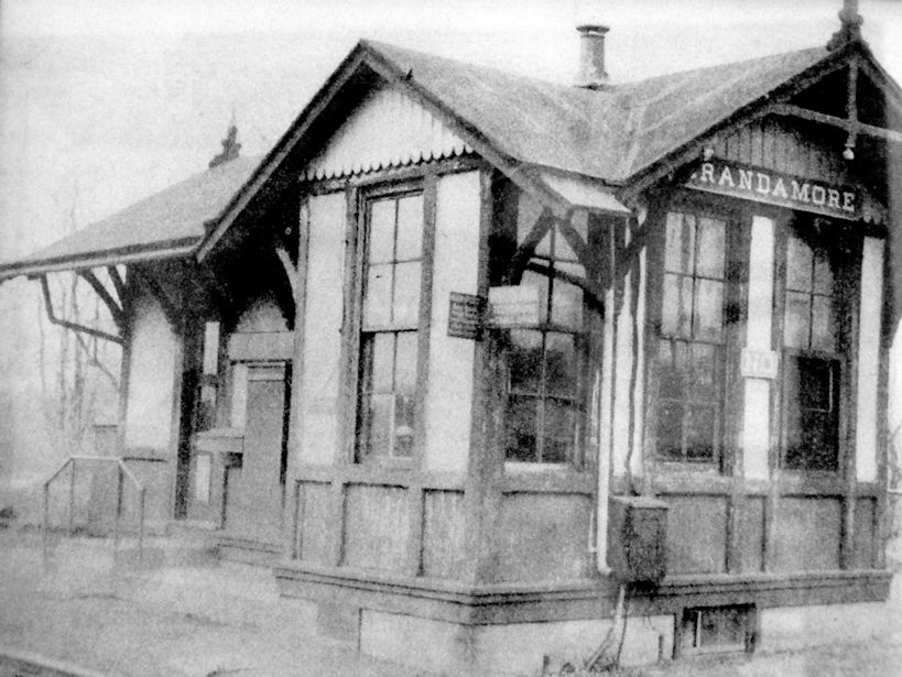
| Brandamore |
|
|||||||
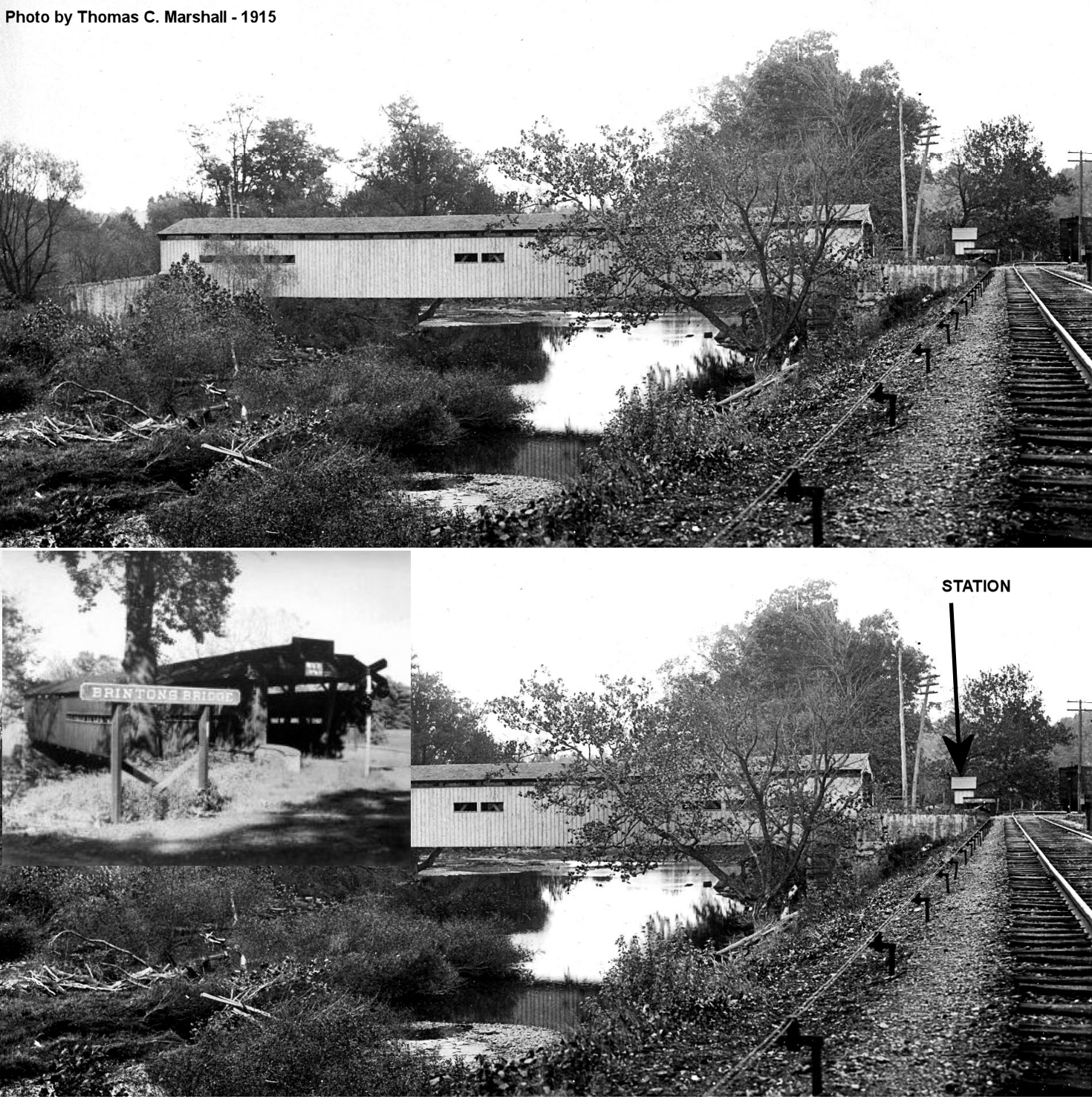
| Brinton's Bridge |
|
This was the first station north of Chadds Ford Junction. There was a small flag-stop shelter here on the NE side of the tracks on Brinton's Bridge Road near the south entrance to the bridge (now gone) at approximately GPS: 39.883718, -75.608770. The bridge was named after Brinton King. | ||||||
| Broad Run Station |
 |
This Delaware & Western RR station is shown on the 1883 map, but its exact location is not indicated. It was in southern part of New Garden Township SE of Landenberg. | ||||||
| Brookfield |
|
This station was between Chadd's Ford Junction and Cossart. | ||||||
| Brooklyn (Lyndell) |
|
This was a station on the East Brandywine & Waynesburg RR. It was renamed Lyndell in 1900. | ||||||
| Buchanon Road Station |
|
This was an early station on the East Brandywine & Waynesburg RR. It was on the south side of Buchanon Road where the tracks crossed there (40.098992, -75.888923). The station appears on the 1873 map, but is not listed on the 1883 map. | ||||||
| Buck Run |
|
|||||||
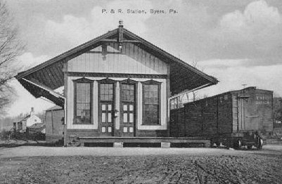
| Byers |
|
|||||||
| Caln |
|
This station was at milepost 33.5 in Caln Township. It was probably at Gallagherville Road and Lincoln Highway. The freight station here was used for loading wood for locomotive power, for supplying water, and for loading ballast from nearby lime/marble quarries. | ||||||
| Camp Station |
|
This was an early station on the PVRR as shown on the 1873 map, but not shown on maps thereafter. It was located neear where the line crossed PA113 at approximately GPS: 40.083868, -75.630053. | ||||||
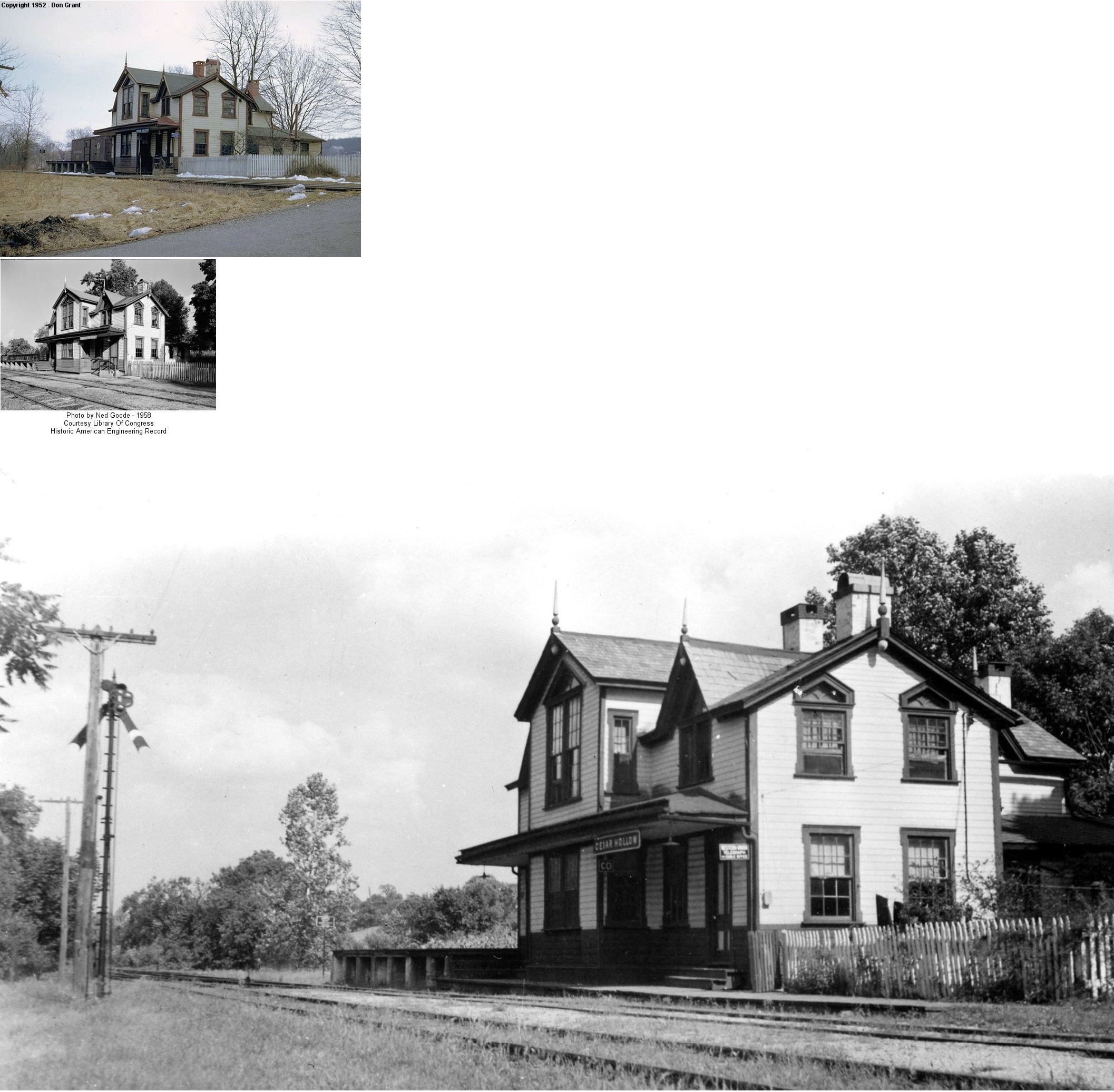
| Cedar Hollow |
|
Sat on the east side of Cedar Hollow Road, one-half mile south of Swedesford Road in Tredyffrin Township. Station was built in 1872. Platform view. The Cedar Hollow RR branched off to the north ending originally at the Cedar Hollow Lime Company. Later the line was extended to Devault. | ||||||
| Cedar Knoll |
|
This station is shown on the 1873 map as Liggett's Station and on the 1883 map as Cedar Knoll Station. | ||||||
| Chadds Ford Junction |
AND |
This passenger station was just a few hundered yards west from the Chadds Ford PRR (P&B Central) station that was just across the creek in Delaware County. It was off of Fairville Road at GPS: 39.868936, -75.596027. | ||||||
| Charlestown |
|
The original station here was on the north side of the raod on the east side of the tracks. | ||||||
| Chesterbrook |
|
There was a shelter here. This station was between Garden and Howellville. | ||||||
| Chester Springs |
|
The station was near the intersection of PA113 and Yellow Springs Road. | ||||||
| Clonmell (Pusey Station) |
|
This original station was on the property of Elizabeth Pusey hence its original name of Pusey Station. This station was on Clonmell-Upland Road in the vicinity of GPS: 39.882358, -75.826402. | ||||||
| Coatesville |
 |
The first station here was likely built in 1834 and a second was built by the PRR in 1858. The PRR purchased the P&C in 1857. The third station (the brick station that is still standing) was built in 1869. | ||||||
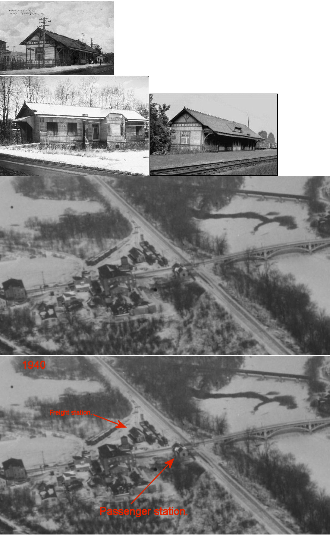
| Coatesville |
|
The freight station was on the south side of the tracks between North 5th Street and North 6th Street at GPS: 39.987094, -75.815101. It was built in 1904 and a two-story headhouse/office was added to the west side of the building in 1909. As of 2025 it appears that the foundation of the building is still there. There was also a loading shed/platform south of the freight station (that may have been the original freight station, but that's just a guess - earlier Sanborn maps don't show this section of town). | ||||||
| Coatesville |
|
The original station here was at the west end of Harmony Street on the east side of the tracks (GPS: 39.982055, -75.824126). Later this served as a freight station when a new brick Reading station was built (see listing below). The station was built around 1867. It is shown as a freight house on the 1921 map, but is gone by 1928 and replaced with a brick and steel freighthouse (see below). | ||||||
| Coatesville |
|
The passenger station was on the NW corner of North 1st Avenue (PA 82) and East Lincoln Highway (Business US 30) (GPS: 39.983236, -75.824341). The station was on the east side of Wilmington & Northern tracks located on the east side of the west branch of the Brandywine Creek. | ||||||
| Coatesville |
|
This brick and steel freight station was built sometime between 1921-28 on the site of the old W&N station. | ||||||
| Conestoga Station |
|
This early station was on Manor Road (PA82) in West Nantmeal Township. It is shown on the 1873 county atlas. | ||||||
| Cornog |
|
This station was in the SE part of Wallace Township on the New Holland Branch. | ||||||
| Cossart (Pyles Station) |
|
An earlier frame station burned down in the earlier 1900s (see notes below for the existing Cossart station). | ||||||
| Coventry |
|
This station opened in 1884 when the railroad was completed between Pottstown and Norristown. | ||||||
| Coventryville |
|
This station was at milepost 9.7 on the Delaware River & Lancaster RR. There were also sidings here that served a nearby graphite mine. | ||||||
| Cromby |
|
This station was just NW of Phoenixville as shown on the 1923 map. It was on the SE side of Township Line Road just south of Cromby Road on the north side of the tracks at approximately GPS: 40.147836, -75.528433. | ||||||
| Cupola Station |
|
This was an early station on the East Brandywine & Waynesburg RR. It was on Chestnut Tree Road south of Cupola Road/Creek Road. | ||||||
| Dampmans Station |
|
This was an early station on the East Brandywine & Waynesburg RR. It was on the south side of the tracks on the west side of Dampman Road. The station is shown on the 1873 maps, but not on subsequent maps. | ||||||
| Daylesford |
|
Was at US 30 and Glen Avenue at GPS: 40.042851, -75.460687. Station was razed in early 2000s. There is a modern SEPTA shelter there now. | ||||||
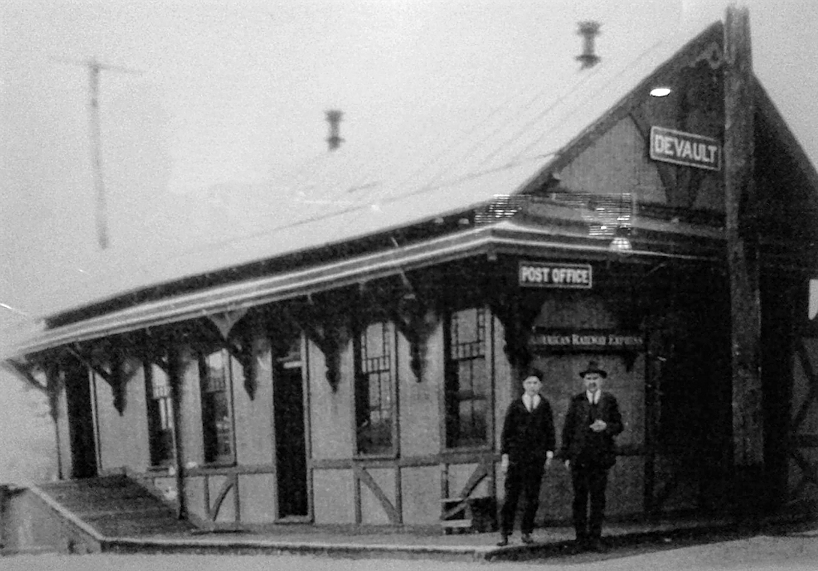
| Devault |
|
This was on the old Phoenxiville & West Chester Railroad line. | ||||||
| Devon |
|
There was an earlier station here that predated the 1890 one that is still standing. The 1883 map shows a station at approximately the same location as the current station. | ||||||
| Doe Run Station |
|
This station was on Doe Run Station Road/Chapel Road at approximately GPS: 39.915723, -75.833175. | ||||||
| Dorlan's Mills Station (Dorlan) |
|
This was a station on the East Brandywine & Waynesburg RR. | ||||||
| Dowlin's Forge Station (Dowlin) |
|
This was a station on the East Brandywine & Waynesburg RR. The station was on Dowlin Forge Road at approximately GPS: 40.035017, -75.708679. | ||||||
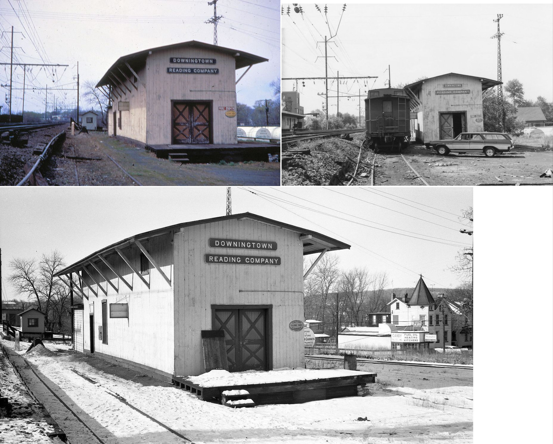
| Downingtown |
|
The first station here was a small frame station on the south side of Lincoln Highway (Lancaster Ave.) on the north side of the tracks (GPS: 40.002216, -75.710600). This station was built in 1862 and is shown on the 1886 Sanborn map. Next to the station was the PRR House hotel. It was torn down around the time the new station was built in 1892. | ||||||
| DowningtoWn |
|
This was the second station here, built in 1892. Prior to it being built here, there was a railroad hotel at this location (there was also one called the PRR House across the tracks). It was torn down after being gutted by fire in February 1992. Until then it was an active Amtrak and SEPTA agency station. In the late 1980s it was even the origin/terminus of an Amtrak Metroliner train to/from Washington DC. There are currently two Amtrak shelters there, but the old foundation is still visible. It was on the north side of Viaduct Avenue on the south side of the tracks at GPS: 40.002011, -75.710353. | ||||||
| DowningtoWn |
|
There was a freight station on the south side of Jefferson Avenue at Beech Street (GPS: 40.004911, -75.701737). It is shown on the 1921 Sanborn map. | ||||||
| DowningtoWn |
|
There was a freight station just NW of the intersection of Viaduct Avenue and St. James Alley (GPS: 40.001516, -75.712099). It is shown on the 1921 Sanborn map. | ||||||
| DowningtoWn |
|
There was a Downingtown & Lancaster RR (formerly East Brandywine & Waynesburg, subsequently the PRR New Holland Branch) freight station on the south side of Washington Street on the west side of the tracks. The station is shown on the 1903 map. It is also shown on the 1921 map, but as a coal and ice company rather than as a freight station. It likely became redundant with the construction of the Jefferson Avenue freight station. | ||||||
| DowningtoWn |
|
This passenger and freight station was on the east side of Brandywine Avenue on the north side of the tracks (GPS: 40.003014, -75.701962). This is also where the PRR New Holland Branch met the PRR main line. The Reading's Phildelphia & Chester Valley RR line ended at this station. This station is mislabeled as a PRR station on the 1921 Sanborn map. | ||||||
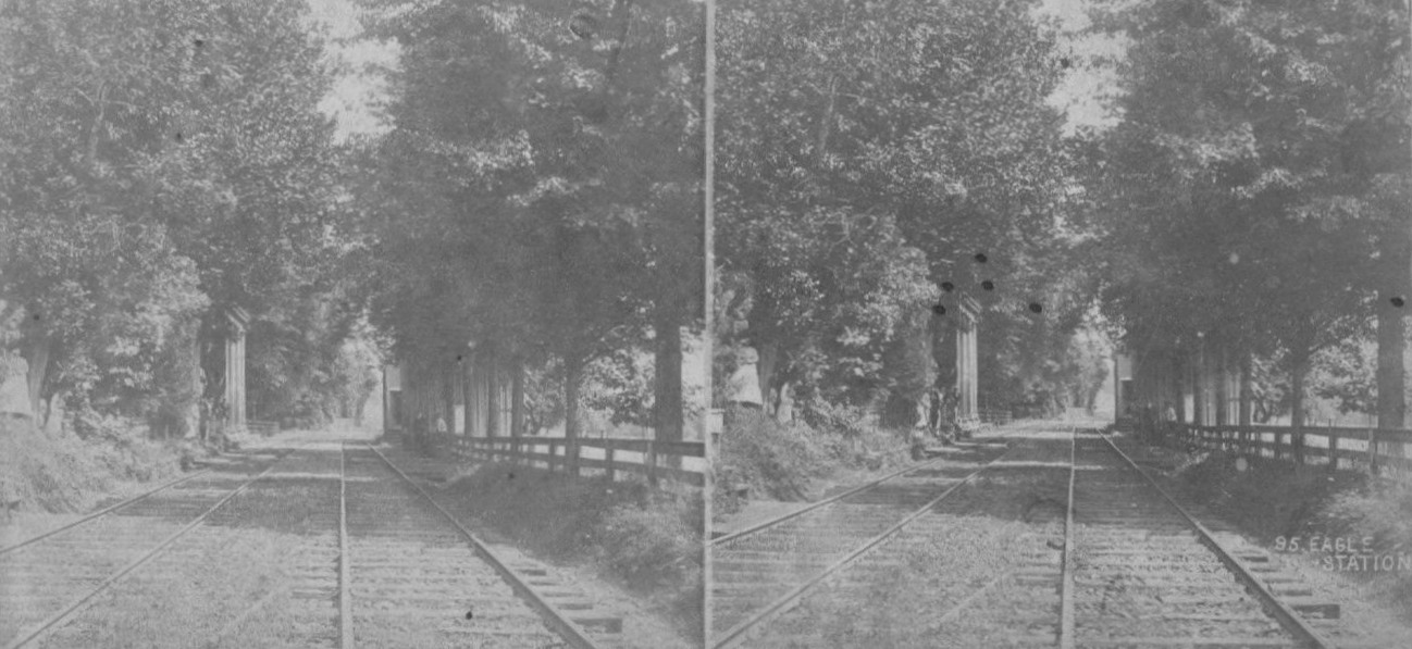
| Eagle Station |
|
See listing below for Strafford. In 1880 the depot at Eagle Station was moved to the Lancaster Avenue crossing from its original location. | ||||||
| Elkview |
|
This station was on the north side of the tracks on the east side of Newark Road (GPS: 39.808312, -75.894916). | ||||||
| Elverson (Springfield) |
|
The town was called Spingfield (Blue Rock P.O.) when the first station was built here. In 1883 the station was on the north side of High Street. | ||||||
| Embreeville Station |
|
A Reading station was built here in 1895. It was on the south side of the tracks on the east side of Embreeville Road (GPS: 39.929911, -75.734004). | ||||||
| Exton |
|
This platform was used to load freight (mostly milk and produce) and sat near the existing Exton Hotel (still standing, see listing above). | ||||||
| Exton |
|
This station, which was two small metal shelters built in 1981, was removed in 2017 upon the construction of the new Amtrak/Septa station. It was located on Walkertown Road, south of the Exton Bypass at GPS: 40.019550, -75.621726. | ||||||
| Ferndale |
|
On the 1873 map, this station is called Honeybrook, but on the 1883 map it is Ferndale. | ||||||
| Fern Hill (McCalls) |
|
Identified as McCall's Station on the 1873 map. It was on the south side of Old Fern Hill Road at approximately GPS: 39.979017, -75.591338. | ||||||
| Fontaine (Long's Station) |
|
This station is shown on the 1873 and 1883 as Long's Station as it was on the property of Mary Long. It was on the south side of White School Road in the vicinity of GPS: 40.119683, -75.864692. | ||||||
| Forrest Station |
|
This was an early station on the East Brandywine & Waynesburg RR. It was on the south side of the tracks on the west side of Forrest Road. The station is shown on the 1873 maps, but not on subsequent maps. | ||||||
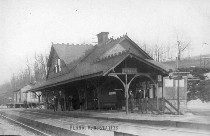
| Frazer |
|
This station was on the east side of Sproul Road (PA352) on the south side of the tracks at approximately GPS: 40.034171, -75.557083. A new station was built here in 1886 (not sure if that is the one pictured). | ||||||
| French Creek Falls - St. Peters |
|
This station was at milepost 11.7 on the Delaware River & Lancaster RR. | ||||||
| French Creek Junction |
|
This was the beginning of the Delaware River & Lancaster RR at its junction with the Pickerington Valley RR near Kimberton. This was milepost 0 on the line which was known loaclly as the "Sowbelly Railroad." | ||||||
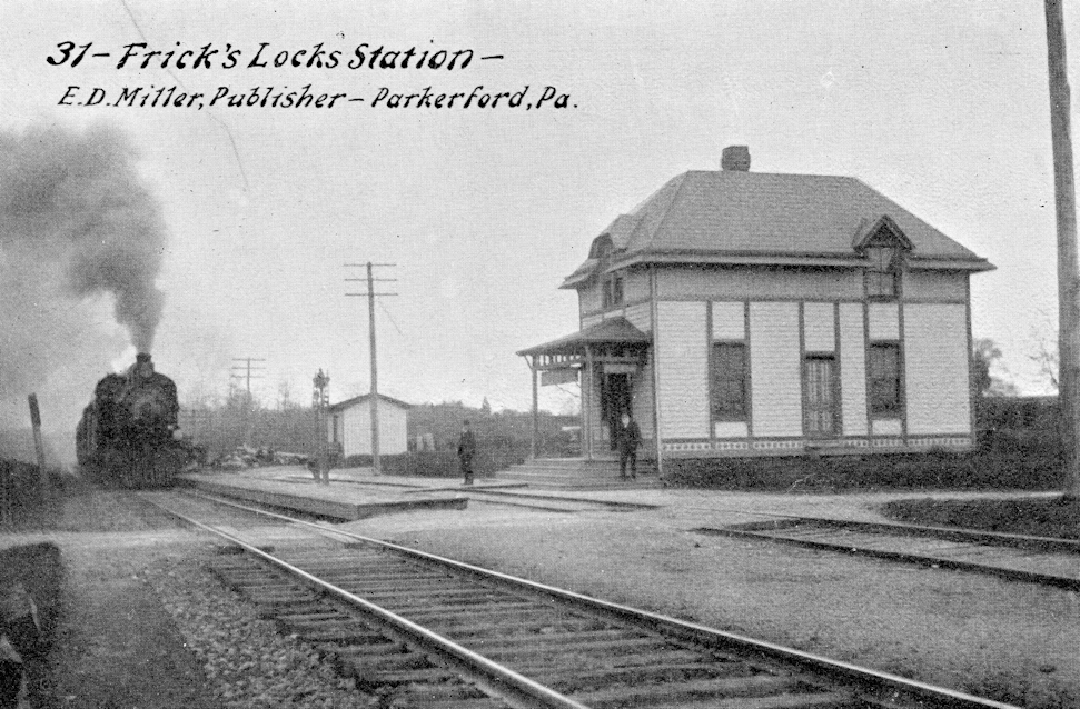
| Frick's Lock |
|
This station was built in 1884 and burned down in 1938. | ||||||
| Gallagherville |
|
|||||||
| Garden |
|
This station was on the west side of Valley Forge Road at approximately GPS: 40.070496, -75.436478. | ||||||
| Gibralter |
|
This station was supposedly on the French Creek Branch (as identified in Benjamin Bernhart's "Reading RR Station Pictorial). Does anyone know where this station was? It is not on the 1883 or 1923 maps. | ||||||
| Glen Hall (Hall's Station) |
|
|||||||
| Glen Rose |
|
See entry below for Newlin. | ||||||
| GlenLoch |
|
The early station here was called "Steamboat" with the name being changed to Glenloch in 1872. | ||||||
| GlenMoore (Moorestown) |
|
In 1873, when the town was known as Moorestown, the ticket office was in the hotel. The PRR built its station on Park Lane off Creek Road (PA282) in 1890. | ||||||
| Green Hill (Patton Station) |
|
Identified as Patton Station on the 1873 map, the station's name was changed by the PRR in 1880. It was on Green Hill Road. | ||||||
| Green Lawn |
|
This station was on Green Lawn Road at approximately GPS: 39.887840, -75.842126. It is not shown on the early maps, but does appear on the 1912 map. | ||||||
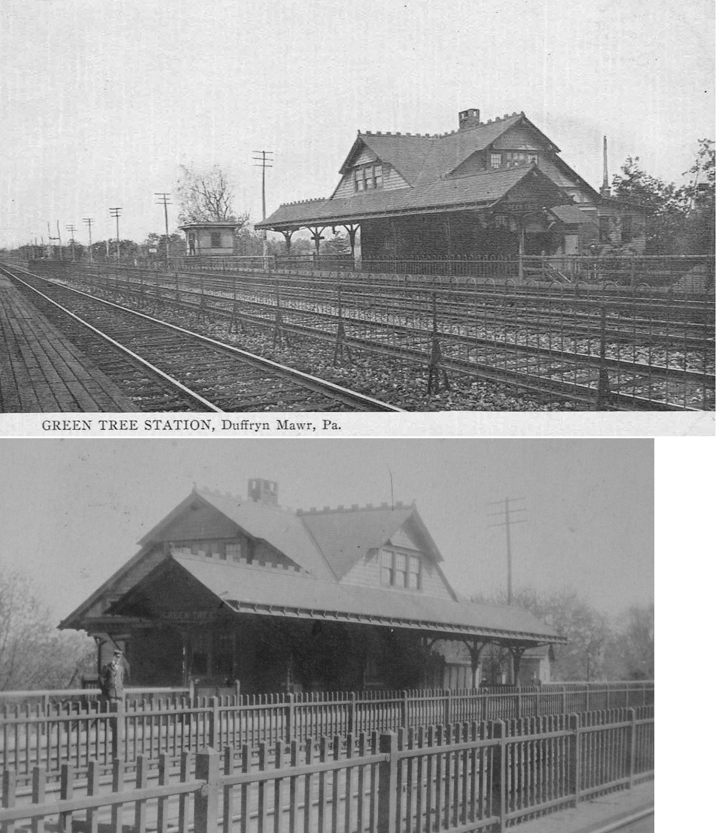
| Green Tree (Duffryn Mawr) |
|
This station was where Old Lincoln Highway used to cross the tracks to the east of Malvern. A new station was built here in 1886 and the name was changed from "Duffryn Mawr" to "Green Tree" soon after. | ||||||
| Hallman's Station |
|
Previously known as Hartman's Station. | ||||||
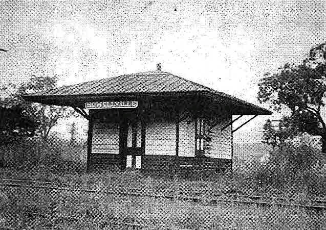
| Harveyville |
|
|||||||
| Hemphills |
|
See listing for Oakbourne below. | ||||||
| Hibernia Station |
|
This station is shown on the 1873 map, but is gone by the 1888 map. | ||||||
| Hiestand |
|
This station was at milepost 0.5 on the Delaware River & Lancaster RR. | ||||||
| Hood Road |
|
In 1880, the new line opened on the West Chester Railroad between Frazer and Woodland (Morstein) and the old alignment between Malvern and Woodland was abandoned. The stations at Summit, Ton Road and Hoods Road were abandoned. | ||||||
| Hopewell |
|
There was a passenger and a freight station here. The freight house was built in 1882. | ||||||
| Howellville |
|
|||||||
| Icedale |
|
This shelter was built in 1897. | ||||||
| Immaculata (Villa Maria) |
|
This station served Immaculata College. Prior to 1929 the college, and station, were known as Villa Maria. | ||||||
| Iron Sides (French Creek) |
|
This station was also known as French Creek Junction and West Phoenixville for short periods. The original name was French Creek Station. It was near the intersection of Township Line Road and PA23 in the vicinity of GPS: 40.133941, -75.540807. | ||||||
| Isabella |
|
This shelter/flag stop station was on Isabella Road at approximately GPS: 40.120758, -75.838048. A station was here as early as 1873. | ||||||
| Kelton (Penn Station) |
|
The first station here was on the south side of the tracks on the east side of Jennersville Road (PA796) (GPS: 39.809085, -75.877538). The second station here was on the north side of the tracks (according to the 1923 map). | ||||||
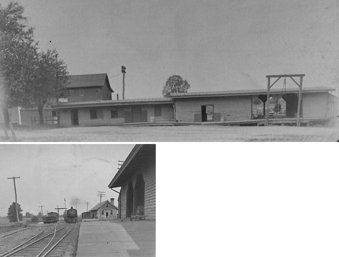
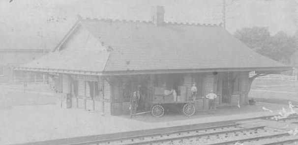
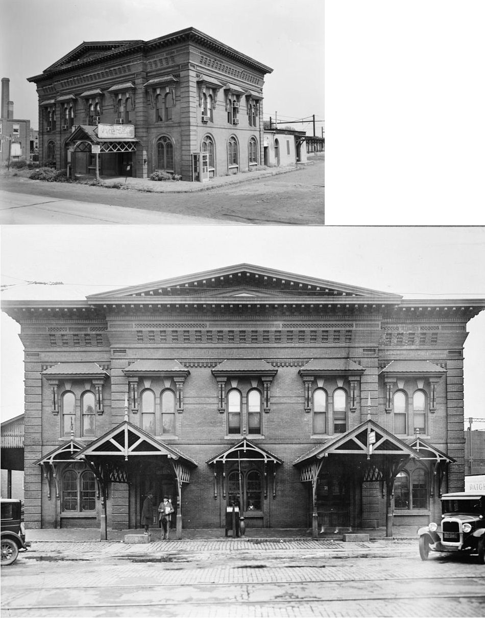
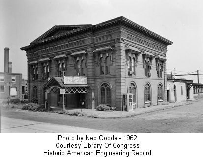
| Kennett Square |
|
The first stations here were on the east side of South Broad Street with the freight station on the north side of the tracks and the passenger station on the south side of the tracks. These Phildelphia & Baltimore Central stations are shown on the 1873 and 1883 maps. | ||||||
| Kennett Square |
|
The passenger station here was on the east side of South Broad street on the north side of the tracks (GPS: 39.842522, -75.708985) in front of the still-standing freight station. The photo shows both stations. The passenger station was torn down in 1949, but the freight station is still standing (as of 2024). | ||||||
| Kimberton |
|
There was a frame station here that predated the brick RDG station. It was built in 1869 and burned down in 1917. | ||||||
| Knauertown |
|
This station was at milepost 10.8 on the Delaware River & Lancaster RR. | ||||||
| Knickerbocker |
|
This station was on the Trenton Cutoff at MP 3.2 between Glen Loch (MP 0) and King of Prussia (MP 11.5). | ||||||
| Landenberg |
AND |
Landenberg was the terminus of the Delaware & Western RR (later owned by the B&O). | ||||||
| Laurel Station |
|
|||||||
| Lee's Station |
|
The original station here was on a private road, but then was moved to a more publically accessible location about a half mile away in 1869. The station was in the vicinity of South Morehall Road near GPS: 40.048509, -75.524694. | ||||||
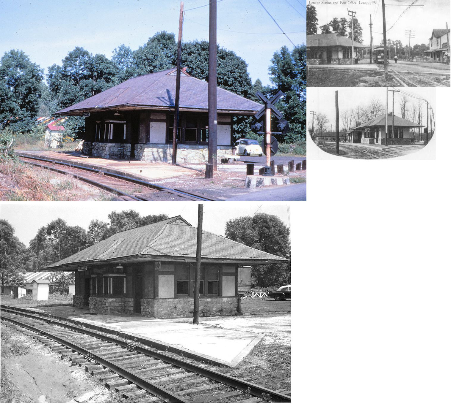
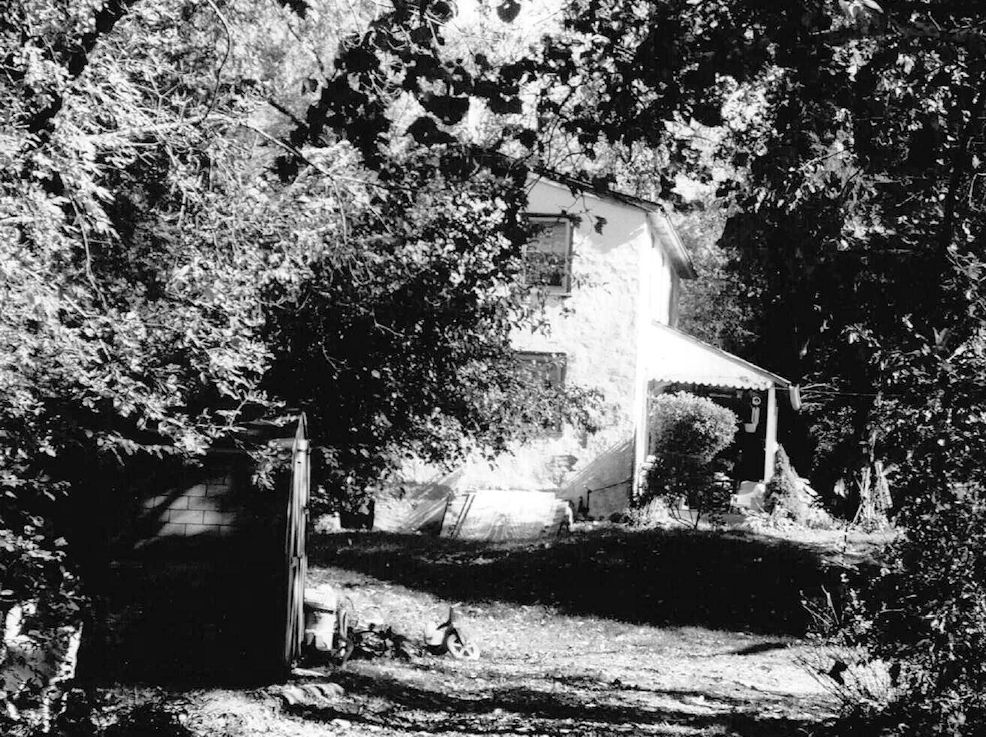
| Lenape (Sagerville) |
|
The original Wilmington & Northern station here was known as Sagerville Station as shown on the 1873 map. | ||||||
| Lenape |
|
This station was built in 1910 or 1911 after the earlier station here burned down (Harrisburg Daily Independent, 9-24-1910). | ||||||
| Lenover (Chalfont) |
|
This station was between Atglen and Parkesburg. It was formerly known as "Chalfont Station" until 1887. The name was probably changed to avoid confusion with Chalfont in Bucks County. | ||||||
| Lewis Mills |
|
This station was on Lewis Mills Road. | ||||||
| Lionville Station |
|
This station was near the intersection of Lionville Station Road and Byers Road near the West Pikeland Township line. | ||||||
| Lyndell |
|
See entry for Brooklyn above. | ||||||
| Malin Station |
|
This station is shown on the 1923 map between Mill Lane and Valley Store. It was on Malin Station Road at West Swedesford Road (GPS: 40.049570, -75.536273). The station was located on a large property which was sold, bought by a developer, and subdivided. It was a farm many years ago, and included the main farm house, a barn, Malin Station, and a couple of tenant houses. The tenant houses were razed. The barn and the train station were both demolished down to their foundations, which remain today (2015). The old farm house was restored and is now a residence. | ||||||
| Malvern |
|
A new station was built here in 1859. At the time this station was known as West Chester Intersection. | ||||||
| Malvern |
|
A second-generation station was built here in 1873. | ||||||
| Malvern |
|
A third-generation station was built here in 1893. | ||||||
| Malvern |
|
The freight station was SW of the passenger station on the south side of the tracks at GPS: 40.036014, -75.516948. It is shown on the 1925 Sanborn map. | ||||||
| Manor Station (Brandywine Manor) |
|
This station is shown on the 1873 map, but not on the 1883 map. | ||||||
| Mc Calls |
|
See entry for Fern Hill above. | ||||||
| Mc Canna Sta. (North Bend) |
|
This station, formerly known as North Bend, was on the south side of the curve between Atglen and Christiana just over the county line in Chester County at approximately GPS: 39.949072, -75.988815. The 5-acre property there was owned by William McCanna who operated a large warehouse there. The warehouse was three stories, made of stone, with a slate roof. It was most likely only a freight stop as it was a receiving point for pig iron (also grain and other freight) which was then hauld by wagon to Goodman's Forge a few miles away. The warehouse was put up for sale in 1879 (Intelligencer Journal, 10-6-1879). | ||||||
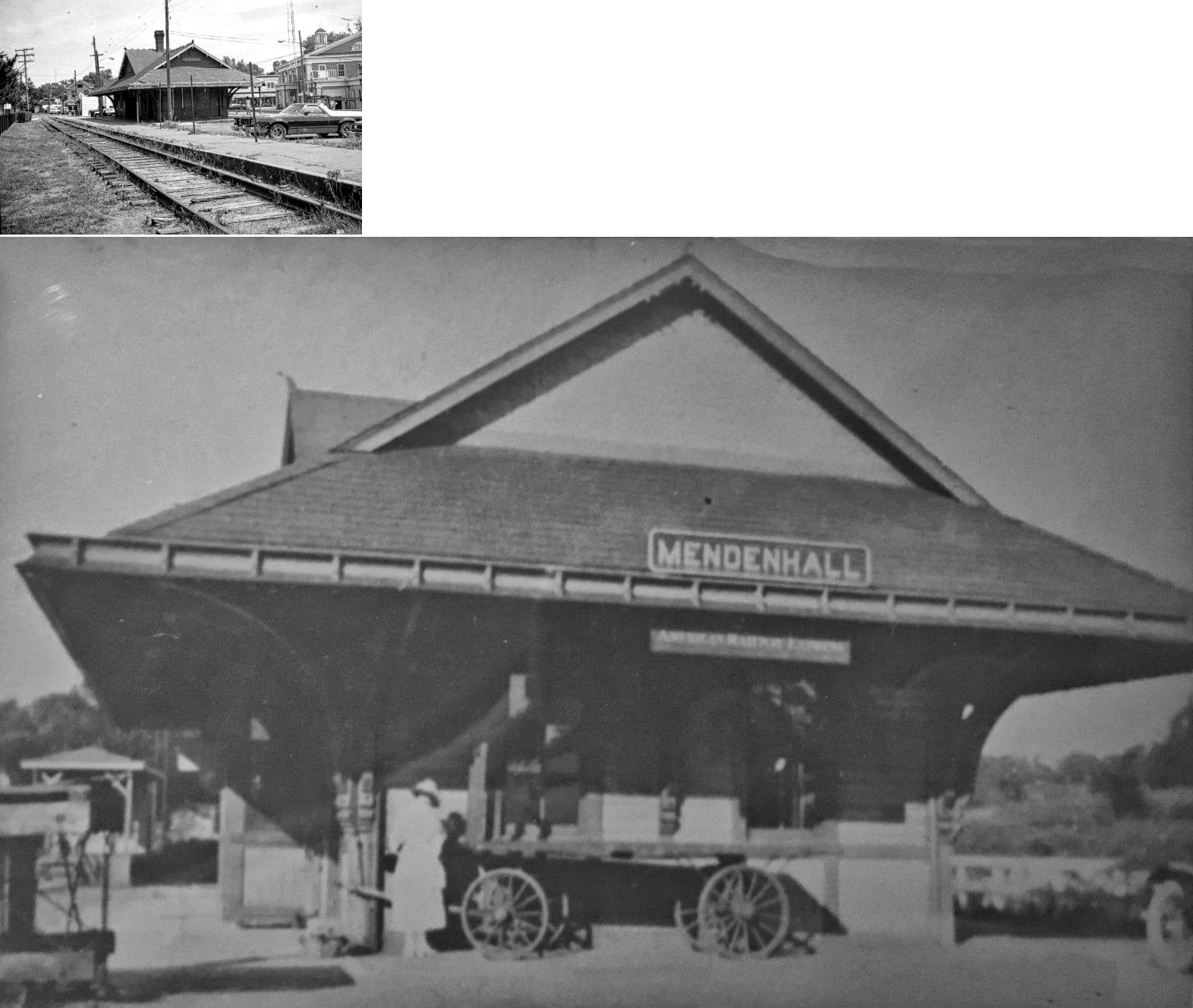
| Mendenhall (Fairville Station) |
|
The early station here was known as Fairville Station (as shown on the 1873 and 1883 maps). It was on the south side of the tracks on the west side of Kennett Pike (GPS: 39.853695, -75.641326). | ||||||
| mODENA |
|
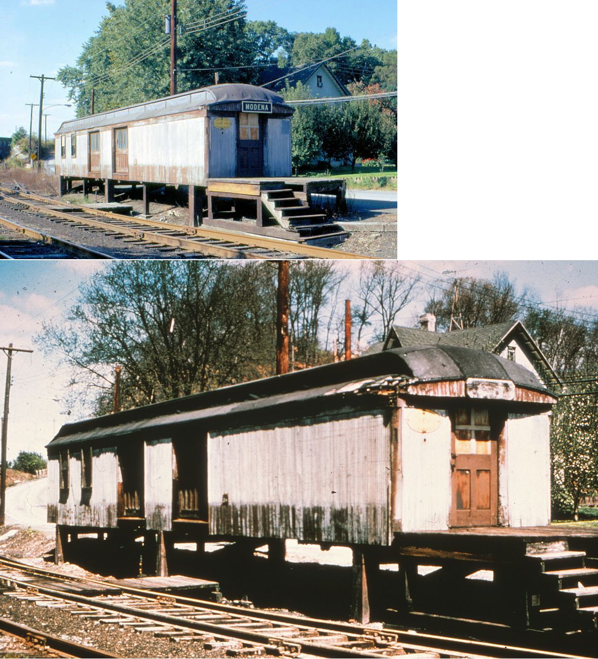
The original station, which was likely aslo a general store, still stands in Modena. Later, the RDG built a smaller station next to the original station at GPS: 39.962935, -75.801251. | ||||||
| Modena |
 |
This old baggage or mail car served as a replacement station during the late 60s/early70s. It was located on the north side of the tracks on Modena Road at GPS: 39.963148, -75.801561. The photo is from 1971. | ||||||
| Mortonville |
|
This station was on Strasburg Road on the west side of the West Branch of Brandywine Creek at GPS: 39.946545, -75.780015. | ||||||
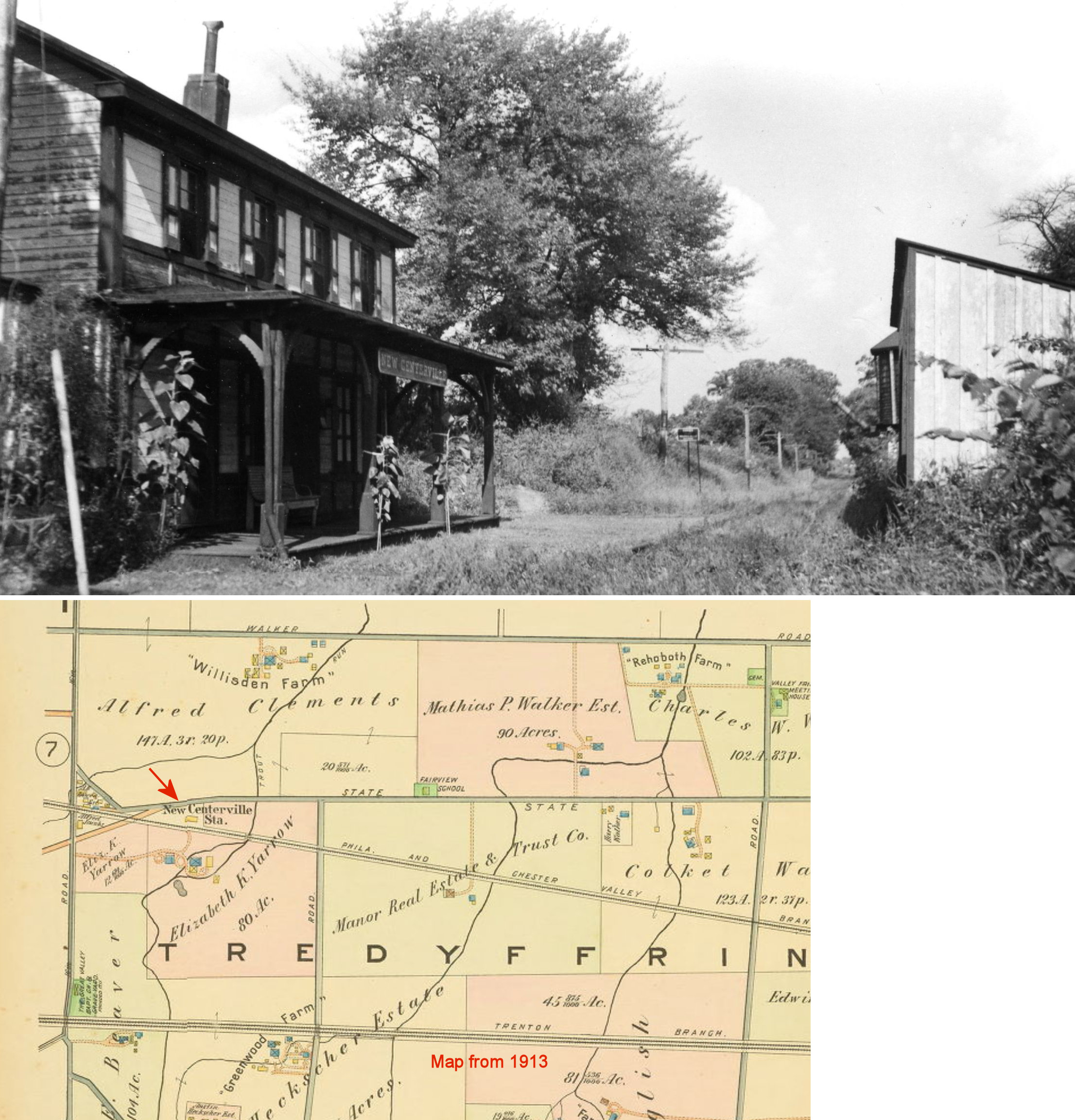
| New Centerville (Centerville Sta.) |
|
This early station was shown on the 1873 and 1883 maps. On the 1933 map the station was on the south side of Swedesford Road on the north side of the tracks at approximately GPS: 40.071294, -75.433766. | ||||||
| New Garden (Southampton) |
|
This station was on Garden Station Road at approximately GPS: 39.803586, -75.782150. | ||||||
| Newlin (Glen Rose) |
|
This station was on the western border of East Fallowfield Township. The station was renamed Glen Rose in 1912. | ||||||
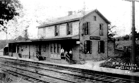
| Nottingham |
|
The station was on the west side of the tracks on the south side of East Christine Road (PA 272) at approximately GPS: 39.748129, -76.016975. | ||||||
| Oakbourne (Hemphills Sta.) |
|
This station was on Oakbourne Road near South Concord Road at approximately GPS: 39.942155, -75.572297. It's original name was Lecompton and then become known as Hemphills Station. It is shown as Hemphills on the 1873 and 1883 maps. An agent (Chalkley Speakman) was listed for the station as early as 1868, so it was standing then. It was likely torn down in the 1960s. | ||||||
| Oakland Station |
|
This station was on South Whitford Road at approximately GPS: 40.020474, -75.641691. | ||||||
| Old Road Station |
|
This station is shown on the 1873 map. | ||||||
| Oxford |
AND |
The original Philadelhia, Baltimore & Washigton combination passenger/freight station here was on the NW side of Railroad Avenue on the SE side of the tracks. (GPS: 39.784784, -75.977106). In the early years the passenger station had a freight house attached to it (in 1886), but later that freight house is gone (1884). Sanborn maps indicate that this station was later shared by the PRR and the LO&S. This old station appears on the 1900 map, but is gone on the 1904 map and replaced by the new station across the tracks in 1902. | ||||||
| Oxford |
|
There was a freight station on the east side of Third Avenue south of Hodgson Street (GPS: 39.781251, -75.979738). It was destroyed by fire on April 30, 1905 according the the York Daily (5/1/1905). Ten freight cars were also destroyed in the blaze. | ||||||
| Oxford |
|
There was a freight station south of the intersection of South Street and Commerce Street (GPS: 39.778564, -75.979635). | ||||||
| Paoli |
|
This station was at the same location as the newer existing station on the east side of North Valley Road near U.S. 30 (GPS: 40.042840, -75.483649). It was built in 1883. | ||||||
| PAOLI |
|
The freight station was on the west side of North Valley Road on the north side of the tracks. | ||||||
| Paoli Road |
|
This was a 10' x 10' shelter. | ||||||
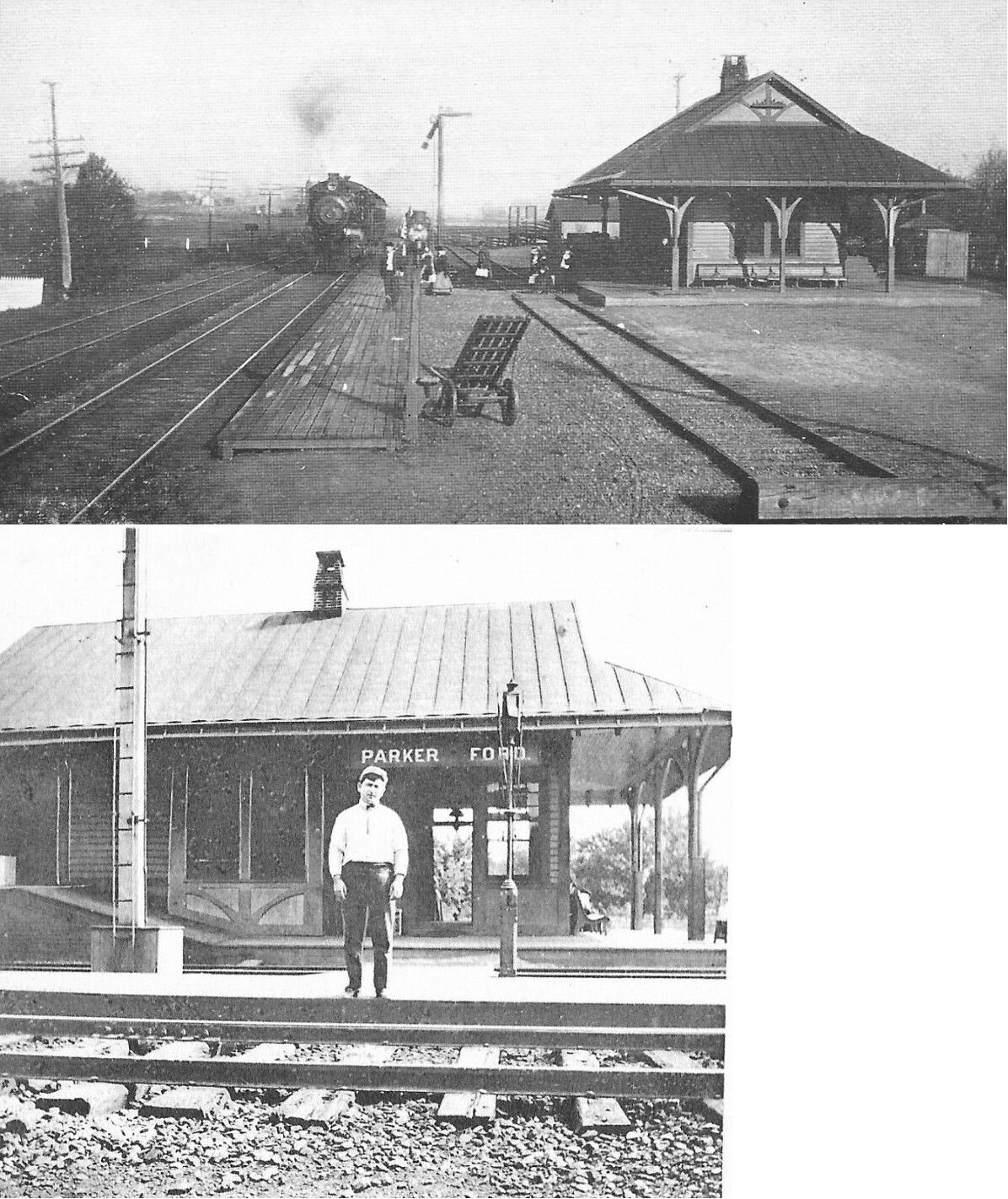
| Parker Ford |
|
This station was built 1884 and demolished 1968. It was near the west end of Linfield Road at GPS: 40.200522, -75.583786. | ||||||
| Parkesburg |
|
A new brick station opened here in 1897. | ||||||
| Parkesburg |
|
There was a brick freight station on the north side of the tracks on the west side of where Brandt Street used to cross the tracks (GPS: 39.960866, -75.916405). This may have been the original passenger station, but that's uncertain. | ||||||
| Pennhhurst |
|
This shelter station was at the base of Crab Hill, which is on the estate of the Pennhurst State Hospital in Spring City. It was near the PennDot facilities that are presently there in the vicinity of GPS: 40.192449, -75.553325. 40.131116, -75.839648. | ||||||
| Perkins Run Sta. |
|
This was an early station that was just north of Isabella. It is shown on the 1873 map, but not on maps thereafter. It was on Chestnut Tree Road in the general vicinity of GPS: 40.131116, -75.839648. | ||||||
| Perkiomen Junction |
 |
As shown on the 1873 map, the original station here was on the east side of the Perkiomen RR tracks around GPS: 40.118123, -75.470489. | ||||||
| Perkiomen Junction |
|
This station was built in 1912. | ||||||
| Phoenixville |
|
This station was on Main Street on the south side of the tracks at GPS: 40.136872, -75.516362. This station is shown on the 1883 map and opened the same year. | ||||||
| Phoenixville |
|
This station was on Vanderslice Street west of the Gay Street bridge (GPS: 40.136737, -75.518922). It was torn down in the late 1980s. | ||||||
| Phoenixville |
|
This freight station was 437 Bridge Street (GPS: 40.131261, -75.522506). It was torn down in 2021. | ||||||
| Phoenixville (Nutts Ave. Sta.) |
|
This small depot or shelter was on the NW side of the tracks between Nutt Road (formerly Nutts Avenue) and Pennsylvania Avenue (GPS: 40.130813, -75.534265). This station is shown on the 1921 Sanborn map. | ||||||
| Phoenixville (Nutts Rd. Sta.) |
|
The station is shown on the 1883 county atlas map and was further to the NW of town where the PVRR crossed this road. | ||||||
| Phoenixville |
|
In 1892 a shelter was built for passengers who walked fromt the ticket office at the RDG station over to the PVRR tracks just to the SE of the RDG station. It was located around GPS: 40.133655, -75.508936. This shelter was torn down five years later when it was discovered that the RR did not own the land upon which it was built. The shelter was rebuilt in 1900 after the Phoenixville Iron Works agreed to lease the small piece of land to the RR. Later the Pickering Valley branch had a spur up to the SW side of the RDG station. | ||||||
| Pickering |
|
This station was on the old Phoenxiville & West Chester Railroad line in the northern part of Charlestown Township. | ||||||
| Pikeland |
|
This station was on Pikeland Road. | ||||||
| Planebrook (White Horse) |
|
This station was on the SE side of Phoenixville Pike on the south side of the tracks (GPS: 40.044045, -75.575091). It is labeled as White Horse Station on the 1873 and 1883 maps. | ||||||
| Pocopson |
|
There was an earlier station here as shown on the 1873 map. | ||||||
| Pomeroy |
|
Sat on the Philadelphia-Harrisburg Main Line at MP 42.2 in a wye at the junction of the former Pomeroy and Newark RR, later the PRR Pomeroy branch (abandoned). The station was at approximately GPS: 39.966034, -75.886226. The passenger station was built in 1889. | ||||||
| Pomeroy |
|
The freight house was built in 1877. | ||||||
| Pughtown |
|
This station was at milepost 7.5 on the Delaware River & Lancaster RR. The station was torn down and the wood was used for another building (which is also now gone). | ||||||
| Reed's Road Station |
|
This station was between Dorlan and Brooklyn. | ||||||
| Roberts |
|
This station was at milepost 6.7 on the Delaware River & Lancaster RR. | ||||||
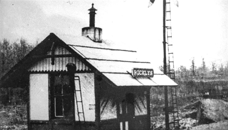
| Rocklyn (Rockville) |
|
The first station here was known as Rockville Station and was on the south side of US-322 on the west side of the tracks according to the 1873 map (GPS: 40.080034, -75.870648). On the 1883 map there is no station at that location, but a new station was built in 1887 and is shown on the 1923 map. The station in the photo was on the north side of US-322 on the west side of the tracks at GPS: 40.080225, -75.870597. | ||||||
| Rokeby |
|
The 1900 PRR List of Stations & Sidings shows a freight station here. It was between Buck Run and Doe Run. | ||||||
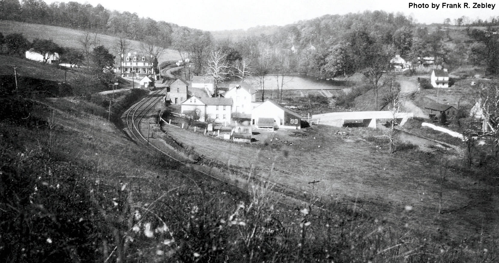
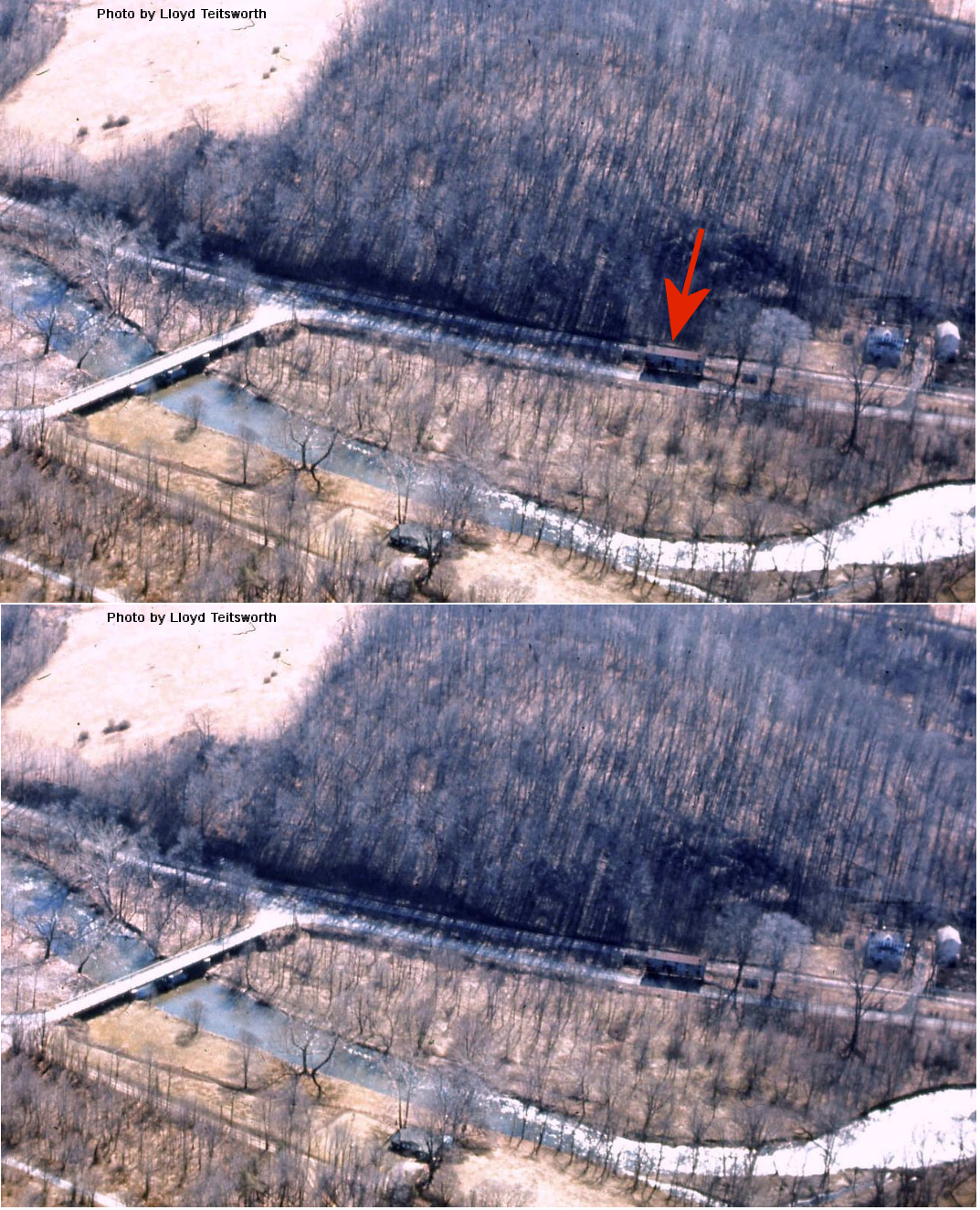
| Rosedale (Norway) |
|
The 1873 map shows passenger and freight stations on the north side of the tracks on the east side of Norway Road (GPS: 39.847587, -75.663334). | ||||||
| Sagerville |
|
|||||||
| Sankanac |
|
Sankanac Station was on the Reading's French Creek Branch (known earlier as the St. Peters Branch). The village of Sankanac was a small company town built by the Pennsylvania Granite Company near the end of 1885. It was located in Warwick Township, just a short distance west of St. Peters Village. The company town of Sankanac was once home to over 500 skilled laborers, the majority of whom were black southerners who had come north from the quarries of Richmond, Virginia. Today, nothing remains of Sankanac other than the quarry pit and perhaps a few gravestones in the cemetery. - Note by Jonathan Hoppe The station was in the general vicinity of GPS: 40.179212, -75.738468. Today that area in inaccessible by road, but the hiking trail may go through there. | ||||||
| Sheeder |
|
This station was at milepost 5.1 on the Delaware River & Lancaster RR. | ||||||
| Ship Road Station (Exton) |
|
This station was on Ship Road at approximately GPS: 40.023308, -75.608605. | ||||||
| Sidley |
|
This station is shown on the 1900 PRR List of Stations & Sidings on the Frazer Branch between Devault and Bacton. | ||||||
| Siousca Station |
|
A new shelter was built here in 1887, but a station is shown here on maps prior to that. | ||||||
| Spring City |
|
This station was on the south side of East Bridge Street on the west side of the tracks (GPS: 40.181946, -75.546113). This station opened in 1884 when the railroad was completed between Pottstown and Norristown. | ||||||
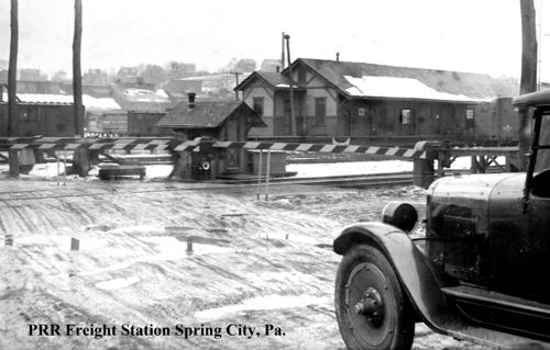
| Spring City |
|
This freight station was across the street from the passenger station. It burned on July 25, 1973 according to the Pottstown Mercury newspaper of that same date. | ||||||
| Springdell |
|
This station was on the north side of Old Hilton Road at approximately GPS: 39.906493, -75.837279. It is shown on the 1923 map. | ||||||
| Springton Station |
|
This was an early station on the East Brandywine & Waynesburg RR. It was located along Creek Road (Route 282) just north of Springton Road in Wallace Township. | ||||||
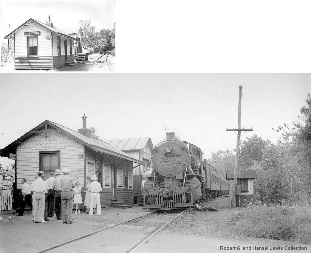
| St. Peters |
|
This station was the terminus of the Reading's French Creek Branch (known earlier as the St. Peters Branch). | ||||||
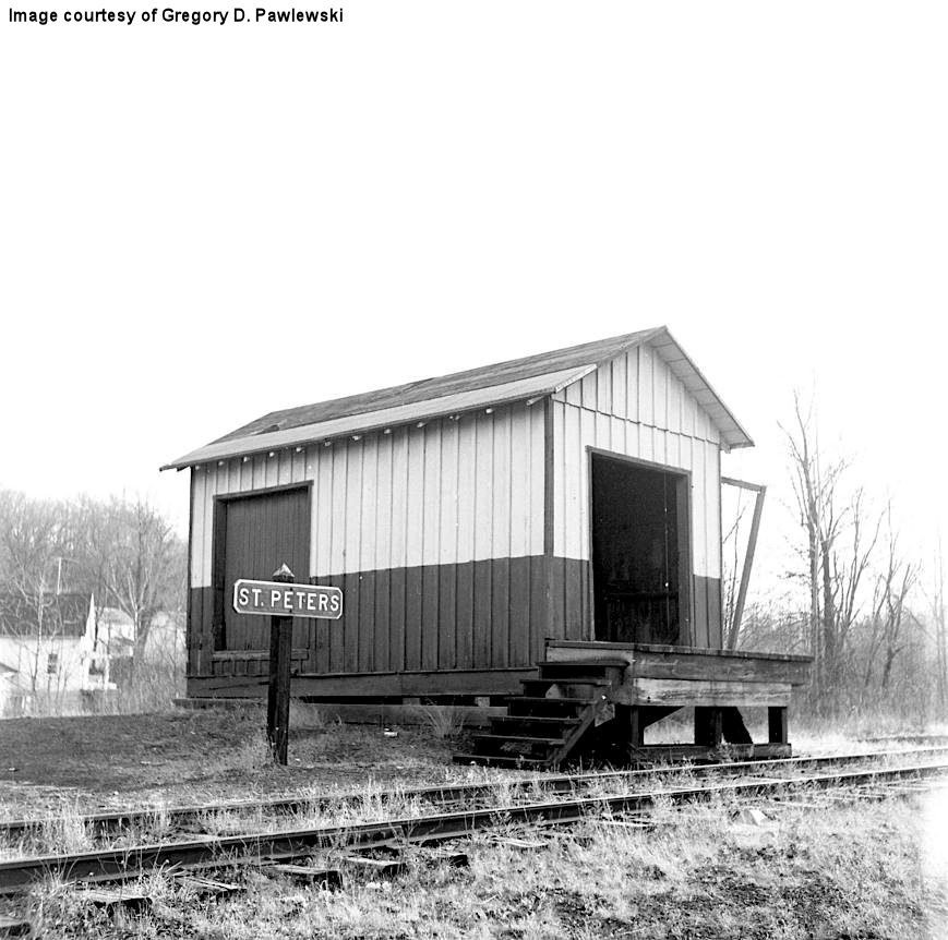
| St. Peters |
|
This was the freight station. | ||||||
| St. Peters |
|
This station was at milepost 12.0 on the Delaware River & Lancaster RR. This was the terminus of the line where it junctioned with the Warwick Branch of the Wilmington & Northern. | ||||||
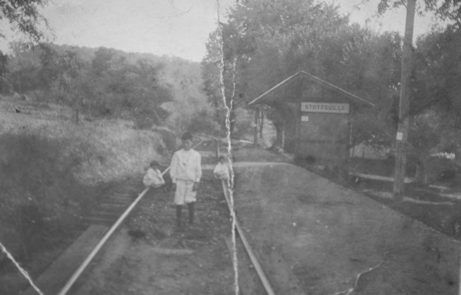
| Stottsville |
|
|||||||
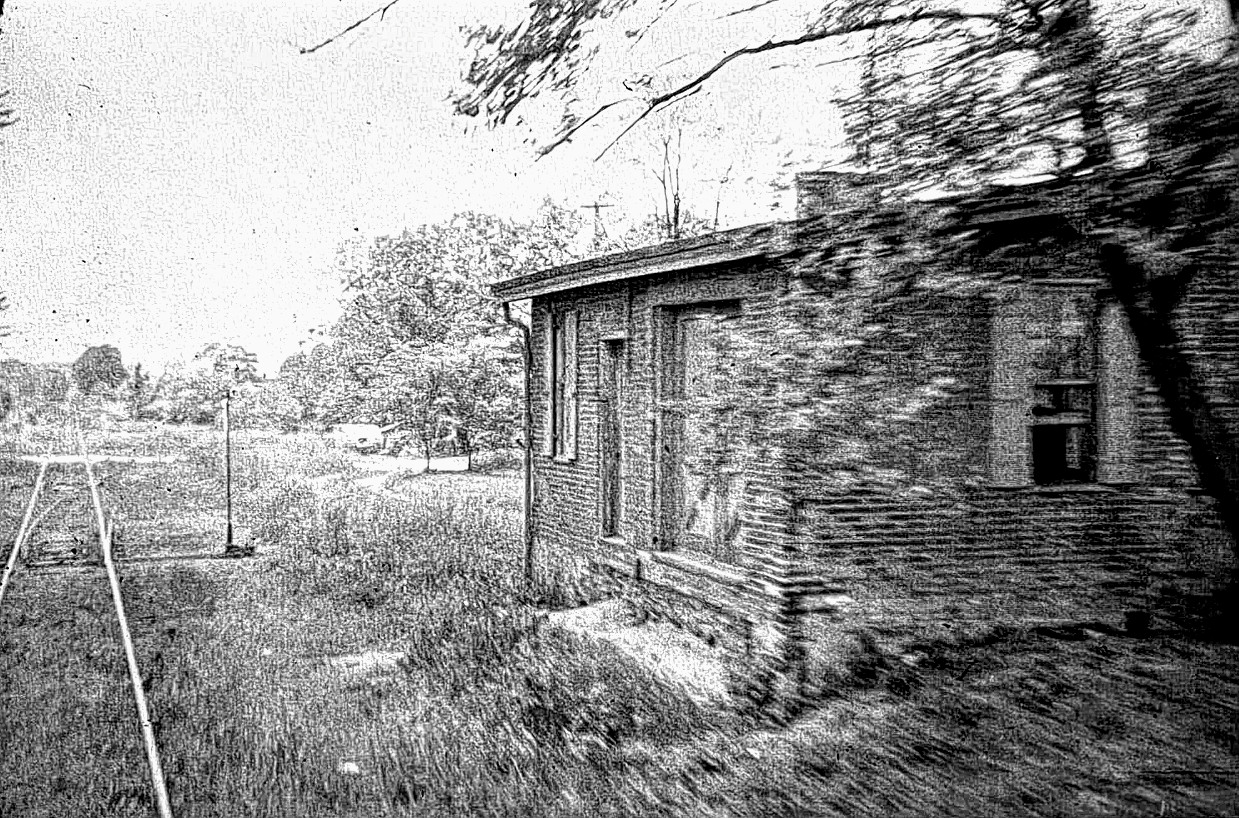
| Strafford (Eagle Station) |
|
Before the newer station was moved in in 1876, the depot here was known as Spead Eagle Station or Eagle Station. It is shown as such on the 1873 map and in fact the 1883 map still had that name as well. The name of the station was officially changed by the PRR in 1887. It was a two-story brick station. It was about 1/3 mile from the existing Strafford station. | ||||||
| Summit Road (Frazer) |
|
In 1880, the new line opened on the West Chester Railroad between Frazer and Woodland (Morstein) and the old alignment between Malvern and Woodland was abandoned. The stations at Summit, Ton Road and Hoods Road were abandoned. | ||||||
| Suplee |
AND |
A station is shown here in the northeast quadrant of the crossing Wilmington & Northern RR and the East Brandywine & Wayesburg RR on the 1873 and 1883 maps. On the 1923 map the Suplee station is shown a bit south of the junction on the W&N. A new station and freight house was built there in 1887. This station was formerly known as Waynesburg Junction on the PRR until 1902 when it was changed to "Suplee." | ||||||
| Swedesford Road Station |
|
This station was near where the Chester Valley RR crossed the Frazer Branch of the PRR near GPS: 40.042137, -75.582182. It is unclear whether it served both railroads at the crossing. | ||||||
| Swedesford Road |
|
This station is shown on the 1900 PRR List of Stations & Sidings on the Frazer Branch. | ||||||
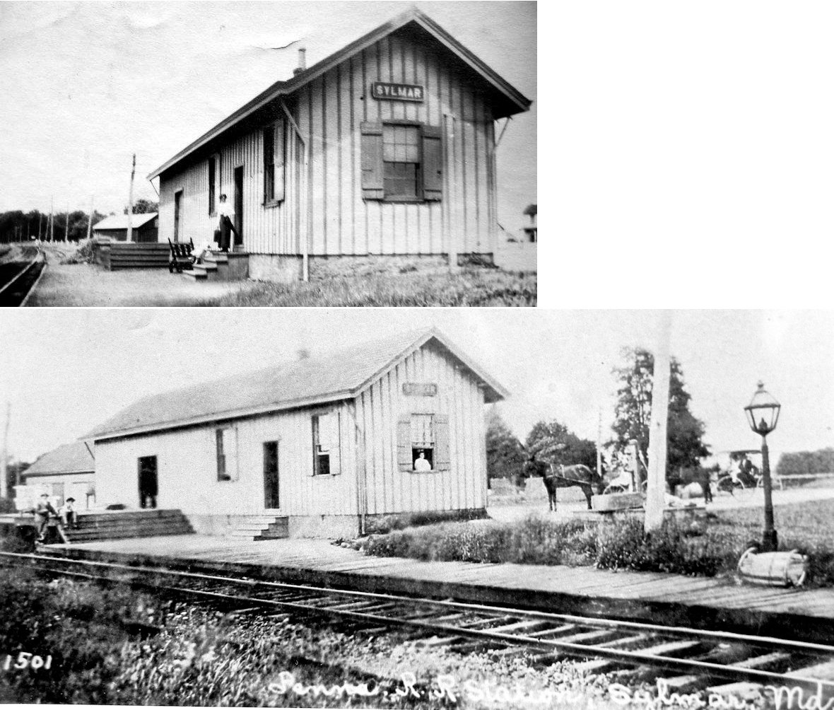
| Sylmar (State Line Sta.) |
|
This station was just north of the Maryland state line on Sylmar Road. | ||||||
| Thorndale |
|
|||||||
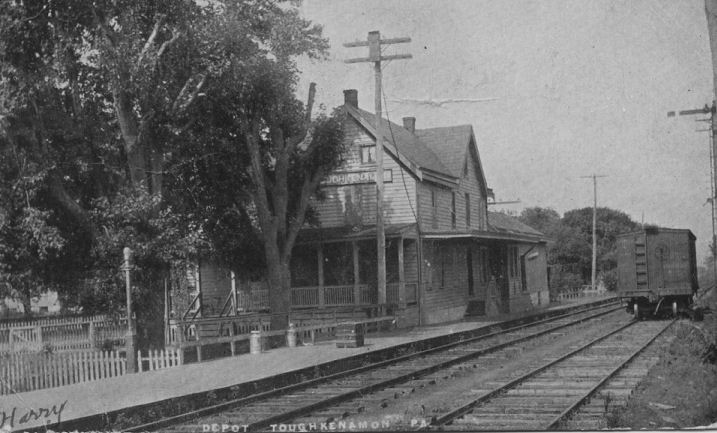
| Toughkenamon |
|
The 1883 map shows the PB&C station on the south side of Main Street on the north side of the tracks at GPS: 39.831276, -75.755950. | ||||||
|
Trytheal (Trythall) |
|
This station was on the Reading's French Creek Branch (known earlier as the St. Peters Branch) on Trythall Road. | ||||||
| Tweedale |
|
|||||||
| Valley Forge | |
The original Valley Forge station was on the river side of the tracks here. | ||||||
| Valley Forge | |
Freight station on the right of the photo, original passenger station on the left. | ||||||
| Valley Forge | |
The second station here was built where the original freight station stood. It served until the stone station was built in 1912. | ||||||
| Valley Station | |
This was likely just a passenger shelter to serve the houses (most are still standing) on Cat's Swamp Row. It was on the east side of Valley Station Road on the north side of the tracks at GPS: 39.994062, -75.826695. | ||||||
| Valley Store |
|
This station was int he vicinity of GPS: 40.048806, -75.529797. | ||||||
| Vincent (Red Hill) |
|
This station was at milepost 4.6 on the Delaware River & Lancaster RR. | ||||||
| Wagontown Station |
|
This station is shown on the 1873 map as Brandywine Station and on the 1883 map as Wagontown Station. | ||||||
| Waler Station |
|
This station was just north of Downingtown in East Caln Township on the East Brandywine & Waynesburg RR. It is shown on the 1873 map, but does not appear on subsequent maps. | ||||||
| Warwick |
|
This station was on the Reading's French Creek Branch (known earlier as the St. Peters Branch). It was located along the west side of PA345 and was a small wooden structure which was removed in the 1970s. | ||||||
|
WaWaset (Seeds Bridge Sta.) |
|
A new station was built here in 1893. The original station was known as Seeds Bridge Station as seen on the 1873 map. The station was gone by 1946. There was a large building there after that, but it was the former coal bins that had been covered by a structure. | ||||||
| West Chester | 
|
Built in 1875, this West Chester & Philadelphia RR (later PRR) station sat on the south side of Market between Matlack and Franklin Streets (GPS: 39.961297, -75.600439). An extension was added in 1917. Originally in 1867, the passenger shed was on the west side of the station and the freight and baggage cars were unloaded on the east side of the station. After through-trains began to operate in West Chester, the passenger shed was moved to the through tracks on the east side and freight was unloaded on the west side of the station, where the Adams Express company had its offices and a warehouse in 1917. Here is a 1962 photo. The station was torn down in 1968. | ||||||
| West Chester |
|
There was a freight house on the corner of Gay and Matlack Streets (GPS: 39.962190, -75.602377). This freight house is shown on the 1891 and was still there in 1921. A larger-looking station is shown here on the 1883 map, but is uncetain if this was the same building or an older station. | ||||||
| West Chester |
|
There was a freight station on the SE side of East Union Street between Franklin Street and Adams Street (GPS: 39.959332, -75.596998). It was partially damaged by fire in July 1944 with only the office portion surviving the blaze (Wilkes-Barre Record, 7/6/1944). Some rolling stock burned and an onlooker collapsed and died from the heat. The remained of the station burned down in 1967. | ||||||
| West Chester (Maple Avenue) |
|
In 1884 a small shelter-type flag stop was opened on Maple Avenue. Old maps don't show where this was exactly. The station was closed in 1917 and replaced with the station listed below. | ||||||
| West Chester (Biddle Street) |
|
This small non-agency station opened in 1917 on the north side of Biddle Street at GPS: 39.966565, -75.600638. This station replaced the Maple Avenue station (see listing above). It appears this station primarily served the Sharples Works and Villa Maria Academy. | ||||||
| West Chester |
|
The earliest station here was a two-story, brick depot built in 1846. It was also later used by the West Chester & Philadelphia RR. (source: James J. D. Lynch Jr., "The West Chester Branch" in THE HIGH LINE, vol. 8, no. 2 & 3, Winter-Spring 1988). The station was retired in 1864, and subsequently used as an office, when the West Chester RR started using the West Chester & Phildelphia RR station. | ||||||
| West Chester |
|
The original freight house here for the West Chester & Philadelphia RR was in the middle of the block bordered by Gay, Chestnut, Walnut and High Streets (GPS: 39.961257, -75.604951). The station is shown on the 1886 map as "Old Freight House (Closed)." It last appeared on the 1902 map as a storage building for machinery. The tracks entered from the north after crossing Chestnut Street. It was built in 1836 and was demolished in 1904. It was moved in 1881 from Gay Street to Franklin Street where it was used as a shed for engine house workers. | ||||||
| West Chester |
|
This concrete station was built in the late 60s/early 70s to replace the old brick station. | ||||||
| West Grove |
|
The first station here was on the east side of Prospect Avenue on the south side of the tracks (GPS: 39.822155, -75.826947). | ||||||
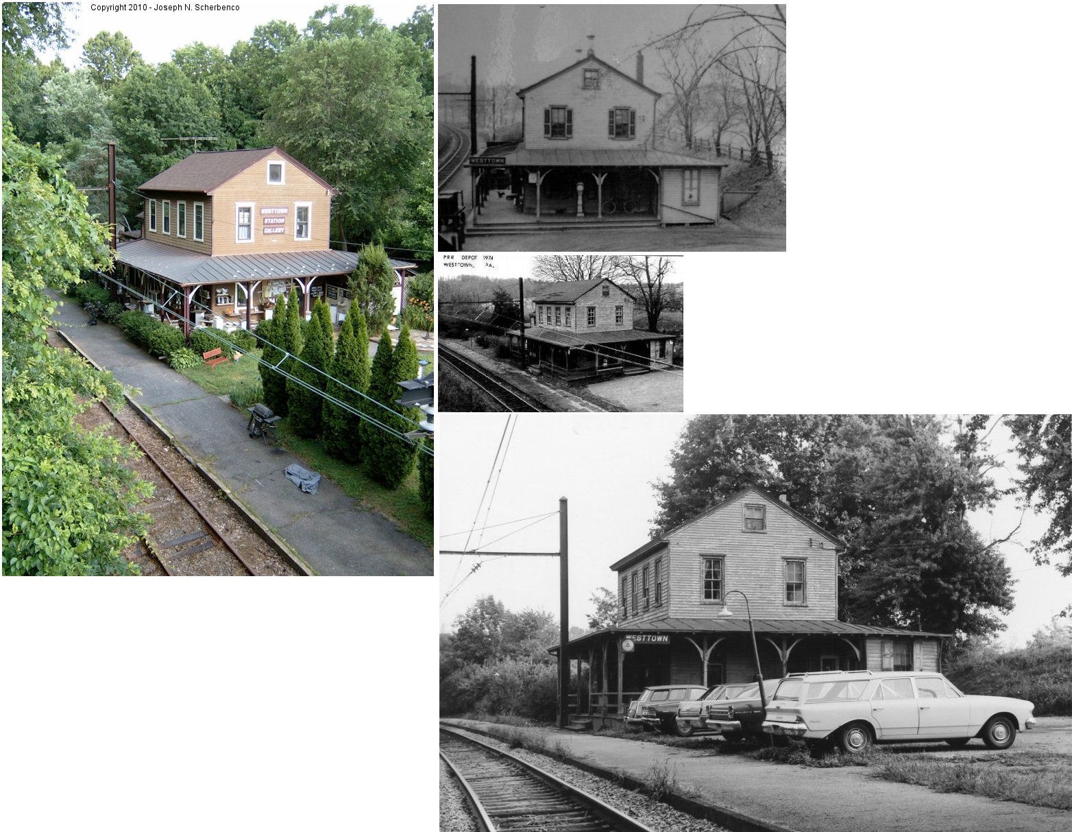
| Westtown (Street Road) |
|
A station was built here in 1858 by the West Chester & Philadelphia RR and the stop was known as Street Road until 1884. The station was on the south side of Street road at approximately GPS: The station primarily served the nearby Westtown Boarding School operated by the Society of Friends. | ||||||
| White Horse Station |
|
See the listing for Planebrook above. | ||||||
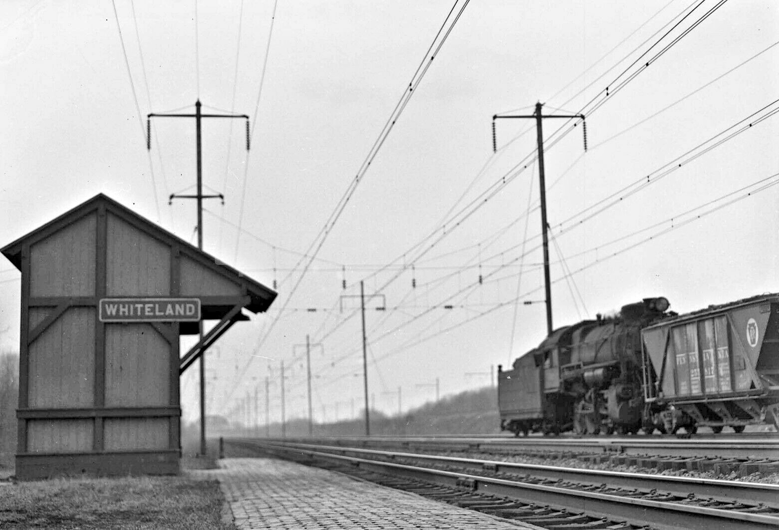
| Whiteland |
|
This shelter-type station was on the east side of Pottstown Pike near where the current Exton Amtrak station is at approximately GPS: 40.036357, -75.515525. | ||||||
| Wilson (Lockarts) |
|
This station was at milepost 3.7 on the Delaware River & Lancaster RR. Station was also known as "Wilson's Corner." | ||||||
| Woodbine |
|
|||||||
| Wyebrook |
|
This station was on Wyebrook Road in the vicinity of GPS: 40.104424, -75.827164. It was built in 1890. | ||||||
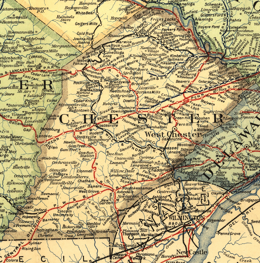
| 1895 CHESTER COUNTY RAILROAD MAP | ||||||||
 |
||||||||
| Notes About Existing
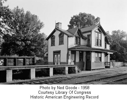
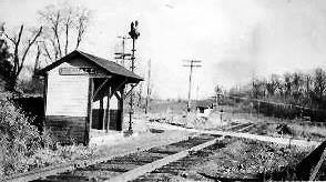
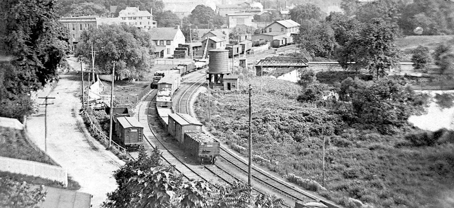
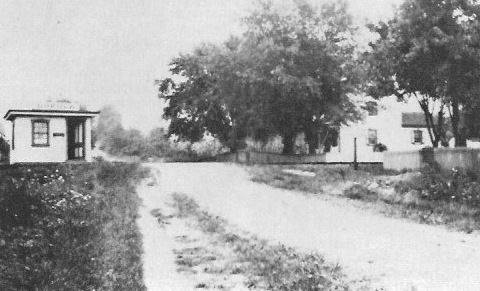
Stations... Avondale (PRR) - This station is on the PRR's Pomeroy and Newark Branch (former Philadelphia and Baltimore Central Railroad) at the former junction with the Octararo Branch. The station had been moved from it’s original location 180 degrees to be along the Octararo Branch, and the upper level was removed in 1946. Berwyn (PRR) - This station is completely different than the other old stations along the "Main Line" between Paoli and Philadelphia in that it is built entirely of red brick, with yellow window and door arches. It is very well maintained and is two stories high. Now a picture frame shop. Buck Run (PRR) - The passenger station had a siding track in front of it that came from the north. Also two siding tracks (with switches across from the station) came across Buck Run Road to the Buck Run Forge. The station was renamed "Buck Run" in 1899. It was previously known as "Gum Tree Station." Chadds Ford Junction (P&B Central/W&N - Freight) - This old freight station was privately owned, but served the railroad here for many years on the interchange track between the P&B Central and Wilmington & Northern. Coatesville (PRR) - First story is at street level (below track level), 2nd story on track level, former 3rd story gable in center of building now gown. When built, the station was set back from tracks to allow for track expansion from 2 to 4 and for track realignments. Eastbound and westbound platform shelters were added in 1909. Level of tracks, platforms and shelters were raised in relationship to the station in the early 1940s during track grade reduction program. Cossart (RDG) - This was the de facto "summit" between Coatesville and Wilmington. In the W&N days it had a small yard and turntable. Trains would be helped from Wilmington to Cossart, then run down grade to Coatesville. The turntable was retired sometime after the W&N was acquired by the P&R. By the diesel era all there was the stone depot on the South/west side of the tracks, a siding and a spur to a coal trestle just north/west of the depot. The coal trestle was about 6 ft high and about 1 or 2 cars long. The depot was a unique design for the Reading. -- Dave Husman. The 1873 map identifies this location as Pyles Station. In the early 1900s, Pyles Station burned down. The property owner of the surrounding farm was HG Haskell. He built the current stone station structure and gave the building to the railroad in the early 1900s (although the book Reading's Victorian Stations (Lewis, 1976) claims it was built in 1929). Trains used to also unload supplies at the adjoining wooden warehouse, now abandoned and in poor condition. When the railroad no longer needed the station (date unknown), it was given/sold back to the Haskell family, which still owns the farmland today (2015). It is now two apartments. Tracks are still maintained by the railroad and active. Devon (PRR) - This station is built in English Tudor style of wood, stucco, brick, stone and terra cotta. Exton (RDG) - The Exton Hotel, formerly known as the Exton House and Ship Station housed the original ticket office for the Chester Valley Railroad at Exton. Glenloch (PRR) - For more info see Tom Young's page about this station. Glenmoore (PRR) - This was likely the first station in Glenmoore (prior to the new station being built in 1890). Some have said it also served as a hotel. On the 1883 atlas, this building is denoted as the depot. The 1873 atlas shows the extant building and the adjacent railroad, though its use is not indicated. I don't see a hotel denoted anywhere in the vicinity on the 1873 or 1883 atlases, but looking at the building with its full 2nd floor it seems plausible that it could have served as such. The extant building denoted as Store & Post Office directly across Creek Road on the atlases could also likely have served as a hotel given its larger size (this c. 1870 mansard roofed Victorian is one of the buildings I suspect may be a Samuel Sloan design). Also note on the current photo of the building from Google Street View that there is a typical bay window at the southwest corner which would have been trackside. What is unclear is whether this building was purpose built as a station at the time of the original construction of the railroad or if it was in existence before the railroad, nor whether it had any official railroad connection after the 1890 station was built. There do not seem to be any pre-1873 atlases for the area available online. Taken as a whole, I believe the evidence indicates that this was the first station at Glenmoore. --Note by Mario Cimino. Isabella (W&N) - This building served as the original station here. When traffic declined in the 1940s a passenger shelter/flag stop was installed across the tracks (see "Stations Of The Past section). The 1873 map of the township shows the station in approximately this location (GPS: 40.121007, -75.837970). Kennett Square (PRR) - This station is used by East Penn Railways. Kirkland Sstation (WC&F) - This station, built between 1860-1879 was moved about 40 feet to its present location in 1880, when the PRR straightened the track at Kirkland. It was later converted to a residence from a ticket/waiting room and station master's home with a small two-story stucco addition (two rooms). The station was placed on the National Historical Register in 1983 by West Whiteland Township. Lincoln University (PB&C) - The railroad was the Philadelphia & Baltimore Central. Burgess and Kennedy's "Centennial History of the Pennsylvania Railroad Company" states that "...the road (P&BC) was completed from Wawa to the Susquehanna River....in 1867..." It is my guess that the railroad was being built past what was to become the village of Lincoln University in 1866, the same year that the school was renamed. The ramshackle remains have been bought by a couple that have the hobby of restoring older structures. --Ed Thornton Mill Lane (PG&N) - Greek-Revival Architecture with roof, center hall and stairway classic of that era (pre-1840), made of stone and stucco, typical of "country house" stations built by the owner; Philadelphia Germantown & Norristown Railroad (but named Norristown Valley Railroad and later changed to Chester Valley Railroad). Windows upgraded later by Philadelphia & Reading RR. The only station left, similar to Shawmont, also built by the PG&N. Other sources, like Bernhart & Bernhart's Reading Railroad Stationn Pictorial, say the station was built in 1914. The realty listing for the house says it was built in 1900. Can someone sort out this discrepancy? Modena (W&N) - This station is pictured on page 85-86 of Reading RR Station Pictorial, Vol. 4 by Benjamin Bernhart. It is the original Modena station. Later the RDG constructed a smaller station building between the original station and the tracks. Morstein (West Chester & Frazer) - Station is located in Exton Station (West Whiteland Twp.). There is no town called Morstein currently, but the station was given this name in 1900, by the Lewis family that lived nearby. It was previously known as "Woodland" and "Zermatt." This is one of the earliest surviving railroad stations. The original station part is built of brick and the wood fram addition was added in 1889 due to increased business at the station. Northbrook (W&N) - This station is built like a clapboard farmhouse, complete with a front porch. At first glance it does not look like a train station, but has served well over 100 years. It currently serves as a house and is located by the Northbrook Canoe Company on the Western Branch of Brandywine Creek. The Brandywine Valley Scenic RR uses the tracks. This location was also known as Marshall's Station in the early years of the railroad (see 1873 county map). Northbrook (W&N Freight) - This appears to (have been) be a freight station, but could use some more confirmation if it is. Paoli (Amtrak) - Although the old 1953 PRR station is still part of this complex, Amtrak essentially built a modern glass/metal/brick station around that building. Parkesburg (PRR) - The station opened on June 4, 1906. This was the furthest westward reach of the SEPTA commuter rail line until 1995 (R5 Paoli/Parkesburg). The town was founded around a repair shop for the Philadelphia and Columbia RR in the 1830's and 40's, and there is a brick railroad structure on the north side about 200 yards east of the station. The station was abandoned for some time but is under renovation. Phoenixville (RDG) - The station was built around 1865 and was remodeled in 1877 when two towers were removed. Passenger traffic ceased about 1980 on this formerly four-track Reading line; now there are only two tracks. Pocopson (W&N) - This station is built of local green serpentine fieldstone and wood shingle. It is superbly maintained as "Pocopson Veterinary Station" and the Brandywine Scenic Railway runs past it. The interior woodwork is preserved and the ticket office is now the examining room. Rosedale (PRR) - The photo is of the freight station here (or part of the old combination station) in the 1950s. This building may still be standing as part of a house here. Need more recent photos and confirmation. Strafford (PRR) - Station was built as the Catalogue Building for the Centennial Exposition in Philadelphia. After the exposition the station was bought at auction by the PRR and moved to Wayne in 1885 and then moved to Strafford in 1887. When the station was moved to Strafford in 1887 some of the ornamentation was removed due to placing the station on a sloping piece of land. Valley Forge (RDG) - This station was built in 1912 to allow visitors to stop at Washington's Headquarters. It is built of fieldstone in colonial revival style, with a gorgeous waiting room, complete with fireplace. The platform roof was held up by doric columns and originally the stairways were ornamented with pyramids of cannonballs! The station has been out of use since the 1970s, and the platform concrete is is poor condition. The two outer tracks have been removed, and the two inner tracks are used for freight. Now owned by the National Park Service and serves as George Washington-centric museum. Westtown (RDG) - The station was built here in 1859 by the West Chester & Philadelphia RR and the stop was known as Street Road until 1888. The station primarily served the nearby Westtown Boarding School operated by the Society of Friends. The station is in Thornberry Township, Chester County which is not to be confused with the adjacent Thornberry Township in Delaware County. Whitford (PRR) - The station building is plain clapboard and is presently boarded up but in fair condition. The freight shed is cut gray "rubble" stone and is probably older than the station; it is now part of a business. Most remarkable is that the station is located under a huge "flyover" girder bridge built in 1902, part of the old "Trenton Cutoff" system. The "high line" is now abandoned, but the main line tracks are still in heavy use. |
||||||||