|
|
||||||||
| EXISTING STATIONS | ||||||||
|---|---|---|---|---|---|---|---|---|
| Station Name |
Original Railroad |
Current Location |
Type | Current Use |
Date Built |
Track Status |
Building Material |
More Info |
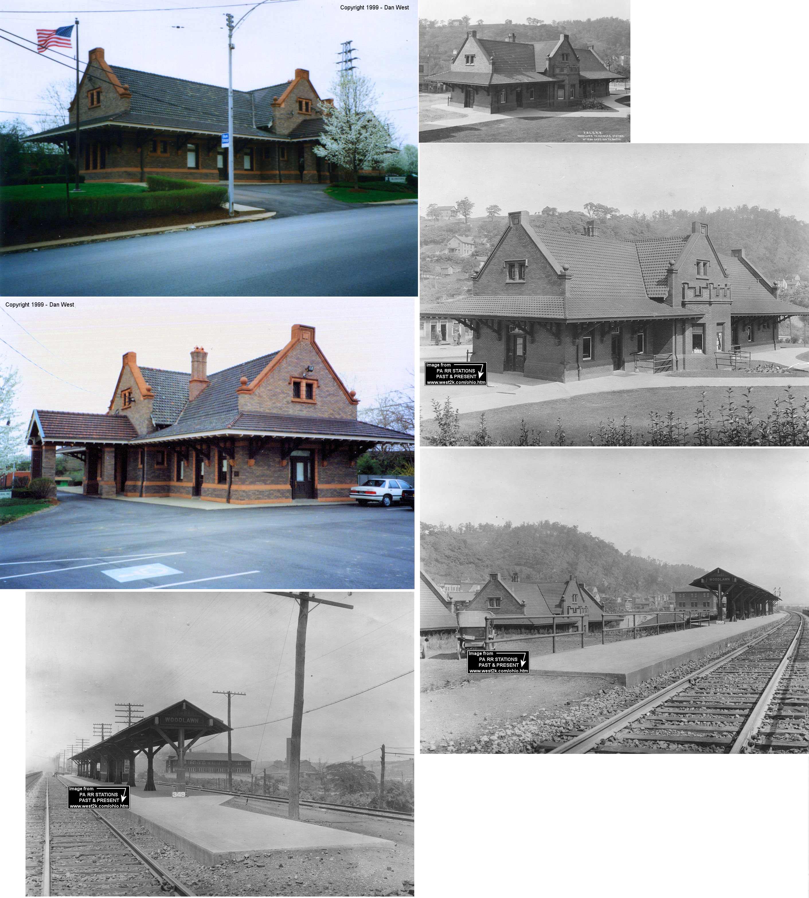
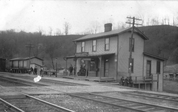
| Aliquippa (Woodlawn) |
 |
Station Street (GPS: 40.618801, -80.242845) |
P | Business | 1910 | In Use | Brick | |
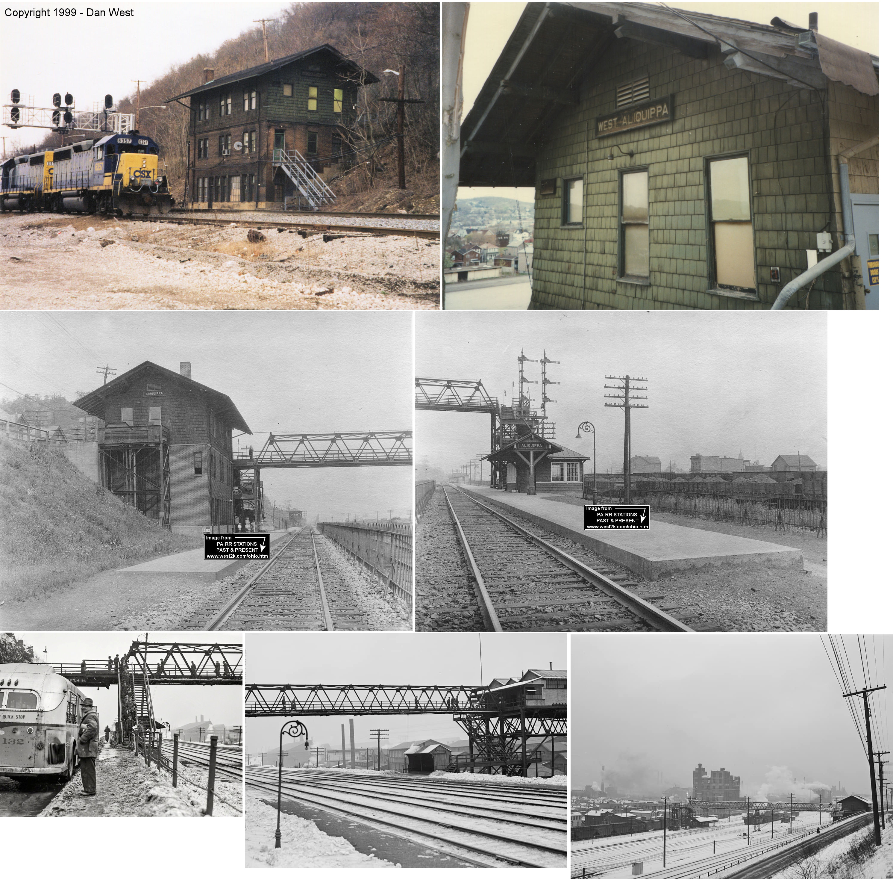
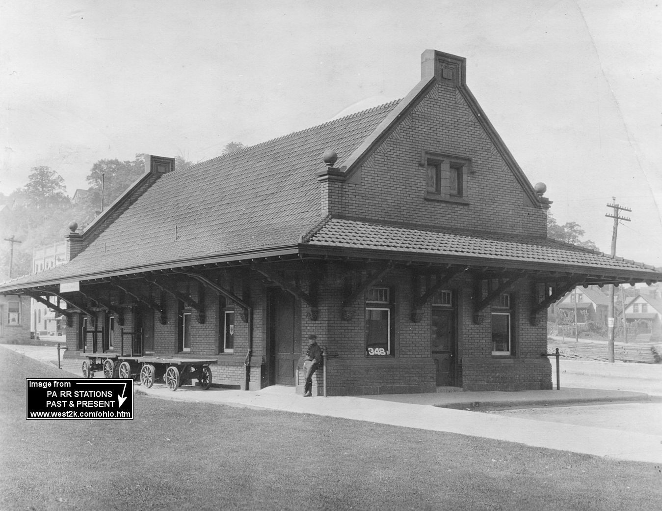
| Aliquippa (W. Aliquippa) |
|
Off PA-51/Hopewell Avenue (GPS: 40.636042, -80.244845) |
P | Railroad | 1912 | In Use | B/W |
|
| Beaver | |
East End Avenue and 3rd Street (PA68) (GPS: 40.697794, -80.296682) |
P | Civic | 1897 | In Use | Brick | |
| Beaver | |
East End Avenue and 2nd Street (GPS: 40.696788, -80.296139) |
F | Museum | 1910 | In Use | Brick | |
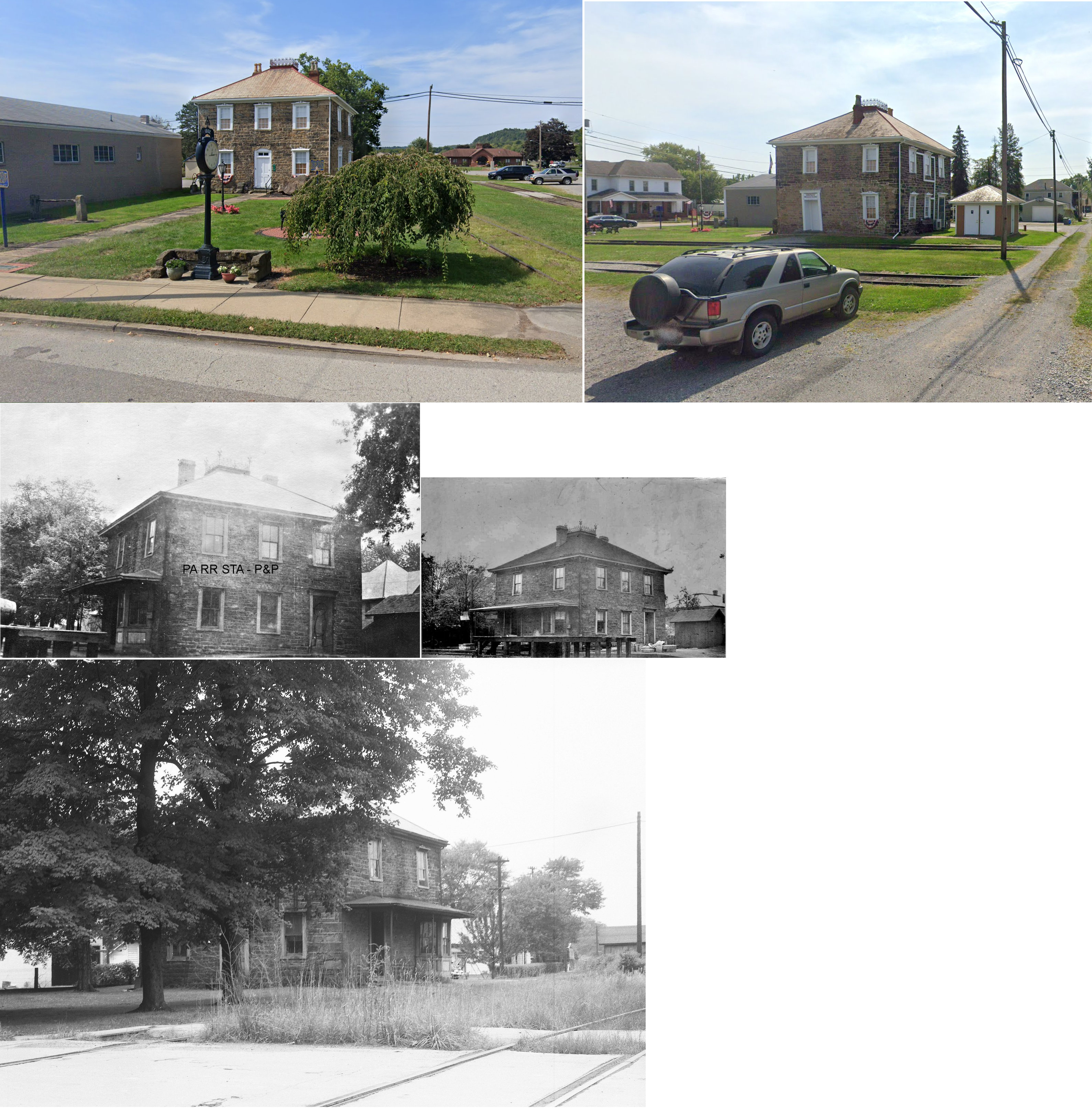
| Darlington |
 |
710 Market Street (GPS: 40.809998, -80.423642) |
C | Civic | 1806 | In Use | Stone |
|
| Fallston | |
Front Street
at west end of Fallston Bridge behind Col-Fin Steel plant. (GPS: 40.726857, -80.311329) |
C | Storage | 1911 | In Use | Brick | |
| Homewood |
 |
The north end of Main Street and St. Cloud Way (GPS: 40.814386, -80.328799) |
P | Vacant | 1852 | In Use | Wood |
|
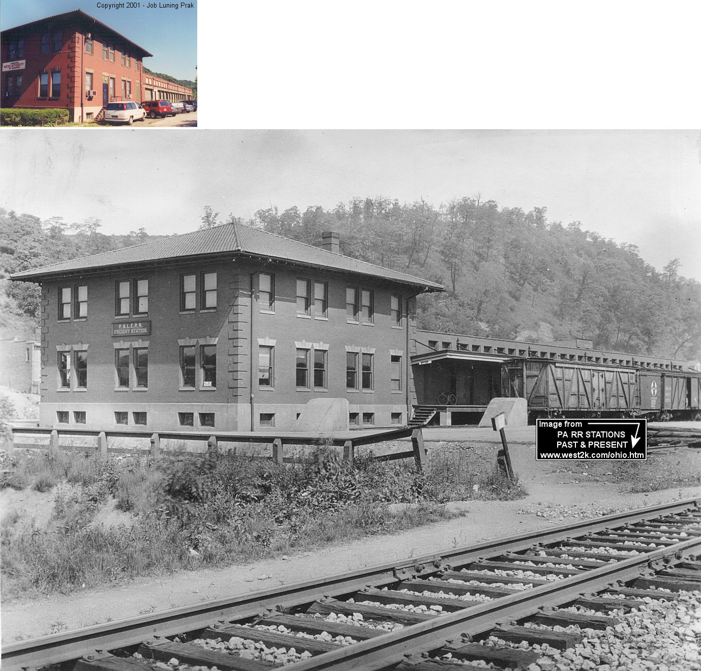
| Midland |
 |
Railroad Avenue between 5th and 6th Streets (GPS: 40.638759, -80.456807) |
F | Business | ???? | In Use | Brick | |
| Monaca (Colona) |
|
Pacific & 14th Avenue (GPS: 40.688502, -80.276181) |
P | Civic | ???? | ??? | Brick |
|
| Monaca (Colona) |
|
Pacific & 14th Avenue (GPS: 40.688693, -80.276454) |
F | Storage | ???? | ??? | Brick | |
| Monaca | |
West side of 6th Street between Pennsylvania Avenue and the tracks. (GPS: 40.690684, -80.284366) |
C | Club | ???? | ???? | Wood |
|
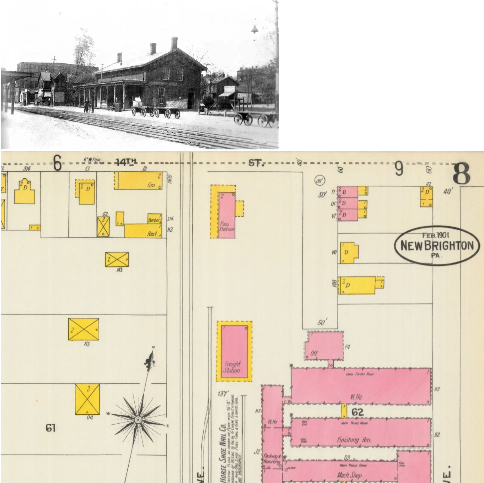
| New Brighton |
|
1100 5th Avenue (GPS: 40.732757, -80.310297) |
P | Museum | 1850 | Gone | Brick |
|
| STATIONS OF THE PAST | ||||||||
| Station Name |
Original Railroad |
Notes | ||||||
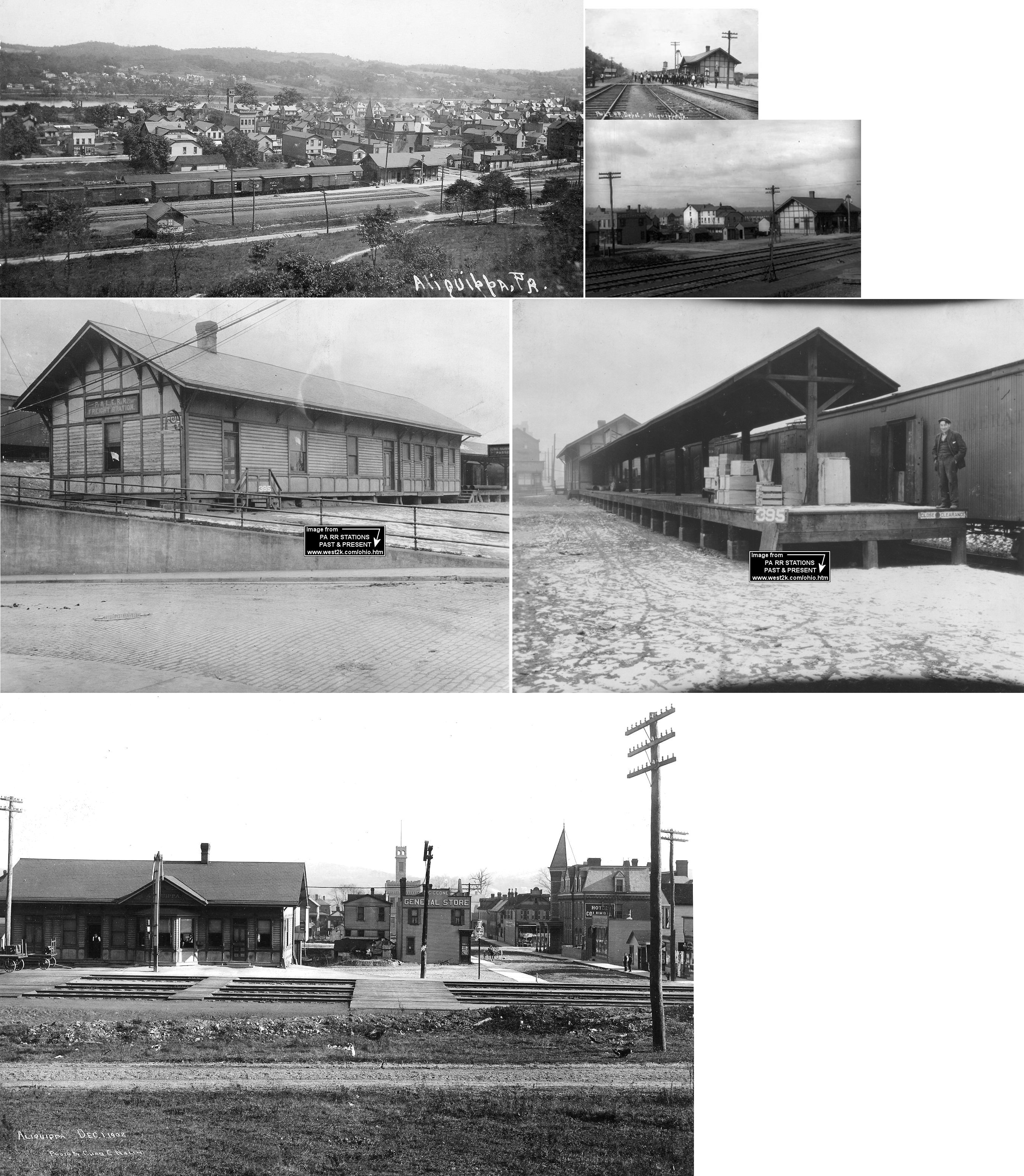
| Aliquippa (West Aliquippa) |
|
This was the original passenger station here and after 1912 it served as the freight station. It was on Erie Avenue just north of Third Street at GPS: 40.638211, -80.243979. There was also a tunnel under the tracks here that led across the tracks for access to the newer 1912 West Aliquippa passenger station. According to P&LE valuation records, it was built in 1892. | ||||||
|
Aliquippa (Woodlawn) |
|
Early station here. The original town of Aliquippa (what is now the area of West Aliquippa) merged with Woodlawn in 1928. West Aliquippa is actually the northern part of the town, but it is referred to as "west" because of its east-west (Pittsburgh to Youngstown) status on the P&LE. | ||||||
|
Aliquippa (Woodlawn) |
|
This express building that was on the south side of the passenger station was torn down. | ||||||
|
Aliquippa (Woodlawn) |
|
This freight station, built in 1910, was on Hopewell Avenue at GPS: 40.620272, -80.243019. After housing a business after it went out of service, it was torn down in the late 2010s/early 2020s. | ||||||
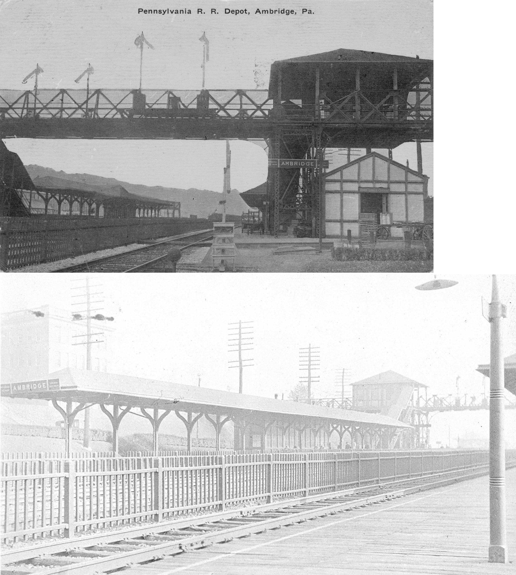
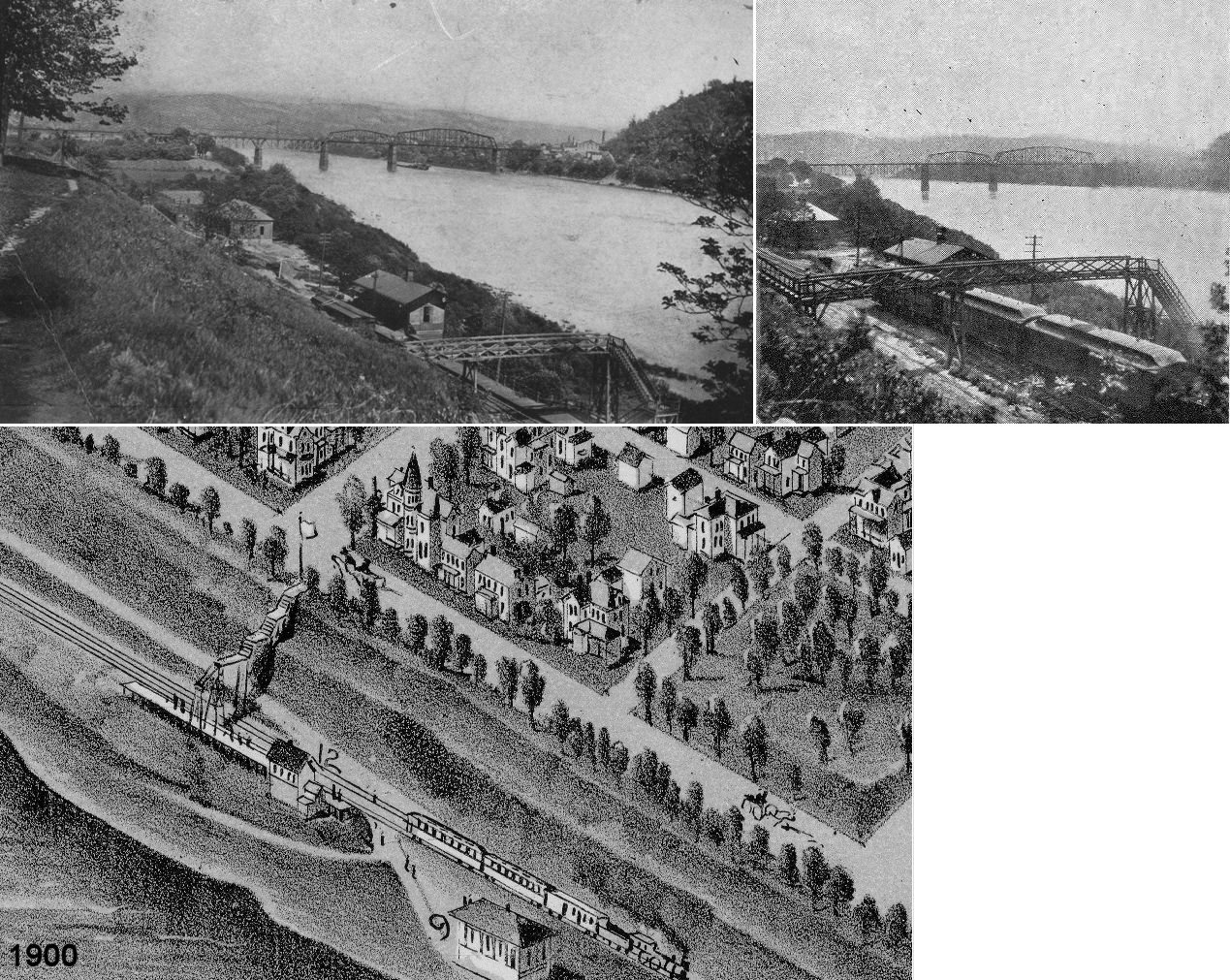
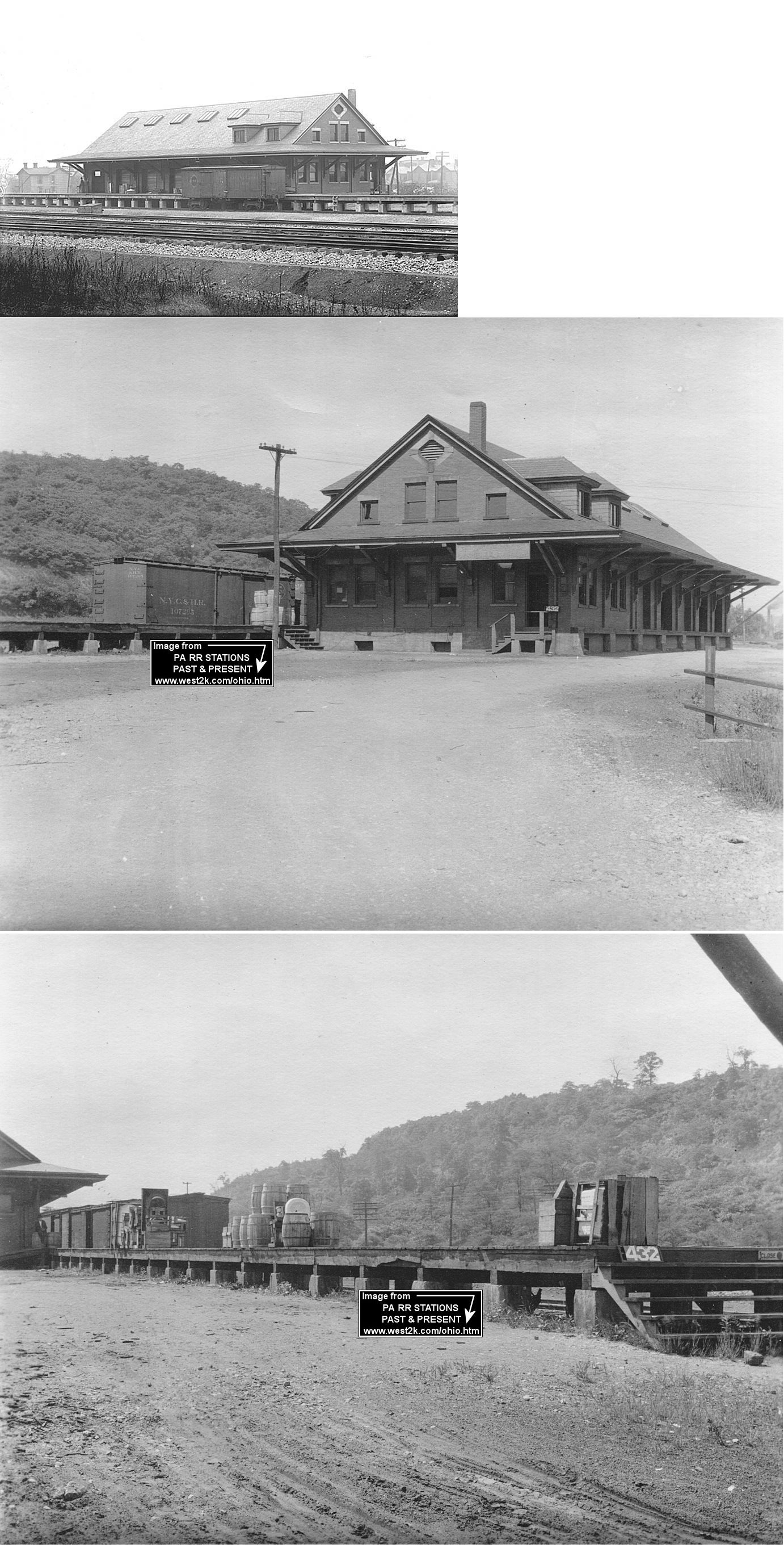
| Ambridge |
|
The ticket office here was elevated about 30 feet above the tracks on a footbridge that went from the main office across the tracks to the main bridge shop at the American Bridge Company. The ticket office was located at approximately GPS: 40.581626, -80.227458 with the platforms extending north from there. Passengers used stairs on either side of the tracks to reach the platforms from the bridge. There was also a newsstand on the bridge on the west side of the tracks and an express office below the ticket office on the east side. This is shown on the 1917 Sanborn map. | ||||||
| Ambridge |
|
There was a freight station southeast of the passenger station at approximately GPS: 40.580718, -80.226573. | ||||||
| Anderson Road |
|
See the listing below for Wireton. | ||||||
| Baden |
|
In 1876 the station was just south of where the tracks crossed Fours Run. A new station was built here in 1886 and another new station followed in 1892. | ||||||
| Baker Bank |
 |
This station is shown on the 1876 county map. It was near where current day Hoytdale is in the upper NE corner of Big Beaver Township. | ||||||
| Beaver | |
This station was across the river in Rochester. See the listing below for Rochester/Bridgewater/Beaver. | ||||||
| Beaver | |
The station was located at the base of a bluff between Insurance Street and College Avenue. The P&LE and Beaver Valley Traction Company offered faster service than the PRR from points west on the Ohio River so the station was likely torn down prior to WWII. | ||||||
| Beaver | |
The original freight house was near the south end of Fair Street at GPS: 40.699097, -80.297028. This station is shown on the 1906 Sanborn map. | ||||||
| Beaver | |
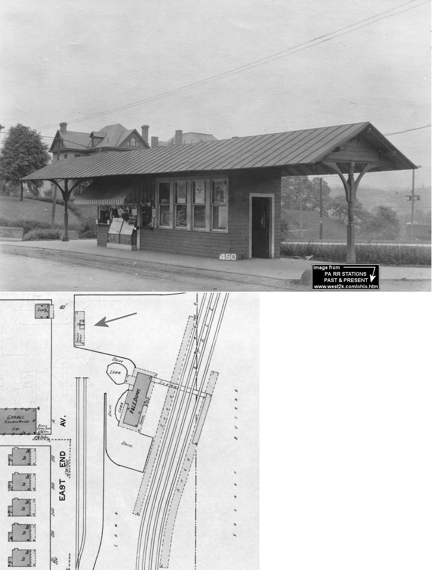
This trolley stop/newsstand was built and owned by the P&LE and sat on the station grounds on the east corner of East End Avenue and 3rd Street at GPS: 40.698144, -80.297387. This was the terminus of the Ohio River Passenger Railway (the section was known as "The Scenic Route"). This line ran from Steubenville, OH to Beaver where it connected here with the P&LE. Here is an article from the Ellwood City Ledger about the Scenic Route. | ||||||
| Beaver
Falls (Eleventh Street) |
|
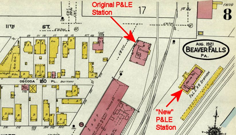
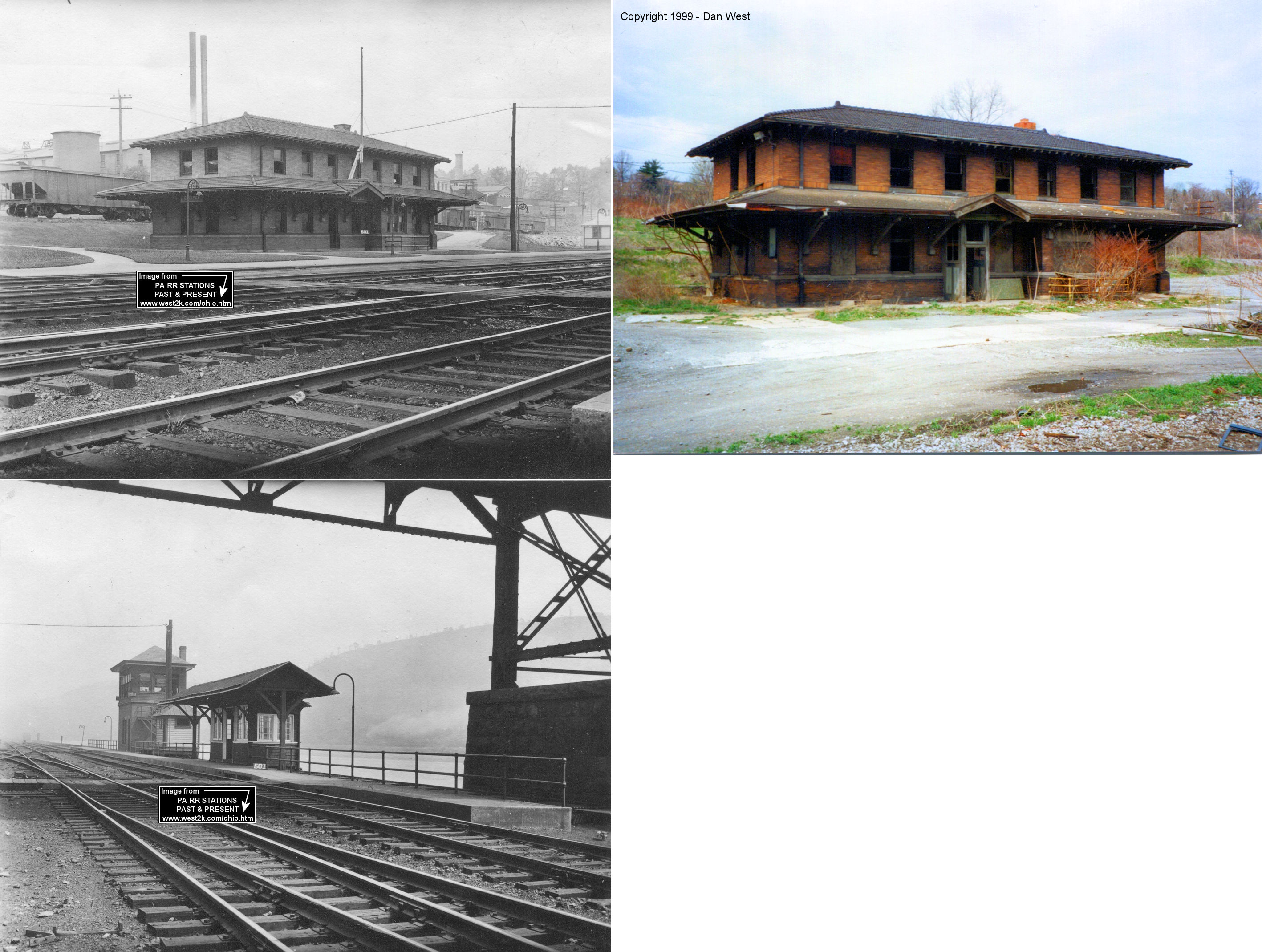
The first P&LE passenger station here was on the SE corner of 1st Street and 11th Avenue (GPS: 40.751746, -80.312042). It was listed on P&LE timetables as "Eleventh Street." After a new station was built, this building remained used as a RR office. | ||||||
| Beaver
Falls (Eleventh Street) |
|
A new station was built at 11th Street across the tracks (these tracks are now gone) from the old station on the new mainline in 1900. For quite some time the old station and new stations both stood here with the old station being relegated to being used as a RR office. The new station was located at GPS: 40.751443, -80.311566. | ||||||
| Beaver Falls (Eleventh Street) |
|
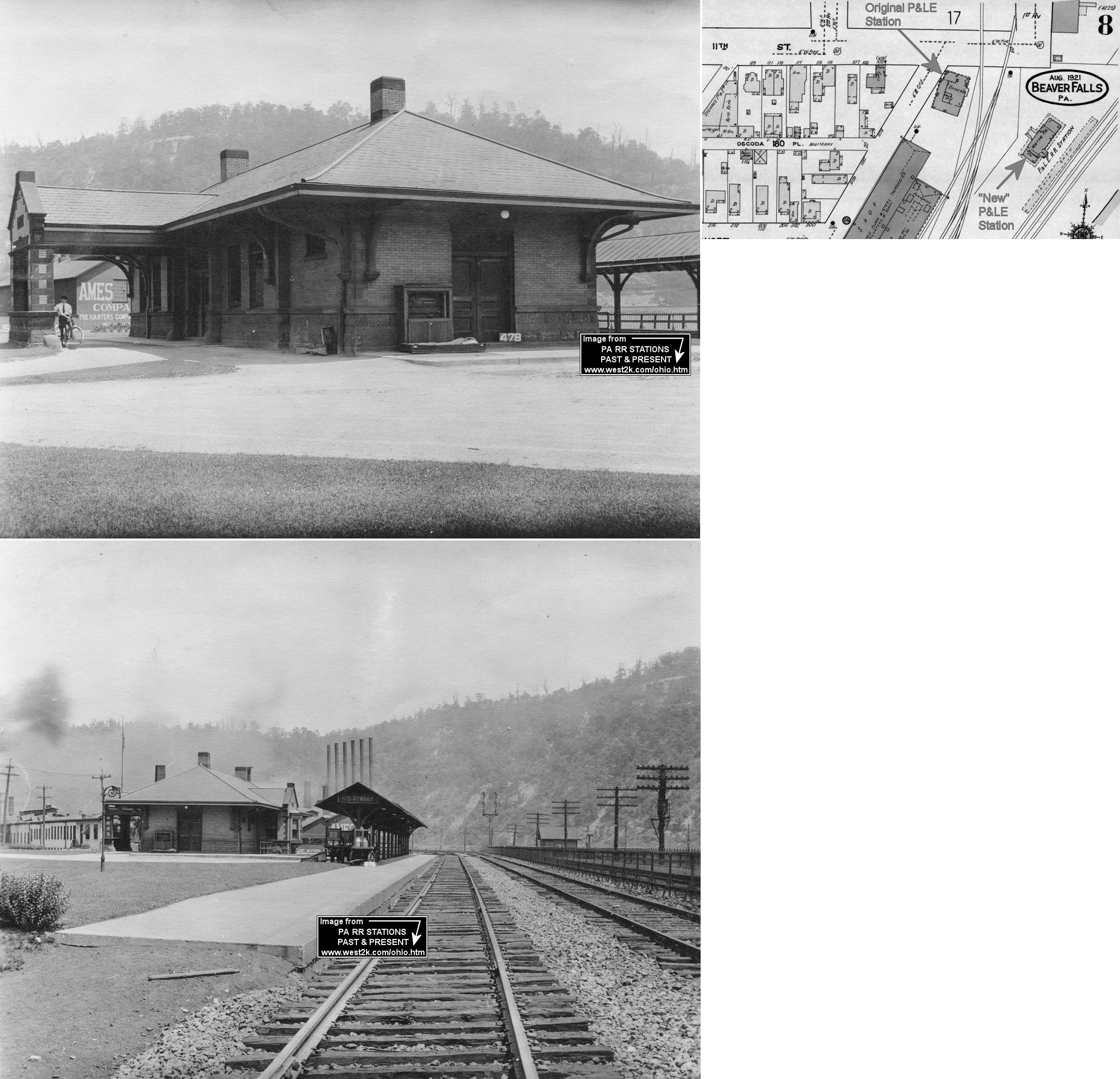
This brick freight station sat at the corner of 11th Street and 1st Avenue (GPS: 40.752139, -80.312369). It was built 1905 according to P&LE valuation records. It was demolished in early 2007. There was a smaller, frame freight station at this same location prior to the construction of the new brick station. | ||||||
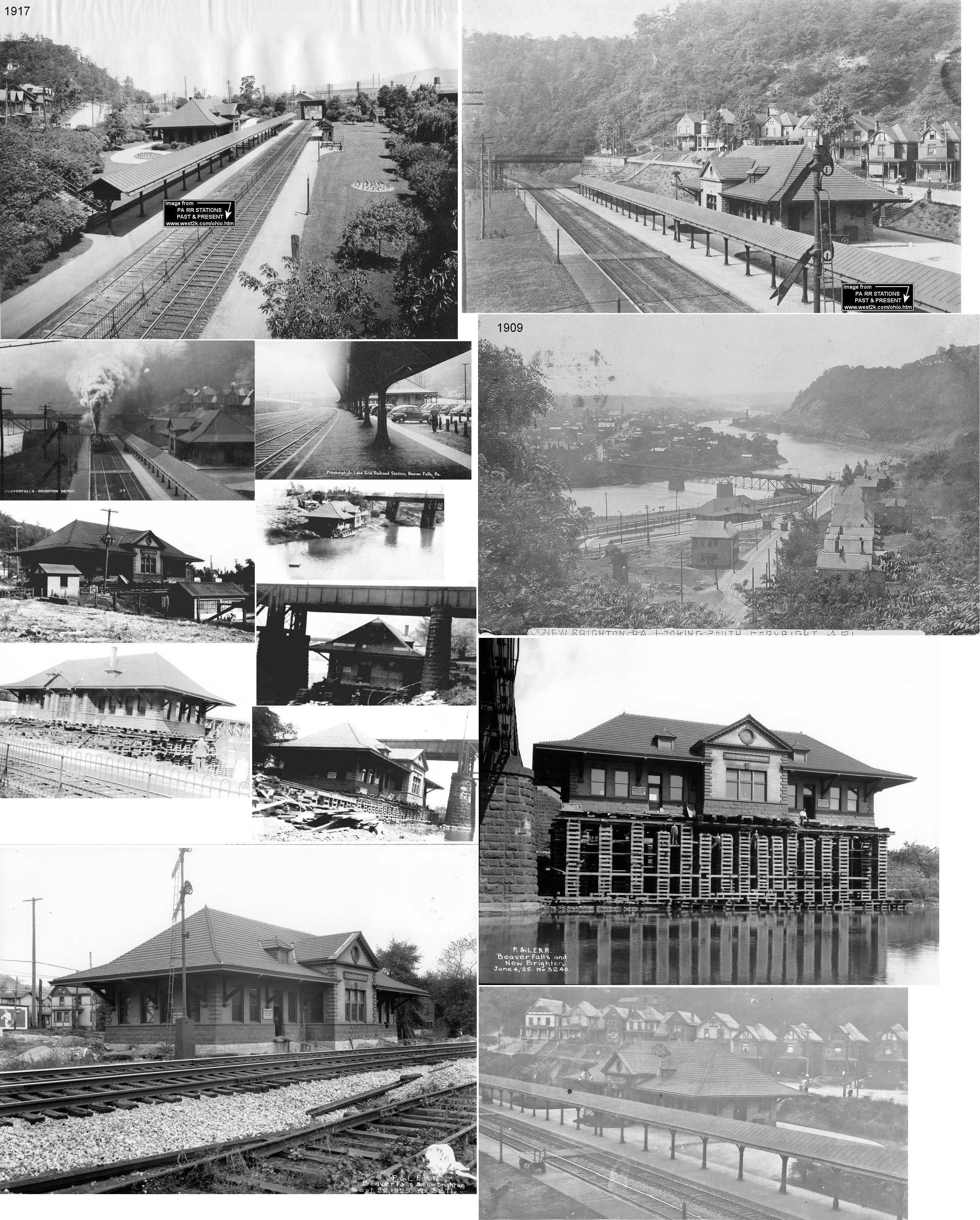
| Beaver Falls (New Brighton) |
|
The original wood frame station here was likely at the same location as the station listed below. | ||||||
| Beaver
Falls (New Brighton) |
|
Listed on P&LE timetables, and on the station's signboard, as "Beaver Falls & New Brighton," this brick station was built in 1905 and then was moved in the spring of 1925 about 300 yards south of its original location. It was moved to make room for a new PRR crossing at that location. It was moved across the P&LE tracks, down to the river bank, under the PRR bridge, and back across the P&LE tracks to its new location. Photos show station in original location on cribbage for the move and after being moved under the PRR bridge. I believe the original location was GPS: 40.742248, -80.320382 and the new location was GPS: 40.740893, -80.320947. It was demolished in the 1970s. | ||||||
|
College
Hill (Beaver Falls) |
|
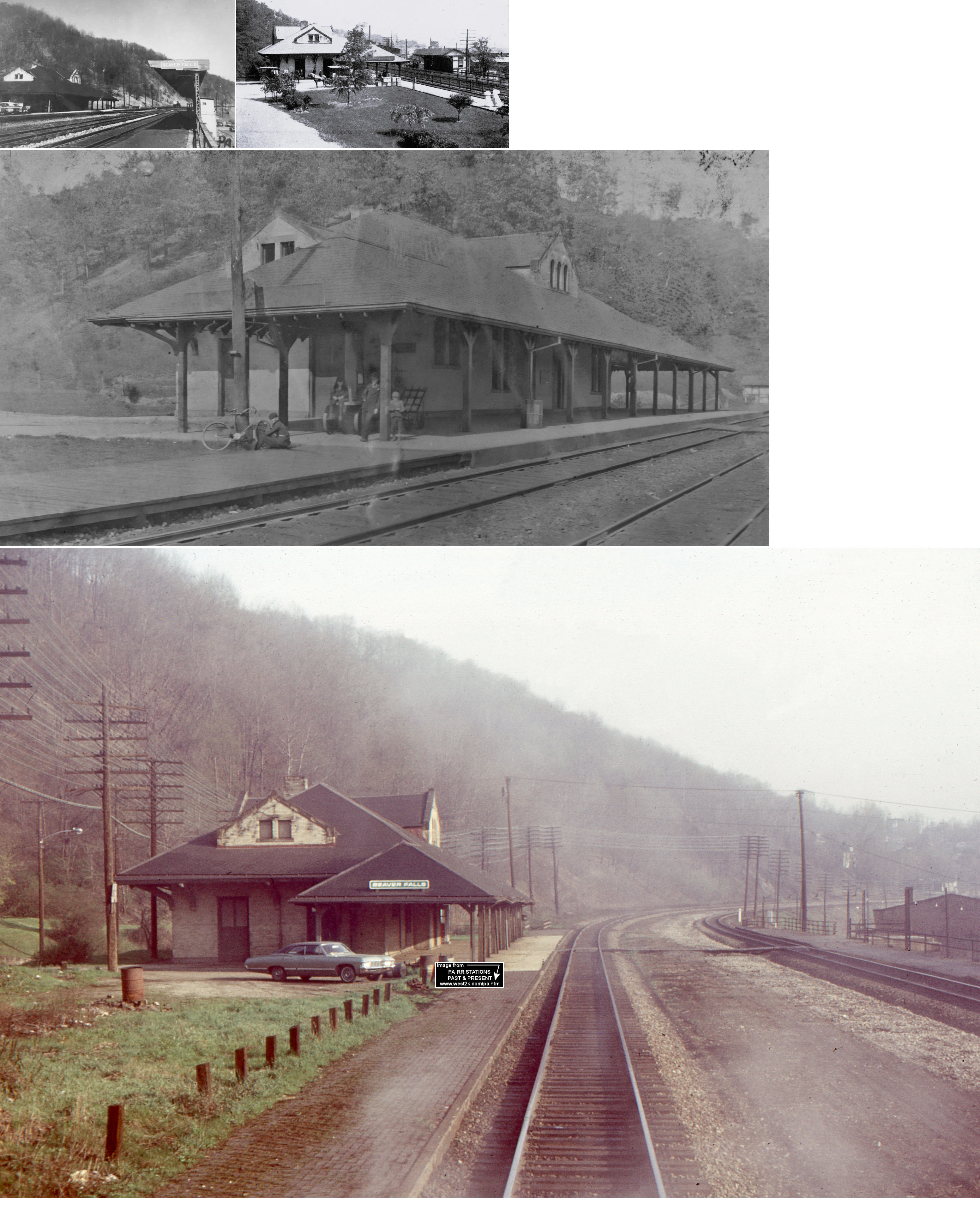
This station was built in 1909-1910 and was at PA18 & PA588 (GPS: 40.767398, -80.318886). It sat vacant for many years and burned down on 6/19/2017. | ||||||
| Beaver Falls |
|
The original brick passenger station was near the corner of 9th Avenue and 5th Street at GPS: 40.746741, -80.322734. It is shown on the 1886 Sanborn map. There was an engine house across the tracks. On the 1896 map the new station appears and this station is marked as a freight house. | ||||||
| Beaver Falls |
|
The second brick passenger station, built in 1893, was at the east end of Lower 11th Street at GPS: 40.751507, -80.325277. | ||||||
| Beaver Falls |
|
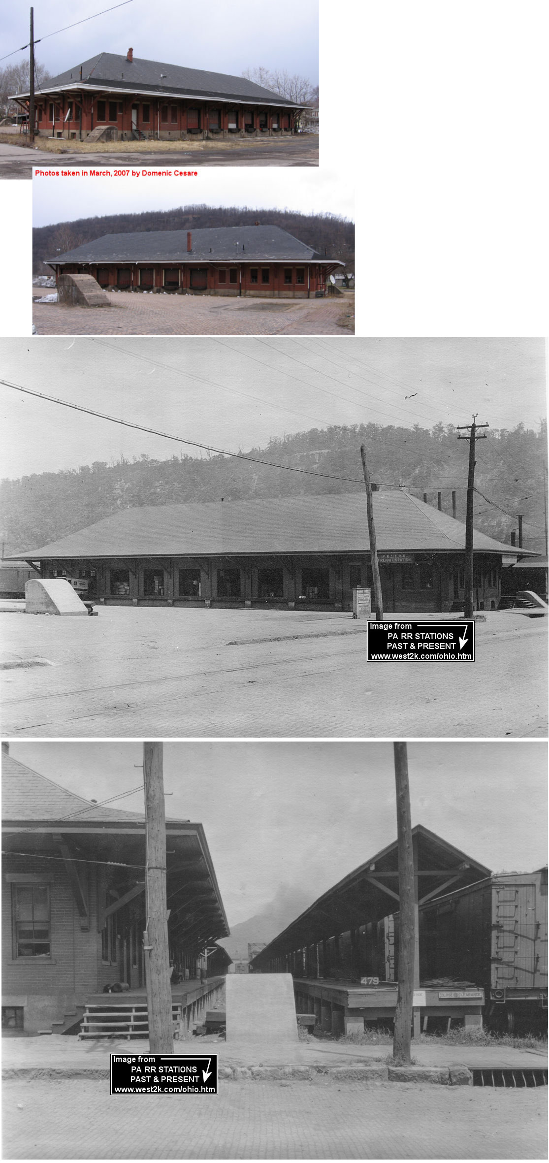
A new, larger brick freight station was built in 1909-1910. It was located on 11th Avenue between 11th Street and 12th Street (GPS: 40.752482, -80.324892). | ||||||
| Cannelton |
|
The New York, Pittsburgh & Chicago (NYP&C) was the predecessor to the Pittsburgh, Lisbon & Western (absorbed by the Youngstown & Southern in 1945). Despite its name the railroad only went from Pittsburgh to Youngstown, OH. The depot was on the east side of Ridge Road on the north side of the tracks at GPS: 40.799114, -80.475876. | ||||||
| Clinton |
|
Clinton was the next station north of Homewood on the New Castle and Beaver Valley Railroad. This station is shown on the 1876 map. | ||||||
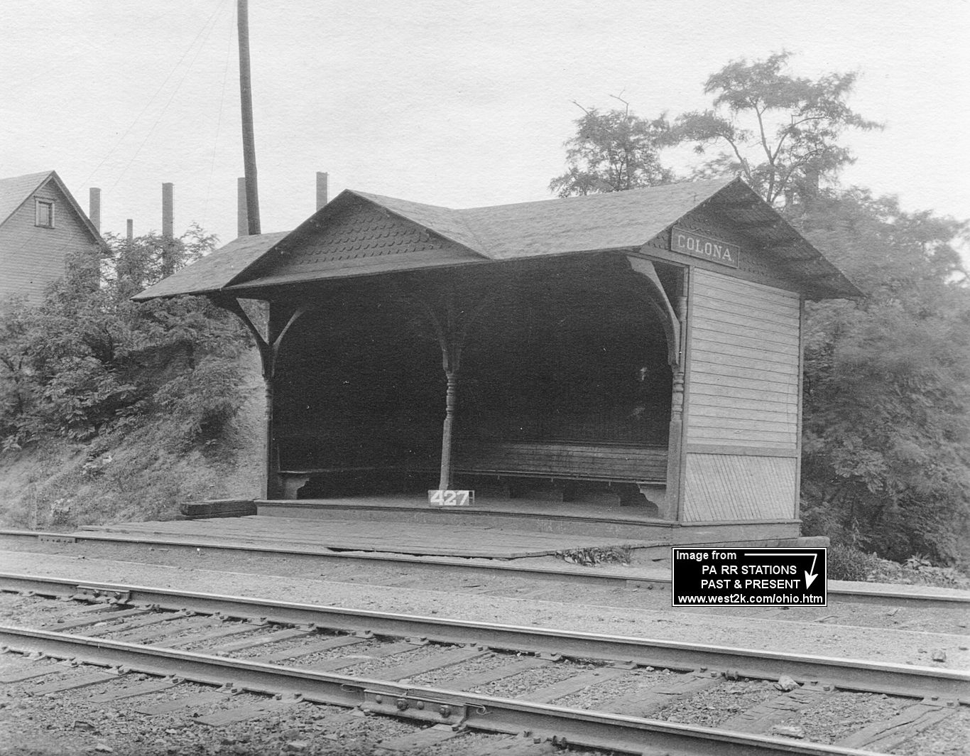
| Colona (South Monaca) |
|
There was likely a wooden station here that predated the brick station that still exists and was moved north to Monaca. | ||||||
| Colona (South Monaca) |
|
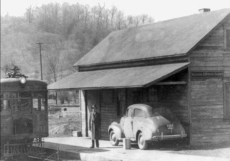
When the brick station was moved from here to Monaca, the railroad replaced it with this passenger shelter in 1910. Like many of the shelters on the line, it was built by the Anderson-Cook Company. | ||||||
| Conway |
|
A class B station was built here in 1902. | ||||||
| Cook's Station |
|
In 1876 this was the next station to the SW of Industry. This is probably part of Midland today. | ||||||
| Dry Run |
|
See listing for Glasgow below. | ||||||
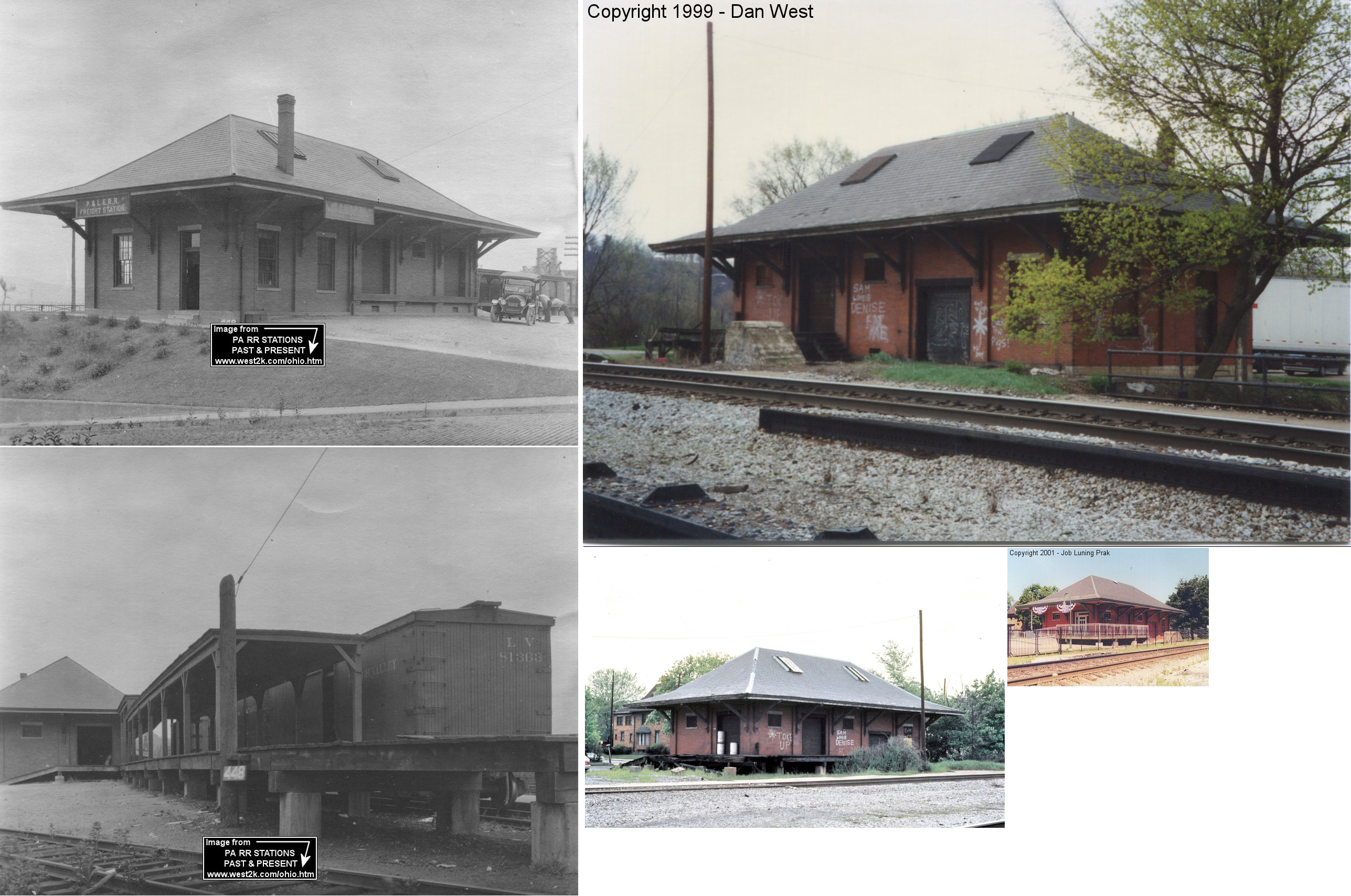
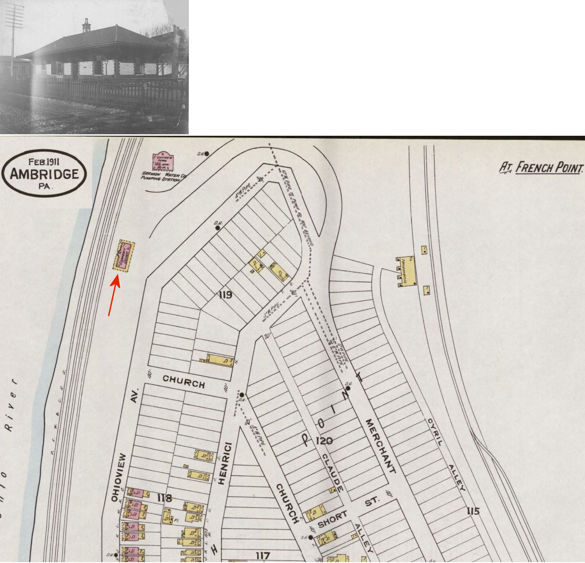
| Economy (OLD Economy) |
|
This station was just north of the end of 12th Street (GPS: 40.594769,-80.234062). | ||||||
| Economy |
|
A later station was at the end of Merchant Street at GPS: 40.601598, -80.233783. | ||||||
| Economy |
|
There was a freight station on the south side of 11th Street between Melrose Street and Duss Street (GPS: 40.593290, -80.228096). | ||||||
| Fallston |
|
The original pre-1911 wood frame station here was essentially in the same location as the existing brick station. | ||||||
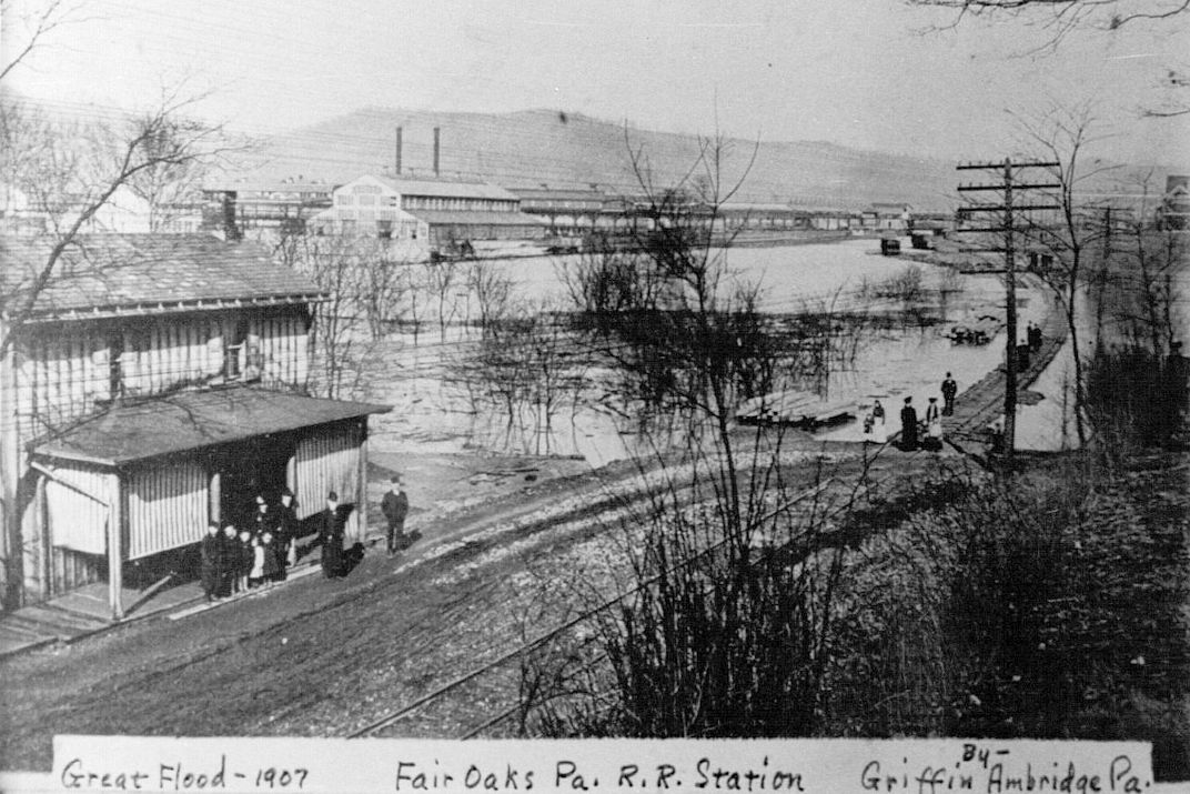
| Fair Oaks |
|
By 1945 there was only a freight station listed for this location. Not sure if that was the old passenger station or a different building. | ||||||
| Fetterman |
 |
A station is listed here on the 1923 PRR List of Stations & Sidings. | ||||||
| Fombell |
 |
|||||||
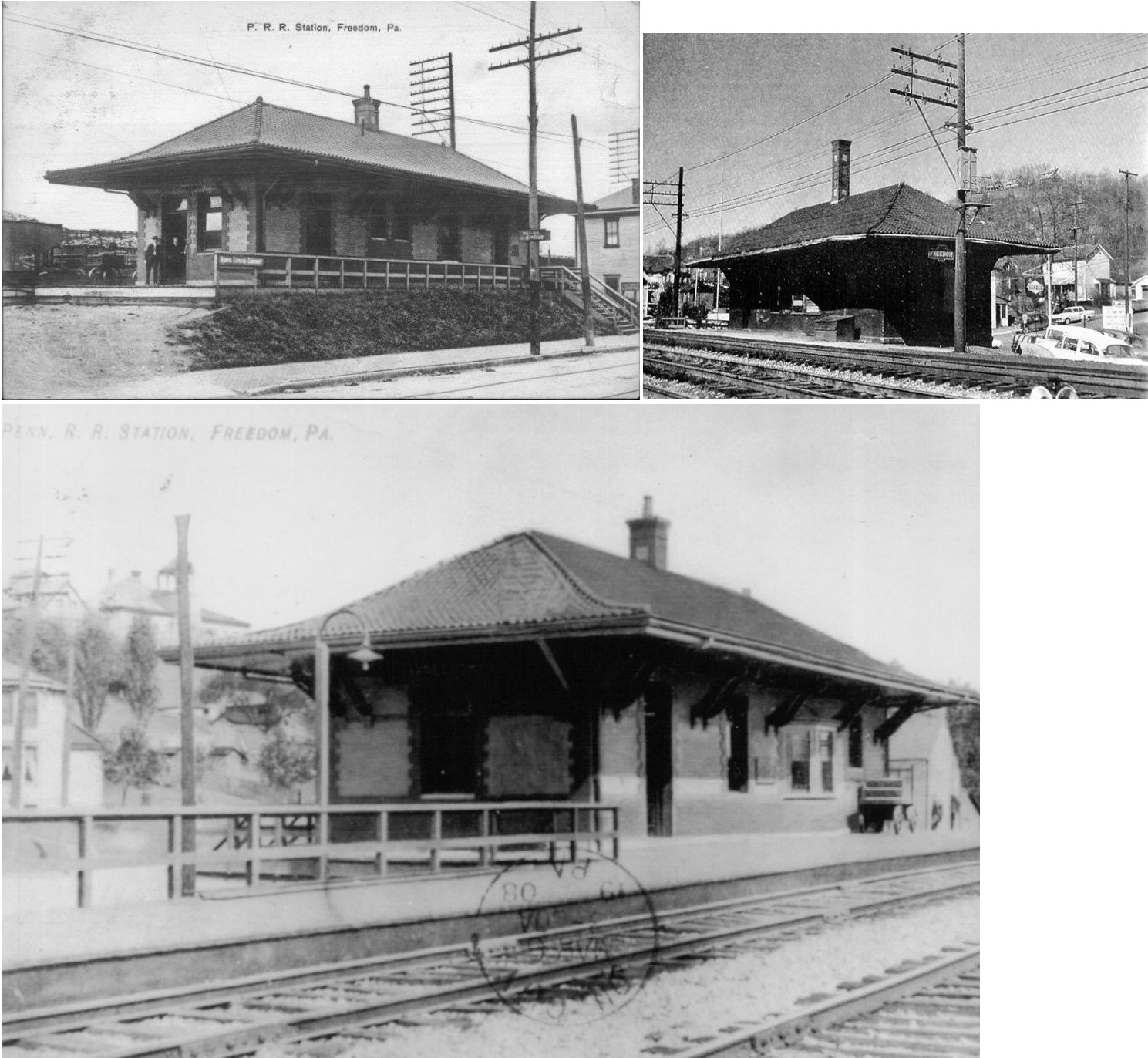
| Freedom |
|
In 1876 there was a passenger station on the NW side of Betz Street on the SW side of the tracks. Later there was a separate freight station here as well. | ||||||
| Freedom |
|
In 1903 the station was near the foot of 5th Street on the SW side of the tracks (GPS: 40.688418, -80.258047). There was a small freight house on the NE side of the tracks (GPS: 40.688562, -80.257870). That freight station was gone by 1908. | ||||||
| Freedom |
|
The 1925 Sanborn map (of Rochester) shows a freight station along 3rd Avenue between 13th and 14th at approximately GPS: 40.680519, -80.250264. This station was built in 1905 (The Pittsburgh Post, 8-22-1905). | ||||||
| Glasgow (Dry Run) |
|
According to PRR valuation records from 1917, there was no station here at that time. Not sure if one existed before that. | ||||||
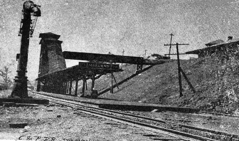
| Highland |
|
A station is shown here on the 1923 PRR List of Stations & Sidings. | ||||||
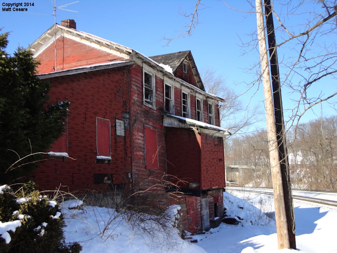
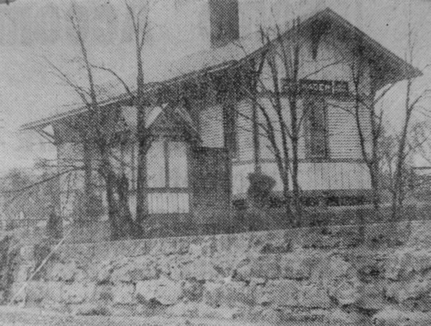
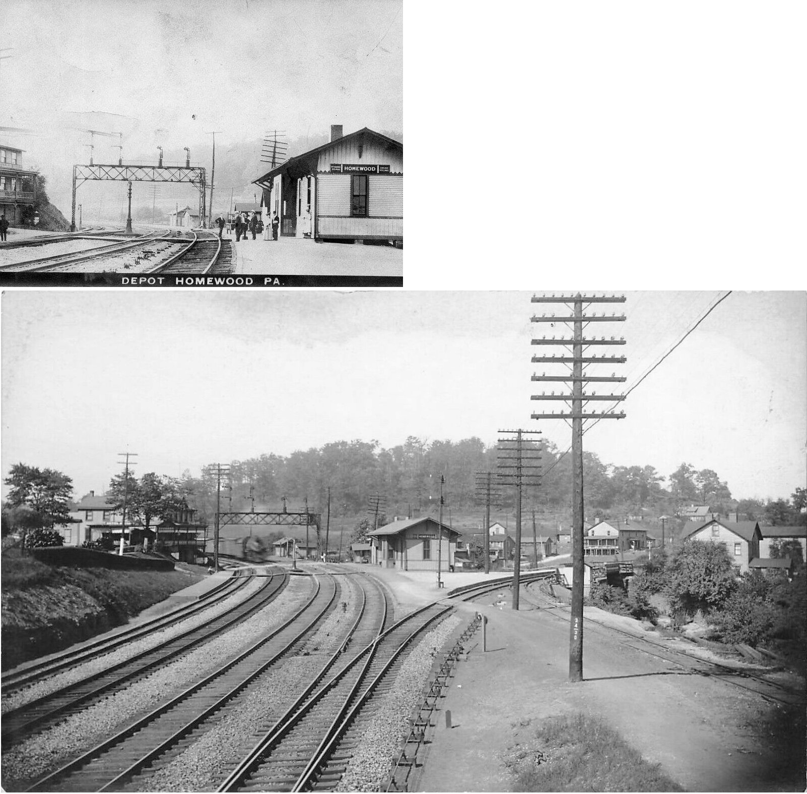
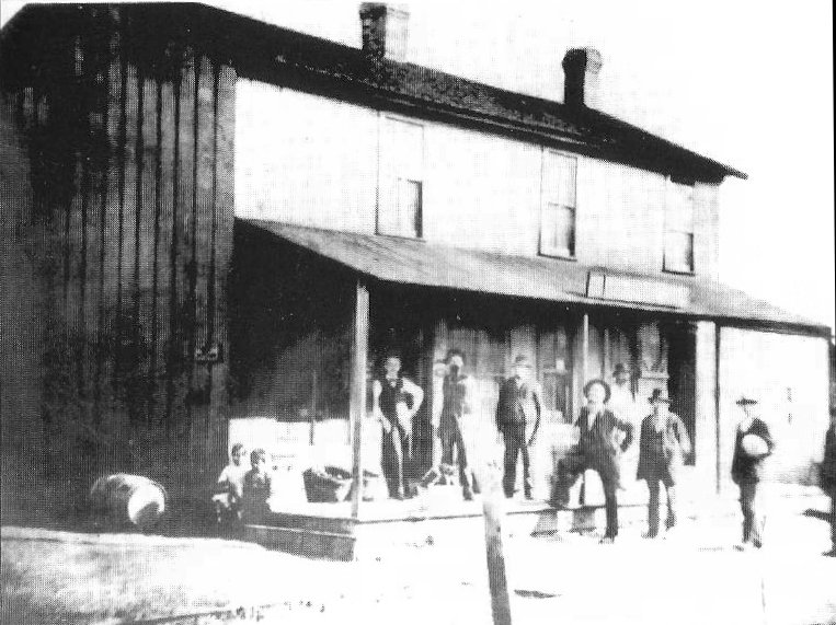
| Homewood (Homewood Jct.) |
|
The original station here was built in 1864. | ||||||
| Homewood (Homewood Jct.) |
|
This station was on the NE side of the tracks opposite the corner of Cloud Way and Main Street at GPS: 40.814375, -80.328407. It was built in 1886. | ||||||
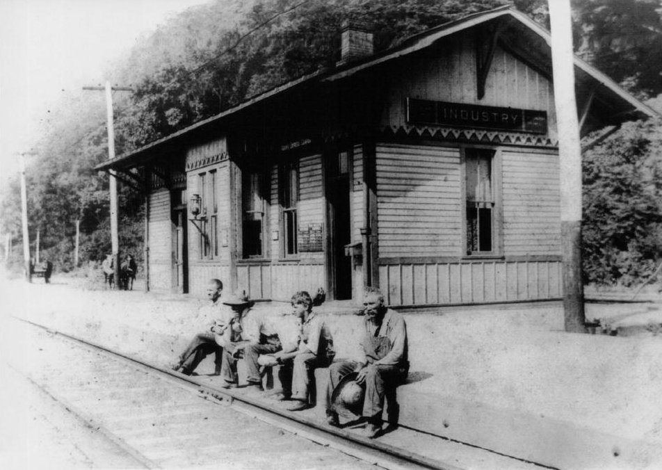
| Industry |
|
"YN" tower was .3 mile from the station. | ||||||
| Kenwood |
|
See listing below for New Brighton (Kenwood). | ||||||
| Kiasola |
|
This was an early station on the line. It is not listed on later timetables. It was near where the tracks cross Moon Run (GPS: 40.673393, -80.259070). | ||||||
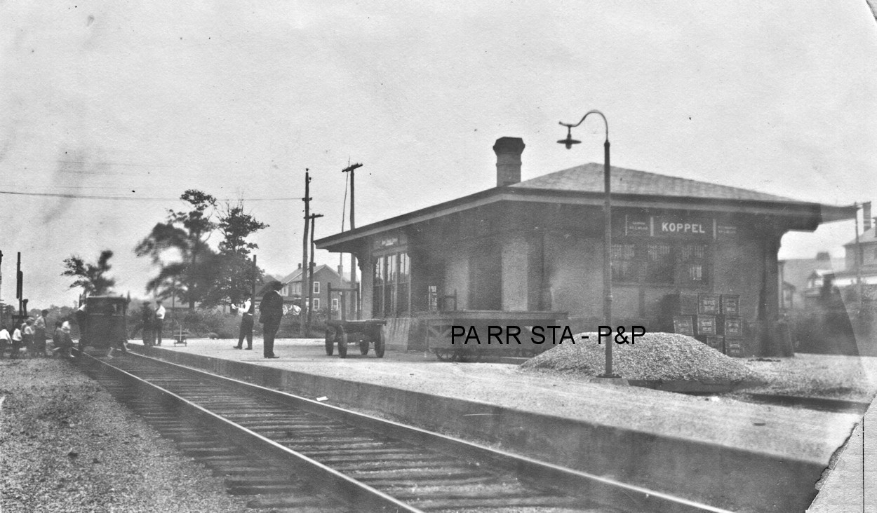
| Koppel |
|
This station was built in 1913 and was on the north side of Arthur Street on the west side of the tracks at GPS: 40.834585, -80.324338. Photo shows school children boarding some sort of track speeder/doodlebug. | ||||||
| Legionville |
|
|||||||
| Logans |
|
|||||||
| Merrill Station (Oakwood) |
|
This station is shown as Oakwood on the 1876 map. A station is listed here on the 1923 PRR List of Stations & Sidings. | ||||||
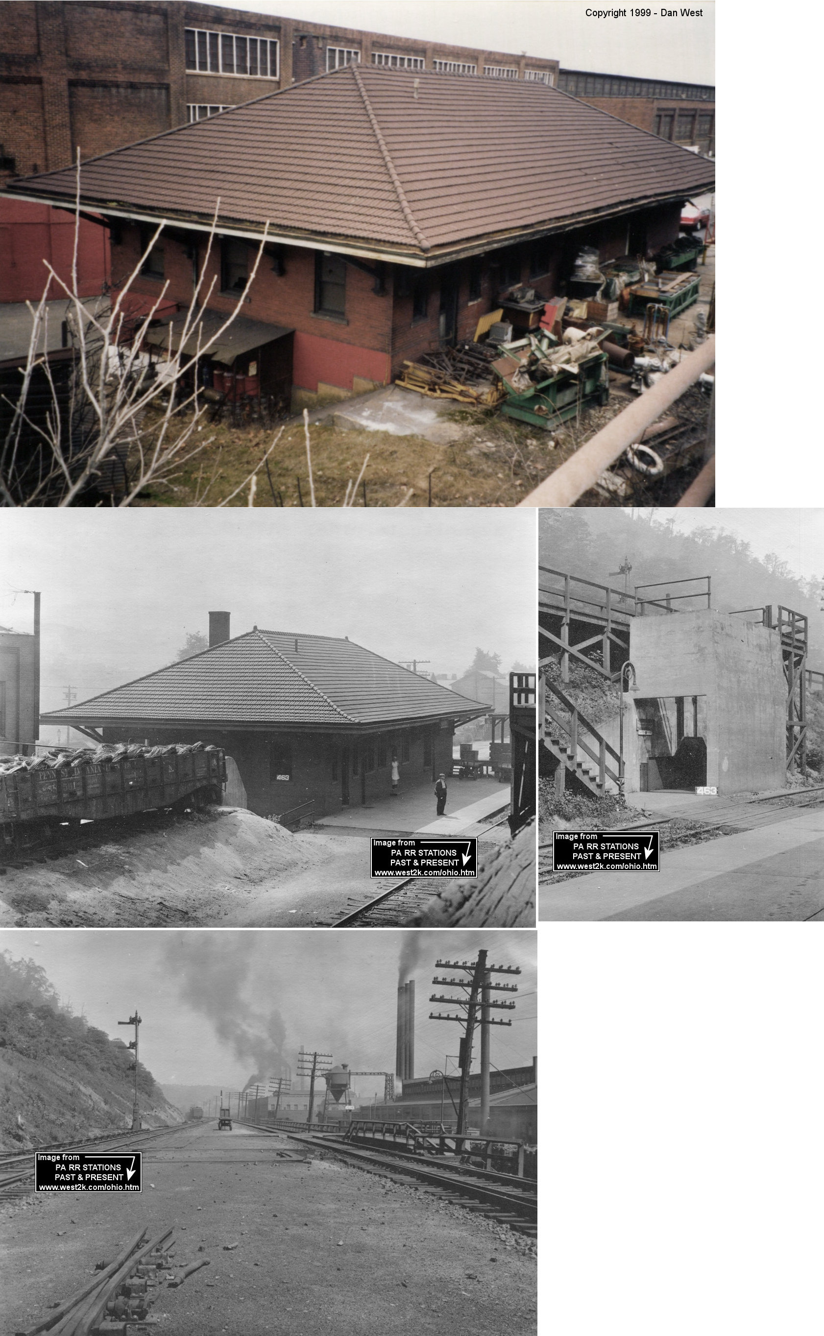
| Midland |
|
The station that is still standing at Midland is indicated as the freight station on the 1917 Sanborn map. The passenger station was at MP 13.8 (distance from Conway), while the freight station was at MP 17.1 on the "Hill Track" (as indicated on the 1923 PRR List of Stations & Sidings). It was 3.3 miles from the freight station between the east end of the storage yard and Midland Barge. It was 2.2 miles from the Industry station. Can anyone give a description of this location or GPS coordinates? The passenger station is not shown on any of the Sanborn maps. | ||||||
| Monaca |
|
This freight station was on the south side of Pennsylvania Avenue at approximately GPS: 40.686285, -80.270854. It was built in 1911 and torn down in the early 1990s. | ||||||
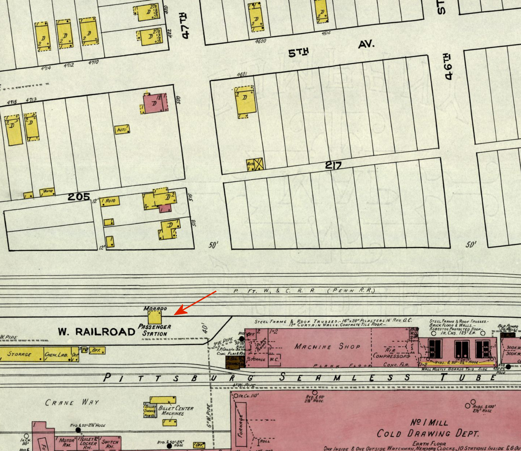
| Morado |
|
This small station, likely a passenger shelter only, was on what used be West Railroad Street alongside the former site of the Pittsburgh Seamless Tube Company. The station was at GPS: 40.785911, -80.333791. This station was also known as Wallace Run at some point in its history. | ||||||
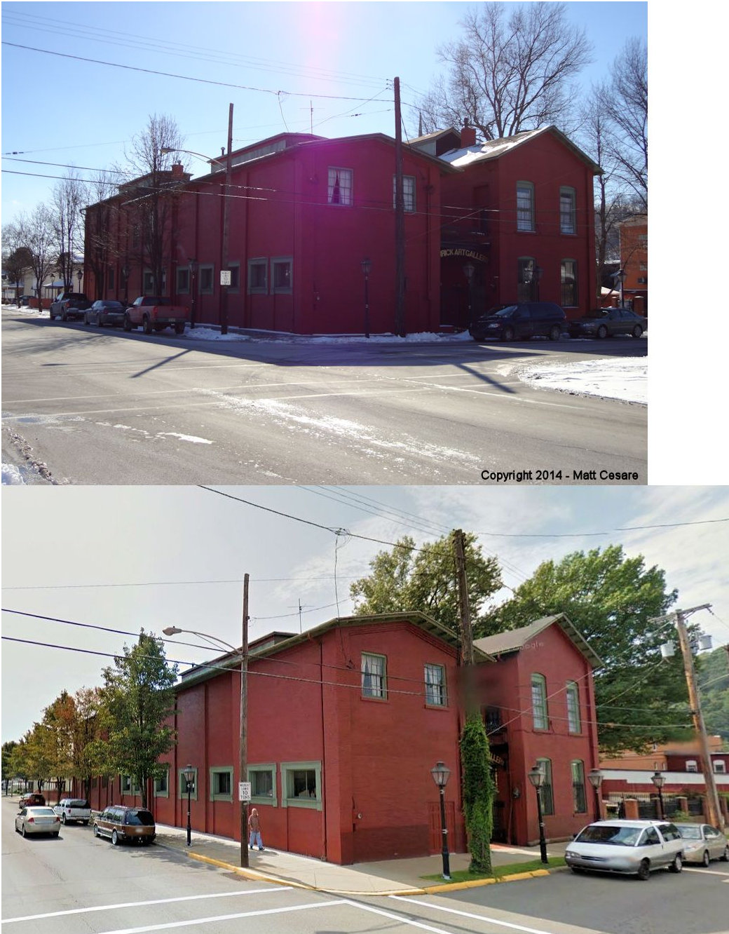
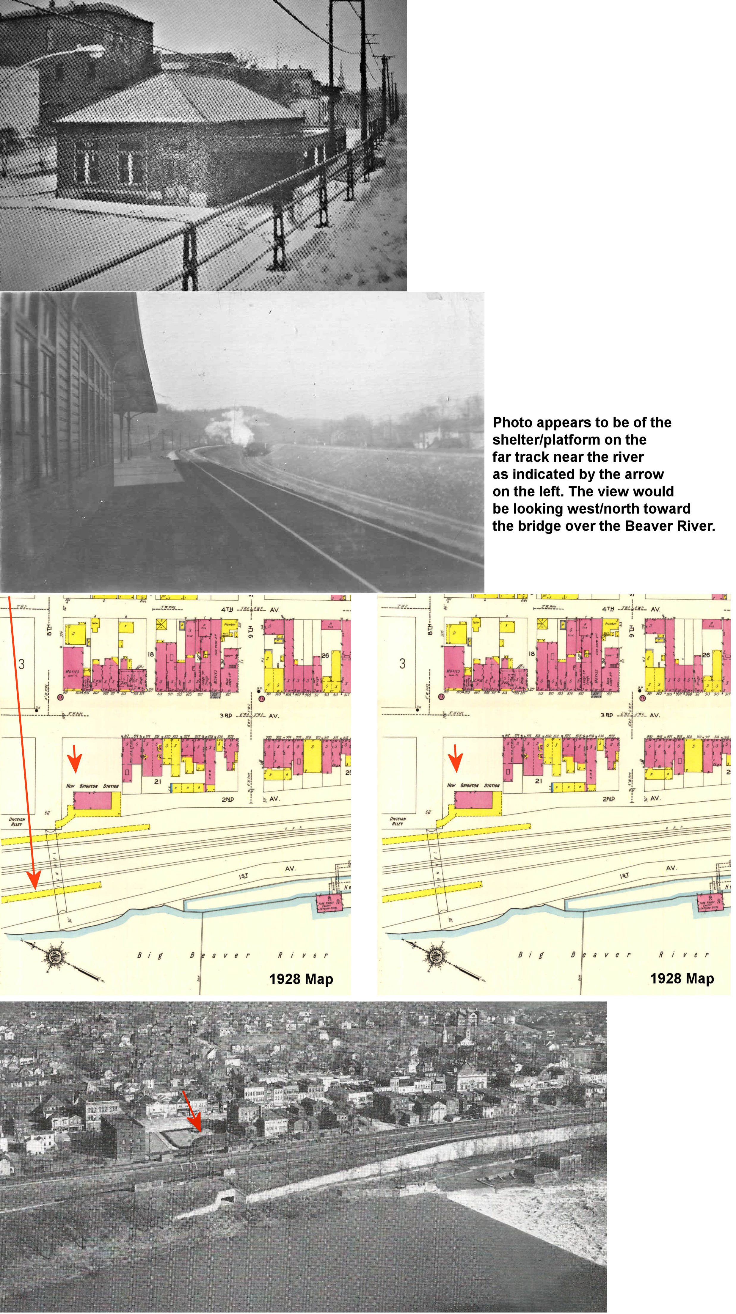
| New Brighton |
|
The first station is still standing at 1100 5th Avenue (listed in the Existing Stations table above). The second station here, which was a two-story brick building, was on the east corner of 5th Avenue and 14th Street (formerly Pearl Street) (GPS: 40.729883, -80.307429) before the main line was moved down by the river. There was also a one-story brick freight house just to the SE along 5th Avenue at GPS: 40.729349, -80.307019. When the tracks along 5th were abandoned, a spur for access to the freight station remained. | ||||||
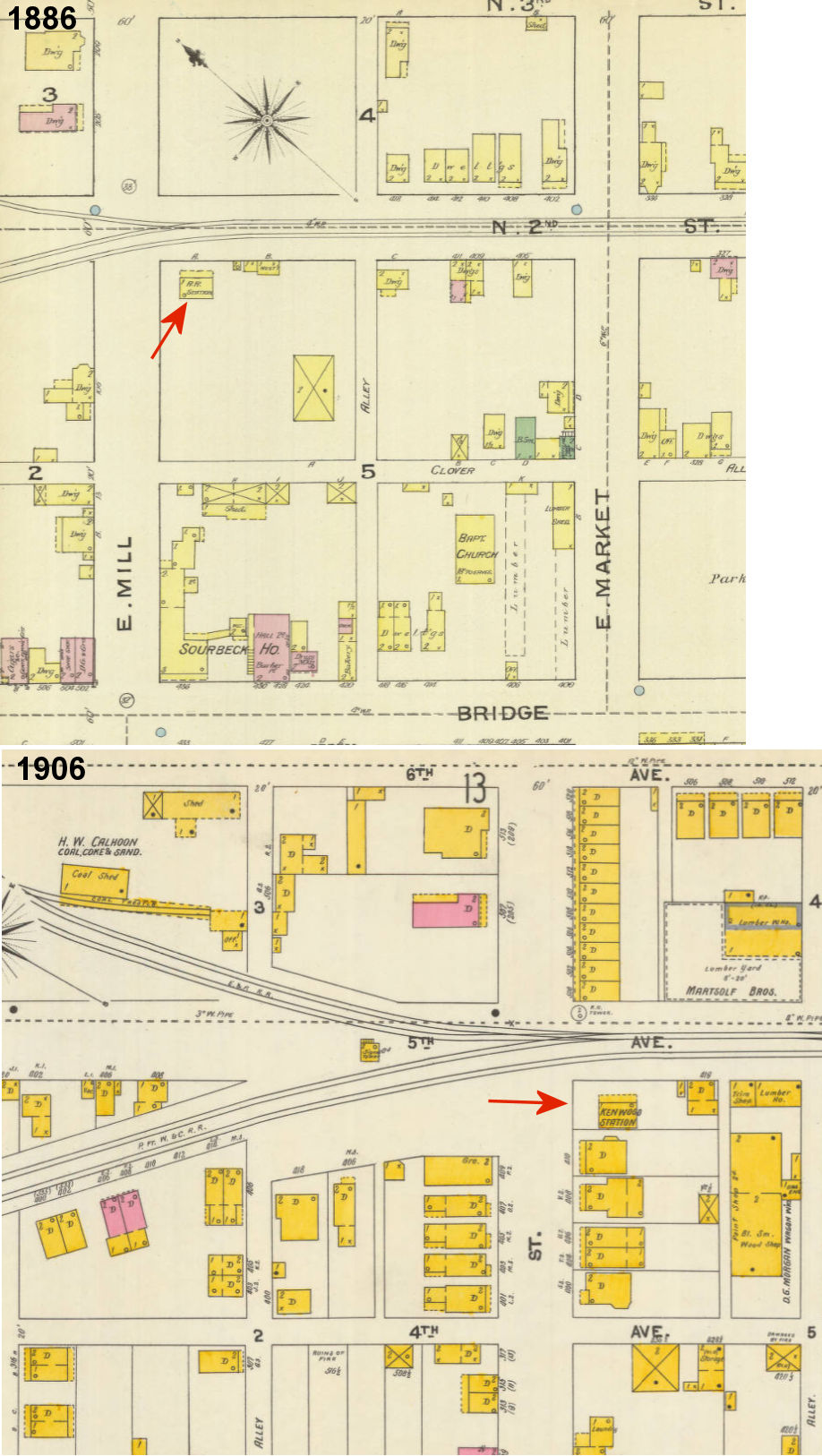
|
New Brighton (Kenwood) |
AND |
This small station is shown on the 1886-1928 Sanborn maps at the SW corner of 5th Street (formerly Mill Street) and 5th Avenue (formerly North 2nd Street) at GPS: 40.738659, -80.315931. On the 1928 map the station is still standing, but marked as "not used." It likely served the PY&A (E&P) after that line connected here. | ||||||
| New Brighton |
|
After the main line was moved down by the river in 1926, the third New Brighton Station was built at the corner of 2nd Avenue and 8th Street at GPS: 40.734755, -80.314790. | ||||||
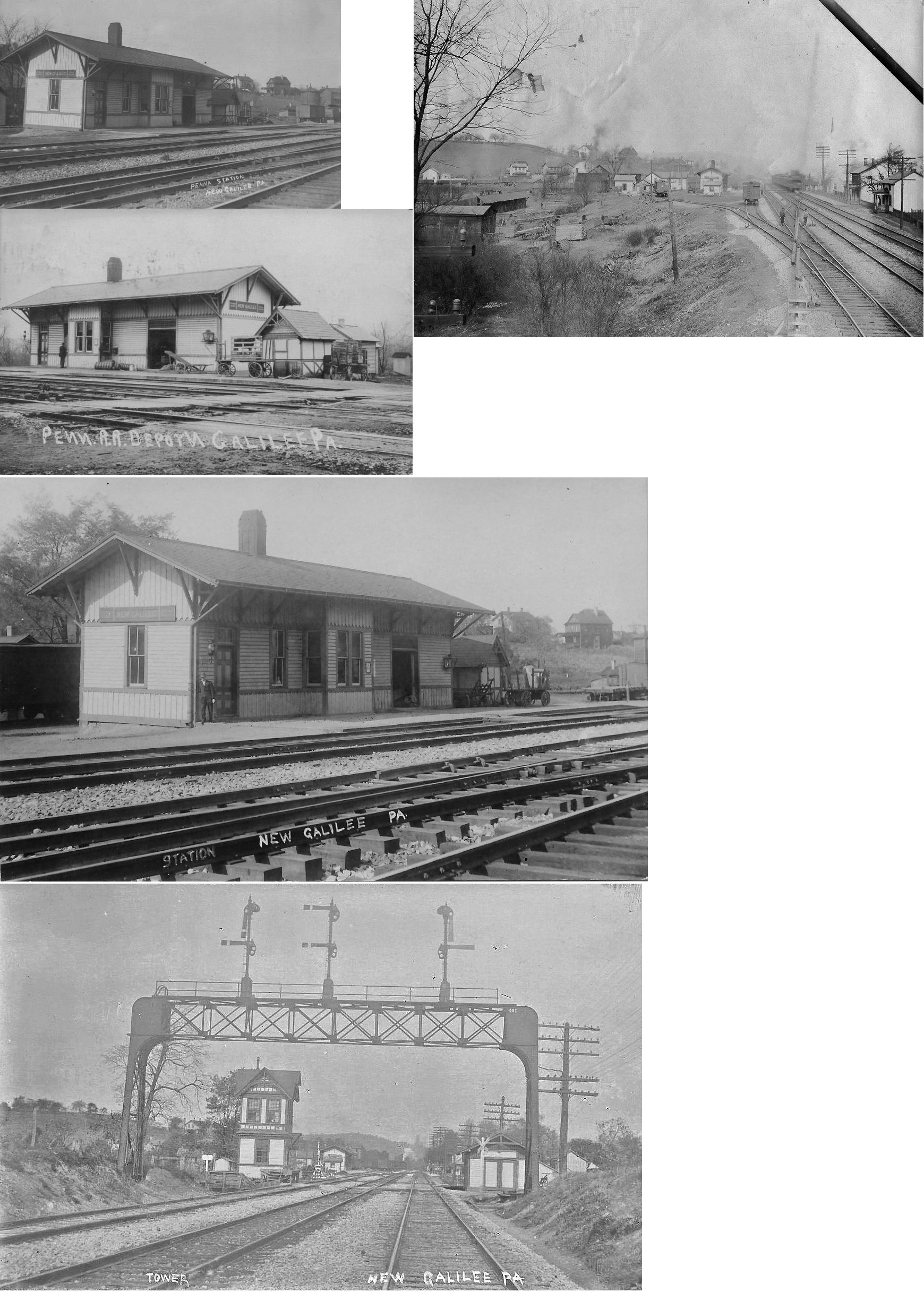
| New Galilee |
|
According to the 1876 map, the first station here was on the north side of Monroe Street on the west side of the tracks (GPS: 40.835015,-80.402198). | ||||||
| New Galilee |
 |
|||||||
| New Galilee | |
|||||||
| Newport | |
|||||||
| Redstone |
|
This was an early station between Economy and Woodlawn. | ||||||
| Remington |
|
This station was between Baden and Conway. | ||||||
| Riverside | |
This station was one mile from New Galilee and 1.2 miles from Darlington. | ||||||
| Rochester (Bridgewater) (Beaver) |
|
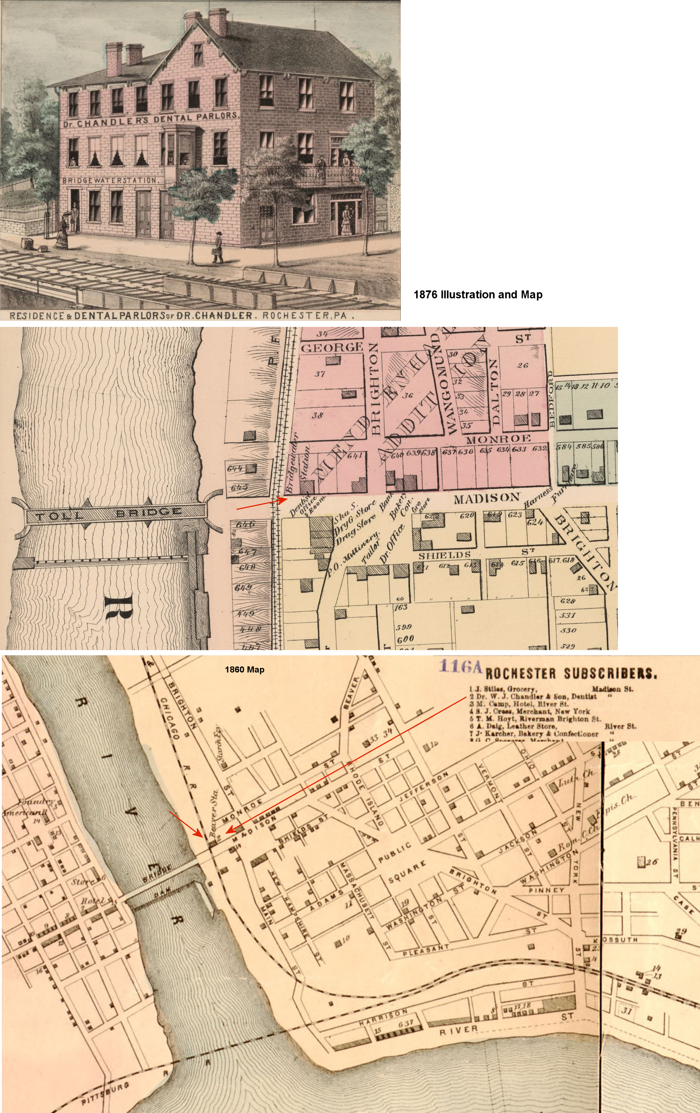
This station was alternatively known as "Beaver" and "Bridgewater." The first station here was on the north side of Madison Street at approximately GPS: 40.701870, -80.290174. The station was on the first floor of the three-story residence/dentist office of Dr. W.J. Chandler. It is shown on the 1860 and 1876 maps. Later, the railroad built its own station and changed the name at some point to West Rochester. It was known as "Bridgewater Station" and "Beaver Station" because it was not in those locations proper. Railroads would often append the word "station" to the official name of the station to indicate that it was nearby a town/city, but not directly in that town/city. | ||||||
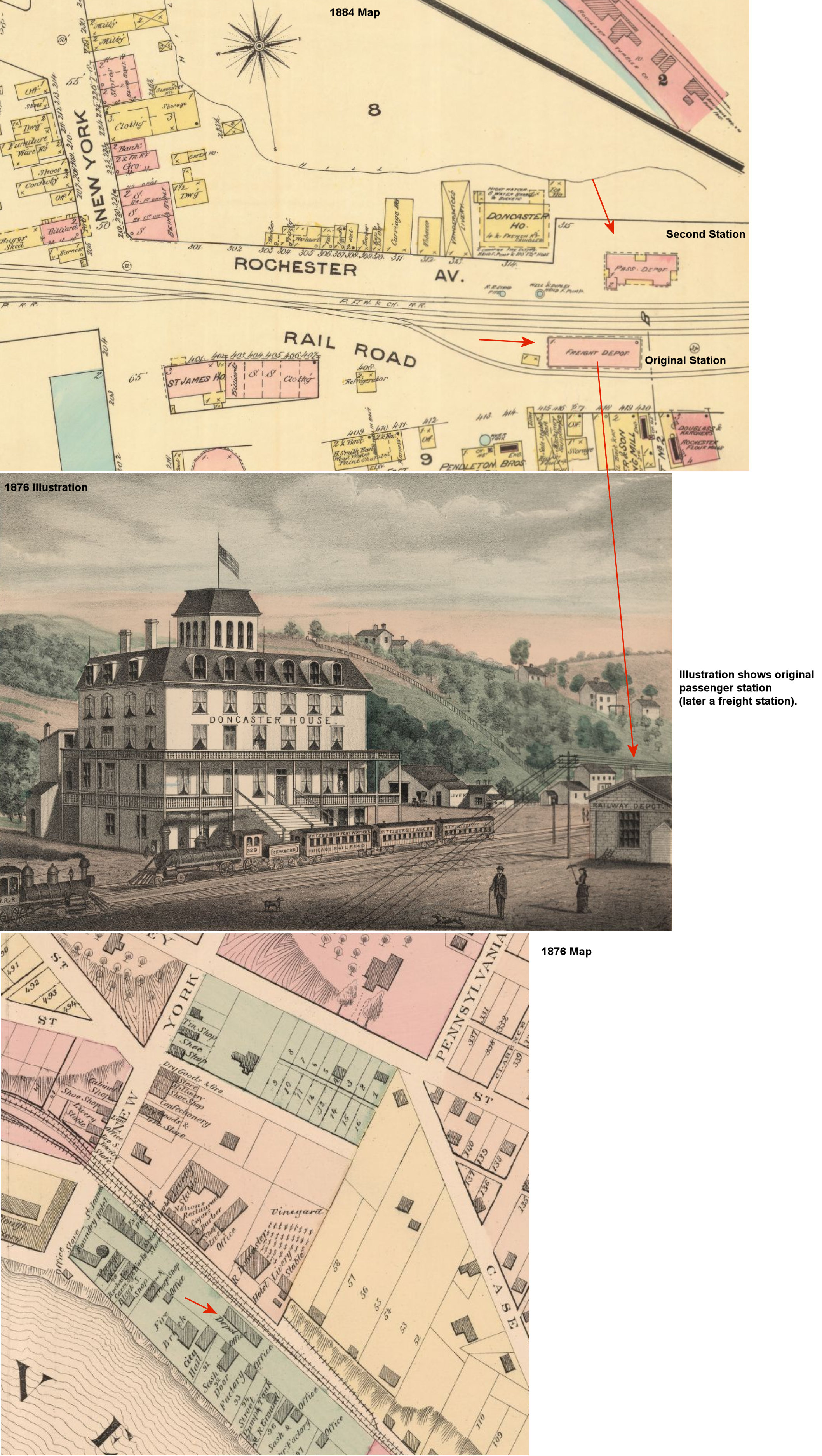
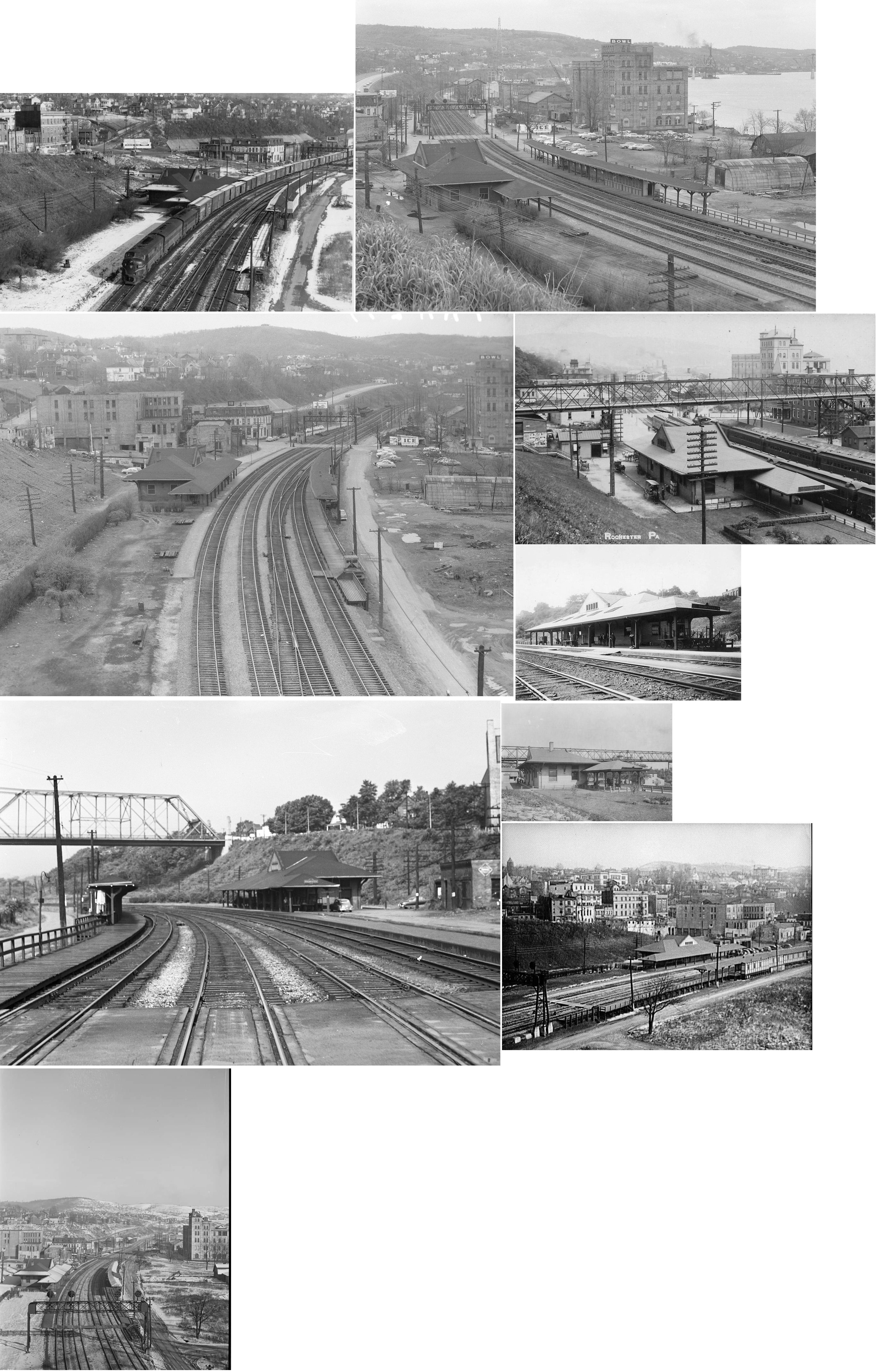
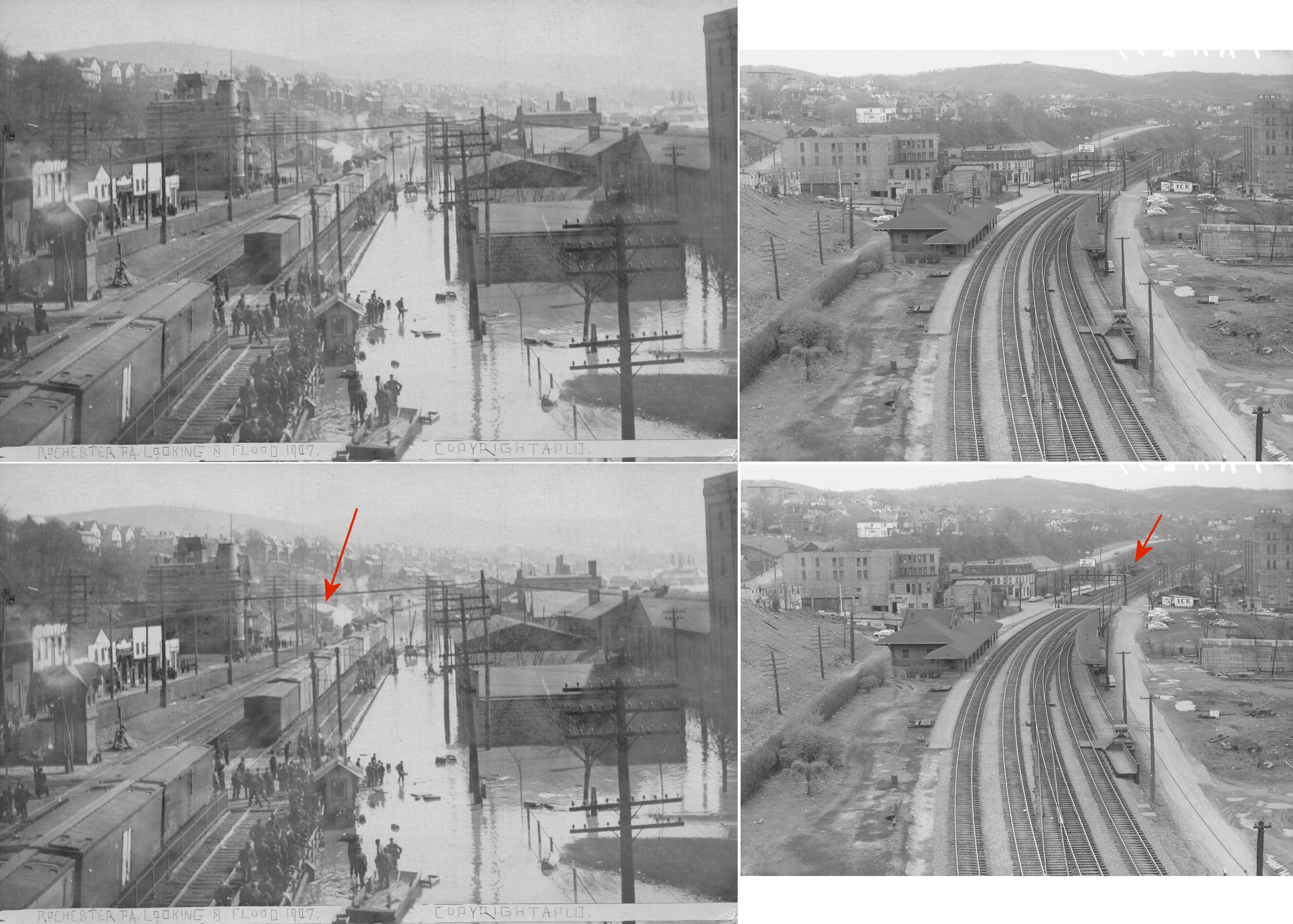
| Rochester |
|
The original brick station here was across the tracks from the old Doncaster Hotel at GPS: 40.699111, -80.278495 as shown on the 1876 and 1884 map. Sometime between 1876 and 1884 a new passenger station was built on the north side of the tracks and the original station became a freight station. That freight station (original passenger station) was subsequently replaced by a frame freight station between 1884-1898 at the same location. Both the original passenger and second freight station were gone by the time of the 1903 map where a new passenger and freight station appear (see listings below). | ||||||
| Rochester |
|
A new passenger station was built in 1880 across the tracks from the original station. It was on the north side of the tracks below where PA51 is today at GPS: 40.699355, -80.278447. The station was made of brick. Although this station still appears on the 1898 map, it is marked "to be removed." The original brick freight station was across the tracks at GPS: 40.699111, -80.278495 as shown on the 1884 map. That brick freight station was replaced by a frame freight station between 1884-1898 at the same location. Both the original passenger and second freight station were gone by the time of the 1903 map where a new passenger and freight station appear (see listings below). | ||||||
| Rochester |
|
This station was below Pleasant Avenue and PA51 at GPS: 40.699678, -80.281916. It was built in 1899 according to the PRR Annual Report of that year. | ||||||
| Rochester |
|
There was a frame freight station on the north side of the tracks on a couple of siding tracks. It would have been where PA51 is now at approximately GPS: 40.699479, -80.277301. It was built around 1898. | ||||||
| Rochester (W. Rochester) |
|
The 1945 PRR timetable lists this station as being at the junction with the New Brighton Industrial track less than a mile from the Rochester station at MP 26.3 (the Rochester station was at MP 25.8). There was also a West Rochester freight station at MP 28.4. | ||||||
| Smiths Ferry | |
According to PRR valuation records, this station was built in 1865. It would have been along what is now Midland Road (PA68) at approximately GPS: 40.647504, -80.500793. | ||||||
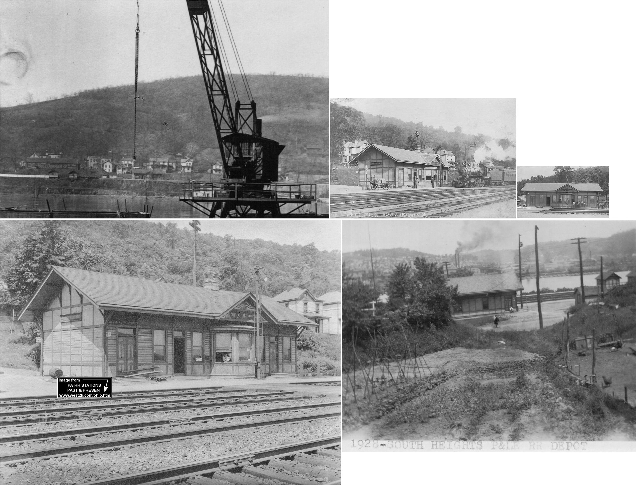
| South Heights (Shannopin) |
|
South Heights was known as Shannopin until 1909. There was an original station here before this one that sat along PA-51 (Jordan Street). It's possible that the old station was torn down and the new one built when the tracks were moved down to their current river location in 1907. The tracks from Woodlawn to Stoops Ferry on the P&LE were moved when the J&L Steel mill property was graded in 1907. The railroad upgraded from one track to four, tore down the steel trestle that spanned Woodlawn Valley, and then created a massive fill to lay the new track. However, the P&LE valuation records list the date built for this station as 1891, so it may be the original station was moved onto the new alignment. | ||||||
| Thompson |
|
A station is listed here on the 1923 PRR List of Stations & Sidings. | ||||||
| Vanport | |
|||||||
| Walnut |
|
A station is shown here on the 1923 PRR List of Stations & Sidings. It was about two miles from Highland and two miles from New Galilee. Interlocking tower "WU" was .2 mile from the station. | ||||||
| Watts Mill | |
This station was at milepost 6.4 between West Darlington (MP 7.0) and Cannelton (MP 5.1). Mileposts are distances from New Galilee. | ||||||
| West Bridgewater |
|
The station was at the foot of Mulberry Street near West Bridgewater Steel. The station is shown on the 1899 and 1904 maps. The station caught fire in June, 1906, but the damage was only minor as the fire department quickly extinguished the flames (The Beaver Times, 6-15-1906). The station went out of service in 1908 (New Castle News, 2-26-1908). | ||||||
| West Darlington (Devon) |
|
This station was near the state line. It was between Negley (OH) and Watts Mills at milepost 7.0 (from New Galilee). | ||||||
| West Economy | |
|||||||
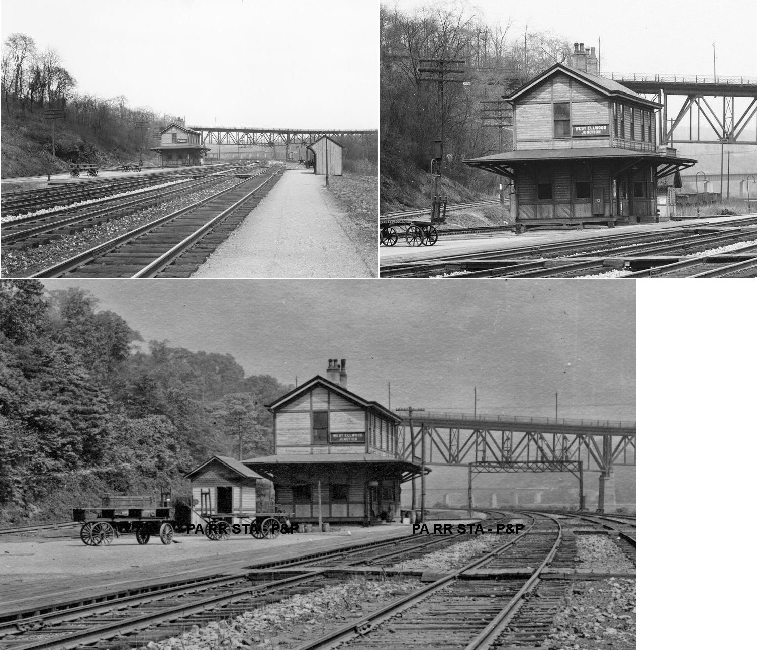
| West Ellwood Junction | |
This station was on the west side of the Beaver River just NE of Koppel on the south side of the old PA351 bridge in the vicinity of GPS: 40.839994, -80.317068. | ||||||
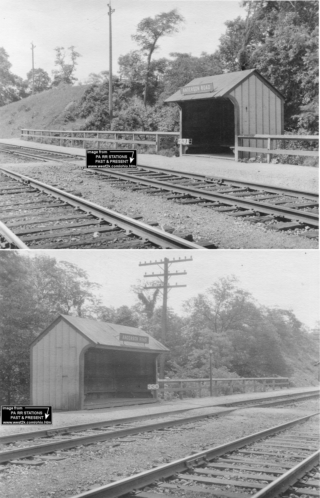
| Wireton (Anderson Road) |
|
This station was right near the border of Beaver and
Allegheny Counties. Prior to the regrading of the tracks for the P&LE RR,
Anderson Road was the Wireton stop. It was located approximately where
St. Catherine of Siena Church is now at the intersection of PA-151 and
McGovern Boulevard (GPS:
40.568984, -80.233215). There were two twin shelters there - one on
each side of the tracks. They were built in 1895 in McKeesport and then
moved to Anderson Road in 1911 according to P&LE valuation records. All of the streets in that area were ripped out when the Duquesne Light Phillips Power Plant was built in the late 1930s. There were several rows of homes and businesses, including the Rooney Hotel founded by the grandfather of Pittsburgh Steelers founder Art Rooney. When they took out the Anderson Road stop, all traffic for the railroad including mail drops were diverted to the Glenwillard (Shousetown) station (Info in this paragraph courtesy of the Crescent-Shousetown Historical Association). |
||||||
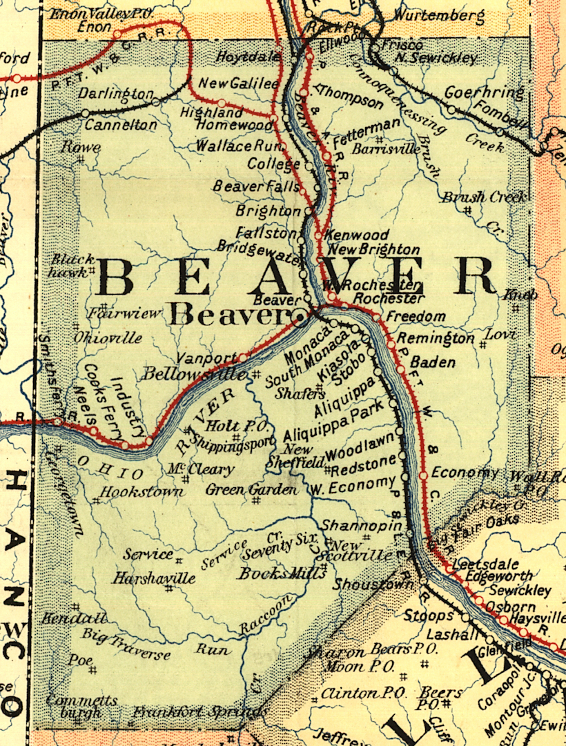
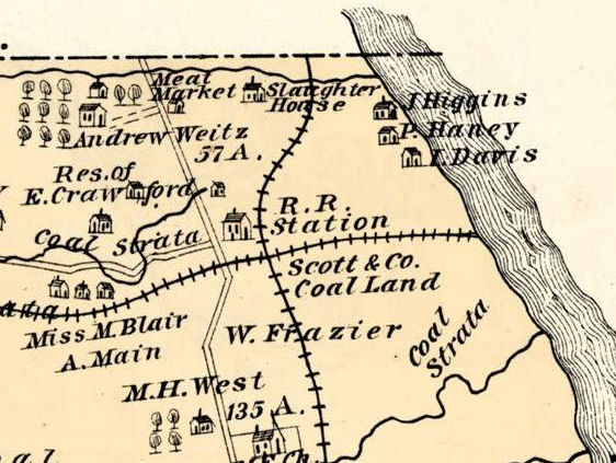
| 1895 BEAVER COUNTY RAILROAD MAP | ||||||||
 |
||||||||
| Notes About Existing
Stations... Aliquippa (West Aliquippa) (P&LE) - This station is shown on the 1912 Sanborn map of Aliquippa and P&LE records confirm that as the build date. There was a tunnel under the tracks that led from 3rd Street near the freight house (the earlier passenger station) for access to this passenger station which was a block south of the tunnel. Darlington (NYP&C) - The New York, Pittsburgh & Chicago (NYP&C) was the predecessor to the Pittsburgh, Lisbon & Western (absorbed by the Youngstown & Southern in 1945). Despite its name the railroad only went from Pittsburgh to Youngstown, OH. This is the former Greersburg Academy building. The town was originally called Greersburg but there was too much confusion with Greensburg, with mail being delivered to the wrong place, so they renamed it Darlington. In 1853 the Darlington Cannel Coal Railroad (later NYP&C) laid tracks within six feet of the Academy. In 1883, the Academy building was sold to to the Pittsburgh, Marion and Chicago Railroad Company (later NYP&C). The building was renovated to become a railroad station as four passenger trains a day shuttled the nine miles between Rogers and New Galilee. This is one of the oldest buildings to ever be used as a RR station and is on the National Register of Historic Places. It was retired from RR use in 1972 and subsequently became a historical landmark and is now a museum as part of the Little Beaver Historical Society. Homewood (PRR) - Built in 1852, this was the first station at Homewood (and the only one that has survived). It was primarily used as a hotel and tavern (Originally the Johnston House, later the St. Cloud Hotel, and later the Valley Inn), but train tickets could be bought in the bar area. This was done until 1864 when a permanent station was built by the RR across the tracks. As of 2026 the building is almost collapsed and not salvagable. Monaca (Colona) (P&LE) - Originally P&LE officials planned to build a new station at Monaca in 1910 and take the Colona station out of service with the new Monaca station intended to serve both towns like the Beaver Falls/New Brighton station. However, it was decided that since the existing brick station at Colona was relatively new, it would be hauled up the tracks to the newly acquired Monaca plot. This happened in 1910. The station still has the word "Colona" in the exterior masonry. The station's original location in Colona was in the general vicinity of GPS: 40.677380, -80.260035 near where the Aliquippa CSX yard office is today (2019). Monaca (P&LE) - This was the original station here. It was originally on the east side of 6th Street. Now used by the Beaver County Model RR Club and covered with faux-brick siding. This station was replaced by the "new" station (moved from Colona) around 1910. New Brighton (PFt.W&C) - The northeastern first floor part of this building was the original station here and was built "around 1850" (date from the NRHP file), but possibly as early as 1845. It was closed by 1880 when a new station was built at 5th Avenue and 14th Street (with that station being subsequently replaced when the tracks were moved down by the river in 1926). Edward Dempster Merrick purchased the one-story station after its closing to house his collection of artwork and paintings. Over the years, more additions were made to the original station building, including a second story. The complex of buildings and additions is now the Merrick Art Gallery and has been on the National Register of Historic Places since 1980. |
||||||||