|
|
||||||||
| EXISTING STATIONS | ||||||||
|---|---|---|---|---|---|---|---|---|
| Station Name |
Original Railroad |
Current Location |
Type | Current Use |
Date Built |
Track Status |
Building Material |
More Info |
| Kittanning |
 |
North Grant Street at Vine Street (GPS: 40.818675,-79.520183) |
P | Storage | 1895 | Gone | Brick | |
| Kittanning |
|
Reynolds Avenue between North Grant and Union Way (GPS: 40.818691, -79.519869) |
F | ???? | 1895 | Gone | Brick | |
| Kittanning (Applewold) |
 |
River Road on west side of old Kittanning bridge (GPS: 40.811712, -79.524920) |
P | Civic | 1913 | In Use | Brick | |
| Kittanning (Applewold) |
|
River Road on west side of old Kittanning
bridge. (GPS: 40.812320, -79.525390) |
F | ???? | 1913 | In Use | Wood | |
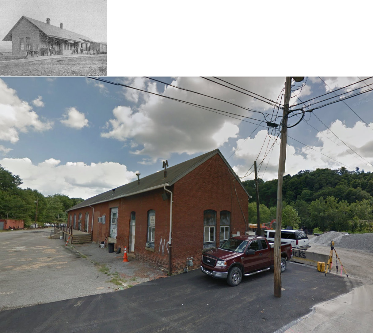
| Leechburg |
 |
2nd Street at River Street (GPS: 40.625811, -79.605703) |
C | Railroad | 1887 | Gone | Brick |
|
| Schenley |
 |
Railroad Street (GPS: 40.684066, -79.662988) |
P | Railroad | 1998 | Gone | Wood |
|
| Yatesboro |
 |
NE corner of Industrial and 2nd Streets (GPS: 40.799485, -79.334082) |
C | Residence | ???? | Gone | Wood | |
| STATIONS OF THE PAST | ||||||||
| Station Name |
Original Railroad |
Notes | ||||||
| Adrian | |
|||||||
| Aladdin |
 |
This station is shown on the 1923 PRR List of Stations & Sidings. | ||||||
| Apollo |
|
This brick combination passenger/freight station was on the north side of 1st Street on the east side of the tracks (GPS: 40.581617, -79.567427). In the late 1890s this station became a freight-only station with the station across the river in West Apollo (Westmoreland Co.) serving as the passenger station. For a short period, service was suspended to this station as the railroad bridge across the river on the north side of town fell into disrepair and the RR planned to abandon it (this bridge was located at GPS: 40.587400, -79.568605). A delegation from the town travelled to Philadelphia to meet with RR officials to plead their case to keep train service to Apollo. The RR agreed and a new bridge was constructed south of town (located at GPS: 40.571501, -79.564367) (see page 60 of the book "1816-1916; History of Apollo, Pennsylvania: The Year of a Hundred Years" by Thomas James Henry for a discussion of RR service to the town). In 1915 the station is once again listed on maps as a passenger/freight station. | ||||||
| Apollo (Paulton) (West Apollo) |
|
This frame combination passenger/freight station was near where Orr Avenue meets PA66 at approximately GPS: 40.577864, -79.569225 (in Westmoreland County). In the late 1890s a new frame station was built here next to the original station and this new station became a passenger-only station with the station across the river in Apollo (Armstrong Co.) serving as the freight station. The name of the station was officially changed by the PRR from Paulton to West Apollo in 1901. According to the 1904 map, both the old station and the new station co-existed for a brief time with the old station serving as storage. The original station was gone by the time the 1909 map was published. | ||||||
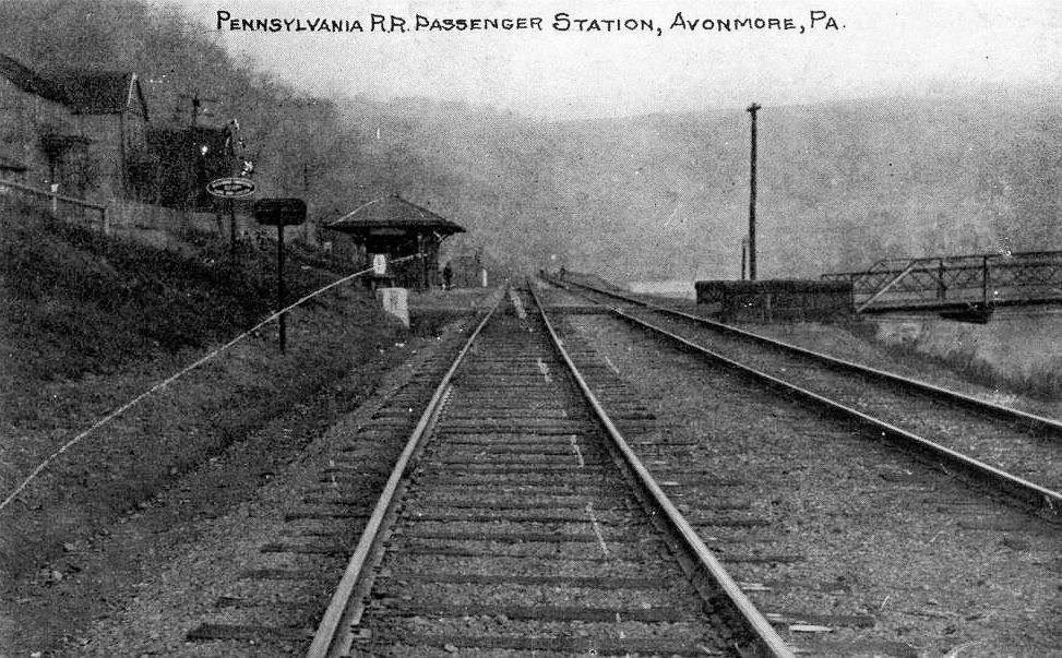
| AvonmorE Station | |
The passenger station was across the river from Avonmore in Armstrong County in what was then called North Avonmore. The location was at the end of the present bridge where the road is now. During the early 1950s the tracks were realigned all the way from Blairsville to Salina during the construction of Conemaugh Dam. The old road bed is the current road to the coal loading facility owned by Rosebud Coal. There was a freight station in the borough of Avonmore (it was two miles from the passenger station across the river), but no passenger station in town. The borough of Avonmore was accessed by the short Avonmore Branch. | ||||||
| Bagdad | |
This station is listed on the 1923 PRR List of Stations & Sidings. | ||||||
| Barge |
|
|||||||
| Boggsville |
|
|||||||
| Brady's Bend |
 |
|||||||
| Bridgeburg |
|
|||||||
| Cadogan |
|
|||||||
| Cherry Lane |
|
This station was just south of Apollo. | ||||||
| Chickasaw |
|
This was on the Tidal Branch. | ||||||
| Clinton |
|
|||||||
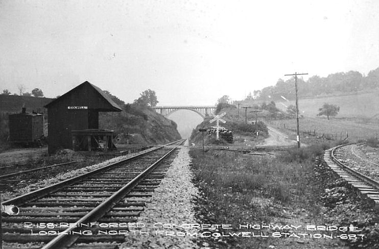
| Colwell Station |
|
|||||||
| Cowan (Cowansville) |
|
This station was built in 1901. | ||||||
| Cowanshannock |
|
The one-mile Cowanshannock Branch started near the station. | ||||||
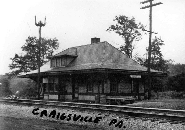
| Craigsville |
|
|||||||
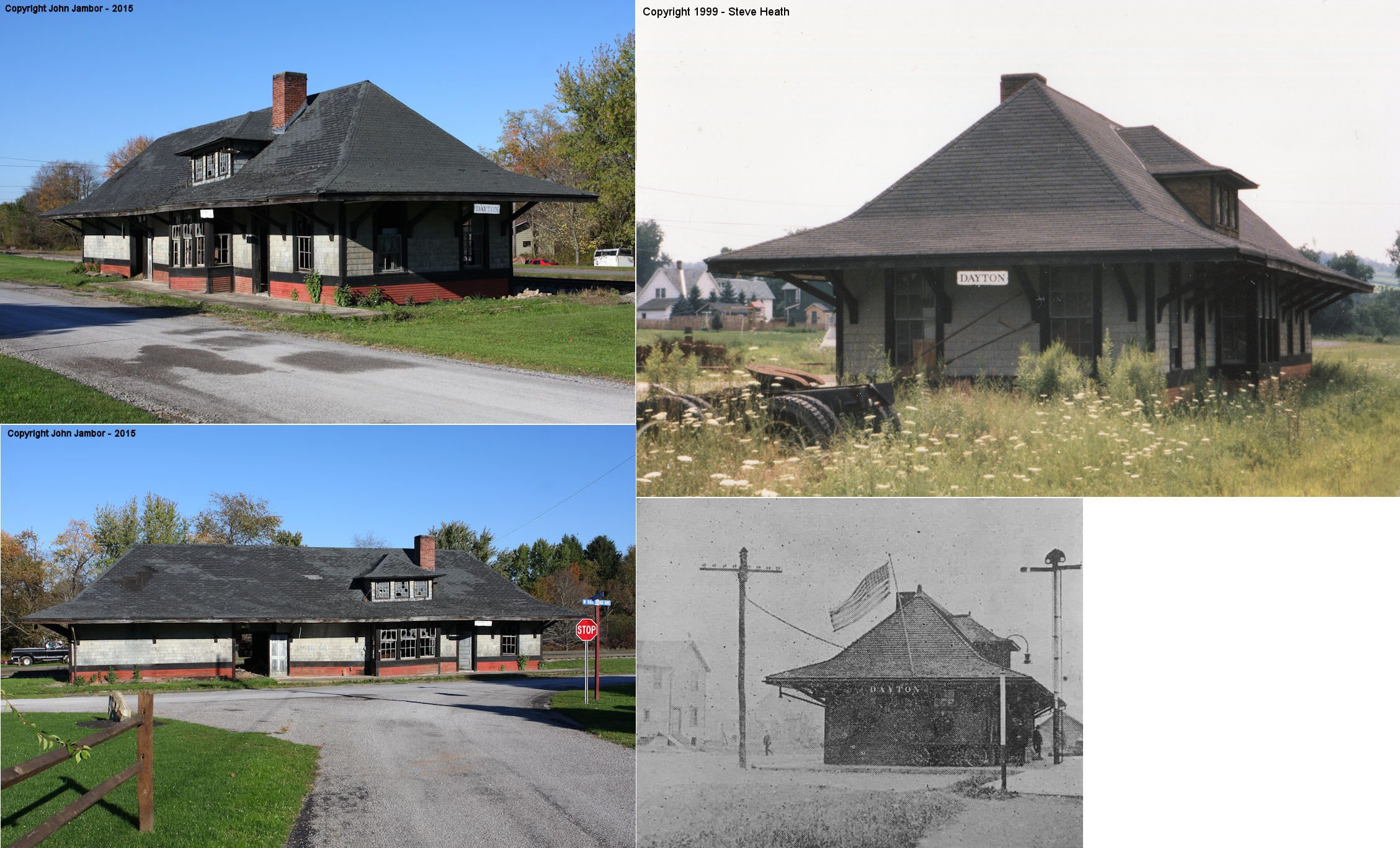
| Dayton |
|
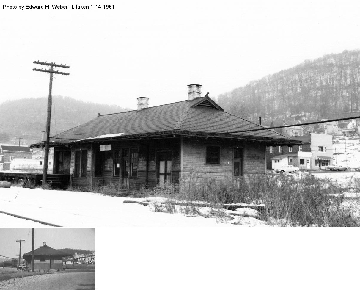
This station, built in 1899, was at the corner of Railroad Avenue at North Poplar Street at GPS: 40.882242,-79.244326. It was closed by the railroad in October, 1955. After service it was used by the railroad and then as an office for the P&N Coal Company. It was torn down in September of 2025. | ||||||
| Dewey |
|
|||||||
| Dickey |
|
|||||||
| Dock Hollow |
|
|||||||
| Donely's Station |
|
This was along the line just northeast of where Donely's Island is. | ||||||
| East Mosgrove |
|
This station burned on April 14, 1903 according to the Pittsburgh Daily Post (4/15/1903). The station agent, A.U. Howard, was seriously burned in the fire. | ||||||
| East Mosgrove |
|
|||||||
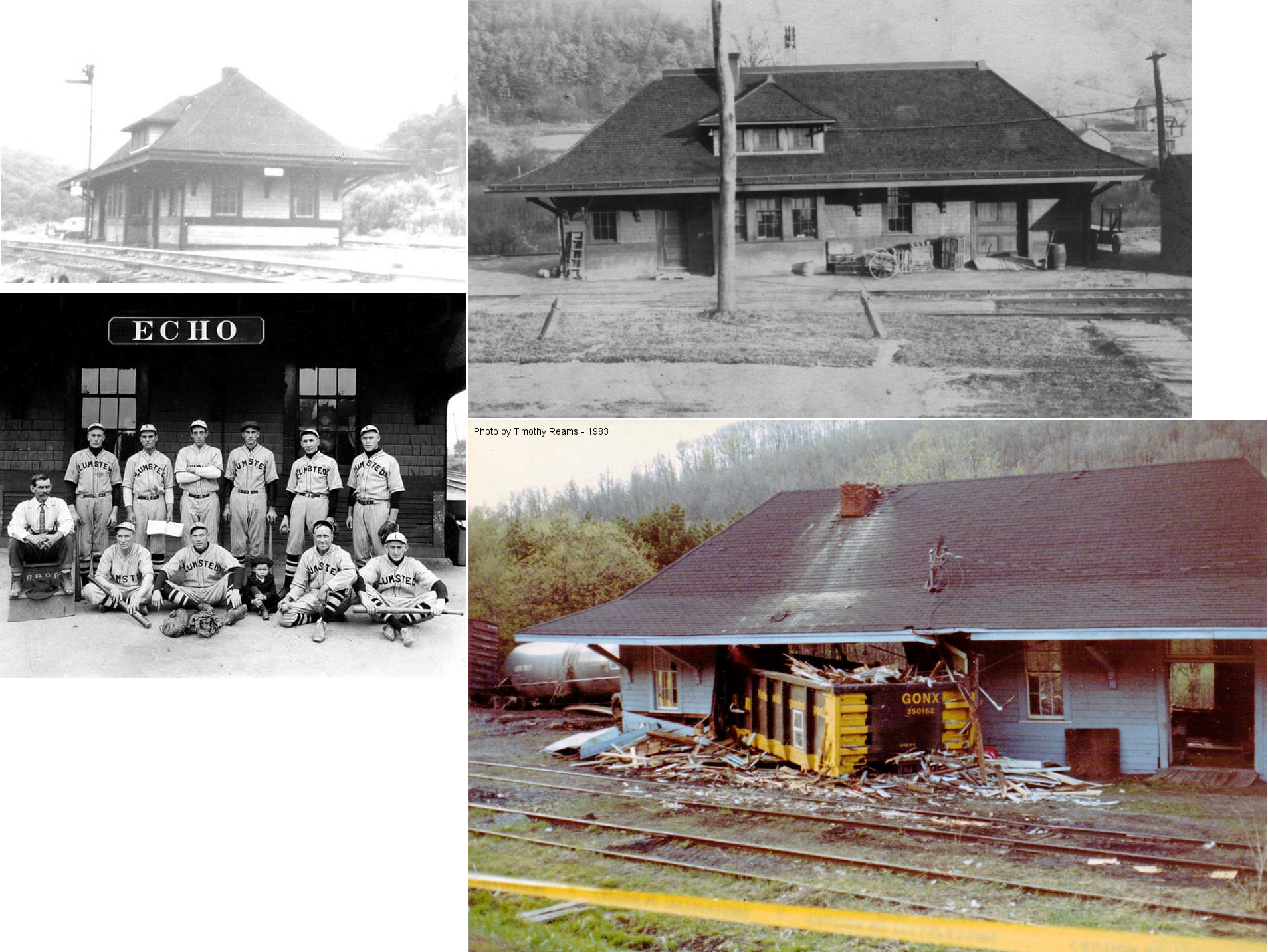
| ECHO |
AND Rural Valley RR |
This station, built in 1900, was demolished in a 24-car derailment on May 4, 1983 (Indiana Gazette, 5-4-1983). The freight agency here had just closed two months prior to the wreck. This station was also used by the Rural Valley Railroad which was owned by the BR&P. The station sat between the BR&P and RVRR tracks. | ||||||
| Eddyville |
|
|||||||
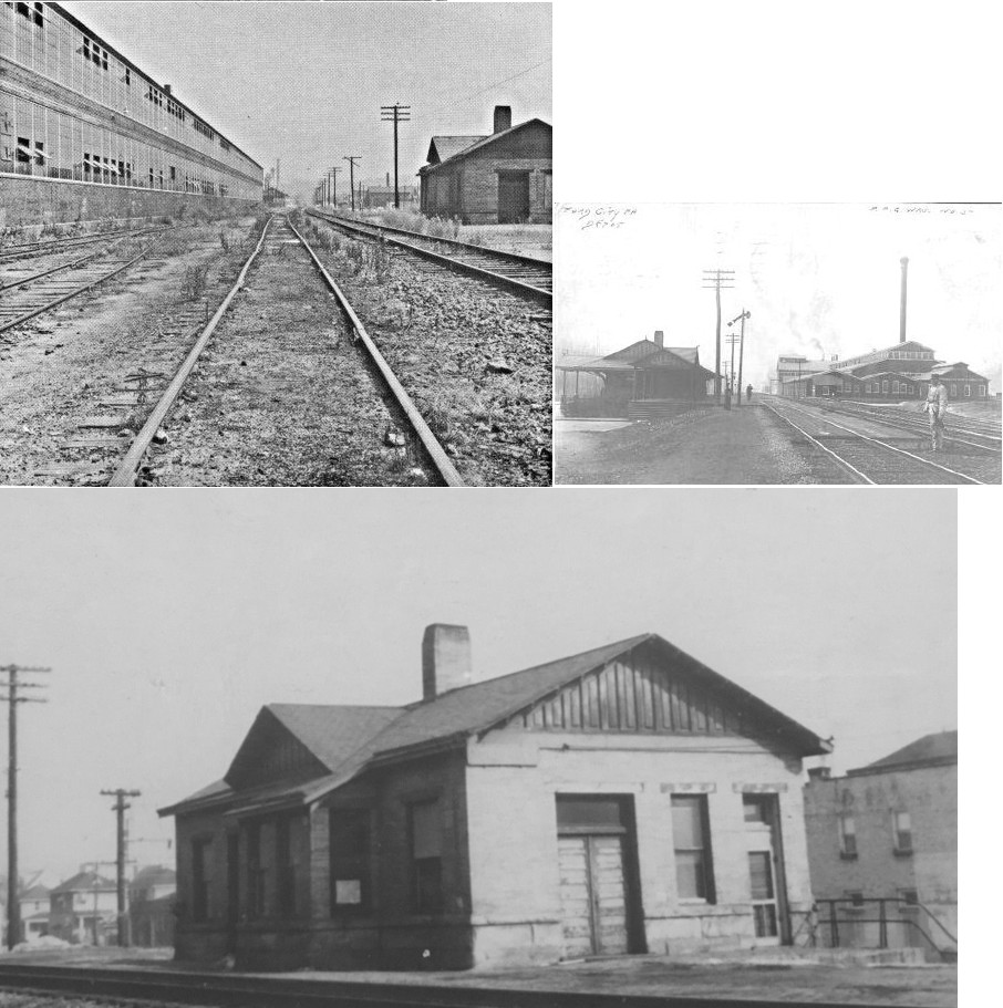
| Ford City |
|
The original brick combination station here was on 3rd Avenue just SW of 5th Street at GPS: 40.764951, -79.537831. When the new station was built sometime between 1900-1904, this station served as the freight station. It went out of service when the new freight station was built near 10th Street and was demolished soon after (sometime between 1913-1921). | ||||||
| Ford City |
|
This second-generation passenger station was on 3rd Avenue at the west end of Ford Avenue at GPS: 40.771164, -79.532474. The station survived at least until the late 1970s. | ||||||
| Ford City |
|
A brick freight station was built here in 1888. A new freight house with a brick head end and frame extension was built sometime between 1913 and 1921. It was located on 3rd Avenue between 10th Street and O'Connor Street (GPS: 40.771940, -79.531545). | ||||||
| Ford City (West Ford City) |
|
|||||||
| Freeport |
|
The original station was also known as Buffalo Station (it's called that on the 1876 map). It was on the south side of Buffalo Street on the east side of the tracks (GPS: 40.676301,-79.6913). This may have been the same station as the one below listed for Laneville. | ||||||
| Freeport |
|
This station was on the west side of 3rd Street on the north side of the tracks (GPS: 40.671745, -79.687869). | ||||||
| Freeport (Laneville) |
|
There was a small station or shelter on the Butler Branch near the site of the old Imperial Tannery at the west end of the Buffalo Street bridge (no longer there) on the east side of the tracks at GPS: 40.676476, -79.691177. There was a grocery store next to the small station. It is shown on maps from 1886-1902. It was replaced by the station listed below. | ||||||
| Freeport (Lane Station) |
|
Sometime between 1902-1908 more siding tracks were installed and the original station was torn down to make room for the new tracks (although the grocery store remained). A larger but still smallish station along with a freight house was built on the west side of the tracks at approximately GPS: 40.676570, -79.691260. On the 1906 map is it labeled as "Lane Depot." | ||||||
| Freeport |
|
|||||||
| Glen |
|
|||||||
| Godfrey |
|
|||||||
| Hill |
|
|||||||
| Hooks |
|
|||||||
| Iron Bridge |
|
|||||||
| Johnetta (White Rock) |
|
See entry below for White Rock. | ||||||
| Kaylor |
|
The WARR was later part of the B&LE. This station burned down on February 3, 1927 (The Evening News, 2-3-1927). | ||||||
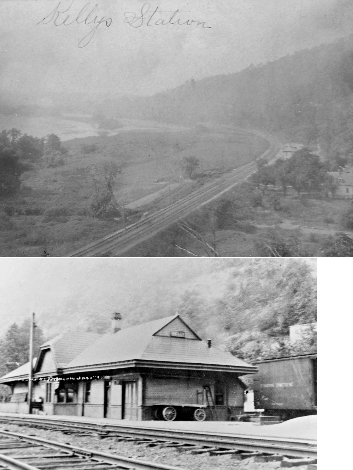
| Kelly's Station |
|
The station was named after Sheriff Hamilton Kelly, an old steamboatman, who was for years the station agent and postmaster here. | ||||||
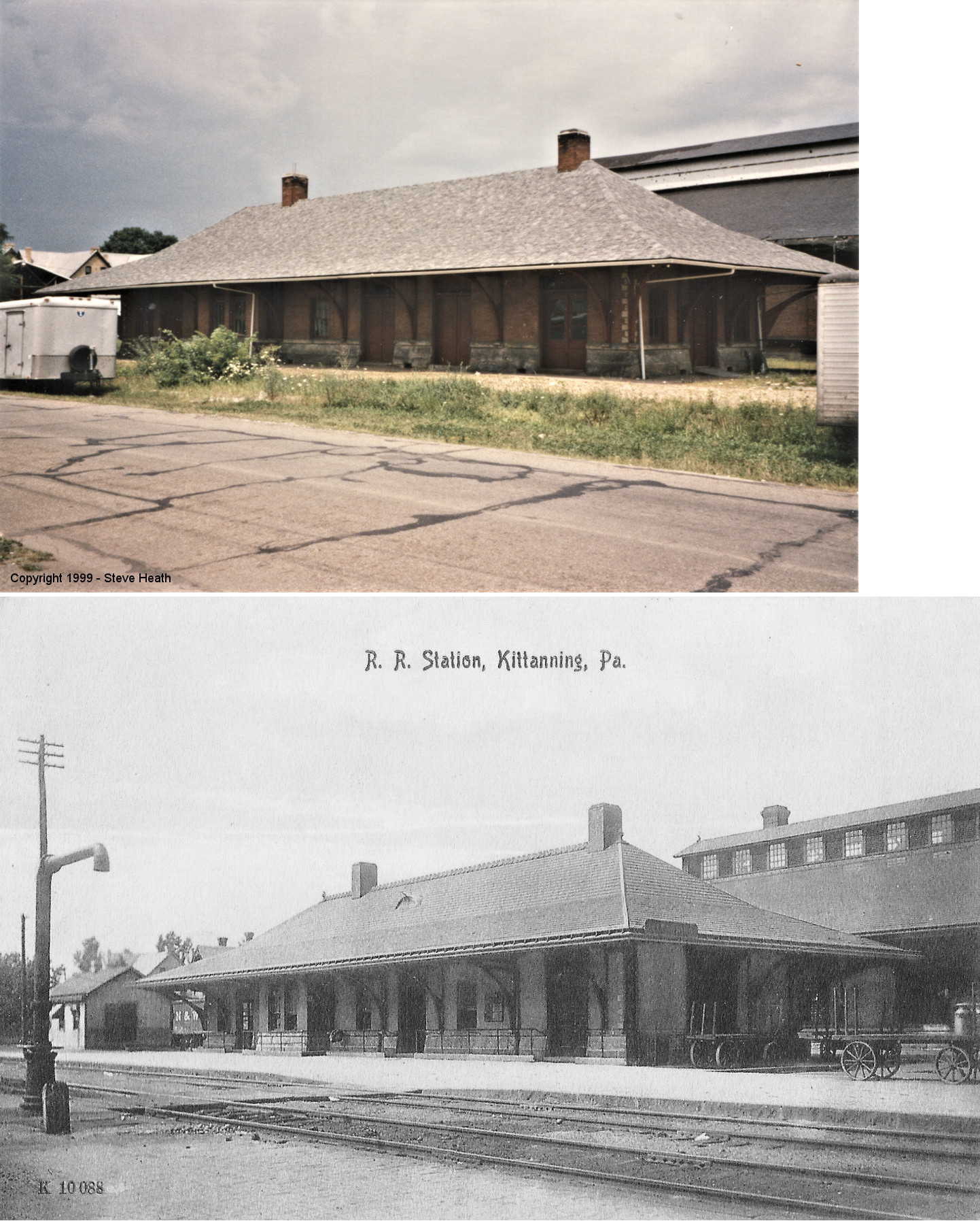
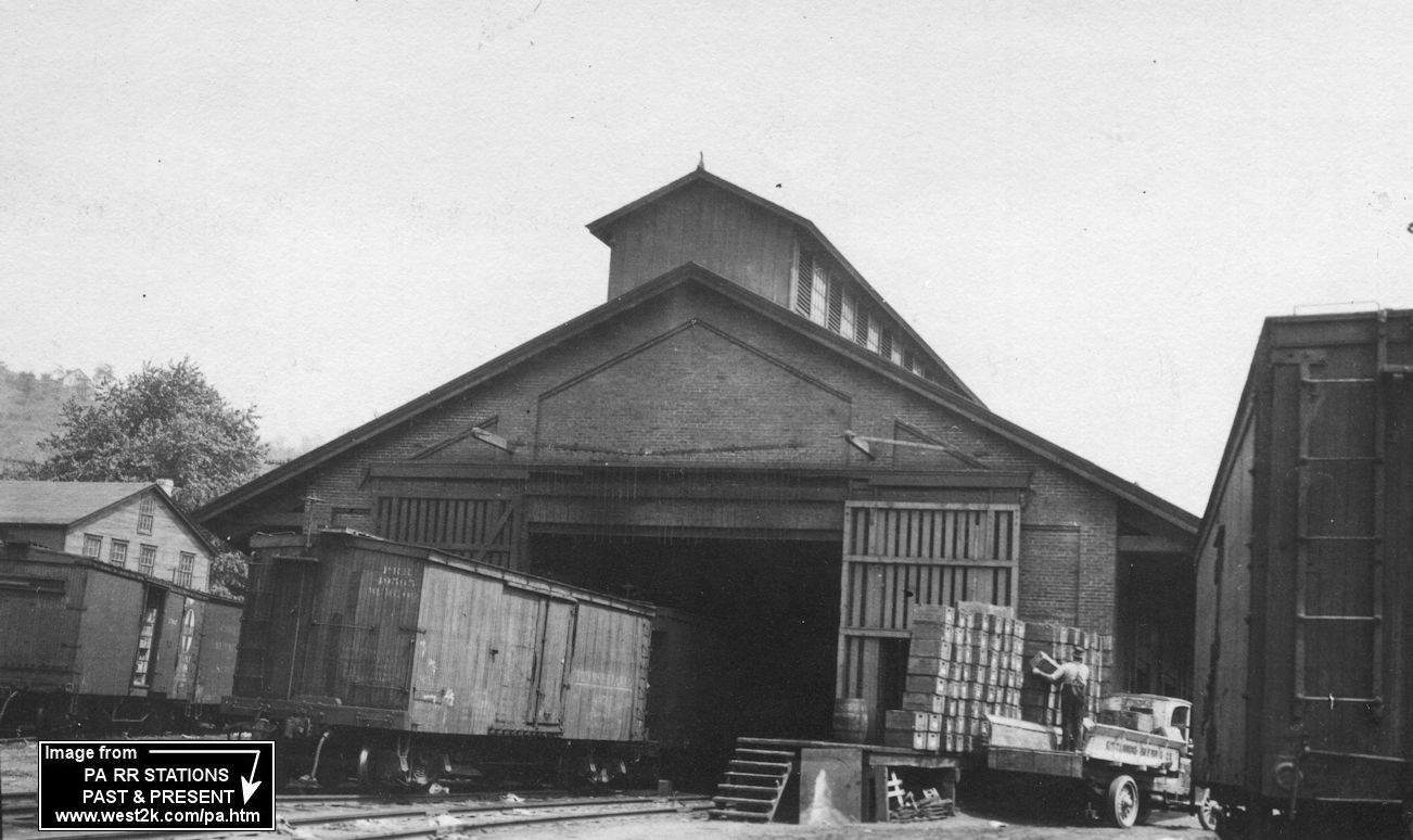
| Kittanning |
|
The first station was built here in 1856 on the south end of town. In 1866 the freight station was moved to the north end of town. | ||||||
| Kittanning |
|
The second station here was at the same location as the existing station. It was a combination station, but then a freight station was built behind it to the north sometime between 1886 and 1891. | ||||||
| Kittanning |
|
The freight station was built between 1886 and 1891 and was just NW of the original passenger station at GPS: 40.818935, -79.520500. This station was short-lived as both the original passenger station and this freight station were torn down by 1895 to make way for a new passenger station and a new, larger freight station to the east. | ||||||
| Knapp's |
|
|||||||
| Leechburg (W. Leechburg) |
|
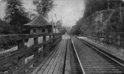
The second passenger station for Leechburg, was actually located across the Kiski River from Leechburg, in West Leechburg, Westmoreland County. The station was called Leechburg by PRR and was reached by the bridge that is shown in the picture. The foundation concrete and brick walks are still visible. The specific location was Bridge Street, West Leechburg. This station was built around 1904 after a flood destroyed the RR bridge at the eastern end of Leechburg, thus cutting off the town and its original 1887 station (which is still standing). | ||||||
| Logansport |
|
|||||||
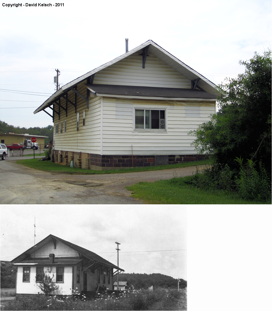
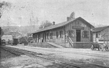
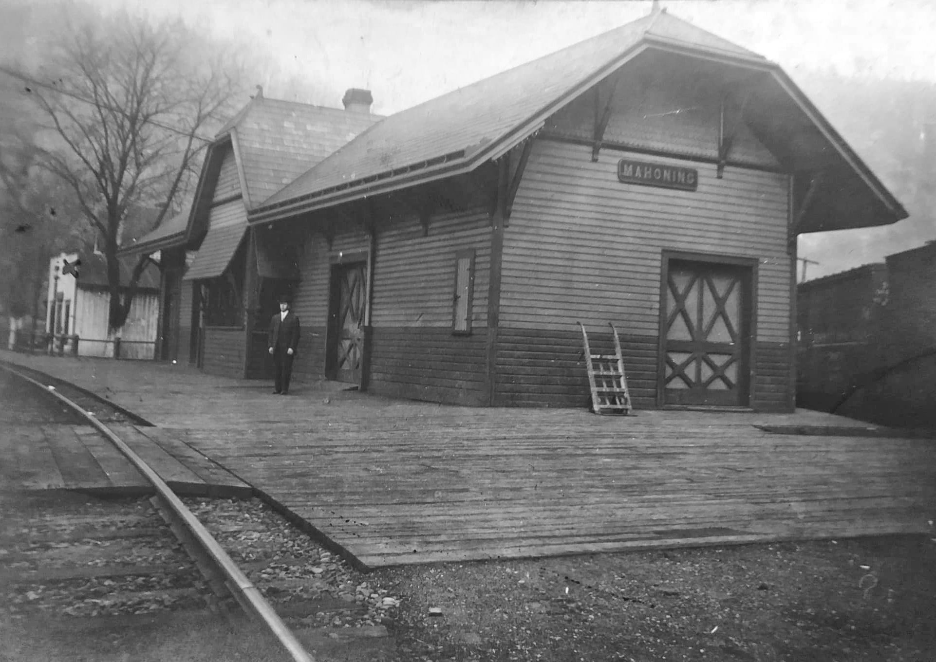
| Mahoning |
|
In 1876 the hotel and depot were in the same building. A new station (pictured) was built here in 1889. | ||||||
| Mahoning |
|
|||||||
| Manorville |
|
This station was on the south side of Mill Street on the east side of the tracks at approximately GPS: 40.787977, -79.519642. | ||||||
| Margaret |
|
|||||||
| Mc Williams |
|
|||||||
| Montgomeryville (Adrian) |
|
|||||||
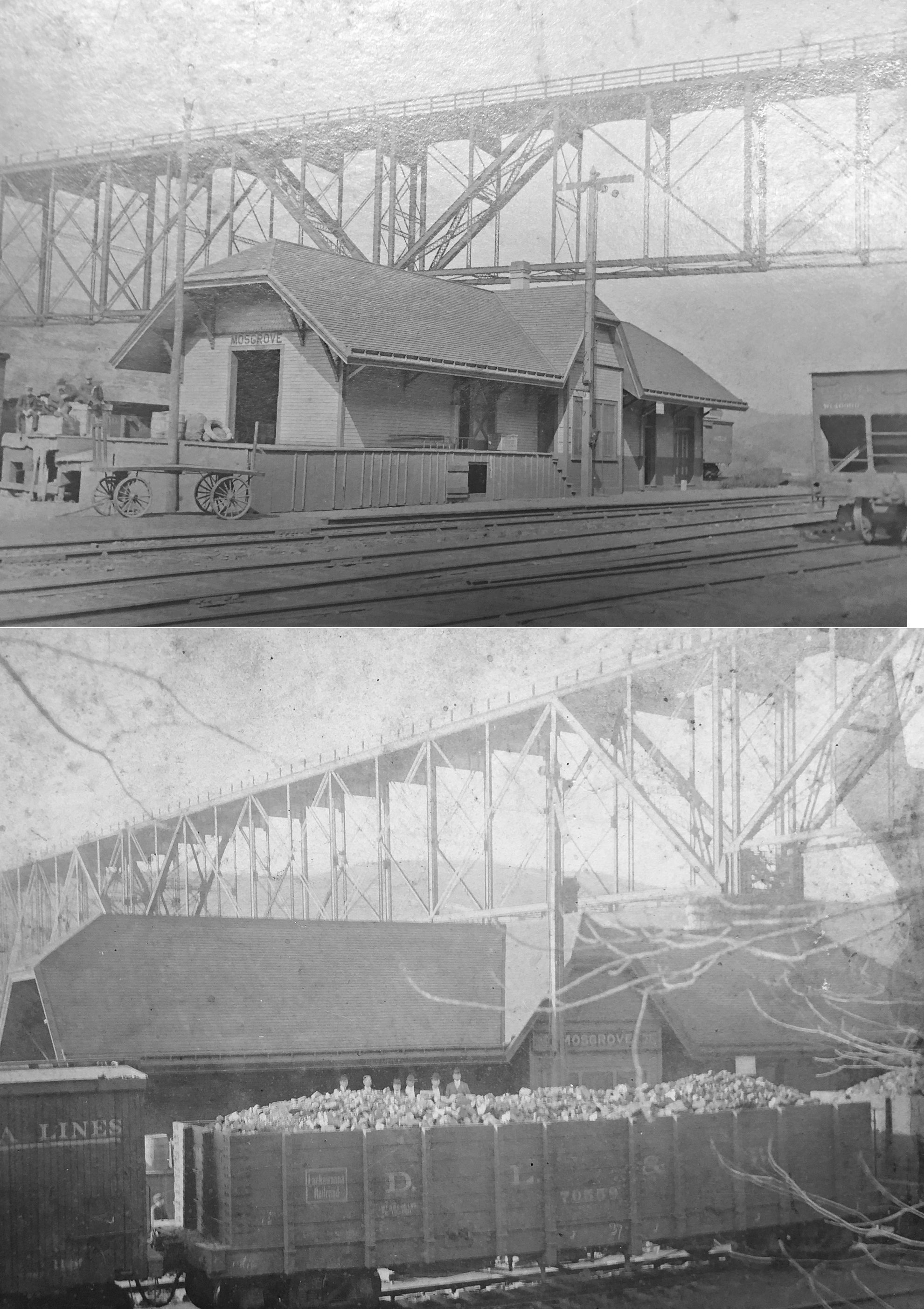
| Mosgrove (Brattonville) |
|
|||||||
| Nichola |
|
This station was built in 1902. | ||||||
| Nitro |
|
|||||||
| Nu Mine |
|
|||||||
| Oakhill |
|
This station is shown on the 1923 PRR List of Stations & Sidings. It was between Aladdin and Godfrey (about a mile from each) near the former location of the Oakhill Coal Company. There was likely only a passenger shelter here. | ||||||
| Oakland Junction |
|
|||||||
| Ore Hill |
|
This station is shown on the 1941 Armstrong County map between Mosgrove and Templeton. | ||||||
| Oscar |
|
|||||||
| Parker City (Parker) |
|
W.H. Spain was the agent here in 1876. The station was on the south side of 4th Street on the west side of the tracks. This station may have served the Parker & Karns City narrow gauge line (later part of the Pittsburgh & Western) as well. | ||||||
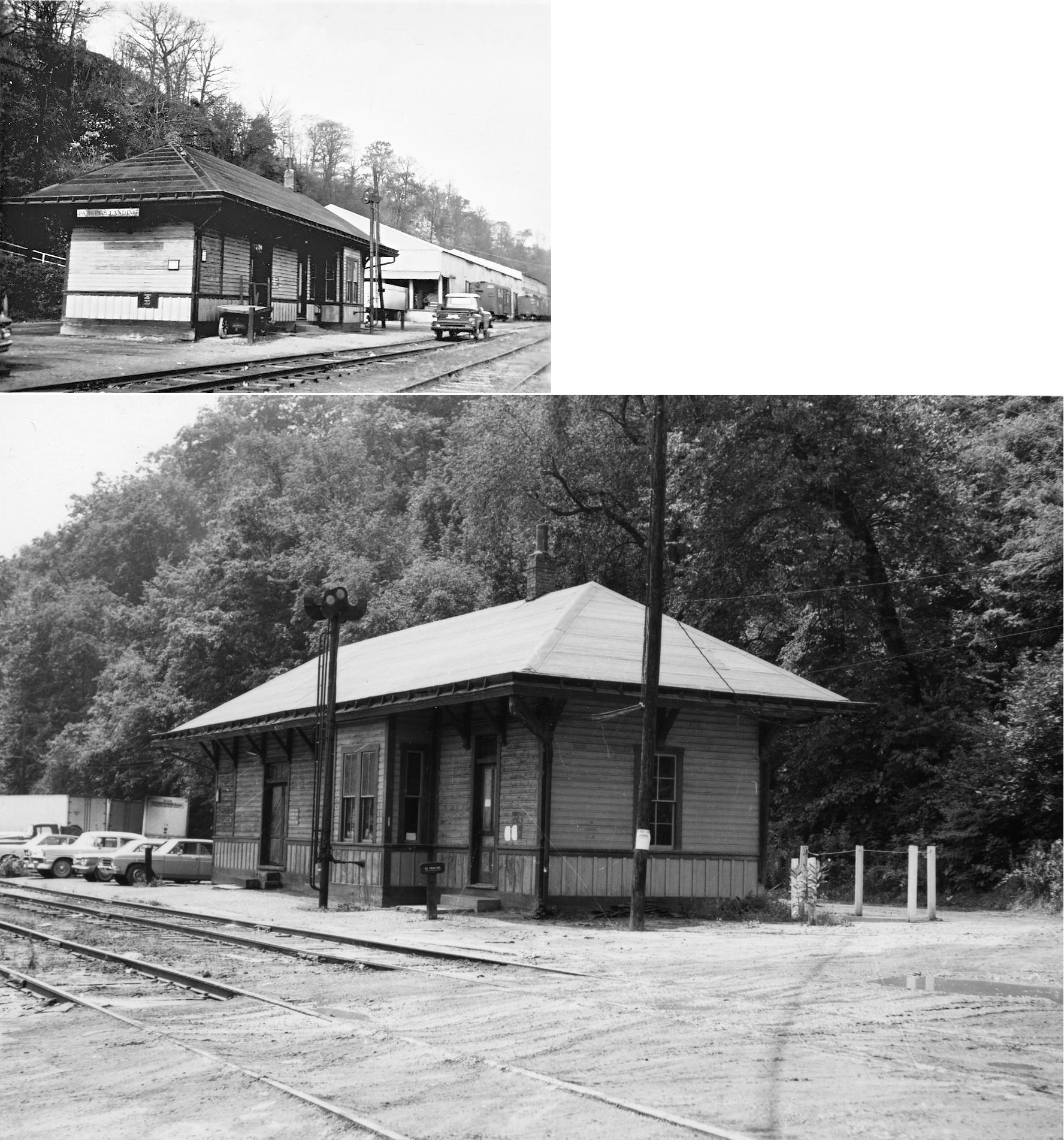
| Parkers Landing |
 |
This was the northern terminus of the P&KCRR as shown on the 1876 timetable. This railroad became part of the B&O. | ||||||
| Parkers Landing |
 |
In 1886 through 1910, a two-story station was on the west side of the tracks where Bluff Avenue crosses Central Avenue (the tracks ran down the middle of Central Avenue) at GPS: 41.097494, -79.681356. On the 1919 Sanborn map a one-story station is shown at the same site, so either a new station was built, or the original station was reduced (both buildings are shown to have the same footprint). | ||||||
| Peart's Eddy |
|
|||||||
| Pine Creek Station |
|
This station was just north of Mosgrove and is shown on the 1876 map. | ||||||
| Pine Furnace |
|
|||||||
| Reesdale |
|
|||||||
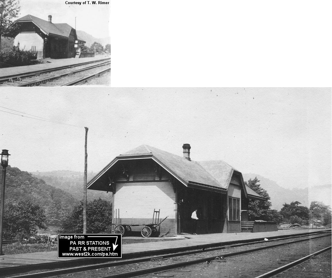
| Rimerton (Rimer) |
|
Station was torn down during WWII. | ||||||
| Rosston |
|
|||||||
| Rural Valley |
|
|||||||
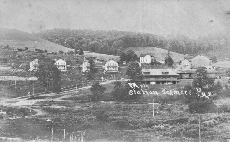
| Sagamore |
 |
The passenger station was located in the northwest quadrant of the crossing of the B&S main line and Post Office Road, approximately 800 feet southeast of the intersection of that road with Route 210 (GPS: 40.775986, -79.228208). It was a larger station by B&S standards, being perhaps the size of the station at DuBois. A freight station/house was located southeast on the opposite side of the tracks west of present-day Post Office Road and east of the main line on a short spur track, near GPS 40.775465, -79.227450. The passenger station does not appear in a 1939 aerial photo, but the freight station/house was still present at that time. These two stations were the southernmost on the B&S (and later B&O) branch from Juneau to Sagamore. --Nick Puzak | ||||||
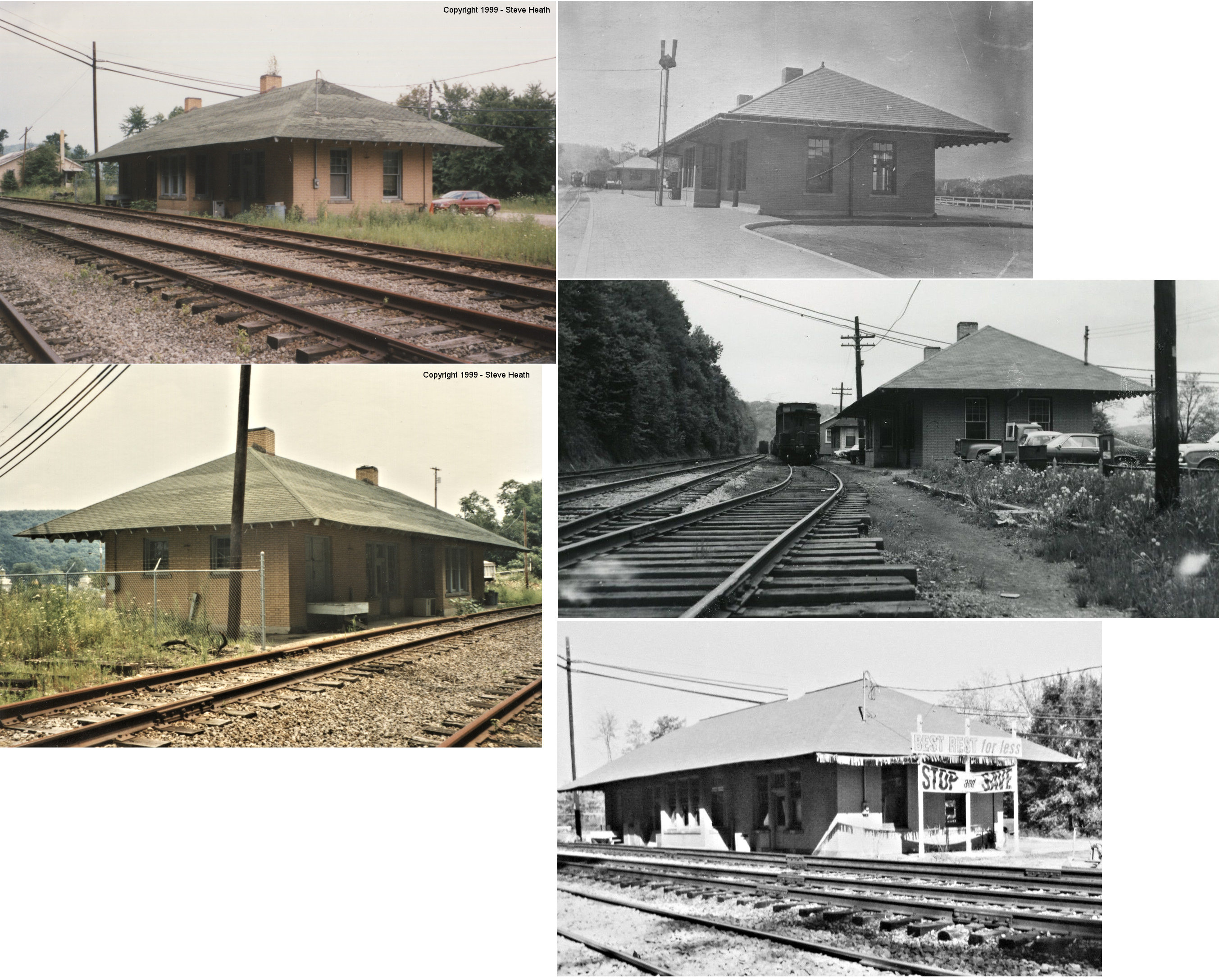
| Schenleys Station |
|
A. Tripp was the station agent here in 1876. It was located near the north end of Railroad Street near GPS: 40.684066, -79.662988. | ||||||
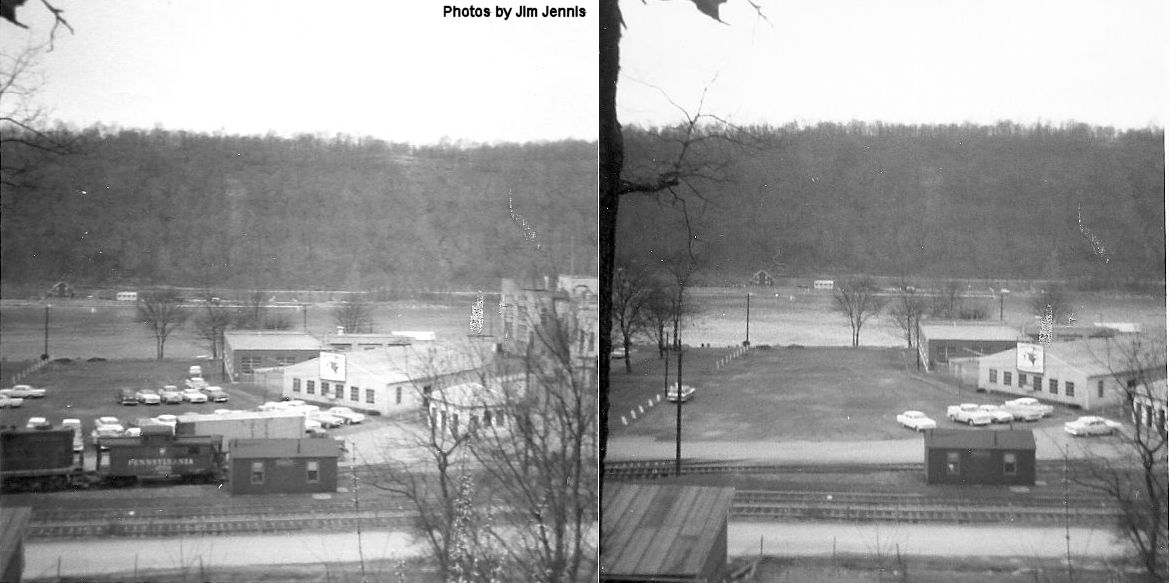
| Schenley |
|
This station was on Railroad Street at GPS: 40.684066, -79.662988 just in front of the main gate of the old Jos. R. Finch Distillery. The station was made of wood and insulbrick. | ||||||
| Schrecongost |
Rural Valley RR |
|||||||
| Seminole |
|
This was on the Oakland Branch. | ||||||
| Summit (Harkleroad) |
Rural Valley RR |
|||||||
| Templeton |
|
The first station here was a boxcar body with a station sign. Years later, when townspeople complained to the RR that the station was too small and run down, the railroad brought in another boxcar in the middle of the night and attached it to the older one thus doubling the depot capacity (New Castle Herald, 11-08-1909). | ||||||
| Templeton |
|
|||||||
| Thayerton |
|
|||||||
| Tidal junction |
|
|||||||
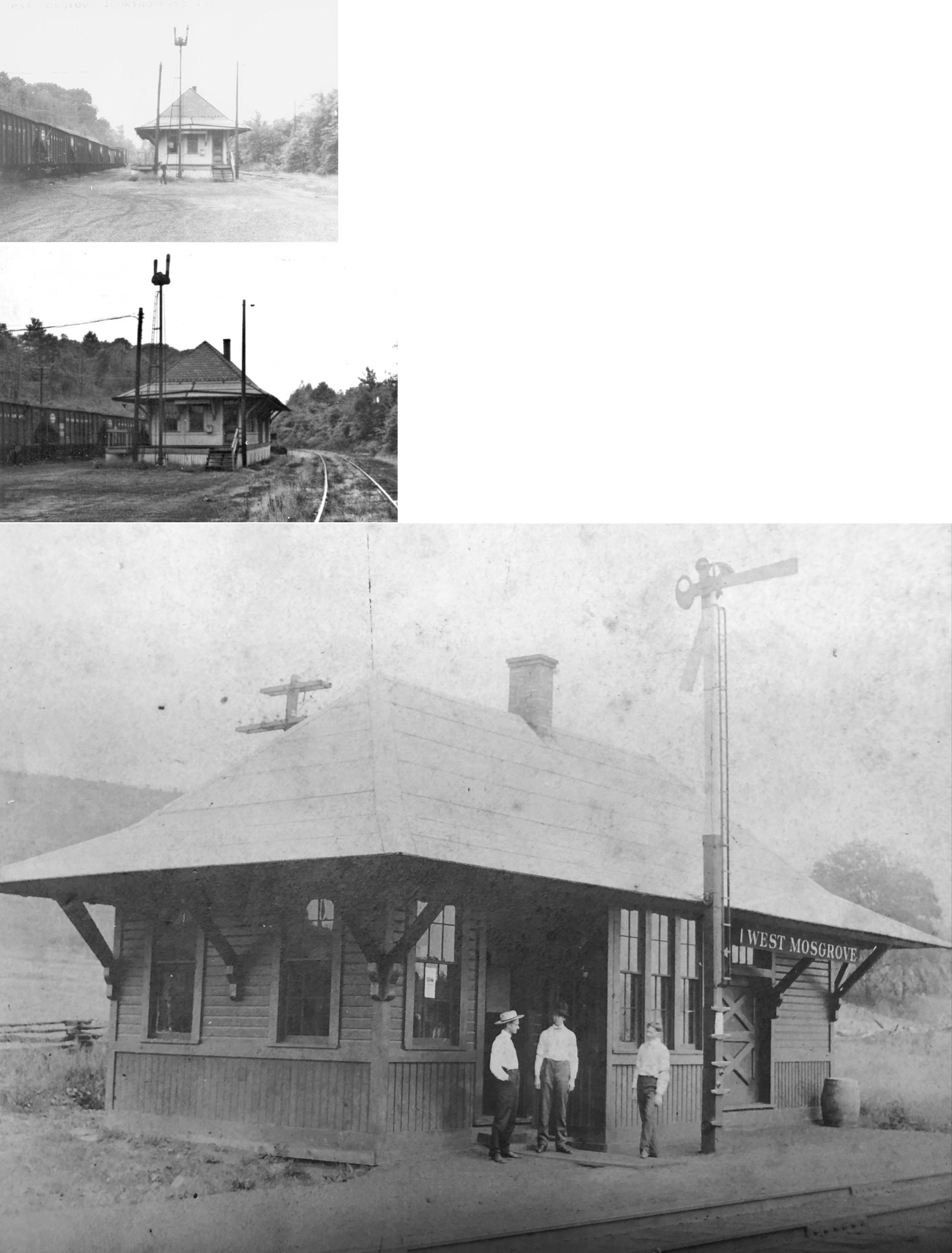
| West Mosgrove |
AND |
This station burned down around 1979-1980. | ||||||
| West Templeton |
|
|||||||
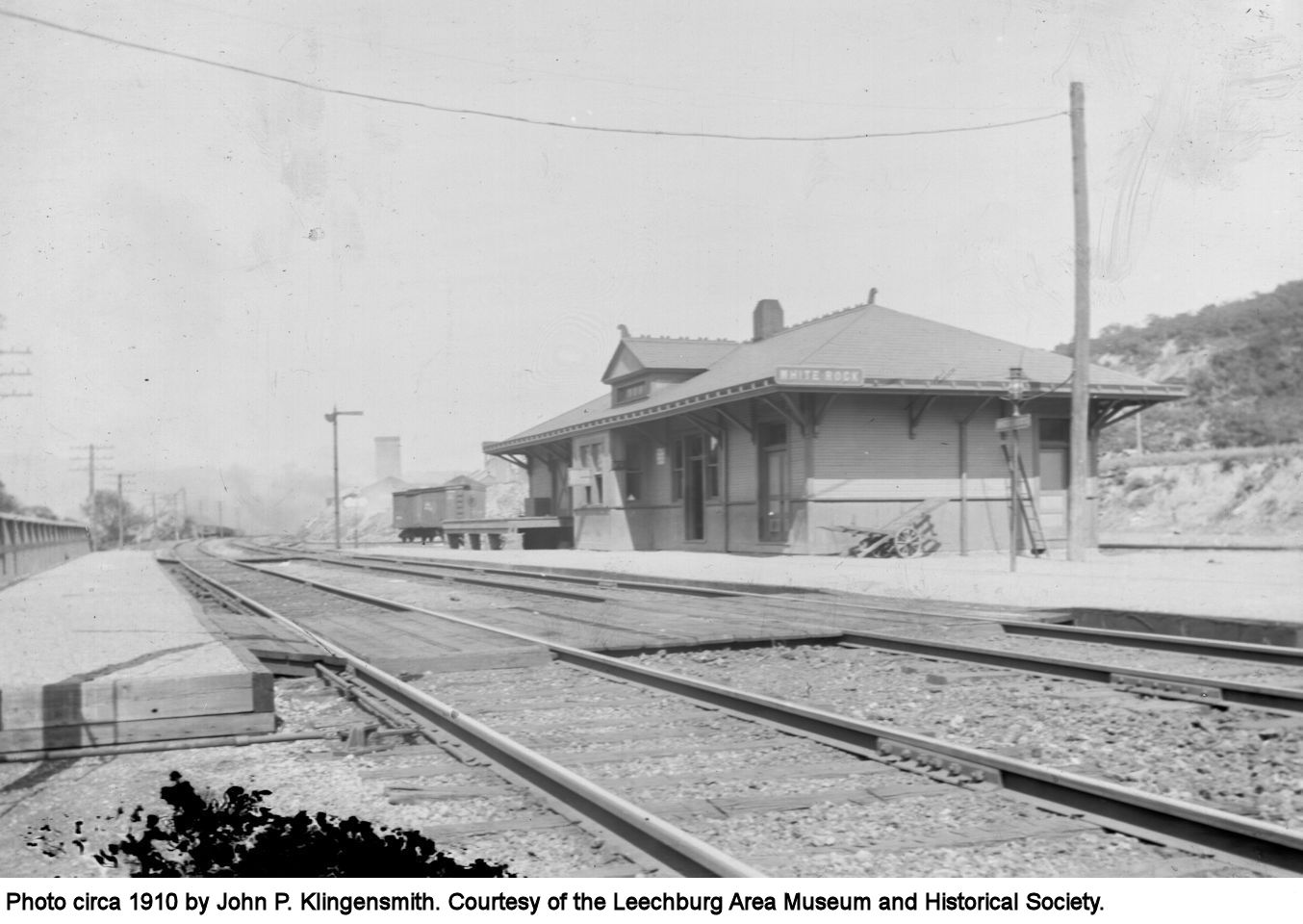
| White Rock (Johnetta) |
|
This station was between Kelly's Station and Donely's Station near the White Rock ferry. It is shown on the 1876 county map. This station is shown on the 1923 PRR List of Stations & Sidings. It was previously known as White Rock and White Rock Eddy with the name being changed to Johnetta in 1912. | ||||||
| Worthington |
|
|||||||
| Yatesboro |
|
This station was on the Rural Valley Branch. The Rural Valley RR operated from here from 1900-1925 from Echo to Yatesboro. | ||||||
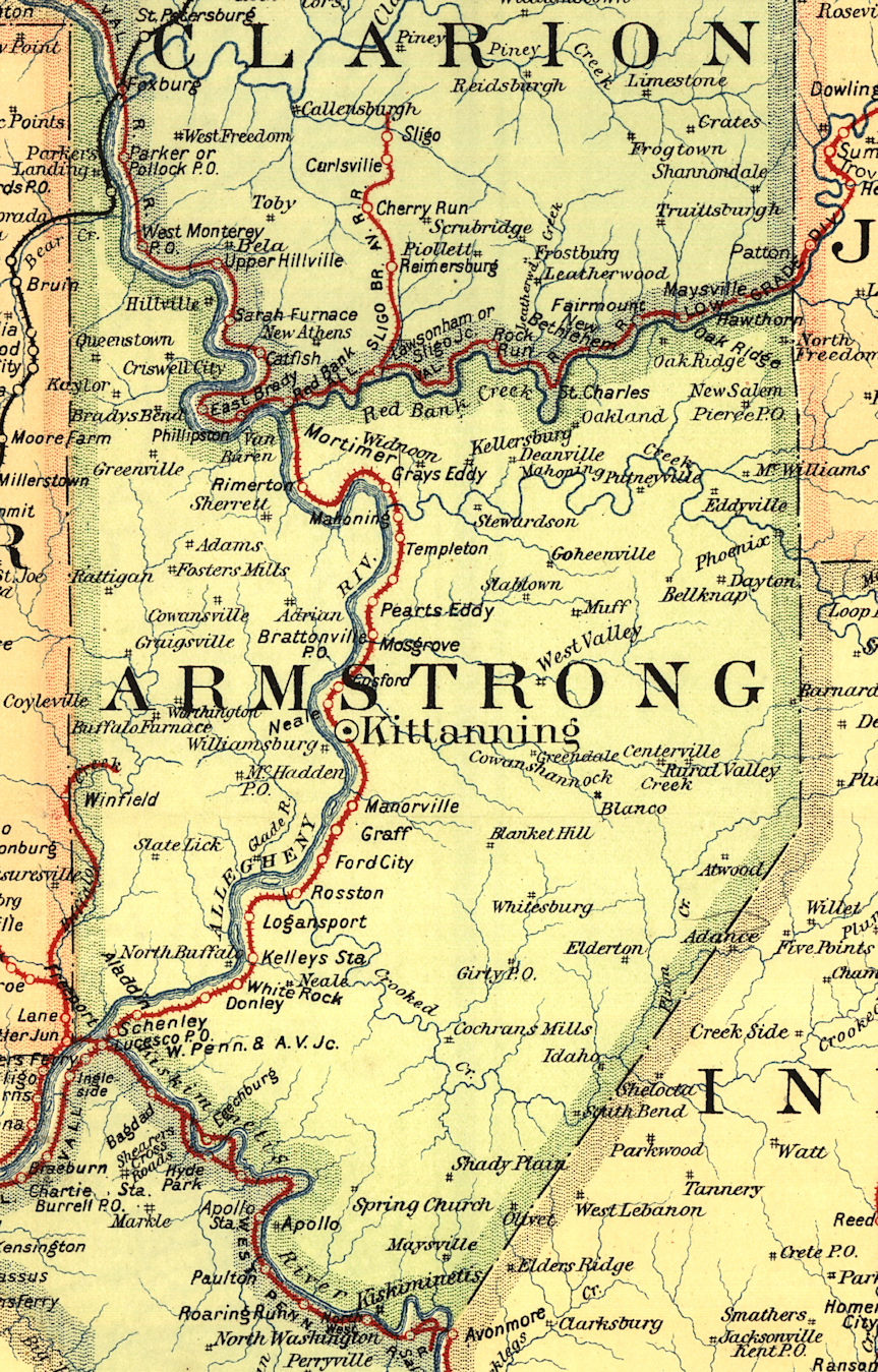
| 1895 ARMSTRONG COUNTY RAILROAD MAP | ||||||||
 |
||||||||
| Notes About Existing
Stations... Leechburg (Western Penn RR) - This station only served passengers from 1887 until 1904. Service was first interrupted when the Hyde Park Railroad bridge was destroyed in the Johnstown Flood of 1889. The bridge was rebuilt and then destroyed again in 1904 by an ice jam. A new station was then built, thus cutting off the town and this original 1887 station. Schenley (Kiski Junction RR) - Built on the site of the old PRR station. The Kiski Junction Railroad was abandoned in 2021. The track was still in place as of then, but there are plans to turn the right of way into a trail. As of 2022 the rails were being removed. |
||||||||