 COUNTY COUNTY
|
|
||||||||
| EXISTING STATIONS | ||||||||
|---|---|---|---|---|---|---|---|---|
| Station Name |
Original Railroad | Current Location |
Type | Current Use |
Date Built |
Track Status |
Building Material |
More Info |
| Cincinnati |
 |
1301 Western Avenue (GPS: 39.109965, -84.537513) |
P | Museum | 1929 | In Use | Limestone |
|
| Cincinnati |
 |
2787 Spring Grove Avenue (GPS: 39.131995, -84.537532) |
F | Business | ???? | Gone | Brick |
|
| Cincinnati |
 |
2815 Spring Grove Avenue (GPS: 39.133131, -84.537851) |
F | Vacant | ???? | Gone | Brick | |
| Cincinnati |
|
664-700 West Pete Rose Way (Formerly 2nd Street) between I-75 (formerly the location of Smith Street) and Gest Street (formerly Mills Street). (GPS: 39.095740, -84.522879) | F | Business | 1904 | Gone | Brick |
|
| Cincinnati |
 |
2801 Spring Grove Avenue (GPS: 39.132556, -84.537681) |
F | Business | ???? | Gone | Brick |
|
| Elmwood Place |
|
15 East 66th Street (GPS: 39.189337, -84.484503) |
C | Business | ???? | None | Wood |
|
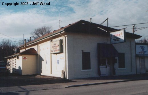
| Glendale |
 |
Greenville Avenue at Village Square (GPS: 39.271147, -84.459191) |
C | Museum | 1880 | In Use | Brick |
|
| Madeira |
 |
7701 Railroad Avenue (GPS: 39.188155, -84.363068) |
P | Restaurant | 1871 | In Use | Wood | |
| Milford |
 |
SR 126 at US 50 (GPS: 39.171840, -84.299659) |
P | Civic | 1844 | Gone | Wood |
|
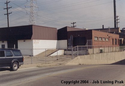
| Mount Washington |
 |
West side of Sutton Avenue at corner of Benneville Street (GPS: 39.087995, -84.390308) |
C | Civic | 1902 | Gone | Brick |
|
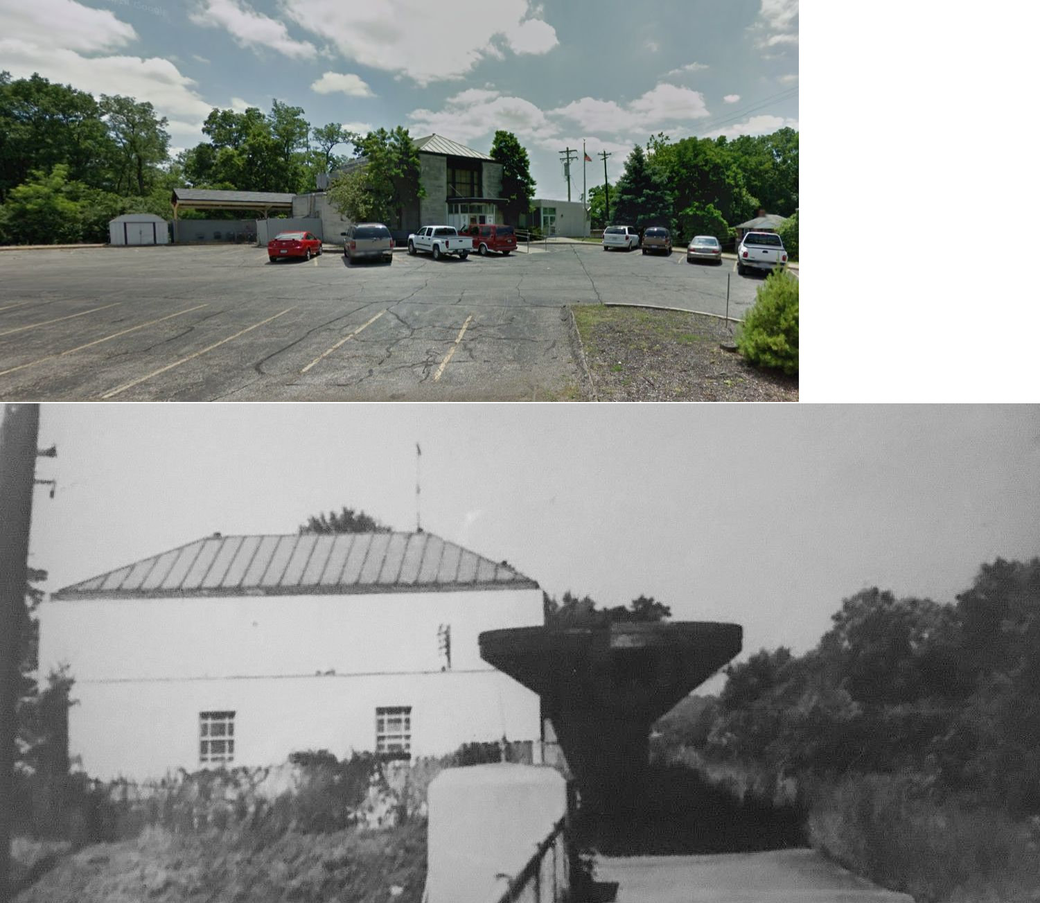
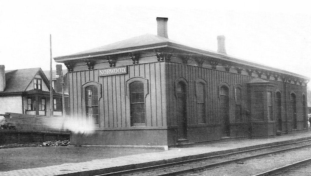
| Norwood |
 |
Forest & Harris Avenues (GPS: 39.162308, -84.446376) |
F | Railroad | 1960 | In Use | Brick | |
| Norwood |
 |
2863 Harris Place (GPS: 39.162554, -84.437677) |
P | Society | 1933 | In Use | Brick | |
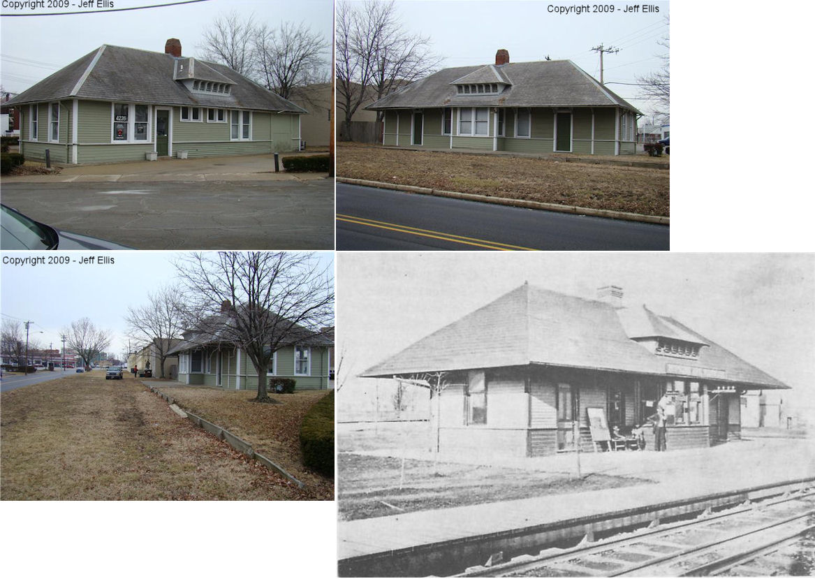
|
Norwood (Hopkins Ave.) |
 |
4226 Montgomery Road (At the intersection of Ashland Avenue, Lafayette
Avenue, and Montgomery Road) (GPS: 39.155444, -84.459419) |
P | Business | 1888 | Gone | Wood |
|
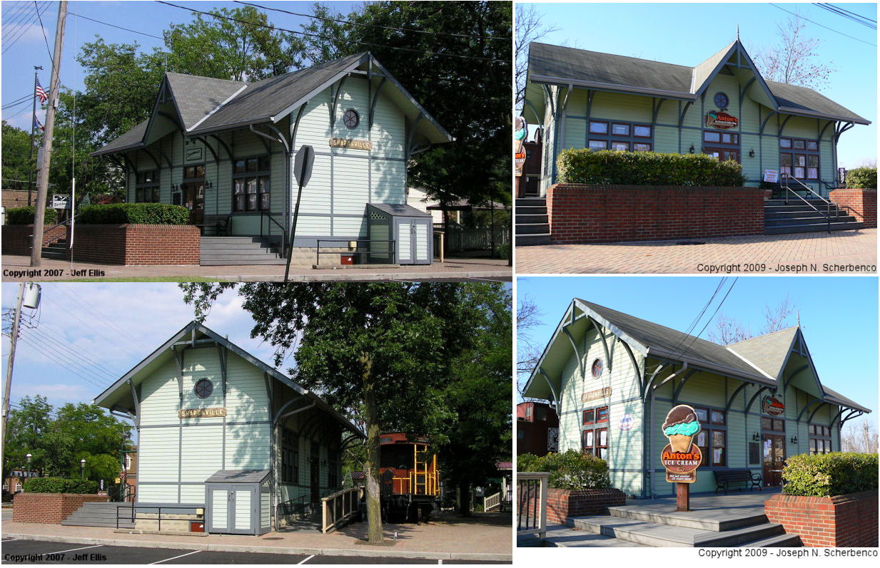
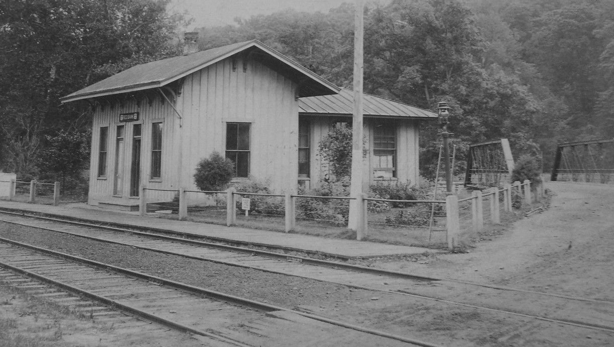
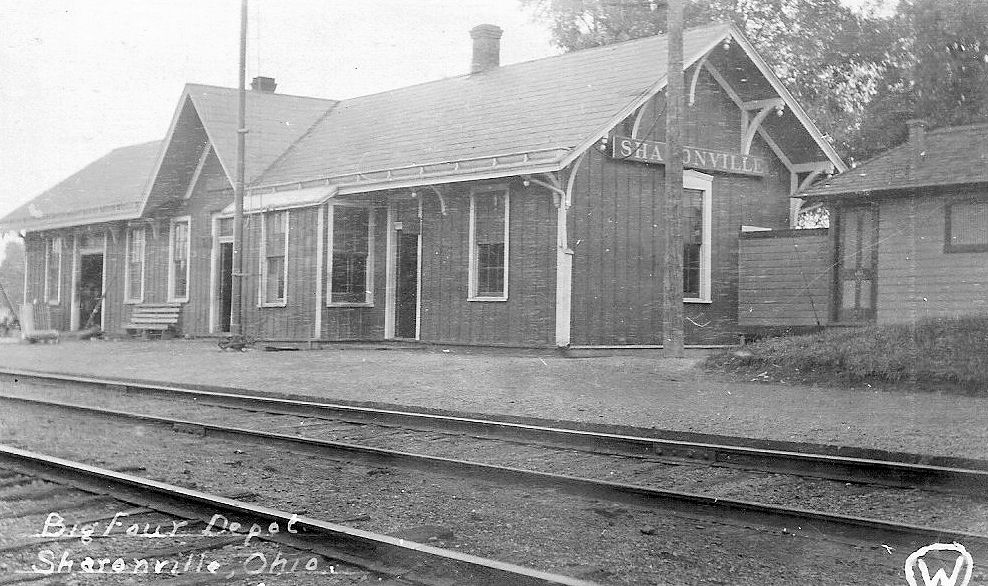
| Sharonville |
 |
3327 Creek Road, Depot Square (GPS: 39.270176, -84.413437) |
P | Business | ???? | None | Wood | |
| Silverton |
|
Montgomery Avenue between Highland Avenue and Parkview Lane. (GPS: 39.192183, -84.403510) |
P | Civic | 1976 | In Use | Wood |
|
| South Hartwell |
|
8231 Monon Avenue (GPS: 39.210555, -84.470095) |
C | Business | ???? | None | Wood |
|
| Winton Place |
|
Heritage Village Museum
in Sharon Woods (GPS: 39.279092, -84.399722) |
P | Museum | 1865 | None | Wood |
|
| Woodlawn |
|
272 Marion Road (GPS: 39.252029,-84.466559) |
C | Residence (Vacant) |
???? | None | Wood |
|
| STATIONS OF THE PAST | ||||||||
| Station Name |
Original Railroad |
Notes | ||||||
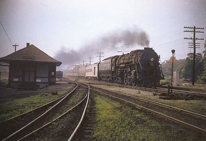
| Addyston |
|
Although some believe the Cleves station
was the same as the Addyston station, the two towns had separate
stations (as did North Bend) at one time. According to the 1938 Sanborn Fire Map of
Addyston, the depot was located on the east side of what was called
Depot Road. This station was at the southwest corner of the former U.S.
Pipe & Foundry Company. I believe this location is now well within the
confines of the Bayer Polymers Division complex. North Bend was a small settlement before Ohio statehood (1803), and included a strip of land upstream to Muddy Creek (now the Cinci Corporation Limit). The village was incorporated in 1845. Much of the land was owned by the Short family. When the ICL sought a right-of-way through, Short asked for, and got, a station stop (known as Short’s Station). It was about 2/10th mile down from the Fernbank stop. The Short family sold a large block of land in 1887 to Mathew Addy, who built a massive cast iron pipe plant (water and sewer). It would employ at peak around 1000 workers. Addy arranged with North Bend village officials to separate his property plus more down to around Indian Creek from North Bend jurisdiction and the new village of Addyston came Into being in 1891. When this happened Short’s Station disappeared and Addyston Station replaced it a tenth or so of a mile further down. The Addyston station was still there in 1953 with a Railway Express office still operating. --Note by Joseph Kyle |
||||||
| Allendale |
|
|||||||
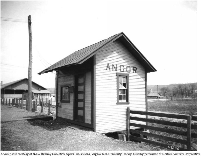
| Ancor |
 |
According to N&W valuation records, it was built in 1906. | ||||||
| Anderson's Ferry |
 |
On the Ohio River, about five miles downriver from the city center. The Ohio & Mississippi RR (later B&OSW, then the B&O) laid track through here in the early 1850s and built a small station that likely wasn't here very long. | ||||||
| Anderson's Ferry |
|
In the 1860s, the Indianapolis, Cincinnati & Lafayette RR (later part of the CCC&StL aka the Big Four, later NYC) laid track parallel to the O&M from Cincinnati thru Anderson Ferry as far as Cleves, OH and operated a station at the Ferry. From 1900-1930, the Cincinnati, Lawrenceburg & Aurora Electric Street Railroad maintained their Cincinnati terminus at this point. In 1900 Anderson Ferry Rd. was the city corporation line. Several efforts to acquire trackage rights into the city center by the CLA failed. When this inter urban line failed, the Cincinnati Street Railway Co. (CSR) acquired the track from Anderson Ferry to Fernbank at Muddy Creek, as the intervening villages of Delhi, Home City (Sayler Park) & Fernbank were now part of the city. The CSR provided horse car service to the Ferry until 1895, then switched to electric streetcar service. CLA patrons had to transfer at the Ferry to reach the heart of the city. Until the automobile age, the Big Four maintained commuter service at multiple stops along this line. When the Central Union Terminal closed on 1933 and moved to the new Union Central facility, its inconvenient location killed what was left of the commuter traffic and Big Four “accommodation” service ended. B&O commuter service had always been limited, and focused primarily on patrons outside the city limits including Indiana residents from Lawrenceburg, Aurora, and even Osgood, IN. All three facilities at the Ferry were gone by the early 1930s. --Joseph Kyle | ||||||
| Arden |
|
This
station stop was along Lower River Road, US-50 (Gracely Drive) at Laura
Lane in Home City (Sayler Park). There seems to have been only an open
sided weather shelter and station sign at this site. The stop
originated at the behest of Nelson Sayler, prominent attorney and civic
leader, whose imposing mansion and grounds called "The Forest of Arden"
were located here. The village of Home City, renamed Sayler Park in honor
of Mr. Sayler, was annexed into the City of Cincinnati in 1911. |
||||||
| Arlington Heights |
|
|||||||
| Avondale |
|
|||||||
| Blue Ash |
|
This station was torn down in 1935. | ||||||
| Bond Hill |
|
|||||||
| Brecon |
|
|||||||
| Brighton |
 |
The C&W was a short, narrow-gauge steam line that began in 1874 primarily to serve Westwood from its connection with the CH&D at Brighton. It converted to standard gauge in 1891, ended service in 1924, and was mostly torn up by 1941. | ||||||
| California |
|
|||||||
| Camp dennison |
 |
This station was on the north side of Lincoln Avenue at Clement Street. The station was on the west side of the tracks. | ||||||
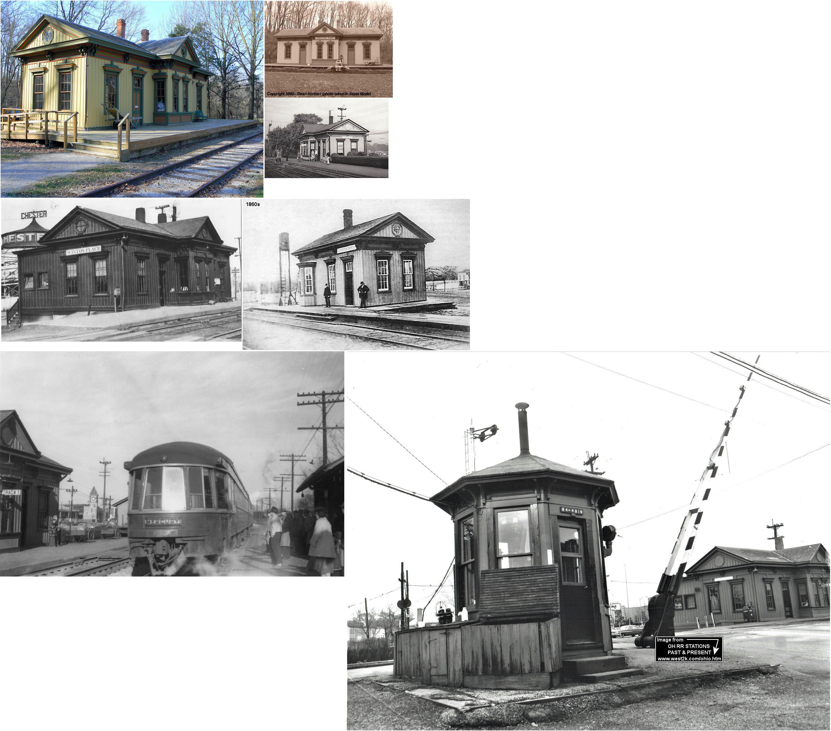
| Carthage |
|
This station was on the eastern corner of Lebanon and 5th Street. I believe this location is now Lebanon and East 66th Street. The station was on the SE side of the tracks. | ||||||
| Carthage |
|
|||||||
| Cedar Point |
|
Thsi station was between California and Forestville on the CG&P. | ||||||
| Chevoit |
|
This station was between Westwood and Glenmore. | ||||||
| Cincinnati |
 |
This station was built in 1971 and was located at 1901 River Road (U.S. 50). It was the first station built by Amtrak and served Amtrak until 1991. The station was demolished in February 2010 to make way for a highway improvement project. | ||||||
| Cincinnati |
 |
This Cincinnati, New Orleans & Texas Pacific freight station sat at Front and Vine Streets. The old passenger station for this RR was across the river in Ludlow, KY. There was also another CNO&TP freight station on the south side of Front Street (now Mehring Way) between Baymiller and Mills Street (now Gest Street). There is now a coal barge loading facility on that site. Another CNO&TP freight house was on the north side of West 2nd Street at Park Street. This freight station was next to the CW&B freight station (they were back to back with the CNO&TP station on the west side of this block and the CW&B on the east side. | ||||||
| Cincinnati |
 |
This Chicago, Cincinnati & Louisville RR (The "Straight Line") combination station was on McLean Avenue near 8th Street. It was built in 1903. This line became part of the C&O in 1910 and passenger service was transferred to the main C&O station on 4th Street. | ||||||
| Cincinnati (Court Street) |
|
The first station here was on the SE corner of Court and Broadway Streets. It served until 1885 when the new station (listed below) opened. | ||||||
| Cincinnati (Court Street) |
|
This passenger terminal opened in December, 1885 on the north side of Court Street between Broadway and Gilbert Streets. The station also served the Ohio & Northwestern RR (Cincinnati to Gallipolis line, later part of the N&W) so it had a mix of standard and narrow gague rails approaching it. The CL&N later became part of the Pennsylvania Railroad. The station closed in March, 1933. | ||||||
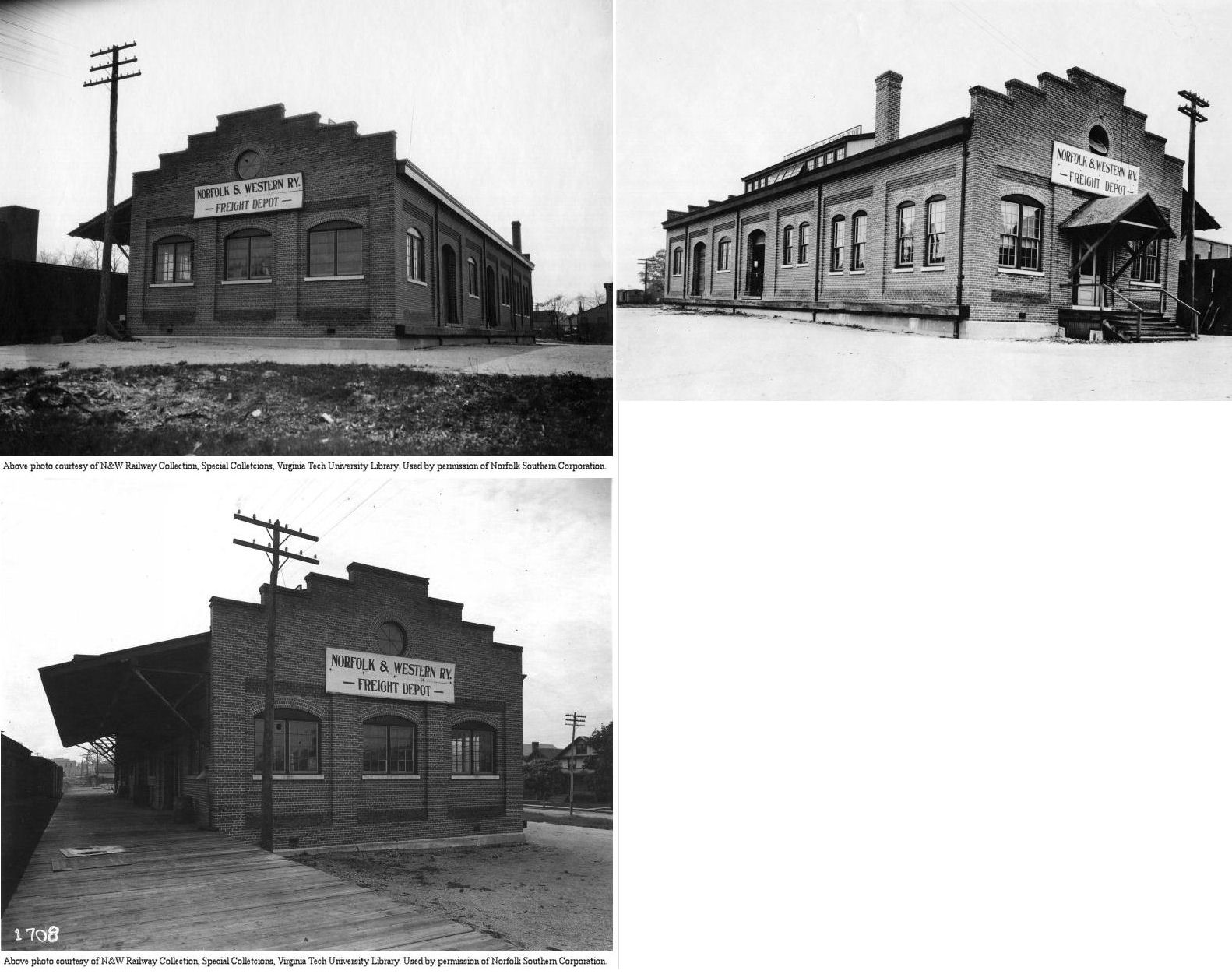
| Cincinnati |
|
This freight station was built in 1885 along with the passenger station and replaced in 1925 (see PRR Court Street freight station below). It was used by Cincinnati and Eastern, Ohio and Northwestern, Cincinnati, Portsmouth & Virginia, and Norfolk & Western. | ||||||
| Cincinnati (Oak Street) |
|
|||||||
| Cincinnati |
 |
The first station here was a temproary depot on Court Street opened when the CN ran it's first train from here on Feb. 11, 1882. The new permanent depot at Court & Broadway Streets was completed later that year with the first train running on October 23. | ||||||
| Cincinnati |
|
The first CH&D station was located near 5th and Baymiller Streets. It was a combination passenger and freight frame structure that was built around 1846 not long after the RR was incorporated. It served as the passenger station until 1851 when the larger new station was built. After that the building was used as a freight station and yard office. | ||||||
| Cincinnati |
|
The second CH&D station was built in 1851 and was a large combination station. When traffic and congestion at the station become a nuisance, a new station was built next door (see below) and this station was relegated to freight-only use. | ||||||
| Cincinnati |
AND |
This was the third CH&D station. Was on northwest corner of West 5th & Baymiller Streets next to the 1846 and 1851 stations. It opened in 1864. Railroads that used this station were: Marietta & Cincinnati (M&C), Cincinnati, Indianapolis & Western (CI&W), Chicago, Indianapolis & Louisville (CI&L, a.k.a. Monon), and Atlantic & Great Western (A&GW). The M&C only used the station for a few years before moving in as a tennant in the Plum Street Station (see listing below for CCC&St.L Plum Street). The CH&D became part of the B&O in 1917. Station was closed in September 1932. | ||||||
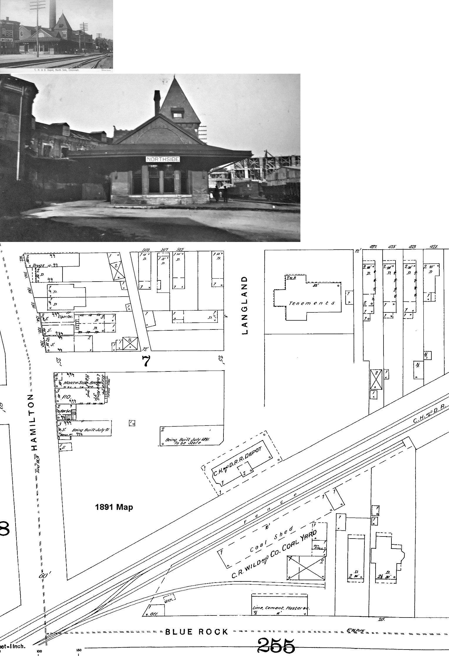
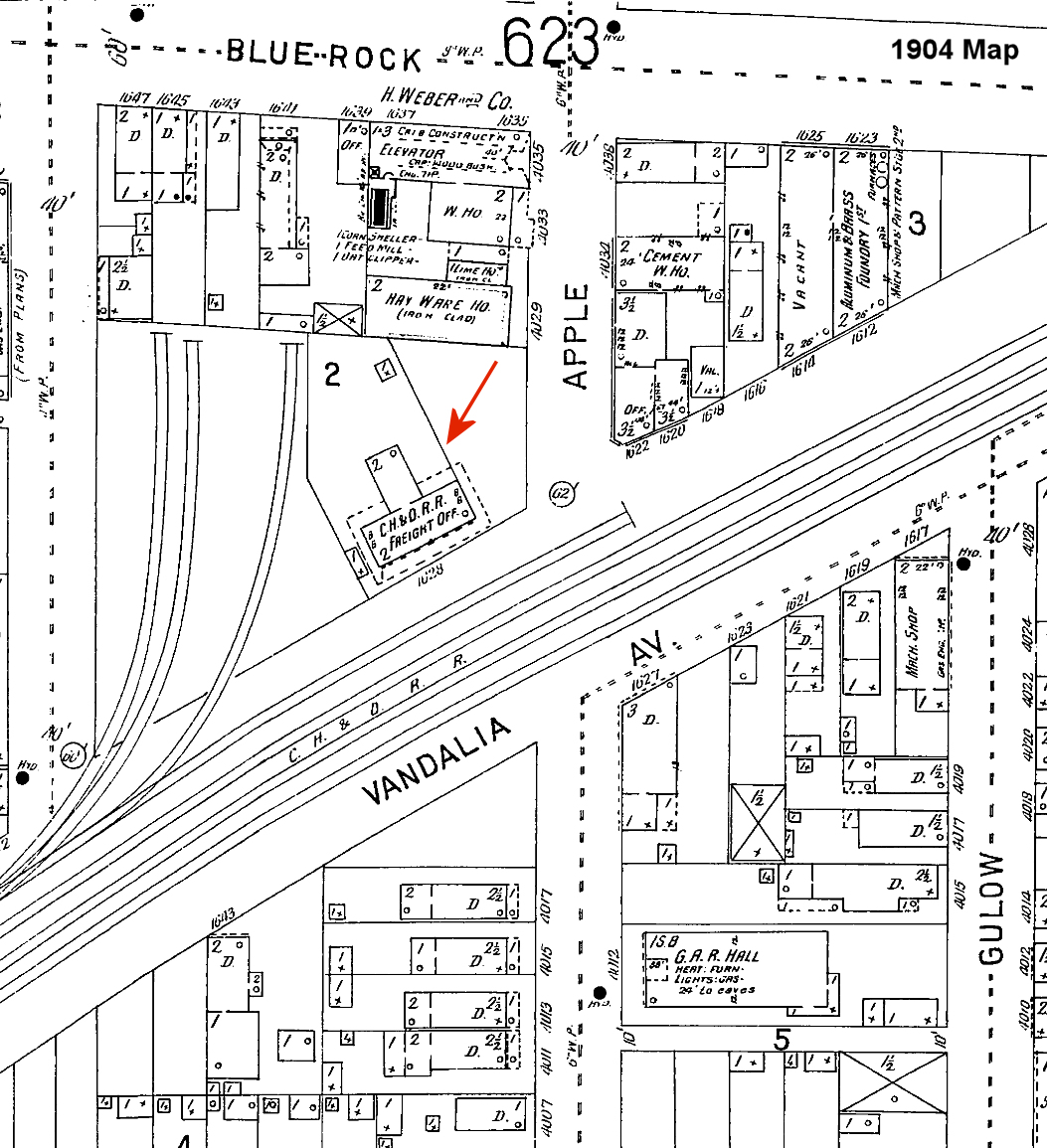
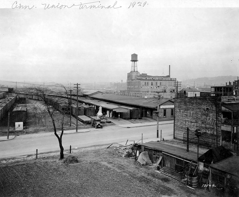
| Cincinnati (Northside) (Cumminsville) |
|
The CH&D Northside Station was opened in 1851. It was closed in 1966. It was on the north side of the tracks at the south end of Langland Street at GPS: 39.160638, -84.538436. | ||||||
| Cincinnati (Northside) |
|
There was a 2-story brick freight station on the NW corner of Apple Street and Vandalia Avenue at GPS: 39.159730, -84.541343. It is shown on the 1904 Sanborn, but was gone by 1934. | ||||||
| Cincinnati |
|
There was a large freight station at the corner of Sixth and Hoadley Streets that extended to Fifth Street. It burned down 1885. At the time the bottom floor was used as a freight depot while the second and thrid stories were occupied by the Cincinnati Malting & Warehouse Company (Springfield Globe-Republic, 9-04-1885). | ||||||
| Cincinnati (Gest Street) |
|
There was a freight station at the SE corner of Depot and Gest Streets. | ||||||
| Cincinnati (Brighton) |
|
There was a freight station here. This station was also used by the N&W (via a lease) to serve the west side of the city. | ||||||
|
Cincinnati (Cincinnati Jct.) (Cincinnati TFR.) |
|
Also known as Cincinnati Transfer Station. This Station was about one mile from the Central Union Station. CHD lacked direct access to that station. This facility served CHD patrons transferring to/from the B&OSW and the CNO&TP (Queen & Crescent Line). | ||||||
| Cincinnati (Fairmount) |
|
There was a passenger station on the north side of Harrison on the west bank of Mill Creek (near where the Western Hills Viaduct is today). A freight station sat on the south side of Harrison. | ||||||
| Cincinnati (Southside) (S. Cumminsville) |
|
Not to be confused with the Big Four station at Southside, this station was between Fairmount and Northside (Cumminsville). | ||||||
| Cincinnati (Dane Street) |
|
This passenger station was on the east side of Dane Street just south of Chase Avenue. It was on the north side of the tracks | ||||||
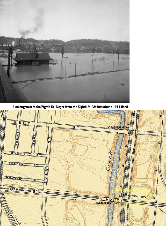
|
Cincinnati (Eighth Street) |
|
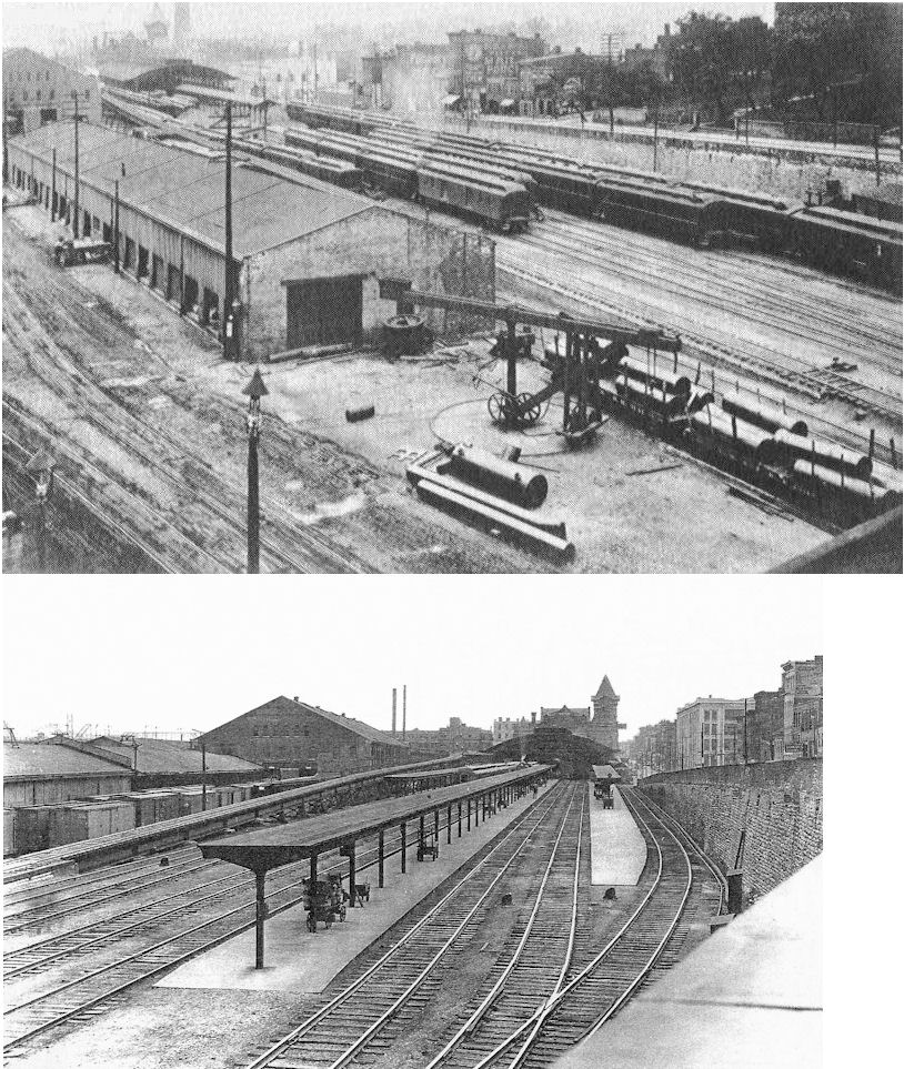
That station was under the 8th Street Viaduct on the west side of the tracks. See photo for specific location details. | ||||||
| Cincinnati |
|
The first Ohio & Mississippi RR station was on the south side of Front Street between Mill and Wood Streets and was built in 1854. It was a small wooden depot. | ||||||
| Cincinnati |
|
The second Ohio & Mississippi RR station was built in 1873 on the south side of Front Street between Mill and Wood Streets (on the same site as the 1854 station listed above). According to the 1887 map, there were five buildings at this site for the O&M: a outward bound freight house (with a 2-story head house), an "inward bound or receiving depot," an "express depot," and two more smaller freight houses on the east side of Mill Street. | ||||||
| Cincinnati |
|
The O&M had a freight house in the middle of the transfer yard off West 6th Street between German and Neave Streets. | ||||||
| Cincinnati |
 |
|||||||
| Cincinnati |
|
This station was located on the south side of 4th Street between Smith and John Streets. In 1891 the C&O converted an old row house that was originally built in 1869 into its station here. The station was also used by the Louisville & Nashville RR. It was closed in September, 1932. | ||||||
| Cincinnati |
|
There was a block-long C&O frieght house on the south side of West 3rd Street between Park and Rose Streets. | ||||||
| Cincinnati (Plum Street) |
|
Located at Plum & West Pearl Streets, this station was opened in December, 1865 when the Indianapolis, Cincinnati & Lafayette RR (later part of the CCC&I and then CCC&St.L) coverted the Pearl Street Market House into its station. It then become known as the Plum Street Station and was regarded as Cincinnati's first union station. In 1883 when the "new" Union Terminal was built, this station became a freight warehouse for the Big 4. In 1887, Sanborn Fire maps show the station as "in ruins," but on the 1891 map it shows the station as "being built." It appears that the original headhouse on the east remained occupied by the Pullman Palace Car Company, but most of the structure westward was rebuilt when that part became a freight facility for the CCC&St.L. It was damaged in a fire in 1944, repaired, and finally demolished in 1961 to make way for the Mill Creek Expressway. In the early days, the station was also used by the Marietta & Cincinnati RR. | ||||||
| Cincinnati |
|
There was a freight house on the SW corner of West 6th and Evans Streets. There was a 16-stall B&O roundhouse just to the SE of that station. | ||||||
| Cincinnati |
|
There was a freight house on the block bordered by Central Avenue, West 2nd Street, Smith Street and West 3rd Street (GPS: GPS: 39.097002, -84.519704). It was built in 1889 and destroyed by fire on Sept. 30, 1899 (Cleveland Plain Dealer, 10-01-1899). A temporary structure was built while the RR quickly erected another permanent structure here. The temporary freight house was literally on the same site as the new freight house as construction crews used the roof of the temorary structure as a floor to build the new structure over it. | ||||||
| Cincinnati |
|
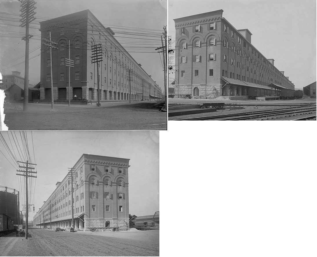
After the old freight house burned (see above listing), a new freight house was constructed here. It was 743' long and sat on the block bordered by Central Avenue, West 2nd Street, Smith Street and West 3rd Street (GPS: 39.097002, -84.519704). It opened on Nov. 30, 1900, after just two months of construction. The inbound platform was on the south side with the outbound platform on the north side. It was likely torn down to make way for the exressway and there is now a parking lot on this site (under the expressway). | ||||||
| Cincinnati (Deer Creek) |
|
The first station was a frame depot on the river bank east of Deer Creek. It was built around 1841 when the first section of the LM opened that year. | ||||||
|
Cincinnati (Pendleton) |
|
This station, built sometime between 1843-46, was prohibited from being built in the city limits because city council feared that the locomotives disturb horses. Thus, the depot was constructed three miles from the city center in what was then called Pendleton. Rail passengers in cars embarking from the Front Street depot were pulled by horses to the corporation line at Pendleton where the cars were then transferred to locomotives. Around 1848 the site was updated with new freight houses and a new passenger station. This station complex was active until 1859 when a new station was built at Front Street in Cincinnati. | ||||||
| Cincinnati |
|
The original Front Street (south side of Front Street, east of Butler Street) depot was built in the 1840s. Passengers boarded the railcars there, but they were pulled by horses to Pendleton. See listing above for the story. | ||||||
| Cincinnati |
|
With the restrctions against locomotives in the city lifted, the second Front Street depot was built in 1853 to handle both the engines and passenger cars. It became a freight only depot in 1881 when the PCC&St.L leased the Little Miami. It was also used by the L&N at that time. The station burned down in 1889. The L&N constructed its own freight house on this site after that. | ||||||
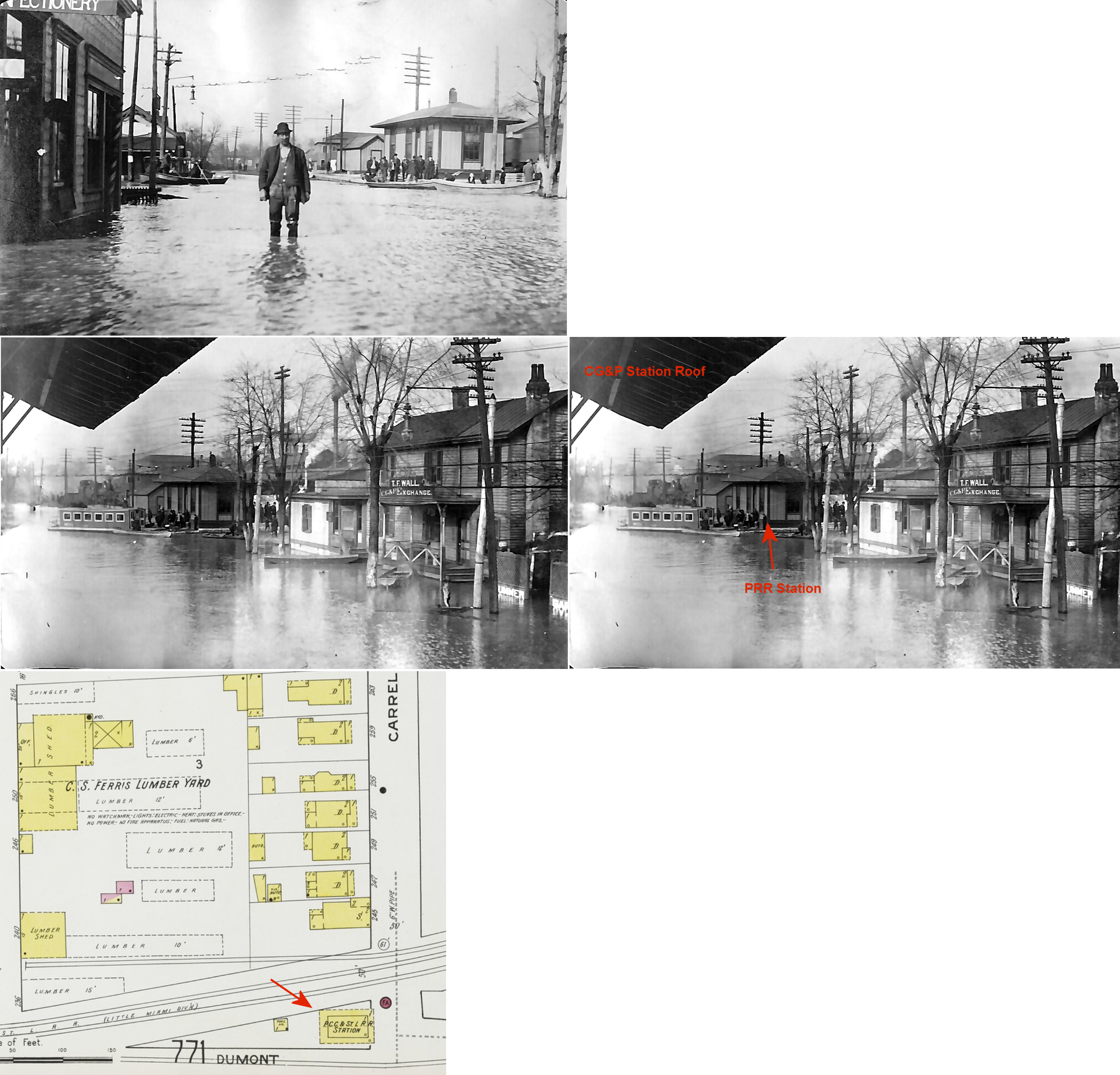
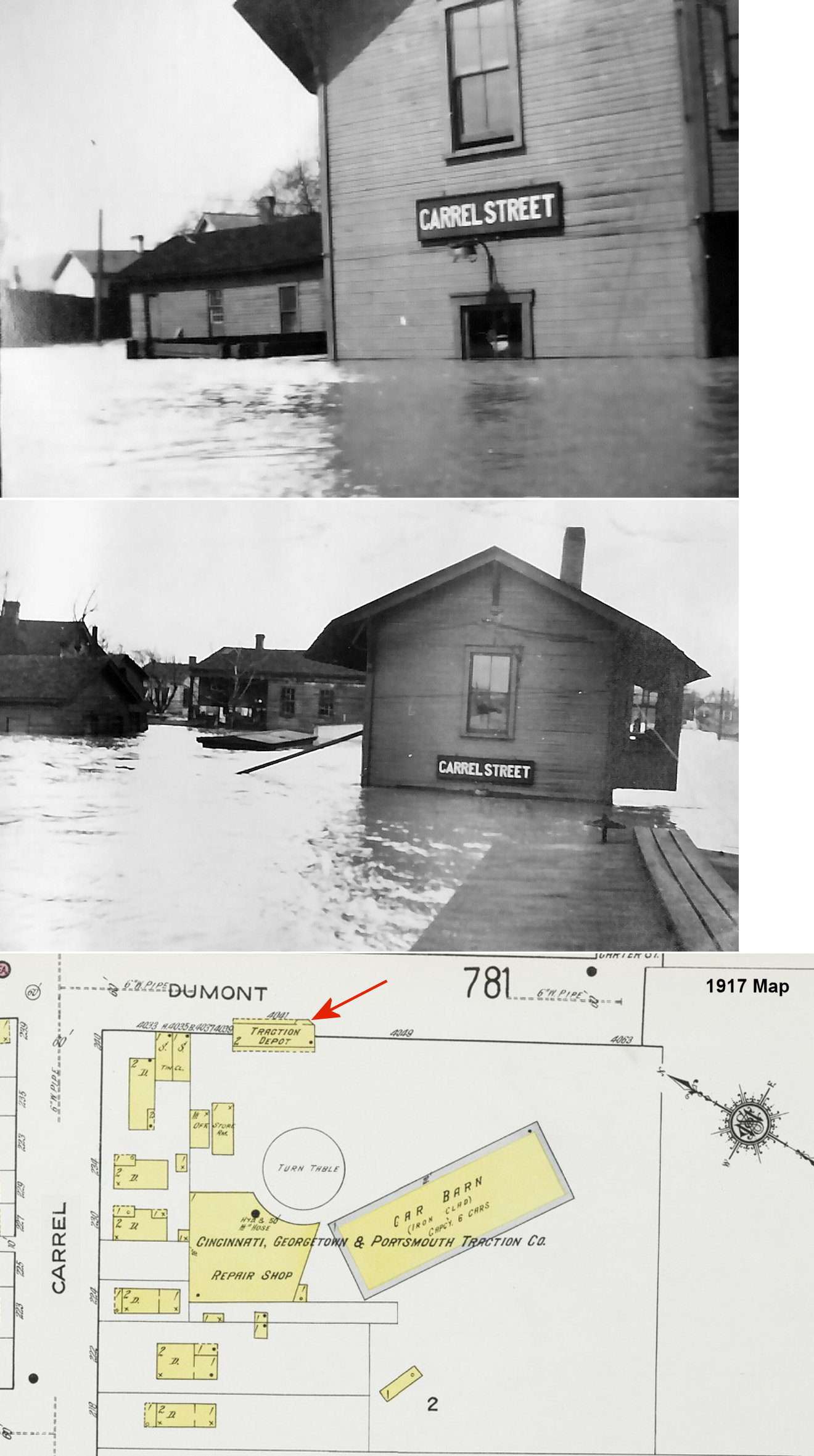
| Cincinnati |
|
The Carrel Street Little Miami (PRR) station was on the north corner of Dumont & Carrel Streets at GPS: 39.107869, -84.433996. The Carrel Street CG&P station was just to the south on the other side of the intersection. | ||||||
| Cincinnati |
|
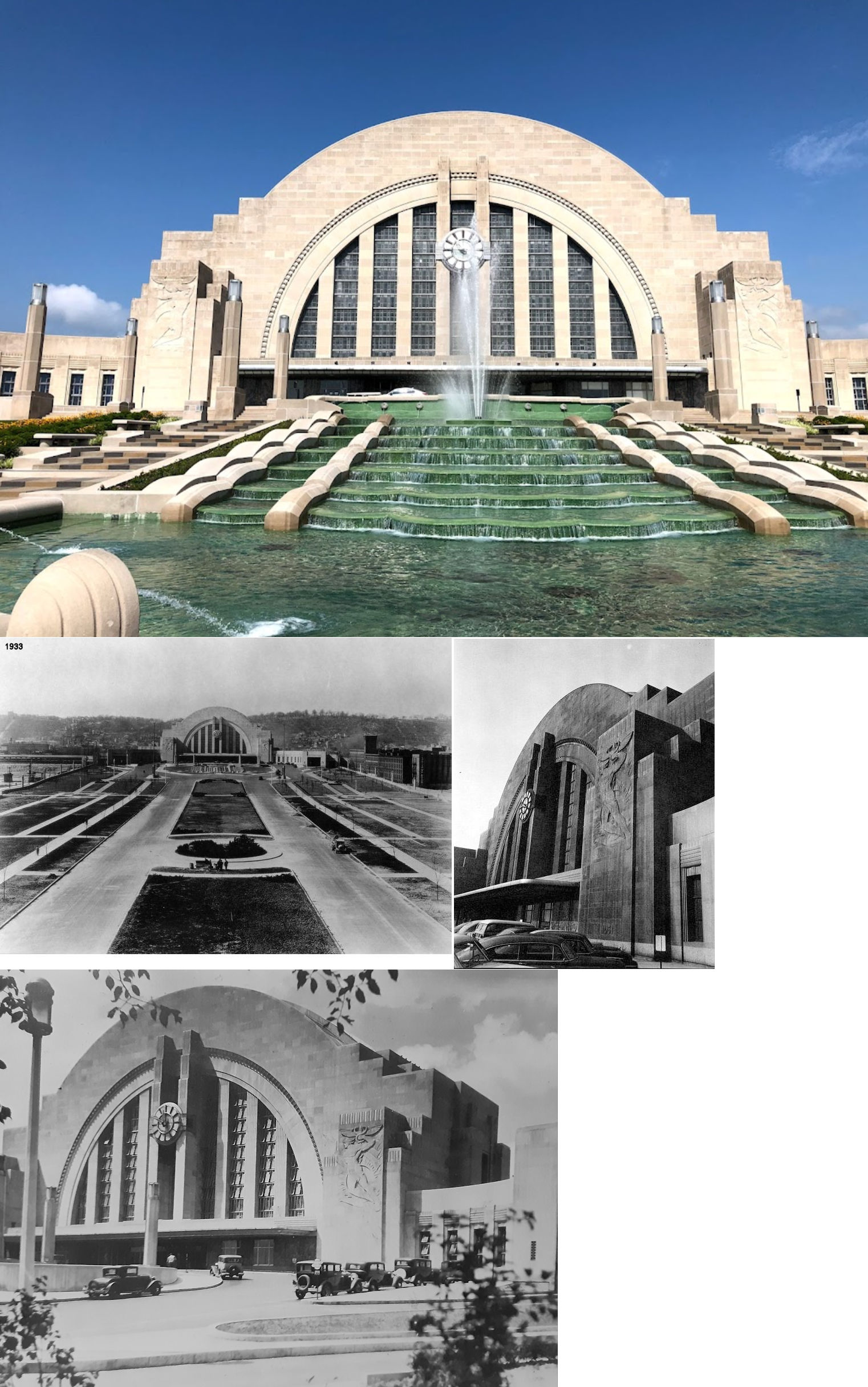
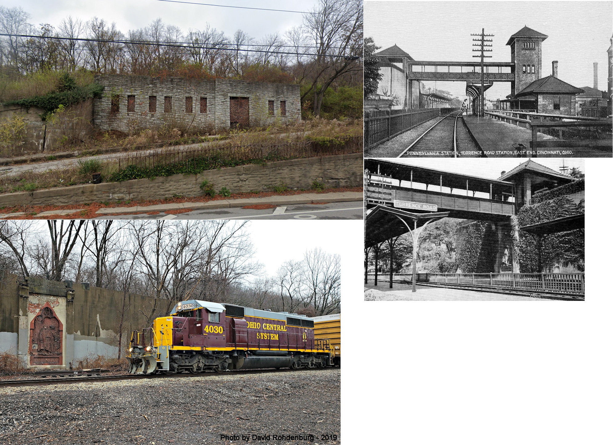
This was the Torrence Road station on the East side, built in 1907. The stone foundations of this station are existing; part of which has bricked up doors and windows in it. There are enough remnants to somewhat make out the use. There was an elevator there to carry passengers to a bridge across the tracks since it was built into a hillside. It is along Riverside Drive near the intersection with Lumber Street just to the NW of St. Rose Roman Catholic Church. The remnants are at GPS: 39.124372, -84.462001 where Torrence Road used to go up the hill. There are also some foundation remnants on the north side of the tracks. This depot was closed when the new union station opened in 1933. | ||||||
| Cincinnati |
|
A new passenger station was built by the PCC&St.L in 1881 to the northwest of the the old Front Street station which was converted into a freight house as part of a three-freight house complex to the east of the new passenger station. By this time Little Miami has become part of the PCC&St.L. Specifically, the passenger station in this complex was on the corner of Pearl (now Pete Rose Way) and Butler Streets. The Panhandle Station also served the L&N, N&W, C&MV and the Grand Rapids & Indiana RR. This station was in service until 1933 when the new Union Terminal opened. | ||||||
| Cincinnati |
|
This freighthouse was to the NE of the PCC&St.L passenger station (it is in the background of the photo). It was on the west side of Front Street. | ||||||
| Cincinnati |
|
There was a freight house on Smith Street near the corner of West 2nd and Rose Streets. These streets no longer intersect at that location which is under the I-75 overpass. This station was known as the Panhandle Smith Street Freight Station. It opened in June 1888. | ||||||
| Cincinnati |
|
There was a large PCC&St.L freight staion on East Front Street just to the NE of the end of Butler Street at approximately GPS: 39.100976, -84.499522. This former Little Miami RR station burned down at the end of December 1890 (Cincinnati Enquirer, 12-28-1890). | ||||||
| Cincinnati |
|
This is the Court Street freight house. It was built in 1925 and torn down in the late 1960s or early 1970s. A Greyhound bus station has occupied the site since. | ||||||
| Cincinnati |
 |
The L&N's freighthouse was on the southeast side of Front street, just to the northeast of the PCC&St.L freight station listed above. It was just east of the L&N bridge over the river. | ||||||
| Cincinnati |
 |
The NYP&O freight house was next to (north of) the PCC&St.L freighthouse on the west side of Front Street. | ||||||
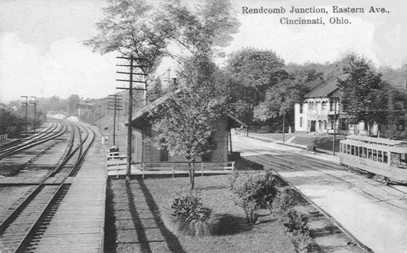
| Cincinnati (Rendcomb JCT.) |
|
This station was on the east side of Eastern Avenue about 400 feet north of Heekin Avenue. | ||||||
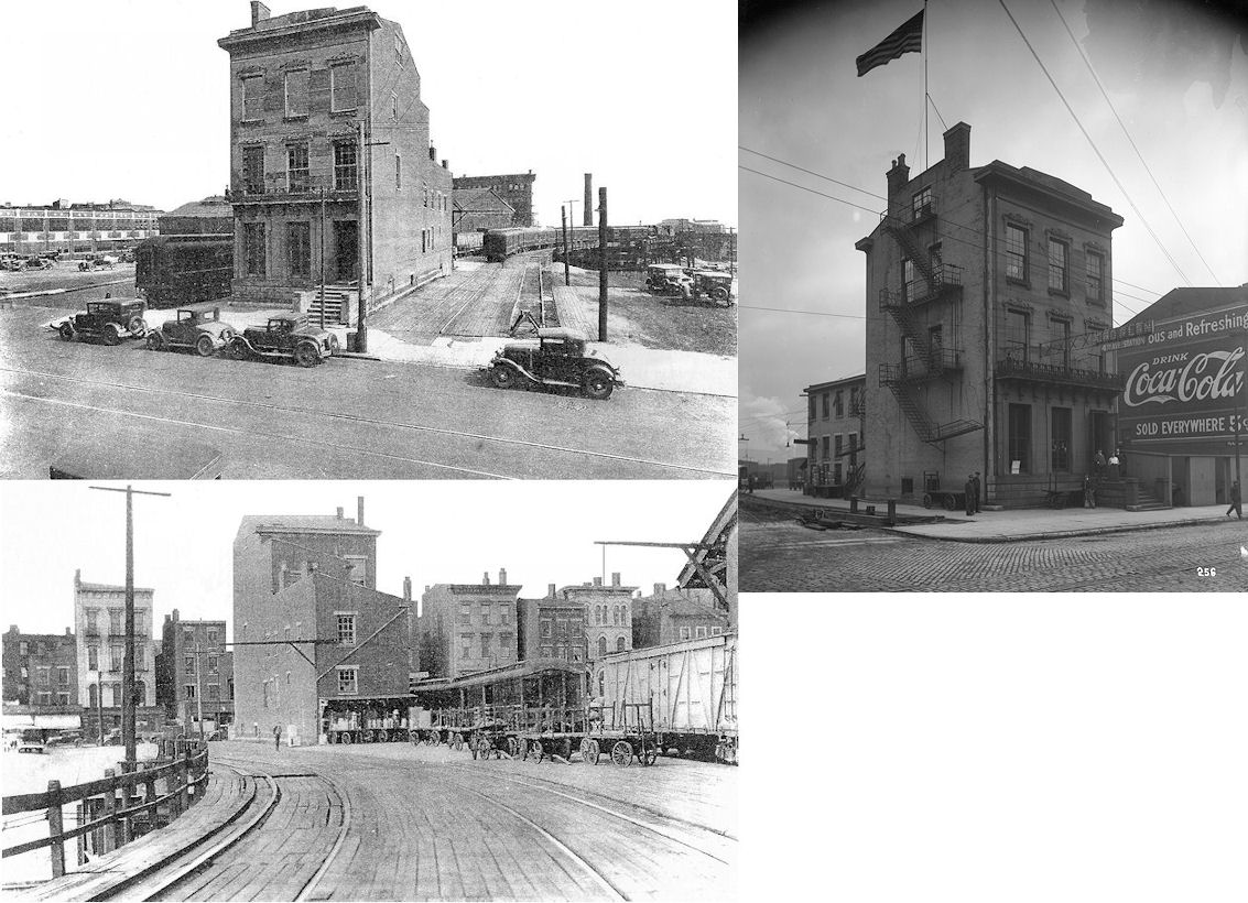
| Cincinnati |
|
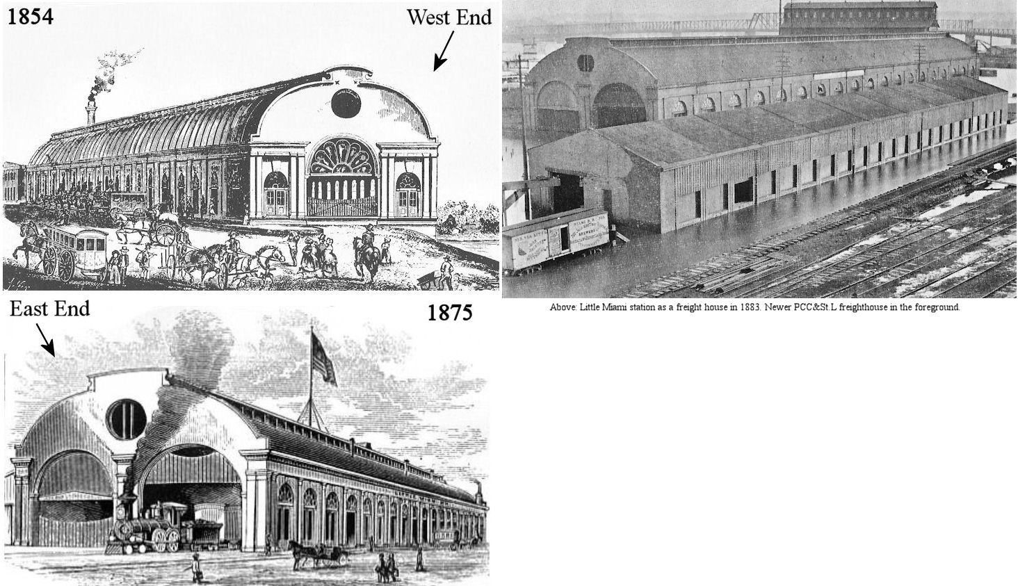
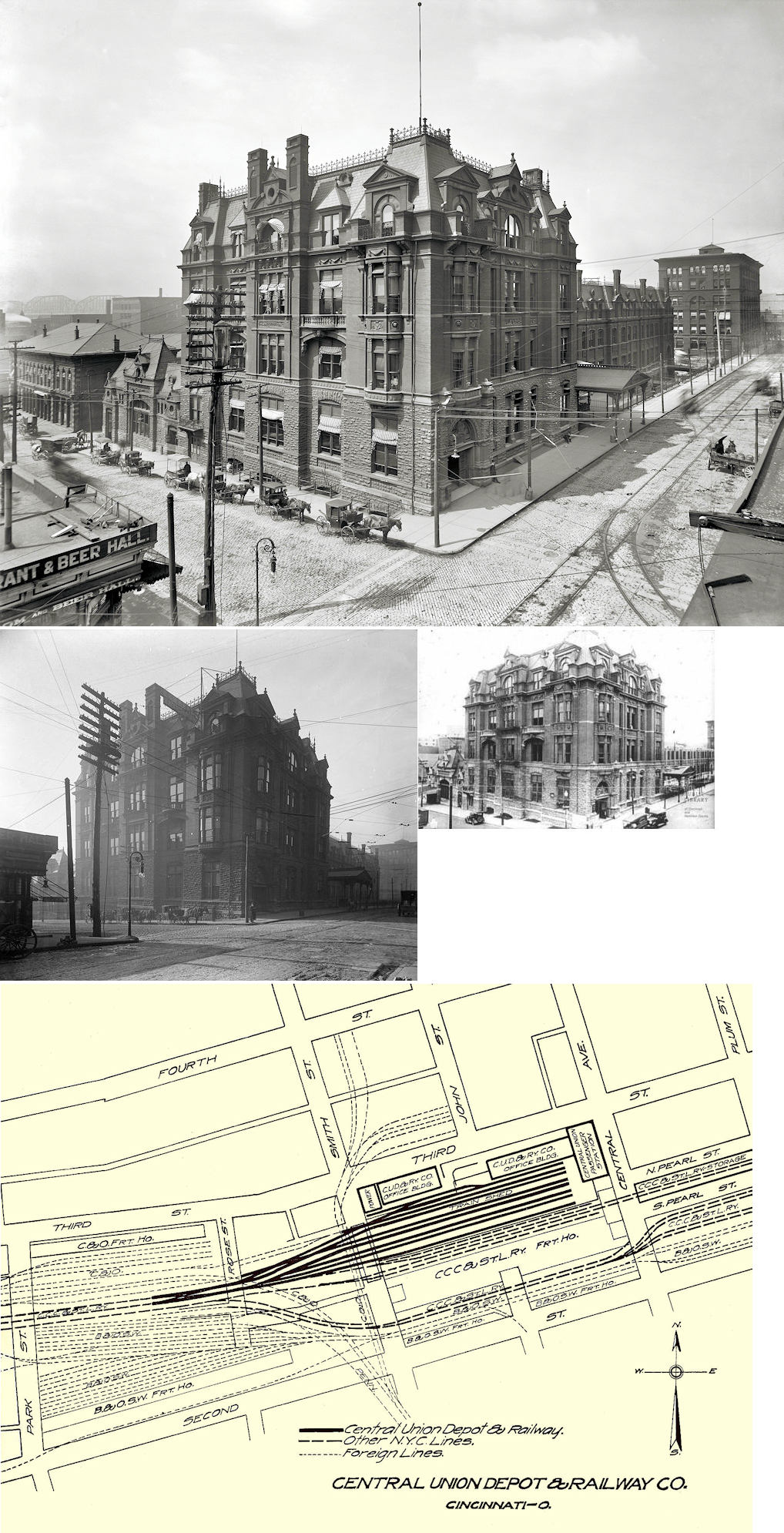
The old Central Union Terminal sat at the corner of Central Ave. and West 3rd Street (area is now a parking lot for Paul Brown Stadium). It was built in 1883 (opened on July 31, 1884) by the Cincinnati, Indianapolis, Saint Louis and Chicago Railroad (later part of the Big Four) and throughout its lifetime served the following railroads: CW&B (B&O), O&M (B&O), CCC&I (Big Four, NYC), C&O, Kentucky Central (L&N), Cincinnati Southern (CNO&TP, Southern), Cincinnati Northern, Illinois Central, Lake Erie & Western, and the Erie RR. It remained in service until March, 1933 when the new station opened. | ||||||
| Cincinnati |
 AND |
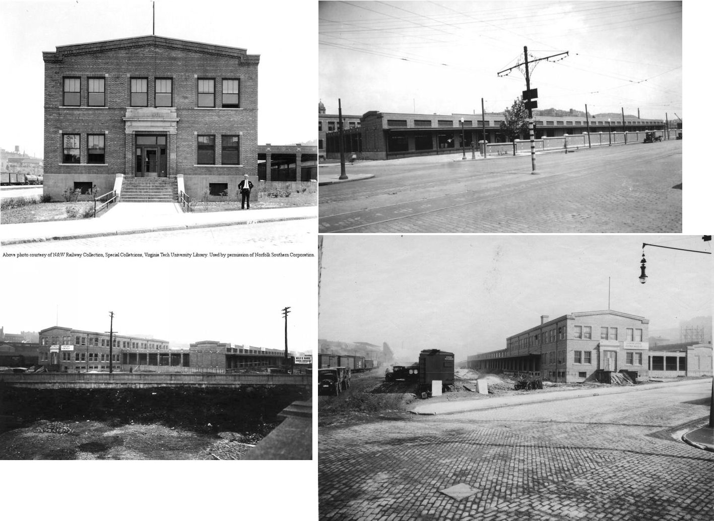
This freight house served the CW&B at Central Union Terminal and was just SW of the terminal on the north side of West 2nd between Smith and Mills Streets. Later the B&O built another freight house here directly across the tracks to the south of the CW&B freight house listed above. Both the old wooden freight station and the newer brick station can be seen in the photo. The brick station was built in 1904. | ||||||
| Cincinnati |
 |
A freight house served the CCC&I and CRR at Central Union Terminal. There was an inbound and outbound freight house connected by a headhouse/office. It was next to Central Union Terminal to the south with the headhouse at the corner of Central and South Pearl Streets. It extended along South Pearl one block west to Smith Street. It was originally built in 1863-64 to serve the Plum Street station and most likely saw additions in the run up to the building of Central Union Terminal. | ||||||
| Cincinnati |
|
In 1887 there was a CCC&I freight house on the north side of Front Street between Mill and Wood Streets (later renamed Baymiller St.) (across the street from the O&M stations at that time). | ||||||
| Cincinnati |
AND  AND  |
In 1887 there was a CCC&I/LE&W shared freight station on the south side of 3rd Street between Mill and Wood Streets (later renamed Baymiller St.). This was directly across the tracks from the station listed above. The 1891 map shows the east 1/3 of this building occupied by the CJ&M. This station burned down on August 21, 1894 (Cincinnati Enquirer, 8-22-1894). Another freight station was erected there soon after. | ||||||
| Cincinnati |
 |
The original passenger and freight house for this RR was on a fill on the west side of McLean Avenue between Hopkins and Kenner Streets (the current location of Cincinatti Union Terminal). In February 1883 both one-story stations were carried into the water when the fill gave way during a flood (The Perry County Democrat, 2-21-1883). | ||||||
| Cincinnati |
|
Later, there was a frieght house on Western Avenue northwest of McLean at GPS: 39.120277, -84.537219. | ||||||
| Cincinnati (union Stockyard) |
AND |
There was a station on the south side of Hopple Street west of Spring Grove Avenue (where the Hopple Street overpass is now). The station was on the east side of the tracks adjacent to the sheep sheds. The map from 1904 does not indicate which RR owned the station, so it may have been B&O, CCC&St.L or both. | ||||||
| Cincinnati |
|
The Carrel Street passenger station was on SE side of Dumont Street just south of Carrel Street at GPS: 39.107444, -84.433824. There was a CG&P turntable, roundhouse and repair shop near the station. The Little Miami (PRR) station was just across the intersection of Dumont & Carrel streets to the north. | ||||||
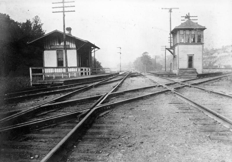
| Clare |
|
Clare was between Red Bank and Ancor and was the junction of the Hyde Park Branch. | ||||||
| Clare |
|
|||||||
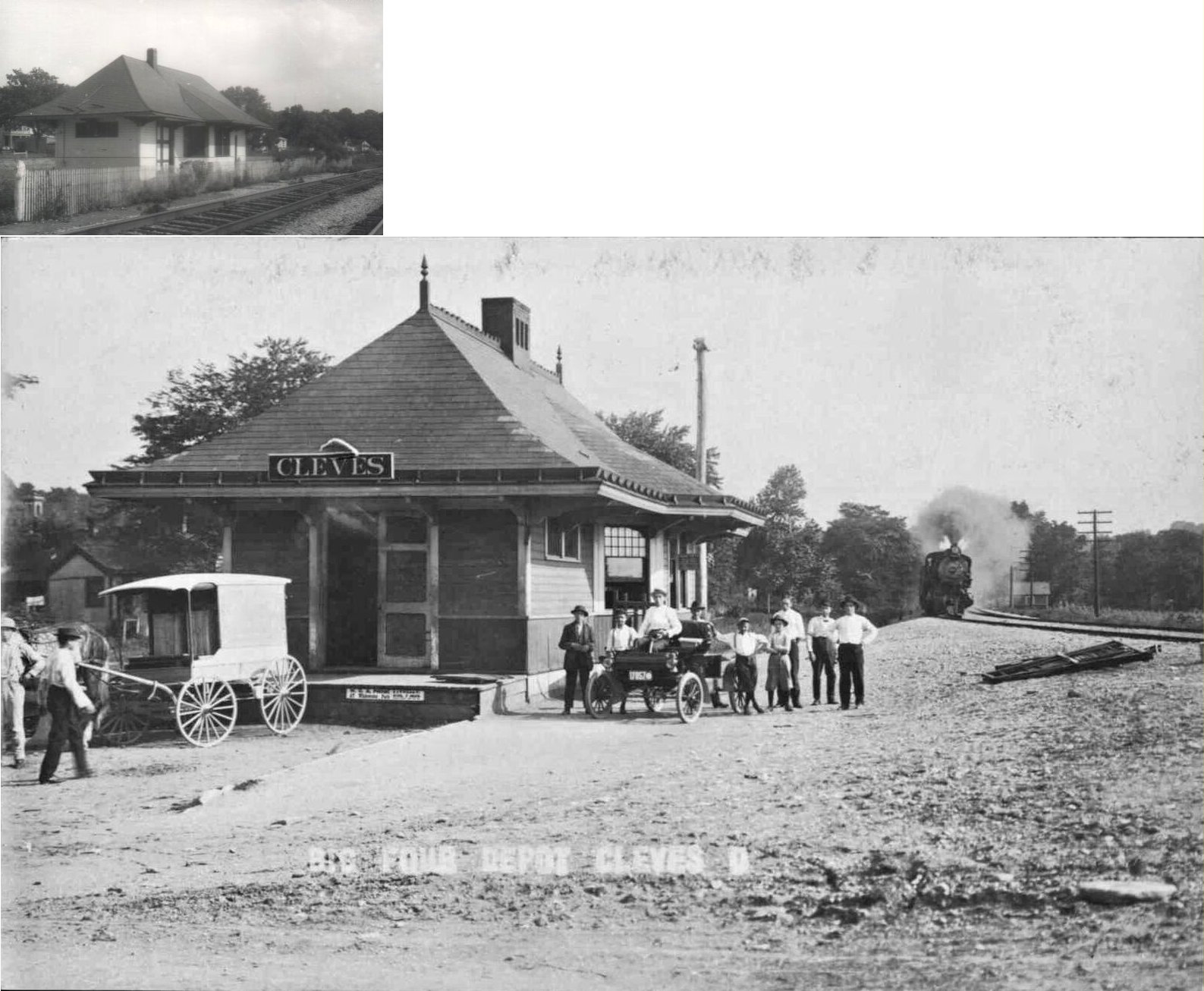
| Cleves |
|
This station, which sat on the south side of West State Road (US 50) about a block to the west of South Miami Ave., was used as an antique store called the "Coal Hole" then sold to someone selling fruits. When the fruit seller wanted to expand his business the building wouldn't pass inspection for selling meat, etc. So it was sawed in half- front to back- and all the equipment inside was moved to one side and the other side torn down and rebuilt, with a cinder block foundation for a wider building. Then the equipment inside the other original half was moved to the new half and the old half was torn down. After this store went out of business it was sold to the "Dental Depot" which added the bay window- on the parking lot side- and the platform - again on the parking lot side. The track side of the building is all cinder block. So the "station" that exists in Cleves today is a fake station. It is only built on the site of the old depot. --Bob Deffinger | ||||||
| Columbia |
|
|||||||
| Cullom |
|
This local commuter station was about one mile upriver from Anderson Ferry. | ||||||
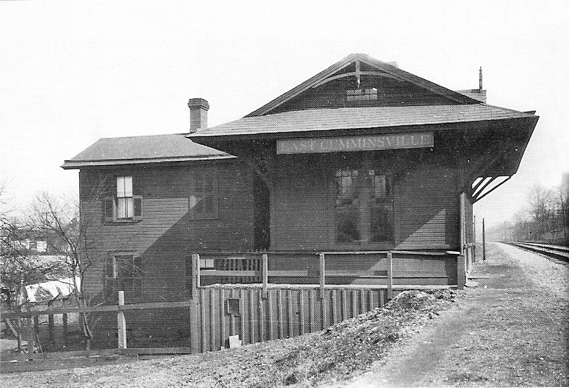
| Cumminsville |
|
This station was on the east side of Colerain Avenue on the NW side of the tracks at GPS: 39.152955, -84.540730. This part of Colerain Avenue has been replaced by the current I-74 approach crossing Mill Creek. This station may have also served the CCC&St.L as that RR had trackage rights here. This station was less than a mile from the East Cumminsville station (listed below). | ||||||
| Cumminsville (East Cumminsville) |
|
This station was on the south bank of Mill Creek on the north side of the tracks. In the photo the creek would have been directly behind the station which has a two-story stationmaster dwelling attached. It was across the creek and approximately 300-500 yards from the intersection of Spring Grove Avenue and Dane Avenue. This area is now beteen I-75 and Mill Creek and is inacessible by any streets. The station was at approximately GPS: 39.158888, -84.532332. | ||||||
| Crescent |
|
This was a local commuter station near Delhi that was apparently shuttered early on. | ||||||
| Crescentville |
|
|||||||
| Crestvue |
|
|||||||
| Daters |
|
This station was between Eckerts and LaFeuille. | ||||||
| Deer Park |
|
This large, two-story station was on the corner of Blue Ash Road and Webster Avenue. It was on the west side of the tracks at GPS: 39.198810, -84.399162. | ||||||
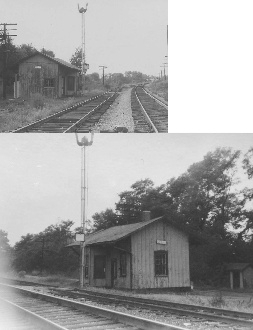
| Delhi |
|
The Cincinnati & Whitewater Canal leased trackage rights on their towpath to the O&M RR. Construction began around 1851 and Delhi was an early station. It was at Revere & Nokomis (a by-way that paralleled River Road (U.S. 50), one block away from what is now Gracely Drive. Delhi became one of a few Ohio stops for O&M accommodation trains that mostly catered to Indiana residents. The station remained a modest wooden structure through the B&O years until commuter service ended circa 1934. The Ohio & Mississippi laid tracks through this site in the early 1850’s and established a station stop. The village of Delhi was incorporated in 1885 and annexed by the City of Cincinnati in 1910. It is 10.6 miles to the city, Central Union Station. --Joe Kyle | ||||||
| Delhi |
|
The B&O and Big 4 stations were near where Revere Avenue junctions with US-50 at approximately GPS: 39.106812, -84.688870. | ||||||
| Delhi |
|
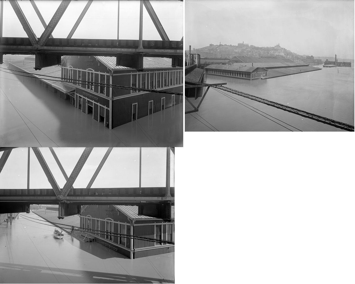
In a complicated and controversial move, a predecessor railroad to the Big Four bought the bankrupt Cincinnati & Whitewater Canal Company in 1863, ceased canal operations and leased the canal bed for rail use to another Big Four predecessor line. A depot was built across the tracks from the O&M (later the B&OSW then the B&O). This served the needs of Big Four commuters until service ended circa 1934 due to lack of demand. --Joe Kyle The photo shows the Delhi Big 4 station across from the B&O station during the 1913 flood. These stations were near where Revere Avenue junctions with US-50 at approximately GPS: 39.106812, -84.688870. | ||||||
| Eckerts |
|
This station was between Daters and Orrs. | ||||||
| Edgemont |
|
|||||||
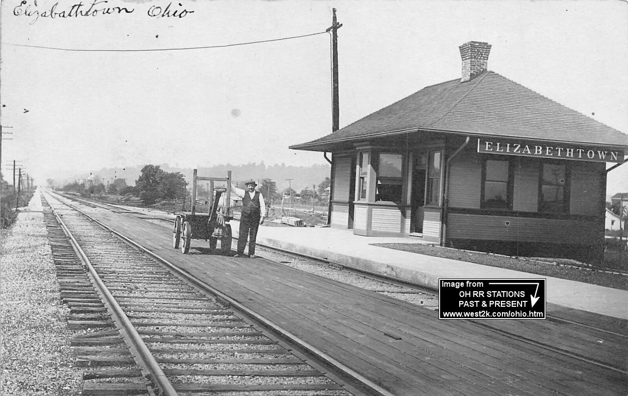
| Elizabethtown |
|
This station was on the west side of Geist Rd. (Lawrenceburg Rd.) on the north side of the tracks. | ||||||
| Elmwood Place |
|
The station was on the NW side of McGregor on the SW side of Center Hill (Township Avenue). The station was on the SE side of the tracks. | ||||||
| Elmwood Place |
|
|||||||
| Euclid |
|
|||||||
| Evanston |
|
A new passenger shelter was built here in 1913 according to the railroad's annual report from that year. It likely was not in service very long. | ||||||
| Evendale |
|
|||||||
| Fairmount (Stock Yards) |
|
This station was at the old intersection of Cummins and Carll Streets at GPS: 39.134400, -84.545720. | ||||||
| Fairmount |
|
The C&W was a short, narrow-gauge steam line that began in 1874 primarily to serve Westwood. It converted to standard gauge in 1891, ended service in 1924, and was mostly torn up by 1941. This station was between Brighton and St. Francis. | ||||||
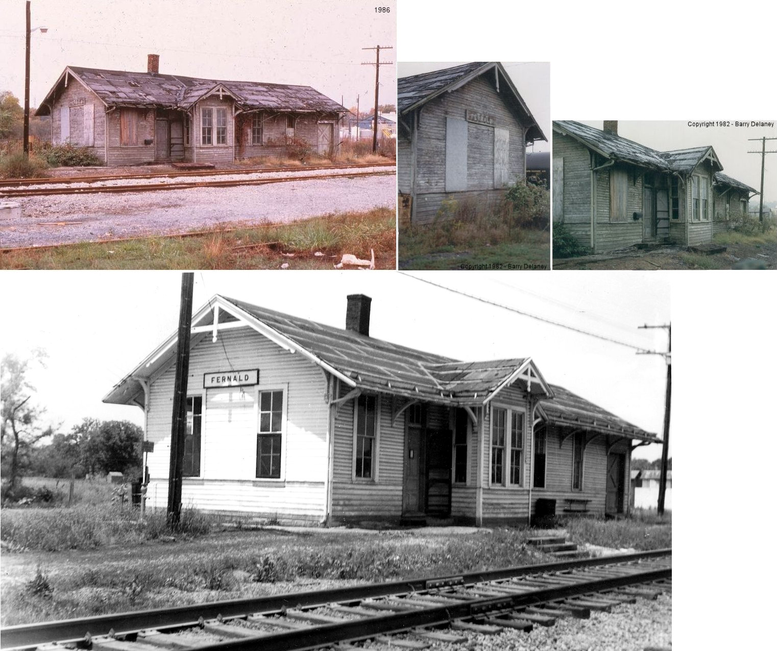
| Fernald |
|
Fernald was located on the Cinci-Chicago line between Chevoit and Shandon. Chessie System abandoned this part of the line (between Cinci and Fernald) in 1978. | ||||||
| Fernbank |
|
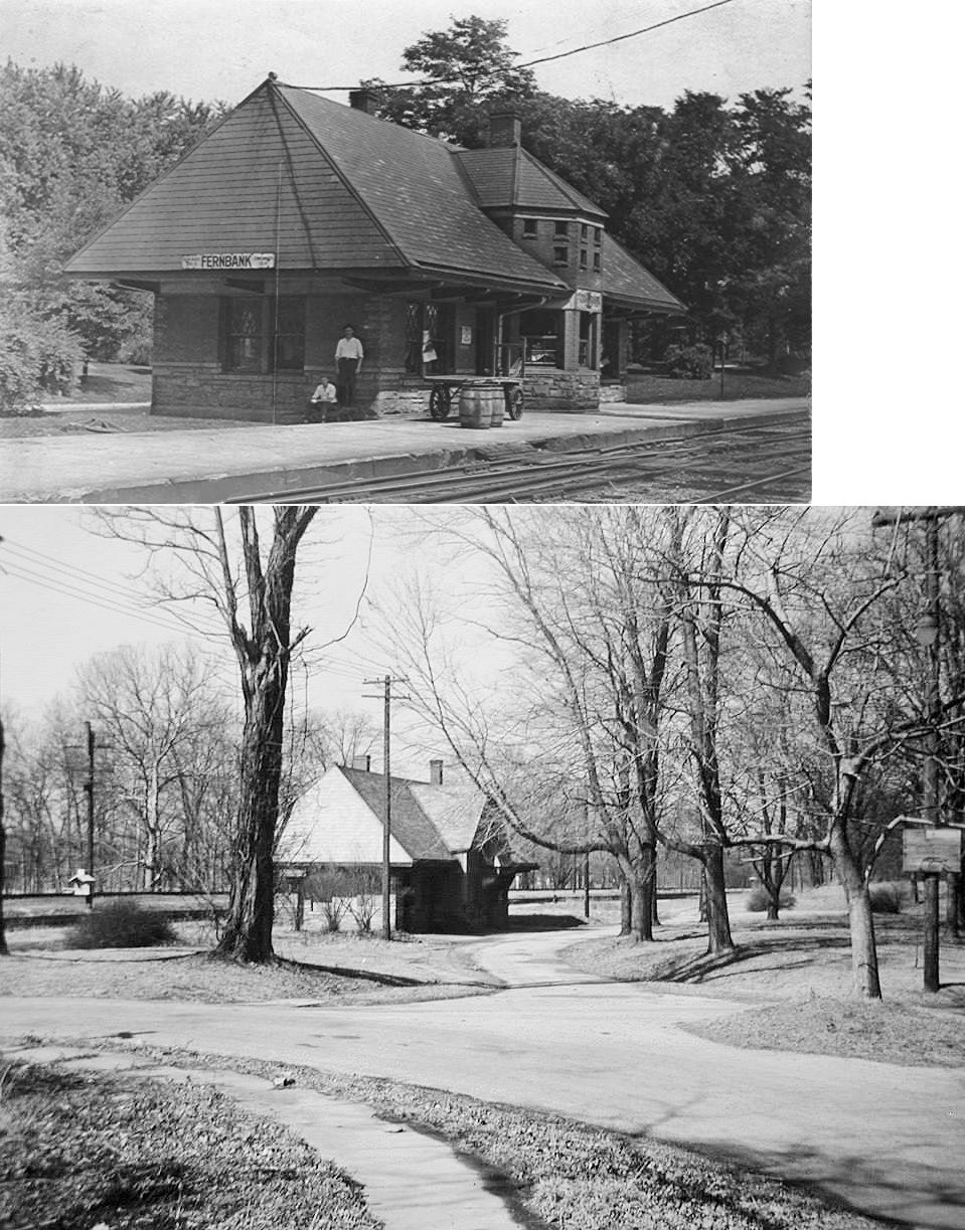
Fernbank was originally known as Fern Bank until the USPS directed in 1894 that the two word name become one. Fernbank was annexed by the City of Cincinnati, together with its neighboring independent villages, Delhi and Home City (Sayler Park) in the years 1910-1912. In 1881 at Fernbank, a handsome brick combination passenger/freight station replaced a modest wooden structure built circa 1865. The earlier building went up soon after a predecessor line to the Big Four acquired trackage rights in the bed of the defunct Cincinnati-Whitewater Canal. The station was located on Nokomis Avenue This was a byway that fronted the tracks at Catalpa Road. The site is one block from Old River Rd (then U.S. 50), now Gracely Drive. The Fernbank station closed circa 1933. A telegrapher used the station into the late 1940s. It remained a flag stop into the early 1950s. In the mid 1950s the station was demolished to make room for the Three Rivers Parkway (new U.S. 50). --Joe Kyle | ||||||
| Forestville |
|
|||||||
| Glendale |
|
The original frame station here burned in 1879 and the new station was constructed at the same site (Greenville Avenue at Village Square). | ||||||
| Glenmore |
|
This station was on the west side of Glenmore Avenue about halfway between Daytona and Broadwell Avenues. The C&W was a short, narrow-gauge steam line that began in 1874 primarily to serve Westwood. It converted to standard gauge in 1891, ended service in 1924, and was mostly torn up by 1941. | ||||||
| Grainthorpe |
|
|||||||
| Gravel Pit |
|
According to N&W valuation records, the station was built in 1906. It was on the east side of Mt. Carmel Road on the north side of the tracks at GPS: 39.148109, -84.312203. | ||||||
| Griffith |
|
The photo is likely (although not certain) of Griffith's Station. Old maps show Griffith Station at MP 483.8 (miles from Pittsburgh) on the right bank of the river next to the Marmet & Smith Coal Elevator at MP 484.1. Other stations along this line did not sit so close to the river. | ||||||
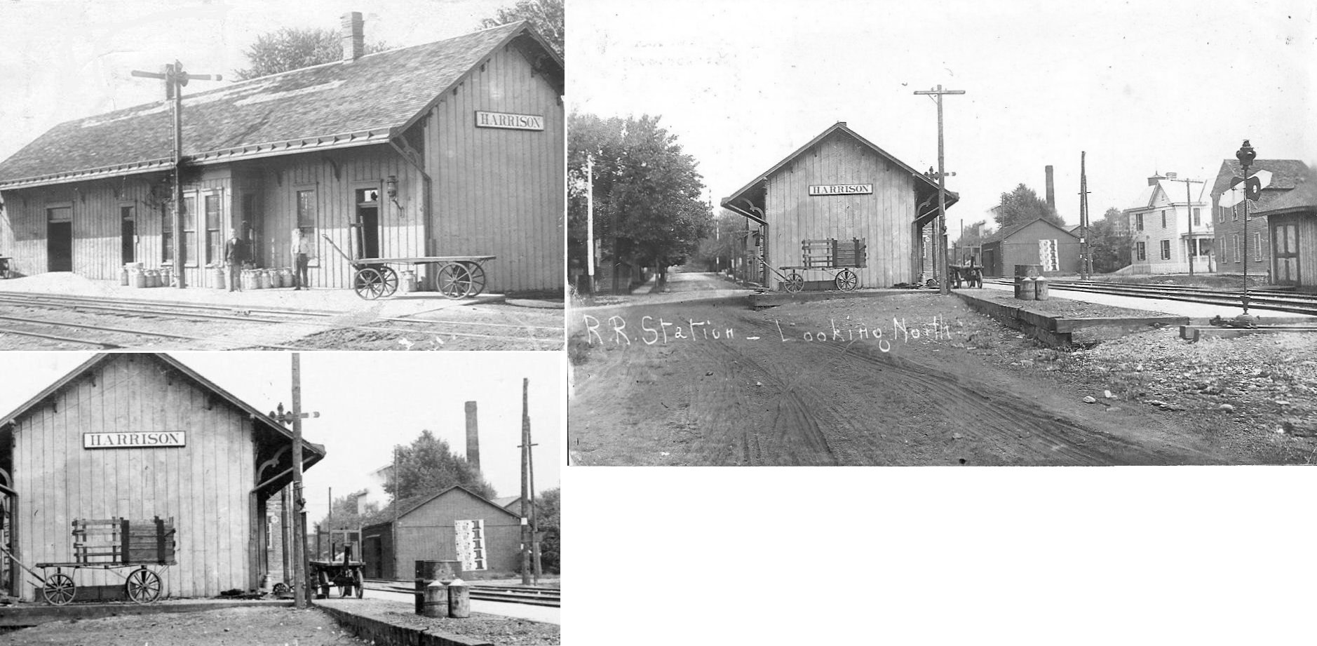
| Harrison |
|
This station was on the south side of Broadway Street at the intersection of Railroad Avenue. It was on the west side of the tracks. It may have been built by the White Water RR (pre-CCC&St.L). | ||||||
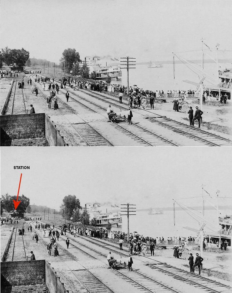
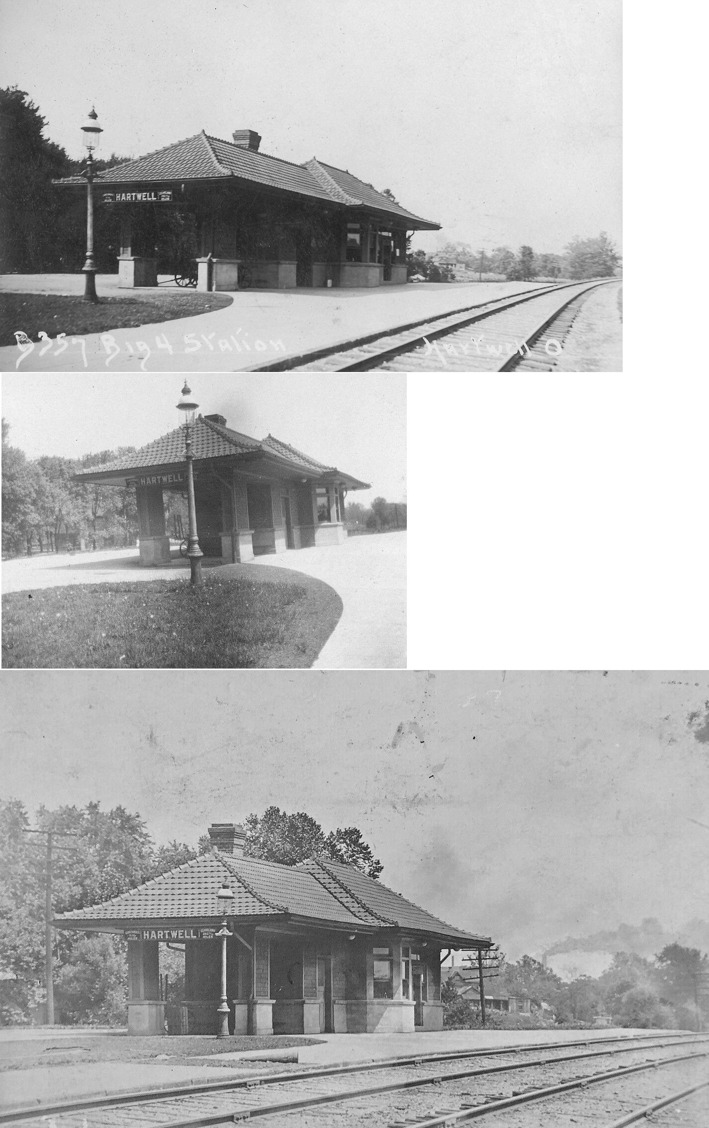
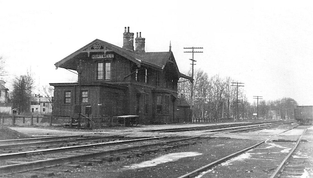
| Hartwell |
|
This station was at the intersection of Anthony Wayne Avenue and Hartwell Avenue at GPS: 39.212227, -84.463403. | ||||||
| Hartwell |
|
|||||||
| Hazlewood (Rowena) |
|
The name of this station was changed from Rowena to Hazlewood in 1881. | ||||||
| Holabird |
|
This station was between Trautman and Anderson's Ferry. | ||||||
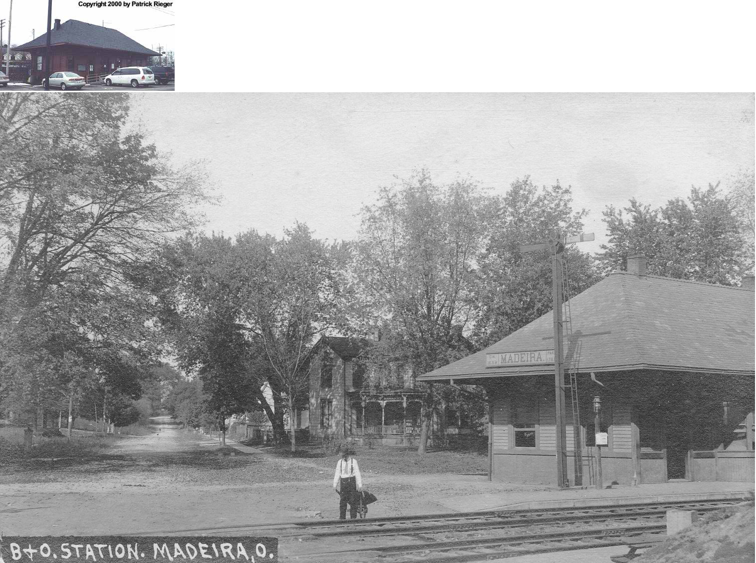
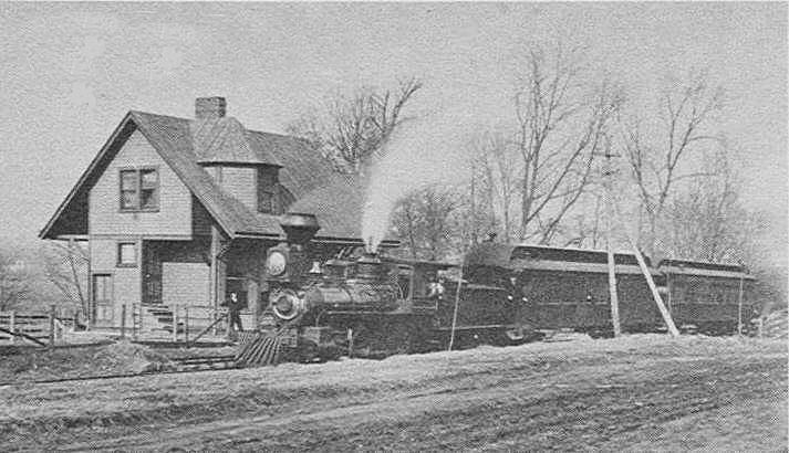
| Home City (Sayler Park) |
|
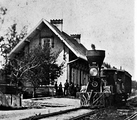
The Home City station (renamed Sayler Park circa 1911 to honor a prominent local citizen) was on Nokomis Avenue, a byway that fronted the tracks, at Monitor Avenue. The station was one block from Old River Road (U.S. 50), now Gracely Drive. No doubt some structure served this site soon after a predecessor line began service here soon after 1863. However, the attractive brick building shown in the photograph dates from the 1880s. It served a commuter clientele until a dramatic drop in demand through the 1920s led to closure circa 1934. The building was demolished not long afterward, perhaps after the disastrous 1937 flood. --Joe Kyle | ||||||
| Hunt's Grove |
|
|||||||
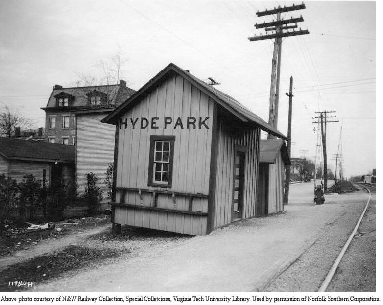
| Hyde Park |
|
According to N&W valuation records, it was built in 1906. The station was at the intersection of Edwards Road and Wasson Road at approximately GPS: 39.144722, -84.442639. | ||||||
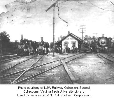
| Idlewild |
|
|||||||
| Idlewild |
|
Idlewild is now part of Cincinnati. It was located just south of Norwood. Another photo with engines lined up. This station was built in 1891 according to N&W valuation records. | ||||||
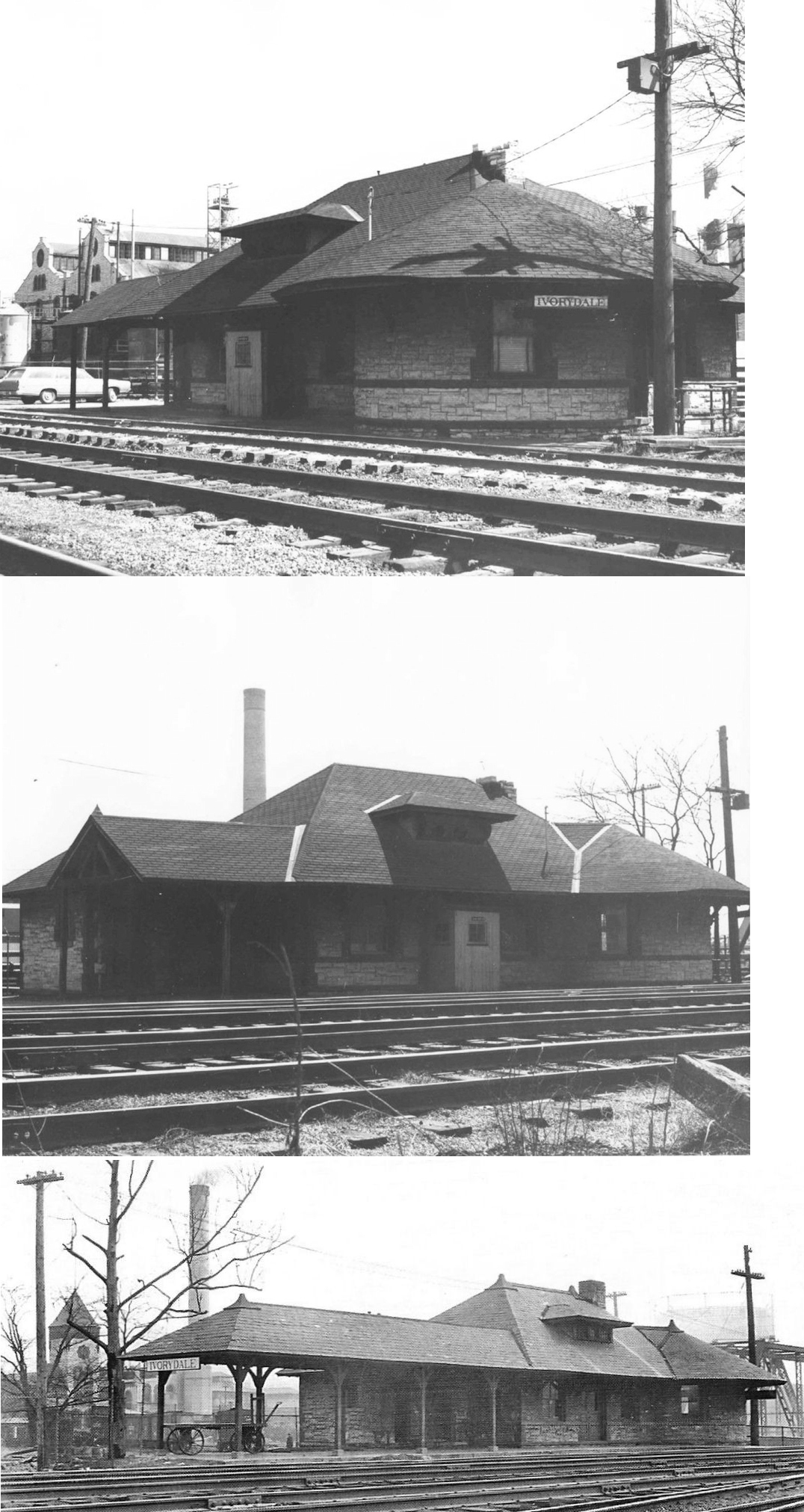
| Ivorydale |
|
This station was just outside the gates of Proctor & Gamble. | ||||||
| Ivorydale |
|
|||||||
| Ivorydale |
|
According to valuation records, a three-story brick freight station was built here in 1881. | ||||||
| Kennedy |
|
|||||||
| LaFeuille |
|
This station was between Daters and Werks. | ||||||
| Lester |
|
|||||||
| Linwood |
|
A new station was built here in 1859. | ||||||
| Linwood |
|
This station was on the north side of Beechmont Avenue, on the east side of the tracks at GPS: 39.120146, -84.416518. The first station here was built in 1859. | ||||||
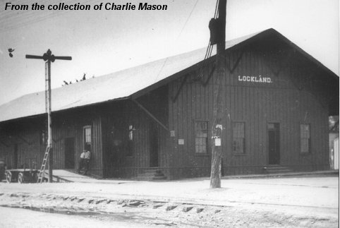
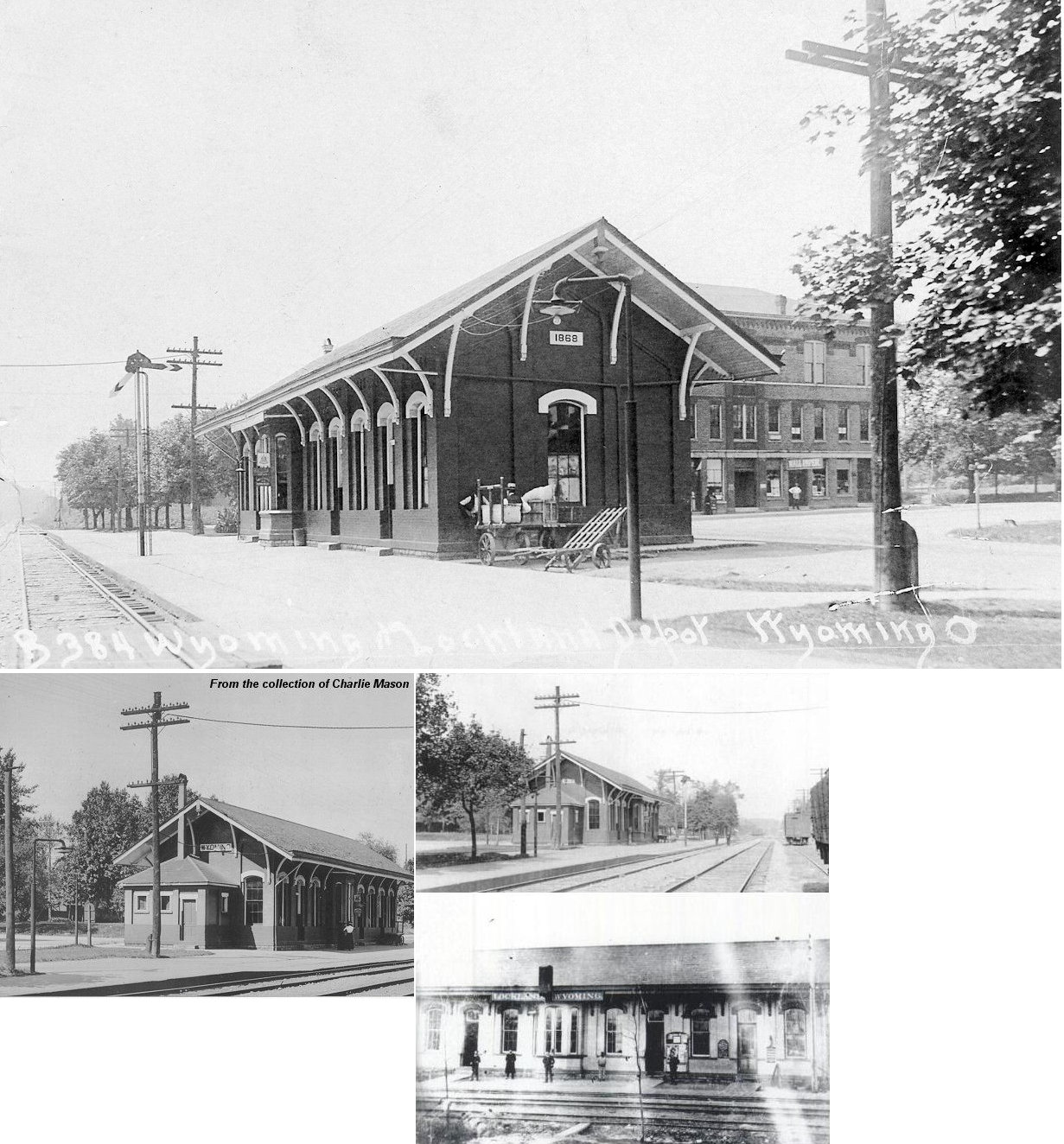
| Lockland |
|
During the 1937 flood when the new Cinci Union Terminal (Jan 1937) was flooded, all service on NYC originated from Lockland destined to Chicago, Detroit, Cleveland and New York. Burned down in 1961. The station was located on the south side of Dunn Street, on the west side of the tracks. | ||||||
| Lockland |
|
This station was located between Worthington and Wyoming Streets on the west side of the tracks. | ||||||
| Longview |
|
|||||||
| Lyndchester |
|
|||||||
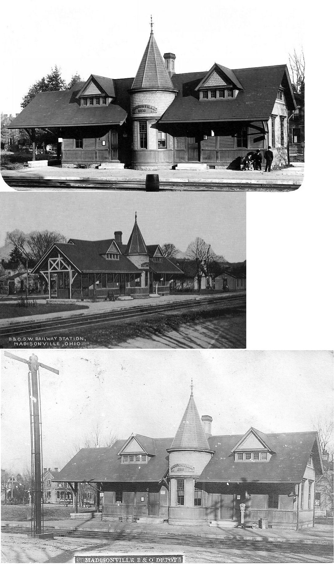
| Madisonville |
|
This station was on the corner of Peabody Street and Orlando Place. It was on the north side of the tracks. It was gone by 1917. | ||||||
| Madisonville |
|
This station was on the south side of Madison Road, just west of Stafford Street. It replaced the station listed above. | ||||||
| Madisonville (E. Madisonville) |
|
|||||||
| Madisonville |
|
|||||||
| Maplewood |
|
|||||||
| MAPLEWOOD |
|
|||||||
| Mariemont |
 |
See the listing for Red Bank below. | ||||||
| Mc Cullough's |
|
|||||||
| Miami |
|
Miami was a station on the CC&L, the Chicago, Cincinnati, & Louisville, which began service from Cincinnati to Chicago on April 7, 1907. On June 23, 1910, after more than two years in receivership, the CC&L was sold to the C&O, and the line was separately incorporated, effective July 2, 1910, as the Chesapeake & Ohio Railway Co. of Indiana. The line was transferred on Oct. 1, 1934, from the Chesapeake & Ohio Railway Co. of Indiana to its parent company, the Chesapeake & Ohio. On July 17, 1978 the tracks were severed east of Brighton (near downtown Cincinnati. The line was run from end-of-track in Brighton, through Cheviot (formerly Summit, west of Cincinnati) and Fernald (near the Butler County line), through Cottage Grove, to Richmond, IN. Virtually the entire line was torn out during the 1980s, and today only the remnant between Fernald and Cottage Grove (an interchange with the former B&O) is in operation. The Miami station was taken out of service many years ago, and was moved to a farmer's field just west of its location along the railroad next to U.S. 52. Sometime around 1969-1971, the station caught fire and was totally destroyed. --Mike Brestel | ||||||
| Miami Grove |
|
|||||||
| Milford |
|
|||||||
| Montgomery |
|
This station was 1/2 block north of Cooper Avenue west of State Street. The trains backed up to the station here as it was near the end of two spur tracks. | ||||||
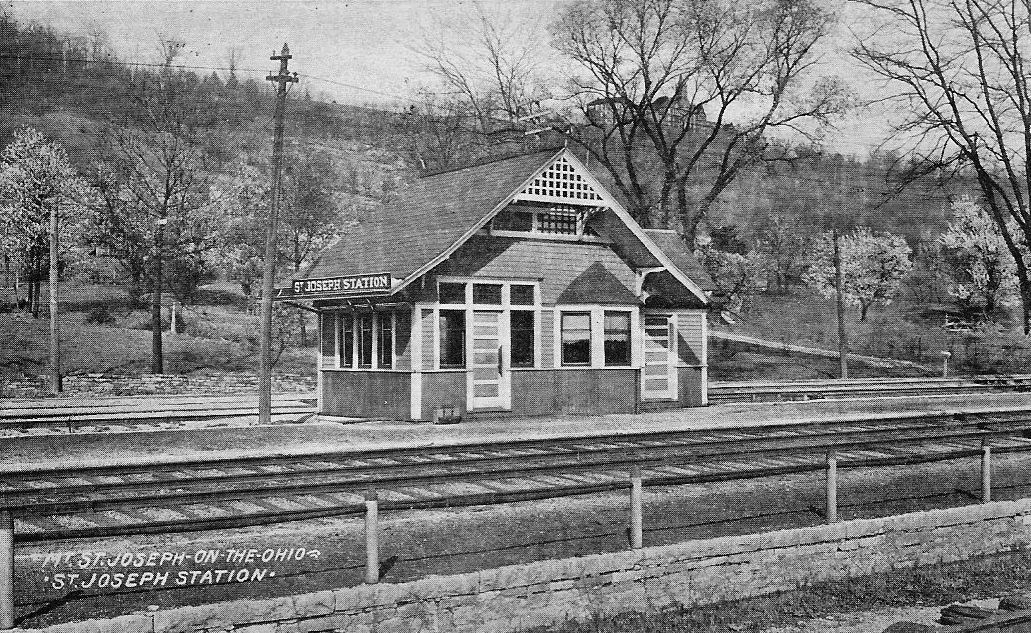
| Mount Saint Joseph |
|
This small commuter station served a private Roman Catholic women's college seen through the trees above the station in the photograph. It was located off of old Lower River Road (U.S.-50) at Wocher Avenue. | ||||||
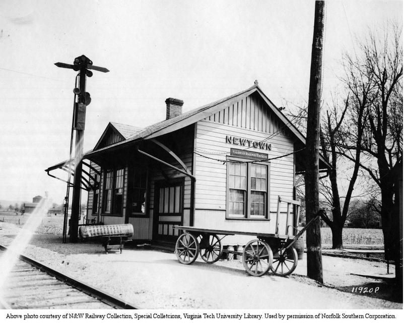
| Newtown |
|
According to N&W valuation records, it was built in 1896. | ||||||
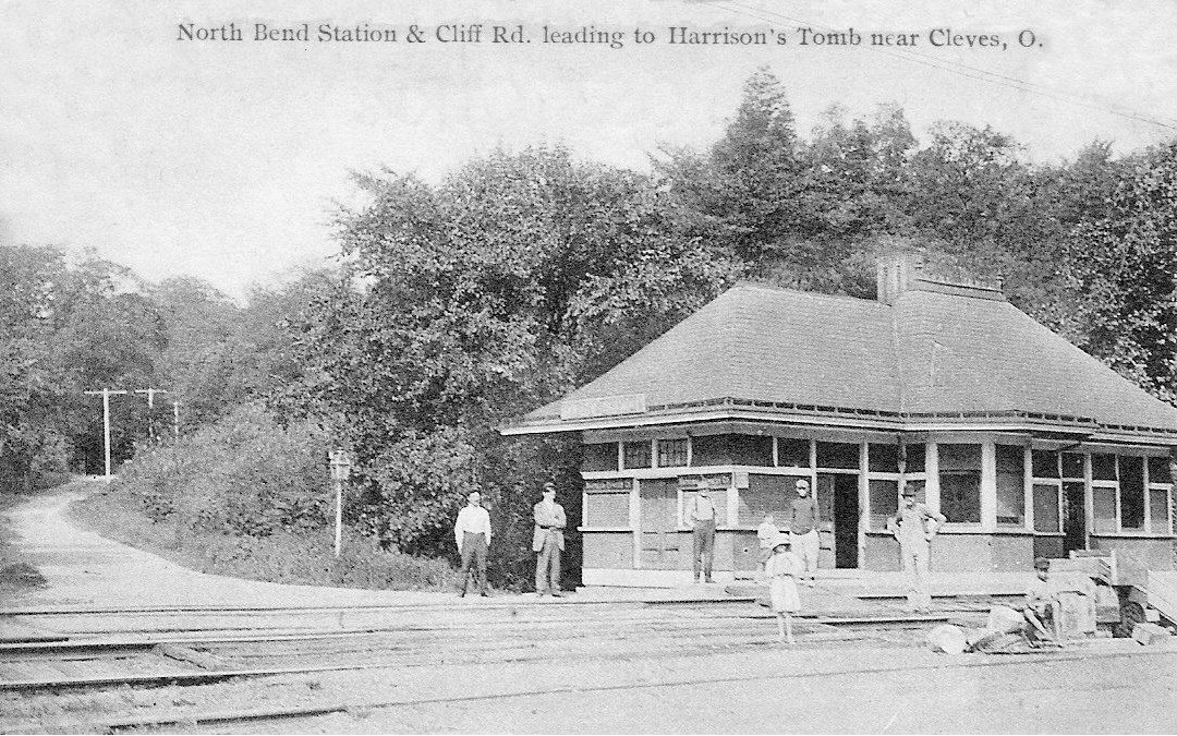
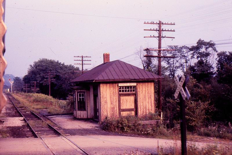
| North Bend |
|
Although the photo implies that this station was on Cliff Road, the Sanborn Fire Map of 1938 shows the station actually sat on the north side Brower Road on the west side of the tracks. The Big Four used the tunnel under North Bend Hill until the mid 1880s. Then, with an agreement with the B&O SW, the B&O cut was enlarged to accommodate the Big Four and the Big Four station was moved to along the relocated track. It’s uncertain which station is shown in the photo. | ||||||
| North Bend |
|
|||||||
| Norwood |
|
This was the first B&O station at Norwood. It was at Foraker and Station Avenues. | ||||||
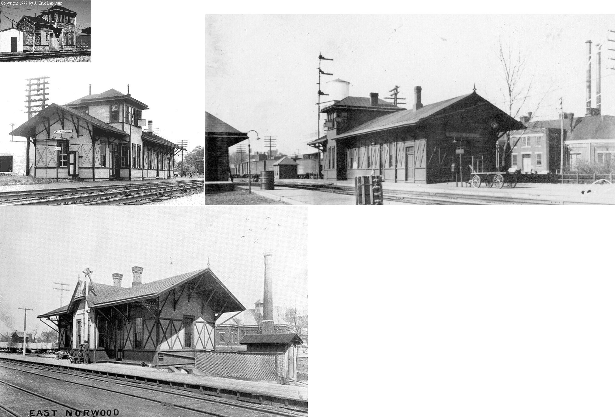
|
Norwood (E. Norwood) |
|
This passenger station, which was later GK tower, was on the west side of Forest Avenue south of Harris Avenue behind Zubiel Box Factory and was built in 1873. The station was built first, then the tower part was added later. The twoer part was then the last part of the station standing. The station was in the eastern quadrant of the B&O/CL&N diamond. The remaining part of the station (GK tower) was burned by vandals in late May 2000. There was a freight station across the tracks to the south. | ||||||
| Norwood |
|
There was a freight station at Smith and Montgomery Streets. | ||||||
|
Norwood Park (Smith Road) |
|
This station was located at the corner of Smith Road and Lafayette Avenue
approximately where the Surrey Square strip mall sign is today. There was
also freight station here, about 100 yards north of the passenger station
on a siding that ended at Smith Road and Sherman Avenue. There were four CL&N stations in the Norwood area. They were, from south to north, Ivanhoe, Hopkins Avenue (still standing), Norwood Park (this listing) and East Norwood. |
||||||
|
Norwood (EAST NORWOOD) |
|
This station was on Froest Avenue just south of Harris Avenue. It was just to the north of the B&O station. Both stations were in the east quadrant of the diamond, with the B&O being closer to the actual diamond and the CL&N station being aabout 50 feet to the north. | ||||||
|
Norwood (Ivanhoe) |
|
|||||||
| Norwood |
|
According to N&W valuation records, new passenger and freight stations were built in 1901. | ||||||
| Norwood |
|
This freight station was at 1945 Lexington Avenue (GPS: 39.147056, -84.463649). | ||||||
| Norwood Heights |
|
|||||||
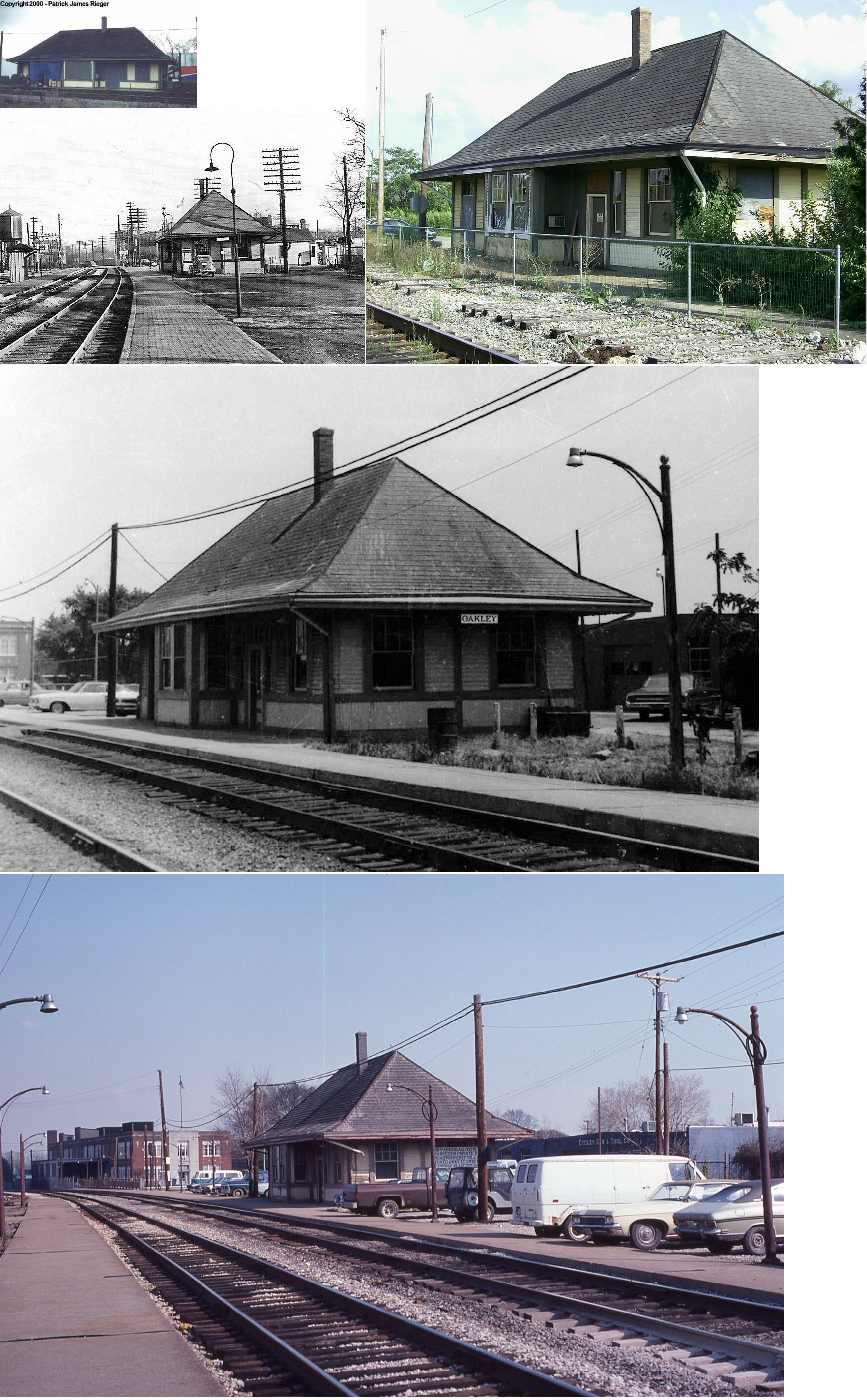
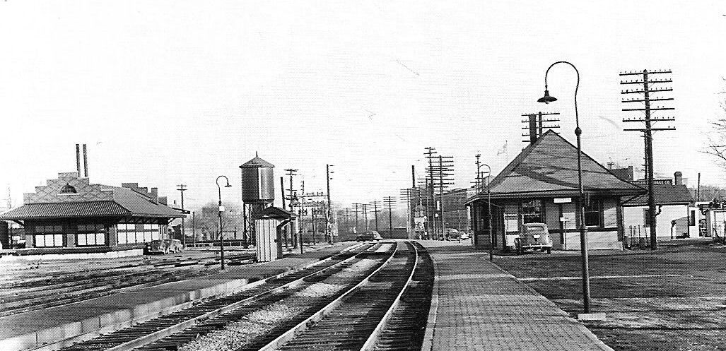
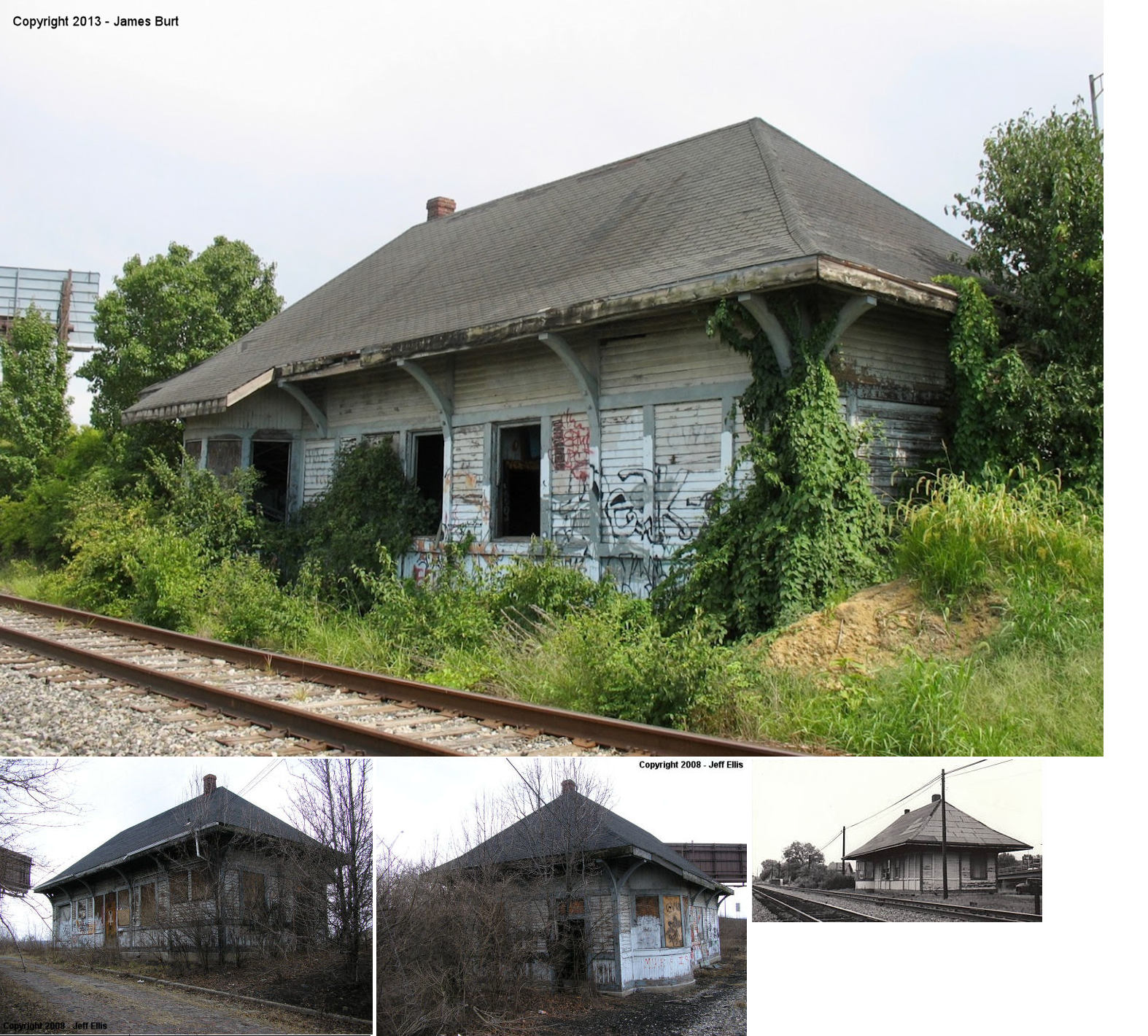
| Oakley |
|
Built in 1871, this station was at 3224 Enyart Avenue (GPS: 39.156001, -84.426803). Passenger service ended in 1971 and it served as a recycling business until 2008. It was the last suburban station to have a stop during passenger service. It was demolished on July 11, 2013. | ||||||
| Oakley |
|
The freight station was across the tracks to the northeast of the passenger station on Forrer Street. There is a parking lot at this site now. | ||||||
| Orrs |
|
This station was between St. Peterstown and Eckerts. | ||||||
| Park Place |
|
This station sat between the tracks and Mill Creek. A bridge spanning the creek allowed passengers to access the station from the Park Place development. | ||||||
| Plainville |
|
This combination station/post office was south off Wooster Pike at Walton Creek Road (formerly Miami Street). | ||||||
| Pleasant Ridge |
|
|||||||
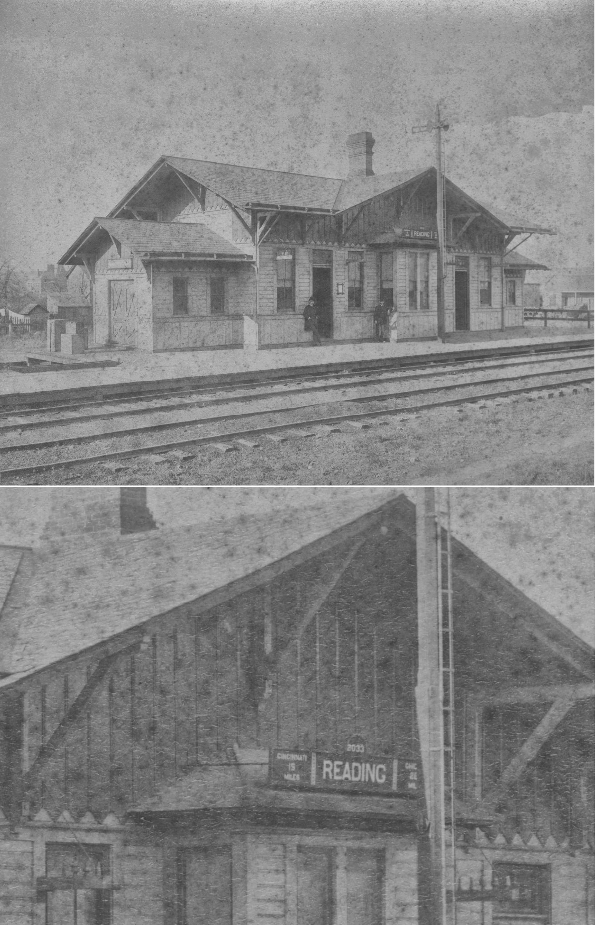
| Reading |
|
This may have been an older station. | ||||||
| Reading |
|
This station was on the north side of East Vine Street on the west side of the tracks. | ||||||
| Red Bank |
|
|||||||
| Red bank (Mariemont) |
|
This station was likely built during the CP&V years as the sign board pictured matches other CP&V signborads. It ws later used as a section foreman's house by the N&W. Only a platform was listed here in the 1916 valuation records. | ||||||
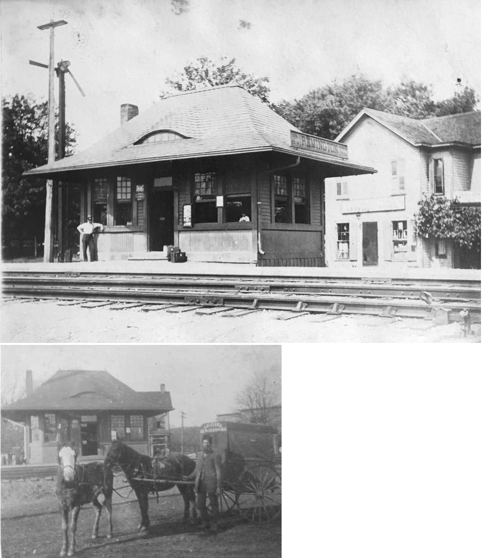
| Remington |
|
|||||||
| Rensselaer |
|
|||||||
| Riverside |
|
Riverside was an independent village until annexed by the City of Cincinnati in 1893. It was a narrow band along the Ohio River from Bold Face Creek to Anderson Ferry Road. The station was located close to Bold Face Creek and served commuters until loss of demand caused its closure around 1934. | ||||||
| Robbs |
|
This station was .6 of a mile past Glenmore. | ||||||
| Rossmoyne |
|
|||||||
| Sayler Park |
|
See listing above for Home City. | ||||||
| Sedamsville |
|
Sedamsville is a small neighborhood that was annexed by the City of Cincinnati in 1869. It adjoins Riverside at Bold Face Creek. The station was close to the creek and barely 1/2 mile from the Riverside station. It too served commuters, but closed with the decline in demand. | ||||||
| Sekitan |
|
Although the station is long gone, the name survives locally. The word "Sekitan" is Japanese for coal. At the time Japan was a big buyer of WV coal. Addyston and North Bend were also big coal transfer points on the line. | ||||||
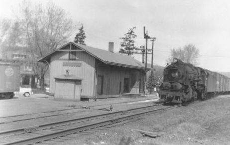
| Sharonville |
|
This station was on the east side of Reading Road (Main Street) directly across from the end of Hageman Street. It was on the east side of the tracks behind a farm implement dealer (now gone). As of 2010 there was a mobile home on the site of the station. | ||||||
| Silverton |
|
This station was on Montgomery Avenue between Highland Avenue and Parkview Lane. It was on the NW side of the tracks. There is now a replica station there on the SE side of the tracks. | ||||||
| Simonson |
|
There was likely no station here, but there was a four car siding. | ||||||
| Southside |
|
Southside was a commuter station along the Ohio River about 9/10 mile below Bold Face Creek in Riverside, a village annexed by the City of Cincinnati in 1893. It was a part of the village of Riverside, named because it was south of the railroad tracks fronting the river. Late in the 19th Century, Southside was blessed with the Fleischmann Yeast plant, a distillery, a large barrel making plant and rolling mill. After major floods in 1883 & 1884, the yeast plant and distillery moved, and the other employers closed when industrial practices changed or raw materials played out. Usage at the Southside station declined, and at the nearby stations of Riverside and Sedamsville as well. --Joe Kyle | ||||||
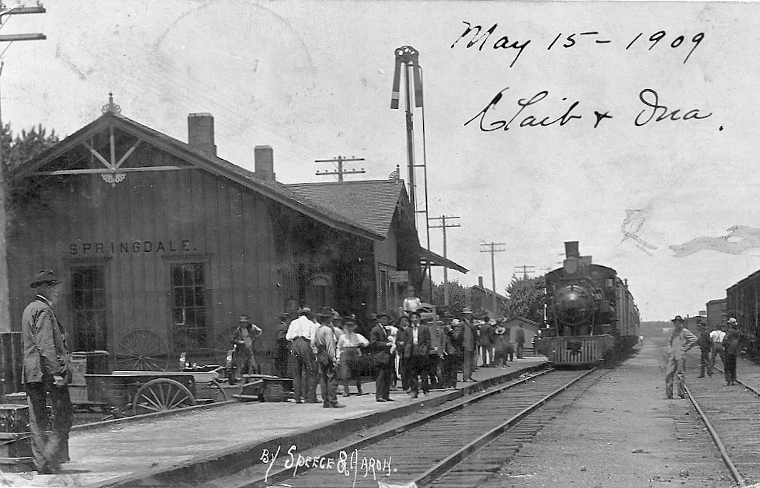
| Springdale |
|
|||||||
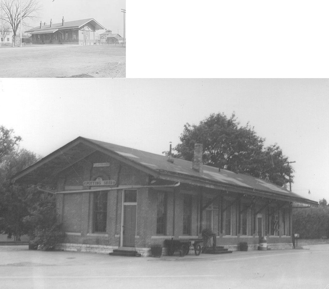
| St. Bernard |
|
This station was on the west side of Vine Street at Oak Street at GPS: 39.171924, -84.497500. It was torn down sometime around 2018-2020. | ||||||
| St. Francis |
|
This station was between St. Peterstown and Fairmount. | ||||||
| St. Peterstown |
|
This station was between St. Francis and Orrs. | ||||||
| Storrs |
|
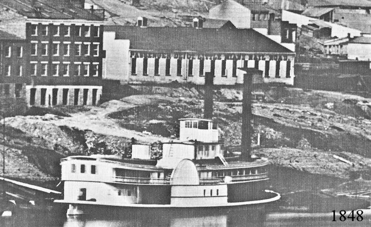
This Ohio & Mississippi station was located on Mill Creek just across from the growing center of Cincinnati. For a few years Storrs seems to have been the terminus, and passengers were taken across the creek to board the train. Other early stations in Ohio were at Delhi, North Bend, and Gravel Pit on the Indiana line. By the end of 19th Century, Storrs was a tangle of railroad tracks and service buildings. Storrs station continued to receive mention, but may have served employees coming on and off shift rather than revenue passengers. Twentieth Century B&O literature mentions Storrs Junction and Storrs Yard, suggesting a changed use of the site. The O&M when chartered, and although badly undercapitalized, intended to extend a broad gauge rail connection west from Cincinnati to St. Louis. The service would have created continuous broad gauge service from Baltimore to the Mississippi. Mid-Atlantic business interests wanted to meet competition from the Erie Canal. The first O&M through train service from Cincinnati to the Mississippi began in 1857. Broad gauge service ended a few years later. -- Joe Kyle | ||||||
| Symmes |
|
|||||||
| Tell Cottage |
|
This station was between Anderson's Ferry and Cullom. | ||||||
| Terra Alta |
|
|||||||
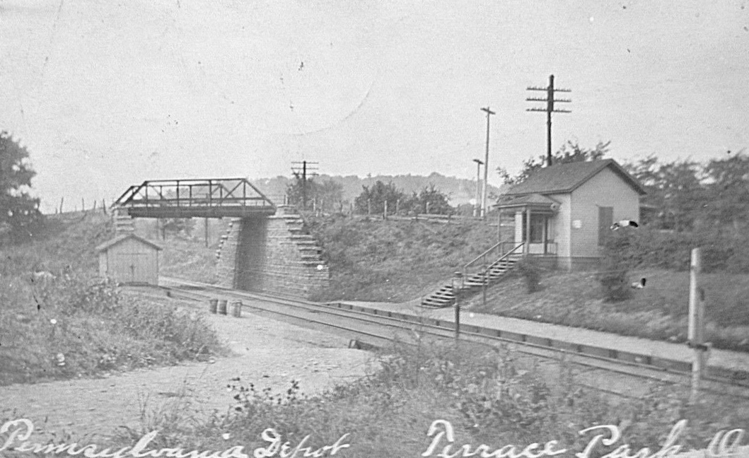
| Terrace Park |
|
This station was on the east side of Elm Avenue. It was on the NW side of the tracks. | ||||||
| Trautman |
|
Trautman Station was a commuter station on the Big Four, Chicago Division along the Ohio River between Anderson Ferry and St. Joseph stations. It also served the nearby College of Mount St. Joseph. An early 20th century passenger timetable shows Trautman as a flag stop. For a time Trautman had been of local importance because Neeb Road gave access, serving both truck farmers producing for the Cincinnati market and commuters. However, the road was a steep descent down the bluff and frequently washed out. The descending portion was closed with the coming of the automobile. --Joseph Kyle | ||||||
| Tusculum |
|
This station was on the north side of Congress Avenue near the intersection with Eastern Avenue. The station was on the west side of the tracks. Congress Avenue no longer is a through street here so it no longer intersects with Eastern. The area where the station was is now a wooded lot at the end of Congress and Stacon Streets. | ||||||
| Tweedville |
|
The N&W may have connected with the B&O here. | ||||||
| Twightwee |
|
|||||||
| Valley Junction |
|
This station was demolished in 1930 after going out of service. | ||||||
| Werks |
|
This station was between Westwood and LaFeuille. | ||||||
| Westwood |
|
The C&W was a short, narrow-gauge steam line that began in 1874 primarily to serve Westwood. It converted to standard gauge in 1891, ended service in 1924, and was mostly torn up by 1941. | ||||||
| White Water Park |
|
There's no evidence that there was an actual station building here. The current location of Whitewater Park on the former NYC Whitewater Division was referred to as Riffner's or Riffner Station from at least 1869 until around 1896 when it was referenced as Whitewater Park. It had a 25 car siding capacity and was a popular excursion destination with as many as 35 coaches arriving there during holidays and on Sundays. | ||||||
| Winslow Park |
|
|||||||
| Winton Place |
|
This station was closed in 1933. | ||||||
| Winton Place |
|
|||||||
| Wyoming |
|
This station was at the end of Poplar Avenue just east of Crescent Street. | ||||||
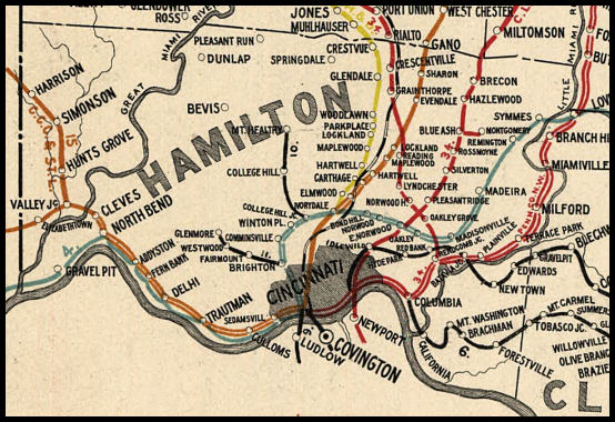
| 1898 HAMILTON COUNTY RAILROAD MAP | ||||||||
 |
||||||||
|
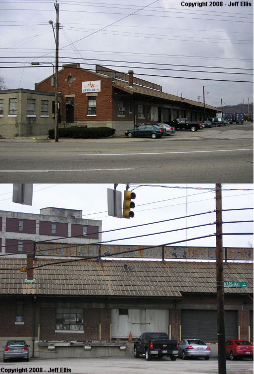
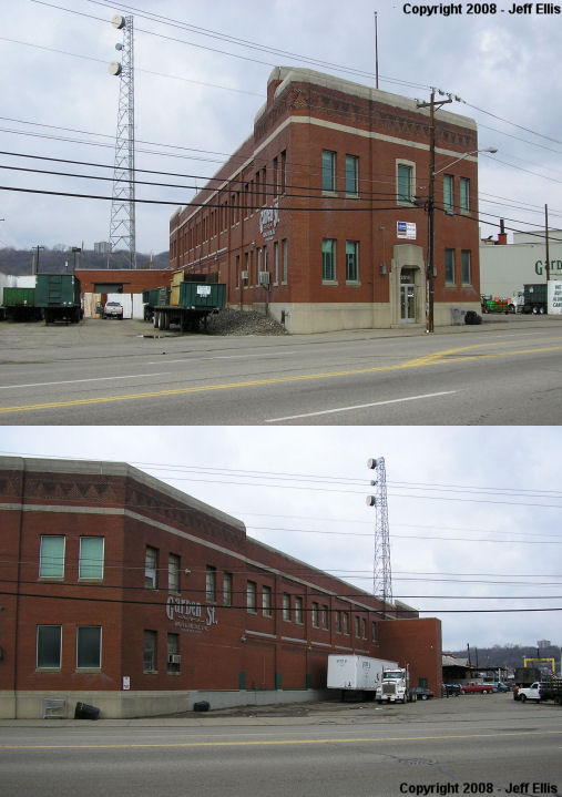
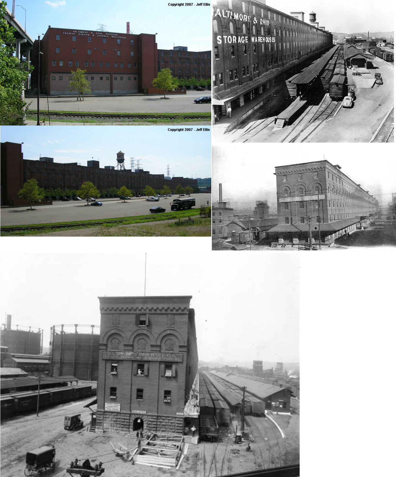
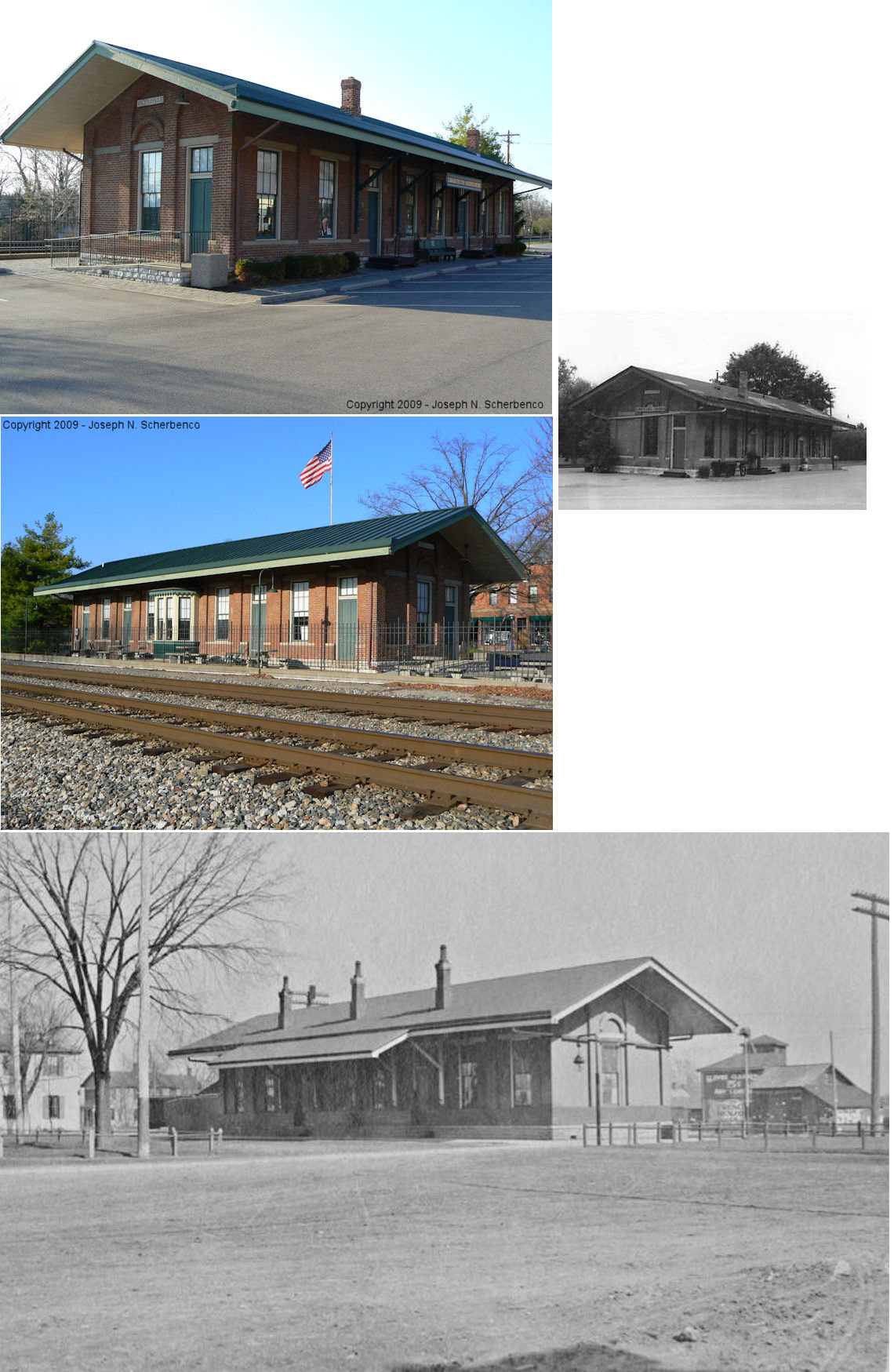
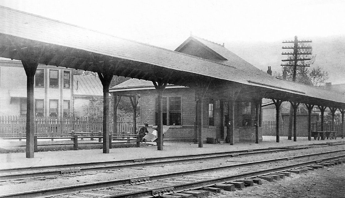
Notes About Existing Stations... Cincinnati (Union Station) - Also used by Amtrak. On National Register of Historic Places. Cincinnati (Southern) - The tracks leading to the station are gone but the yard behind the station is still active. JW Express Inc. owns it. This was known as the L&N's Brighton Freight Station. Cincinnati (B&O) - On NRHP. The building is now known as "Longworth Hall" and has artists' offices, restaurants, and sales offices as occupants. Interior has been extensively remodeled, but exterior (except for entrance doors) has remained nearly original. Cincinnati (CCC&St.L) - Houses Flatlow-Riley Co., produce distributor Elmwood Place (CCC&St.L) - Moved in the 1960s to Cordes Lumber Yard in Carthage. Glendale (CH&D) - Built in 1880 after original station burned. This station has been restored. Here is an old photo. Milford (Little Miami, later PCC&St.L) - This station may or may not be the original Little Miami RR station (there is no reason to doubt that it is), but it does sit on the original foundation and this is marked as the original location of that station on maps. The PCC&St.L also had a freight station at this location a few yards to the south, but it was gone by 1933. The building was used as a business, but then coverted into a trailhead along the Little Miami bike trail. Mt. Washington (CG&P) - American Legion Post #484. The station replaced a wooden structure when the railroad electrified the route in 1902. Steam, and electrics used the line together until 1915. After a wreck east of Amelia, steam was not allowed on the route any more. It remained electric until the line's demise in 1936. The Cincinnati Water Works used the first 2 miles of the line until the early 30s, then sold the last of the line for scrap. Norwood (CL&N) - This was also known as the Hopkins Avenue Station. Before this station was erected there was only an open platform here. Silverton (Replica) - This is a replica of an original CL&N structure. South Hartwell (CCC&St.L) - Station was moved around 1910 to its current location by the Hartwell Athletic Club. Its original location was at the intersection of Anthony Wayne Avenue and Parkway Avenue at approximatly GPS: 39.207907, -84.465749. The date of the station being moved seems to coincide with the new brick station that was built at Hartwell (and the name was then changed to just "Hartwell"). Winton Place (M&C) - Moved. Now has a sign "Chester Park" on it. Chester Park was the original name of Winton Place. The station was closed in 1969. It served four railroads at the time of its closing: B&O, C&O, N&W and Penn-Central (Cincinnati Enquirer, 5-10-1969). According to some sources, the station was built in 1872. Woodlawn (CH&D) - Moved about 300 feet from trackside in the 1950s. It was originally on the south side of the road on the east side of the tracks. Has a small addition to the rear of the building. |
||||||||