 COUNTY COUNTY
|
|
||||||||
| EXISTING STATIONS | ||||||||
|---|---|---|---|---|---|---|---|---|
| Station Name |
Original Railroad | Current Location |
Type | Current Use |
Date Built |
Track Status |
Building Material |
More Info |
| Alledonia |
 |
Crabapple Road at Pugh Ridge Road (GPS: 39.899184, -80.969514) |
C | Unknown | 1880 | Gone | Wood | |
| Armstrongs Mills |
|
South side of SR 148 at the intersection With Armstrong-Centerville Road. | P | Unknown | ???? | Gone | Brick |
|
| Armstrongs Mills |
|
South side of SR 148 at the intersection With Armstrong-Centerville Road. | F | Unknown | ???? | Gone | Wood | |
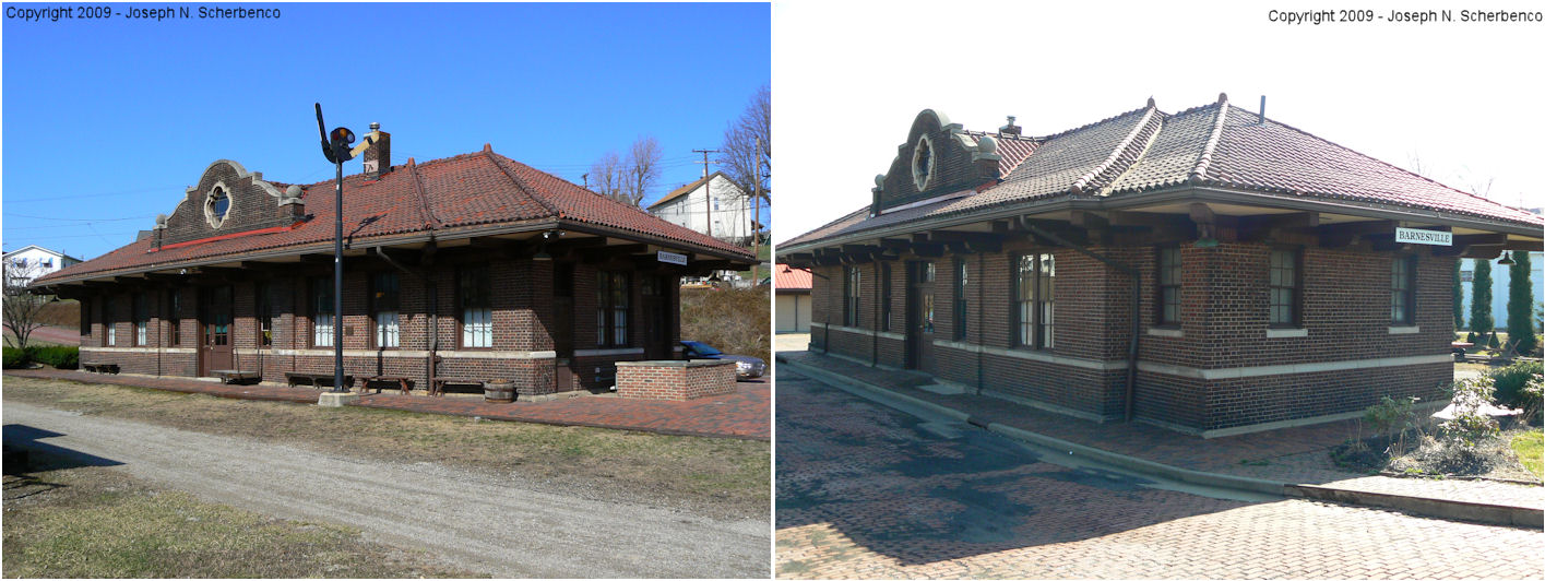
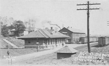
| Barnesville |
 |
300 East Church Street | P | Museum | 1917 | Gone | Brick |
|
| Bellaire |
 |
3103 Union Street (GPS: 40.012874, -80.742720) |
P | Restaurant | ???? | ???? | Brick |
|
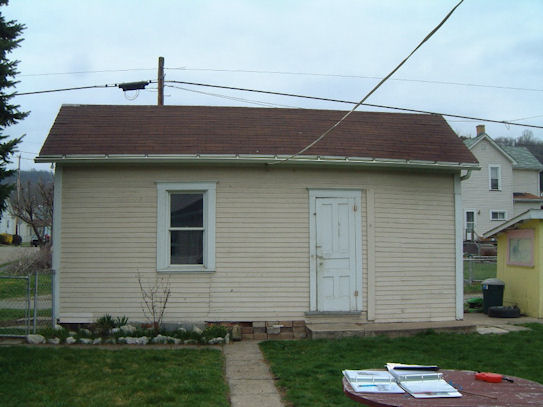
| Jacobsburg |
 |
49384 Jacobsburg Key Road | C | Residence | 1885 | Gone | Wood |
|
| Lashley (Ambler) |
|
Wegee Road (GPS: 39.958275, -80.787222) |
P | Residence | ???? | Gone | Wood |
|
| Mapleton |
|
55209 Wegee Road | P | Business | ???? | Gone | Wood |
|
| St. Clairsville |
 |
East side of South Sugar Street at St. Clair Street (GPS: 40.077646, -80.897193) |
C | Vacant | ???? | Gone | Wood |
|
| St. Clairsville |
 |
Station Street (GPS: 40.082289, -80.909301) |
F | Vacant | ???? | Gone | Metal |
|
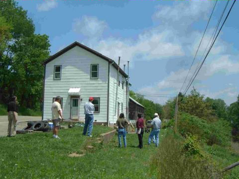
| Shadyside (Riverview) |
|
3801/3803 Central Avenue at 38th Street (GPS: 39.973181, -80.747289) |
P | Residence | ???? | Gone | Wood | |
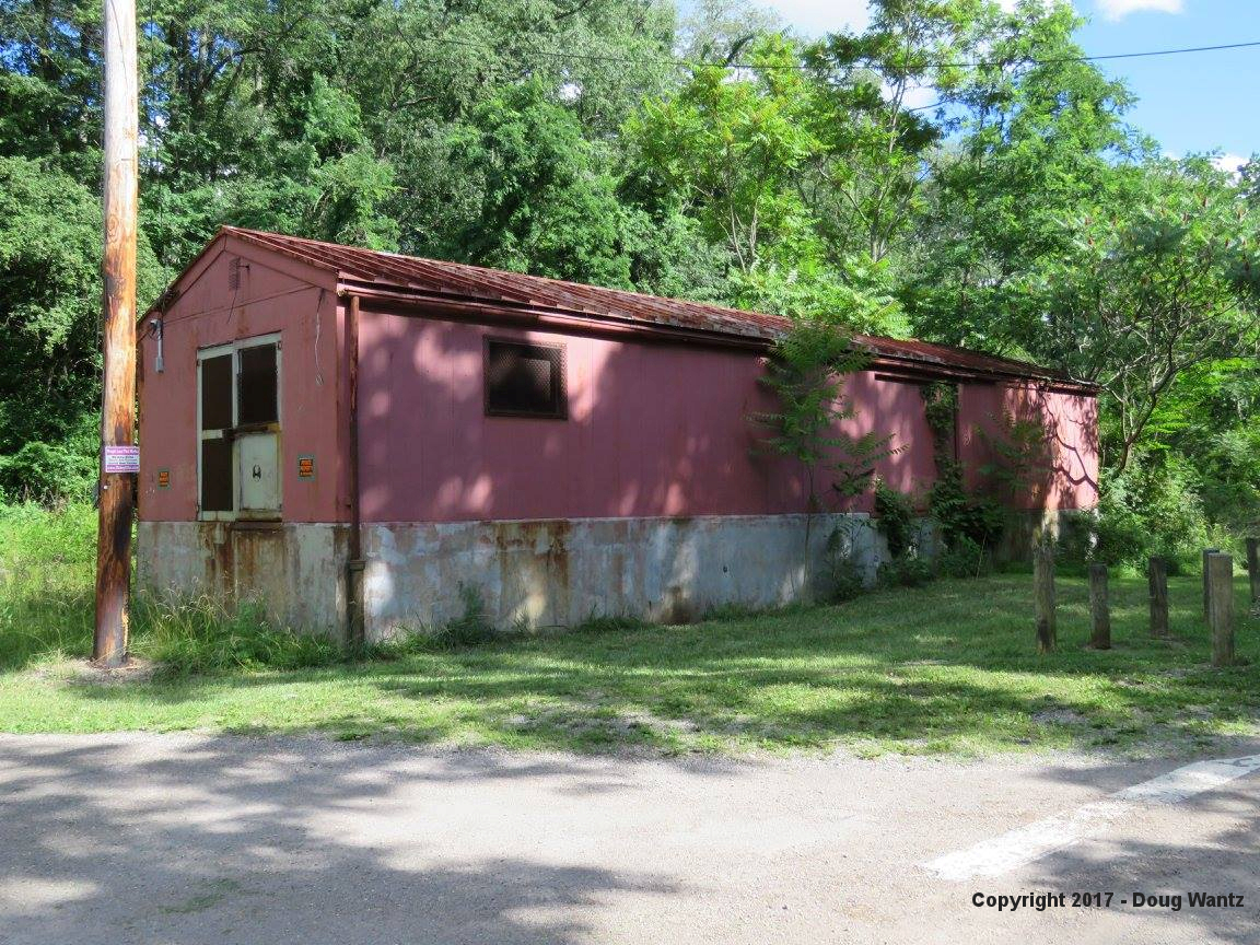
| Shadyside |
|
Along an alley behind a house on East 37th Street between Lincoln and Highland. | F | Garage | ???? | None | Wood |
|
| STATIONS OF THE PAST | ||||||||
| Station Name |
Original Railroad |
Notes | ||||||
| Ambler |
|
|||||||
| Aults |
 |
A boxcar was placed here in 1908 to serve as a station on this former Pittsburgh, Ohio Valley & Cincinnati RR line. A station is shown here on the 1923 PRR List of Stations & Sidings. | ||||||
| Avondale (Pultney) |
|
A general store served as the station here. It was built in 1881. | ||||||
| Avondale |
|
A station is shown here on the 1923 PRR List of Stations & Sidings. | ||||||
| Baileys Mills |
|
|||||||
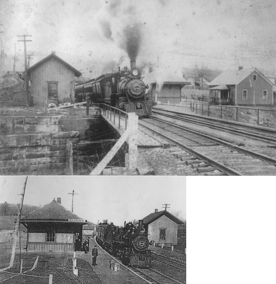
| Bannock (Bruce) |
|
The photo shows the original CL&W depot with the new 1905-model station across the tracks. | ||||||
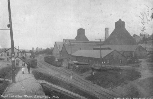
| Barnesville |
|
This the pre-1917 B&O station which sat across the tracks from the glass factory in approximately the same place as the existing station (near the intersection of Church and Mulberry Streets. | ||||||
| Barnesville |
|
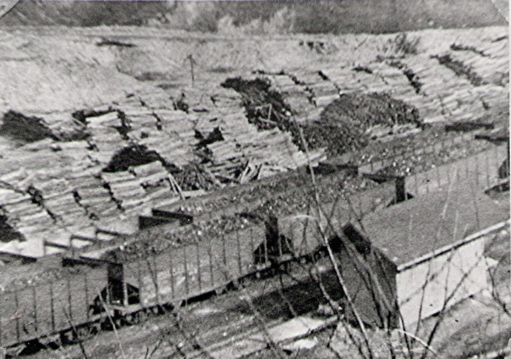
There was a freight station here that was demolished in 1962. | ||||||
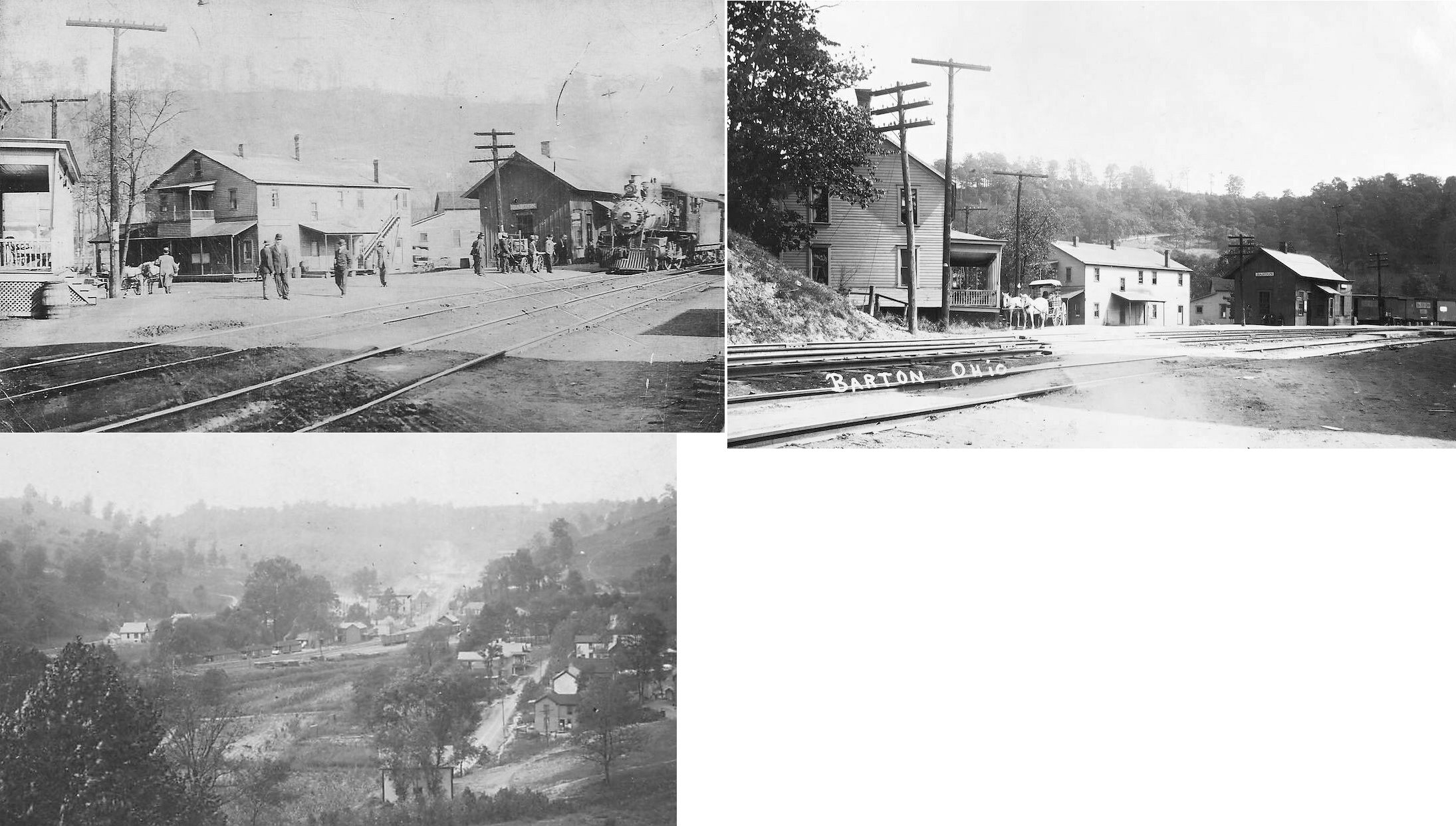
| Barton |
|
This station was on the east side of Colerain Pike (formerly called "A" Street). It was across the street from a hotel and next door to the Y&O Coal Company Store on the north side of the tracks. | ||||||
| Beckett |
|
A shelter-type station was built here in 1916. | ||||||
| Bellaire |
|
Harry Neff writes... This
station sat at the corner of 31st and Union Streets and was probably built
in 1871 as the viaduct was completed in 1870, and the original bridge in
1871. At that time, a new station would have been needed, because the
tracks would have been probably 40 or 50 feet above the level of the old
station. The "new" station, was further from the river bank, and located
on the east side of Union Street. The restaurant that is called Union
Street Station today is on the west side of Union Street, at ground
level. There was another B&O passenger station for a couple of years near the end of B&O passenger service in Bellaire. There was a signal tower a couple of blocks west of the passenger station, and some time in the late 1950's, the B&O closed the passenger station and passengers boarded the train at the signal tower. It almost shouldn't count as a railroad station, because by that time, my grandfather was the only person I ever saw getting off the train there. The end was very near. -Harry Neff |
||||||
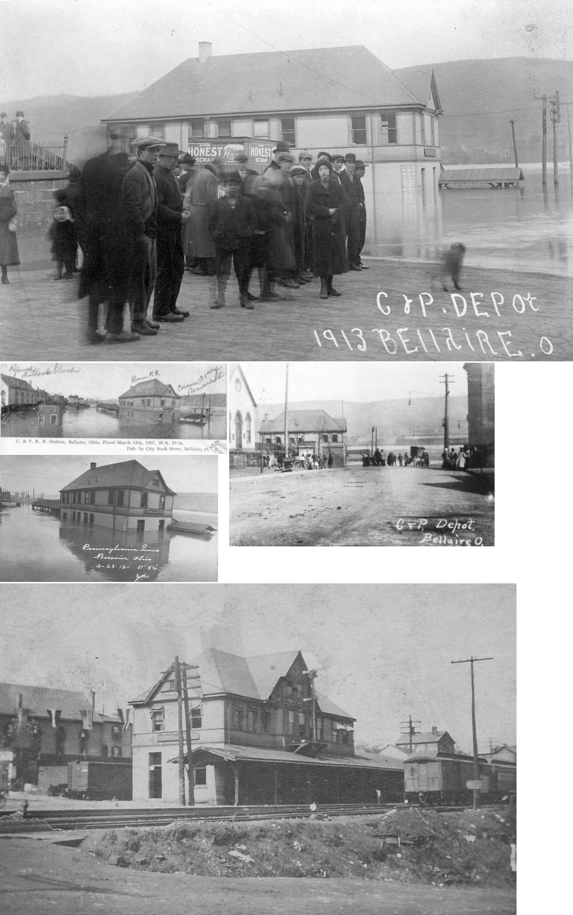
| Bellaire |
 |
There was a station here as early as 1857 when the line opened for service between Steubenville and Bellaire. This one-story, wood-frame station sat at Union Street & Central Avenue (34th Street) at GPS: 40.015998, -80.741212. It burned down on November 19, 1887. | ||||||
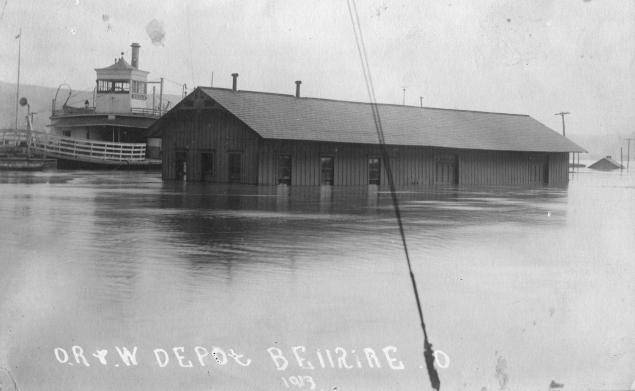
| Bellaire |
AND |
This station sat at Union Street & Central Avenue (34th Street) at GPS: 40.015998, -80.741212. The German Reformed Church can also be seen in the first photograph. According to PRR vaulation records, the station was built in 1888 to replace the station listed above that burned. It opened in early 1889. The OR&W also used this station beginning in 1921 until the railroad's demise. It was torn down in 1961. | ||||||
| Bellaire |
|
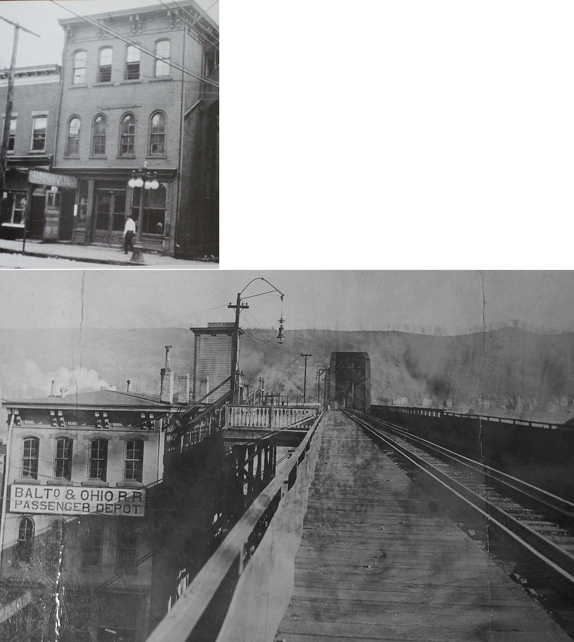
According to old Sanborn Fire Insurance maps, there was a frame pier attached to the B&O passenger station that held the platform and led to the tracks on the bridge. The passenger station was on the third floor. The building also housed the express office and telegraph office. The B&O passenger station was torn down around 2000 for the SR 7 bypass. | ||||||
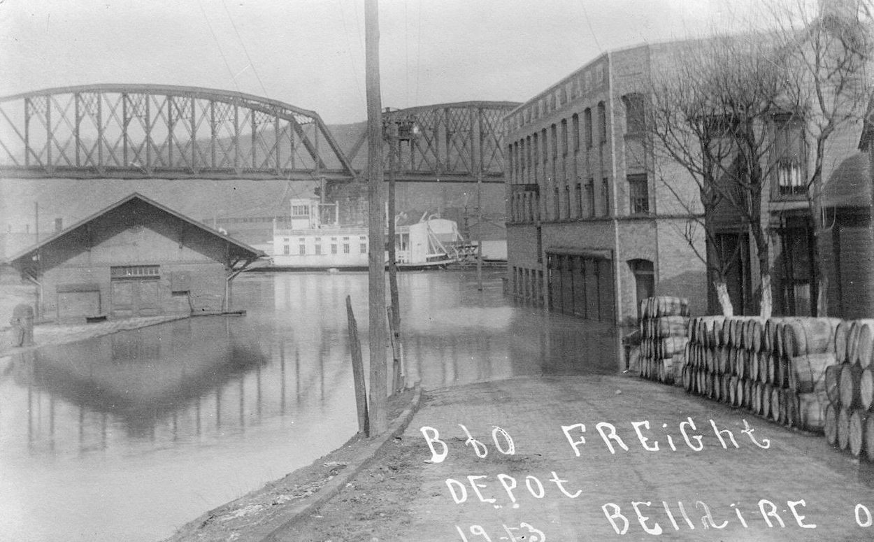
| Bellaire |
|
The B&O freight station was located near the intersection of Union and Crescent Streets near the river. It was about 100 feet southeast of the BZ&C depot and B&O viaduct. | ||||||
| Bellaire |
|
The Bellaire, Zanesville & Cincinnati (name changed to Ohio River & Western in 1902) had its station below and just south of the B&O viaduct along the river at the end of 31st Street. The B&O built this station for the BZ&C in 1883 along with a bridge from the station to the B&O station for transfers. | ||||||
| Belmont |
|
A new station was built here in 1905. | ||||||
| Belmont County Children's home |
|
According to maps from 1888, the Children's Home had it's own station. The home was located NE of Barnesville. Specifically, it was in the SE corner of Section 10, Warren Township. | ||||||
| Belmont Park |
|
There was only a passenger platform here according to valuation records for the POV&C RR (Pittsburgh, Ohio Valley & Cincinnati). A station is shown here on the 1923 PRR List of Stations & Sidings. | ||||||
| Bethesda | |
This station was demolished in a derailment of a through train on Dec. 20, 1923. The derailment was caused by a broken bolt on the track (New Philadelphia Daily Times, Dec. 20, 1923). | ||||||
| BethEl |
|
See listing for Key below. | ||||||
| Blaine (Pasco) |
|
This town is now known as Blaine, but was formerly called "Pasco" (perhaps due to there being a Pasco in Shelby County as well). The station was on Belmont County Road 10 (Blaine-Barton Road) between US-40 and Blaine-Chermont Road. It appears there was a standard station here as well as a converted passenger car perhaps used as a freight station. | ||||||
| Bridgeport |
 |
Photo shows a way station somewhere near Bridgeport. Most likely PRR or B&O. Does anyone have information about what RR this station belonged to? Perhaps someone can identify the locomotive. | ||||||
| Bridgeport |
|
The first passenger station here sat at the NE corner of Morgan and Howard Streets. It is shown on maps from 1888, but was gone by 1897. It was on a transfer track. | ||||||
| Bridgeport |
|
Built sometime between 1889-1897, the second passenger station sat on National Road (later US 40) just south of the road bridge to Wheeling. Just south of the station, in the old days, was a covered railroad bridge over Wheeling Creek. | ||||||
| Bridgeport |
|
The CL&W freight station was on the west side of Morgan Street (S. Lincoln Avenue) north of Howard Street at GPS: 40.070476, -80.741453. | ||||||
| Bridgeport |
|
This newer freight station was built around 1905. | ||||||
| Bridgeport |
|
The original station here likely opened when the line did in 1857. According to the Belmont Chronicle of May 2, 1889, the station was torn down with the intent to reassemble it for "temporary use at a station near Cleveland." | ||||||
| Bridgeport |
|
The C&P passenger station sat just north of the road bridge to Wheeling. According to PRR valuation records, the station was built in 1886. | ||||||
| Bridgeport |
|
The freight station was across the tracks from the passenger station. It bordered Bank Street. According to PRR valuation records, the station was built in 1855 (so this may have been the original station here repurposed as a freight-only station). | ||||||
| Burlington |
|
|||||||
| Burtons |
|
|||||||
| Captina |
|
There was a combination station here that was built in 1887. This location was originally known as Rock Valley. | ||||||
| Clevenger |
|
|||||||
| Crabapple |
|
This station sat on the west side of the tracks near the junction of TWP Road 103 (Crabapple Lane) and TWP Road 105. | ||||||
| Crescent |
|
|||||||
| Crow |
|
A shelter-type station was built here in 1916. Hardly anyone lived near this station. When the RR originally bought land for the right-of-way from the Crow family, one provision was that there would be a station here. | ||||||
| Dille |
|
A 12'x19' passenger shelter was built here in 1898 according to valuation records from 1929. A station is shown here on the 1923 PRR List of Stations & Sidings. | ||||||
| Dorsey |
|
A shelter-type station was built here in 1916. | ||||||
| Dunfee |
|
A shelter-type station was built here in 1916 and an old boxcar was used as a freight shed. | ||||||
| Echo |
|
|||||||
| Fairmount |
|
|||||||
| Fairpoint |
|
This station burned down sometime in the early 1900s. | ||||||
| Fairpoint |
|
This was the replacement station for the one listed above. It was built in 1905. | ||||||
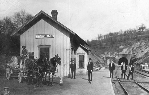
| Flushing |
|
This was the first station at Flushing, built by the CL&W. It was at the south end of Depot Street. | ||||||
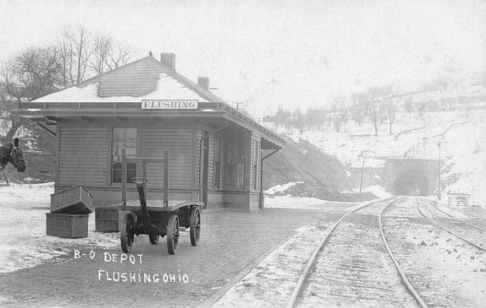
| Flushing |
|
This was the second station built at Flushing in 1905. This B&O designed station replaced the old CL&W station (see above). | ||||||
| Franklin |
|
|||||||
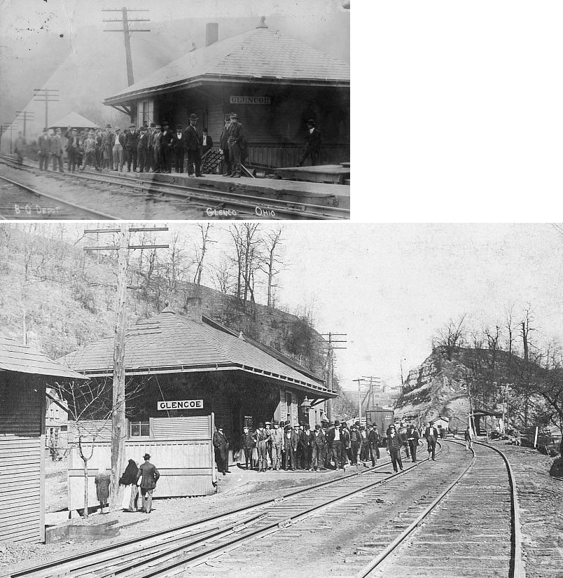
| Glencoe |
|
In 1888 this station was on Main Street just NW of the trestle over the creek. It was on the SW side of the tracks. L.B. Potts was the B&O agent here at that time. A new station was built here in 1905. | ||||||
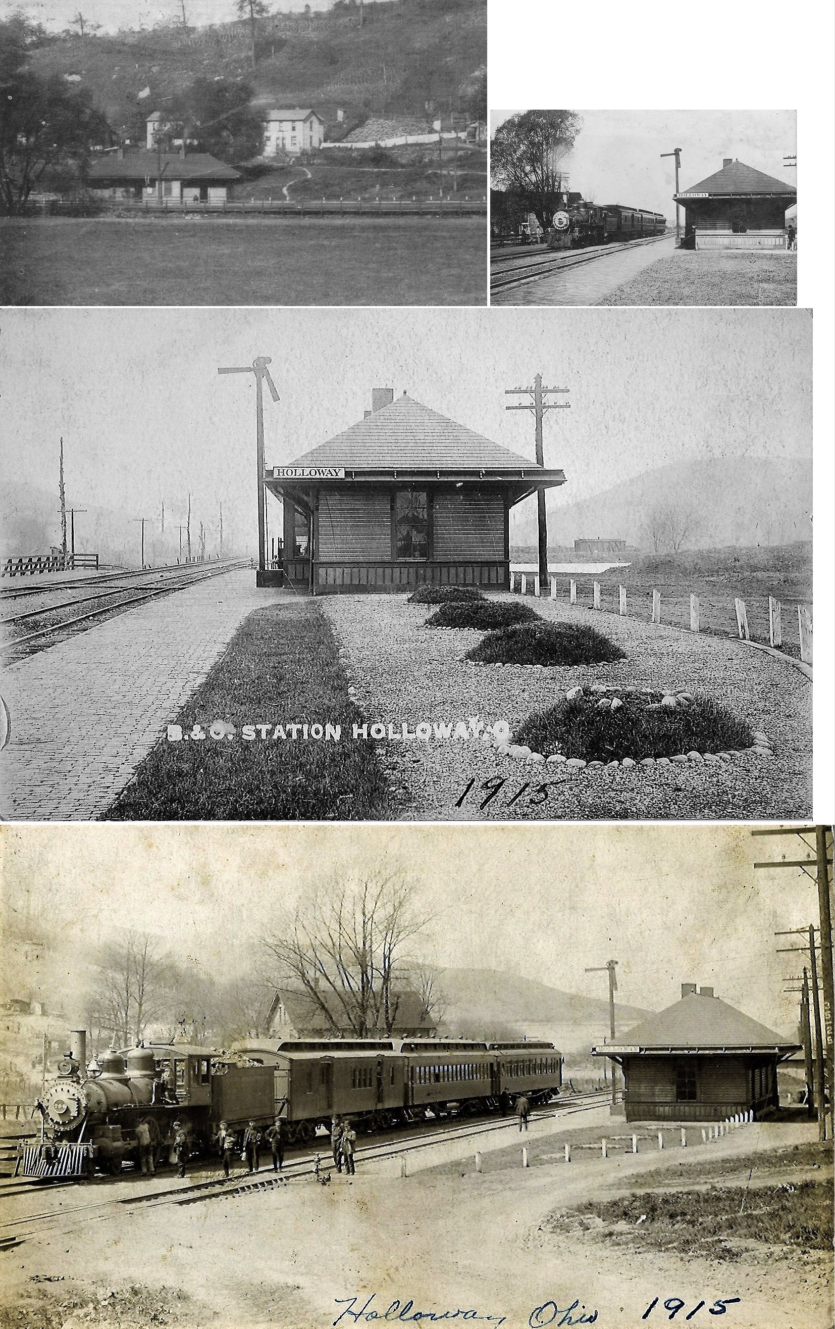
| Holloway |
|
The first station here was built around 1883. The station here was demolished on Dec. 10, 1902 when a runaway train collided with another train parked at the depot. The headline in the newspaper (Cincinnati Enquirer, Dec. 11, 1902) says the depot was demolished, but the text of the article says, "...the two trains plowed through the station building and the telegraph office, almost demolishing both," so it is not clear if the depot was salvaged or razed following the accident. | ||||||
| Holloway |
|
This was a standard B&O station built in 1905. A number of these stations (including Kent, Newton Falls, Wayland, Charleston, Lafferty and Fairpoint) were all built by the firm of Holbert & McSpedden of Fairmont, West Virginia. | ||||||
| Irvin |
|
|||||||
| Johnson |
|
A 15.5'x19.5' type I passenger station was built here in 1913 according to valuation records for the POV&C (Pittsburgh, Ohio Valley & Cincinnati). A station is shown here on the 1923 PRR List of Stations & Sidings. | ||||||
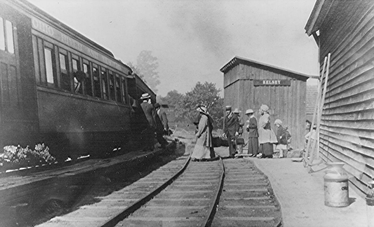
| Kelsey |
|
This station was located at 48809 Centerville Jacobsburg Road at approximately GPS: 39.963430, -80.919728. It was two-story combination station that was built in 1880 as a general store with the station sign on a shed next to the tracks. It burned down around 2004. | ||||||
| Key (Bethel) |
|
This combination station was located at 61698 Jacobsburg Key Road just west of the Highmart store. Built in 1879, it was a 2-story wood structure that was in later years covered in "Insulbrick" siding. It was almost identical to the one still standing at Jacobsburg. It was purposely burned in 1992 as it had become uninhabitable due to termite damage. A trailer is currently siting on the site. This was a general store/residence that served as the station here. This location was formerly known as Bethel. | ||||||
| Lafferty |
|
|||||||
| Lafferty |
|
A newer 1905 model station was built here to replace the earlier CL&W station. | ||||||
| Lewis Mills |
|
|||||||
| Marbletown |
|
|||||||
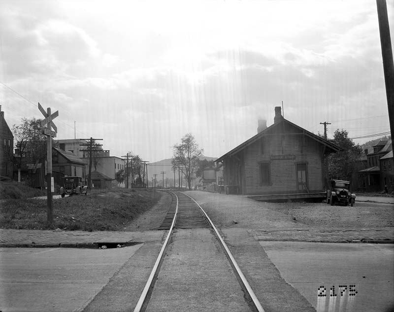
| Martins Ferry |
|
The original wood-frame station here burned down in in August 1886 while the new brick station (listed below) was already under construction (Belmont Chronicle, 8-12-1886). | ||||||
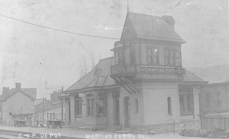
| Martins Ferry |
|
This brick passenger station was at the corner of Walnut & 2nd Streets on the SE side of the tracks at GPS: 40.094216, -80.723059. According to PRR valuation records, the station was built in 1886. The brick freight house, built in 1885, was on 2nd Street near Wood Street near the connection with the B&O. | ||||||
| Martins Ferry |
|
The original passenger and freight stations were on the east side of 1st Street just south of Penn Street. The original passenger station was vacant in 1900 and torn down by 1908, although the freight station remained for many years. Later Sanborn maps of Martin's Ferry do not show a B&O passenger station, although it seems likely that there was one. Does anyone know where it was located or if passenger operations were handled out of the freight station as well? | ||||||
| Martins Ferry (Hanover Street) |
|
The passenger and freight stations were next to each other on 6th Street (now Zane Highway) between Walnut and Hanover Streets. On the 1908 Sanborn map the original freight station is marked "damaged by fire" and it was replaced soon after. | ||||||
| Martins Ferry | |
This photo was identified as a station, but needs verification and location. It would seem that if the W&LE named their other station "Hanover Street," that implies there was another station in town somewhere. | ||||||
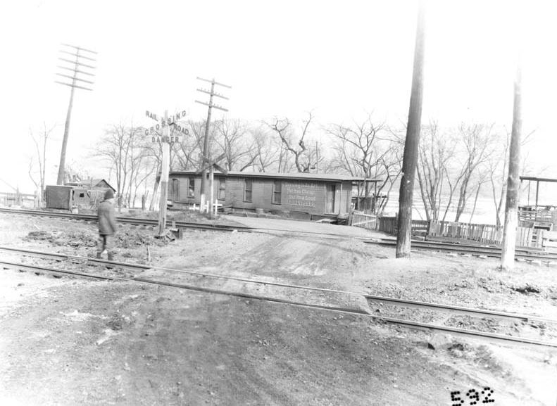
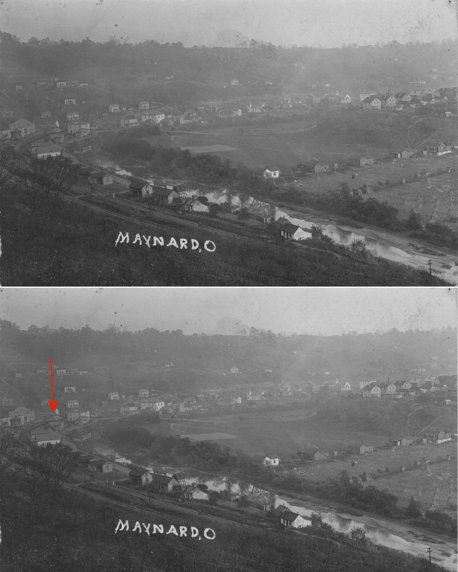
| Maynard |
|
This station was near the intersection of Bright Road and CR 56. A new station was built here by the B&O in 1905. | ||||||
| Moore |
|
A shelter-type station was built here in 1916. | ||||||
| Narrows Run |
|
There was only a passenger platform here according to valuation records for the POV&C RR (Pittsburgh, Ohio Valley & Cincinnati). A station is shown here on the 1923 PRR List of Stations & Sidings. | ||||||
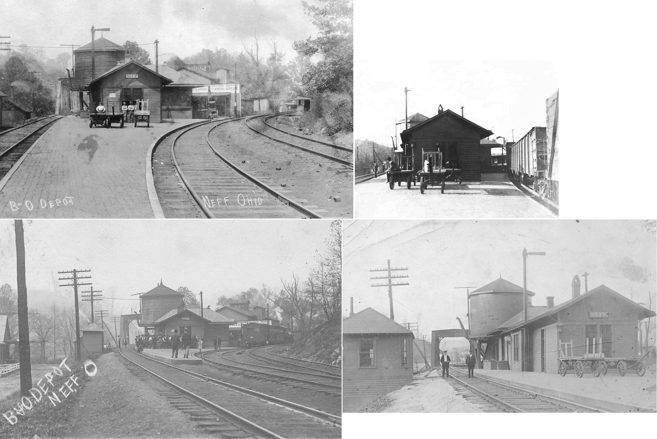
| Neffs |
|
The passenger station here was moved slightly in 1905 to allow for the construction of a new freight house. | ||||||
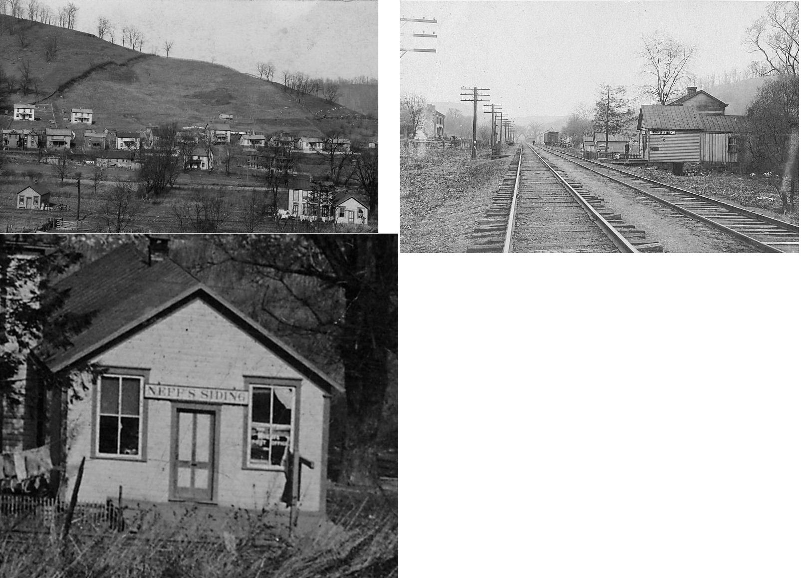
| Neffs Siding | |
|||||||
| Pasco |
|
See listing above for Blaine. | ||||||
| Pipe Creek (Ramsey) |
|
A shelter-type station was built here in 1916. | ||||||
| Pipe Creek |
|
A station is shown here on the 1923 PRR List of Stations & Sidings. | ||||||
| Powhatan Point |
|
The station was on Railroad Street (formerly 4th St.) about 100 yards southwest of the intersection with Taylor and Front Streets. It sat on the south side of the tracks. A station is shown here on the 1923 PRR List of Stations & Sidings. It was a half mile from the end of the Pittsburgh, Ohio Valley & Cincinnati Branch. | ||||||
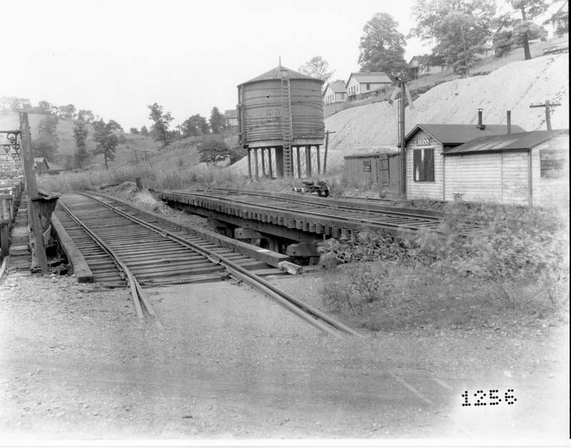
| Reiss (Trolls) |
|
This station likely served the New Pittsburgh Coal Company mines 82 and 83. | ||||||
| Rodifers |
|
A freight station was built here in 1903 according to valuation records. | ||||||
| Shadyside | |
In 1913 the railroad consturcted a 17'x19' passenger shelter here as well according to valuation records. | ||||||
| St. Clairsville |
 |
The St. Clairsville and Northern Railway connecting St. Clairsville to the CL&W in Barton was incorporated in 1882. The station was located on the west side of North Sugar Street just south of the intersection with Crescent Street. The St.C&N eventually became part of the B&O and as of 1946 the tracks and the station were gone. According to 1888 maps, the St.C&N came into town from the north and terminated at Newell Avenue just past the station. The B&O St. Clairsville branch came into town from the SE and terminated near the SW corner of the fairgrounds. | ||||||
| St. Clairsville Junction (Quincy) |
|
This station was just southeast of Neffs. The small village of Quincy is now part of Neffs. The station was on the east side of McMahon Creek where the two lines merged. This location is near what is today the northwest end of Talbot Road. | ||||||
| Stewarts |
|
A station is shown here on the 1923 PRR List of Stations & Sidings between Narrows Run and Powhatan. | ||||||
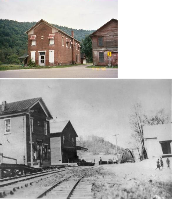
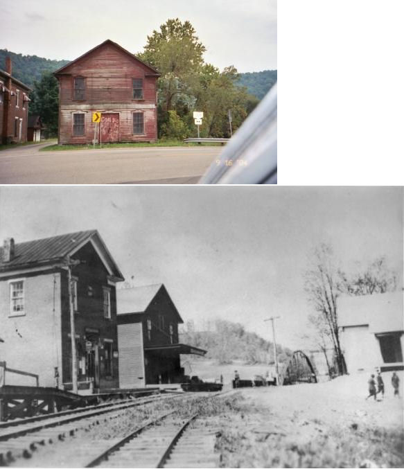
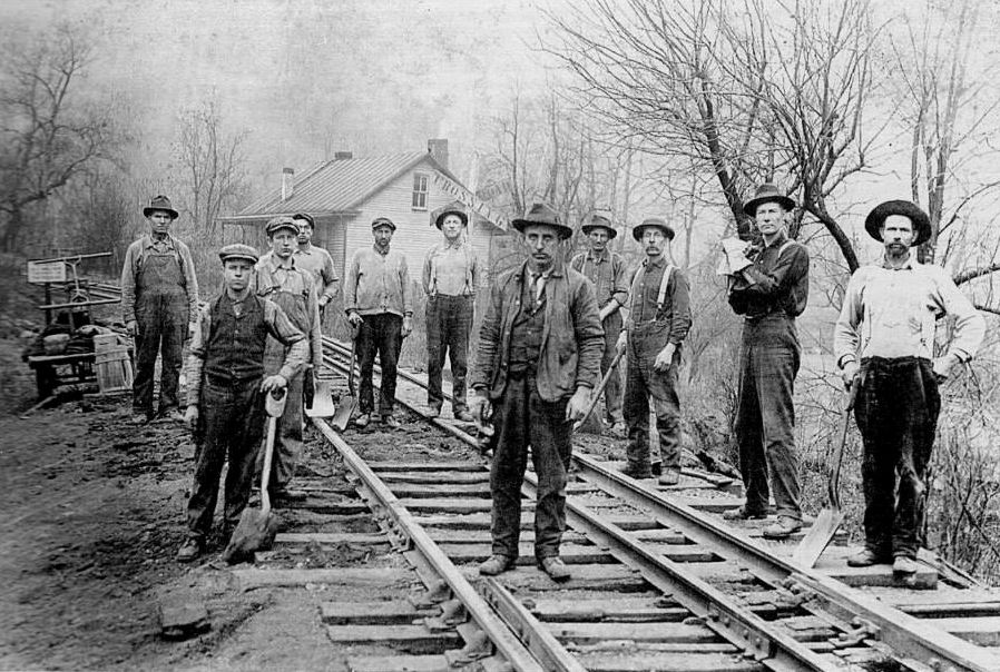
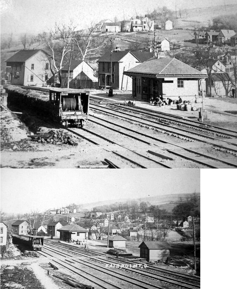
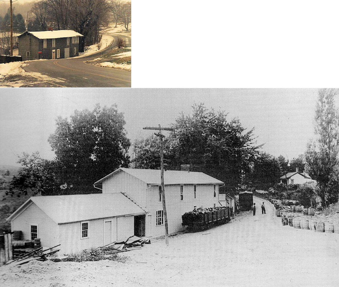
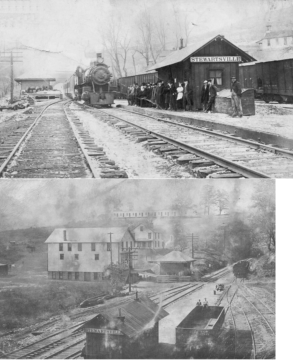
| Stewartsville |
|
A new freight house (shown in the background of the bottom photo) was added in 1905. | ||||||
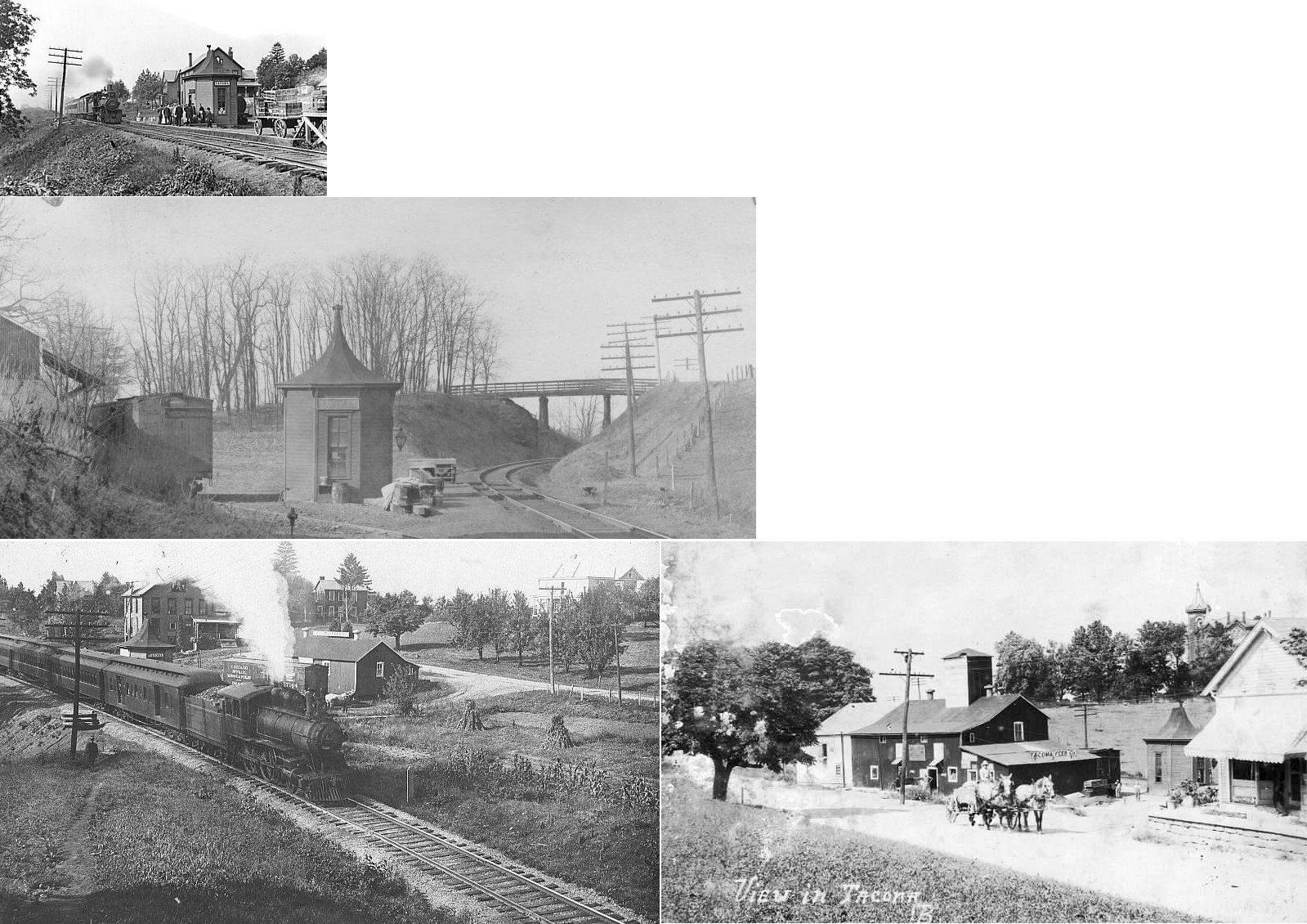
| Tacoma |
|
Passenger station. This station was razed in 1938 (Zanesville Signal, 8-20-1938). | ||||||
| Tacoma |
|
Freight station. | ||||||
|
Vallonia (Irwin) |
|
A shelter-type station was built here in 1916. A general store also served as a station here. The name was changed in 1899 from Irwin to Vallonia due to there being another Irwin in Ohio. | ||||||
| Warnock |
|
This station was built in 1905. | ||||||
| Webb |
|
This passenger shelter was built here in 1914 for the Webb Mine. It was washed away in a 1919 flood and replaced with the one listed below. | ||||||
| Webb |
|
This replacement shelter was built in 1919. | ||||||
| Wegee |
|
A general store with a platform served as the station here. It was built in 1880. | ||||||
| Wegee |
|
There was only a passenger platform at this location. A station is shown here on the 1923 PRR List of Stations & Sidings. | ||||||
| West Bridgeport |
|
|||||||
| West End |
|
There was only a passenger platform here according to valuation records for the POV&C RR (Pittsburgh, Ohio Valley & Cincinnati). It was built in 1911. A station is shown here on the 1923 PRR List of Stations & Sidings. | ||||||
| West Wheeling |
|
|||||||
| Wheeling Valley |
|
|||||||
| Workmans |
|
There was only a passenger platform here; no station building. A station is shown here on the 1923 PRR List of Stations & Sidings. | ||||||
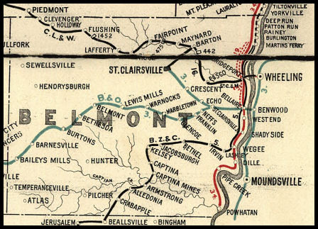
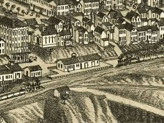
| 1898 BELMONT COUNTY RAILROAD MAP | ||||||||
 |
||||||||
|
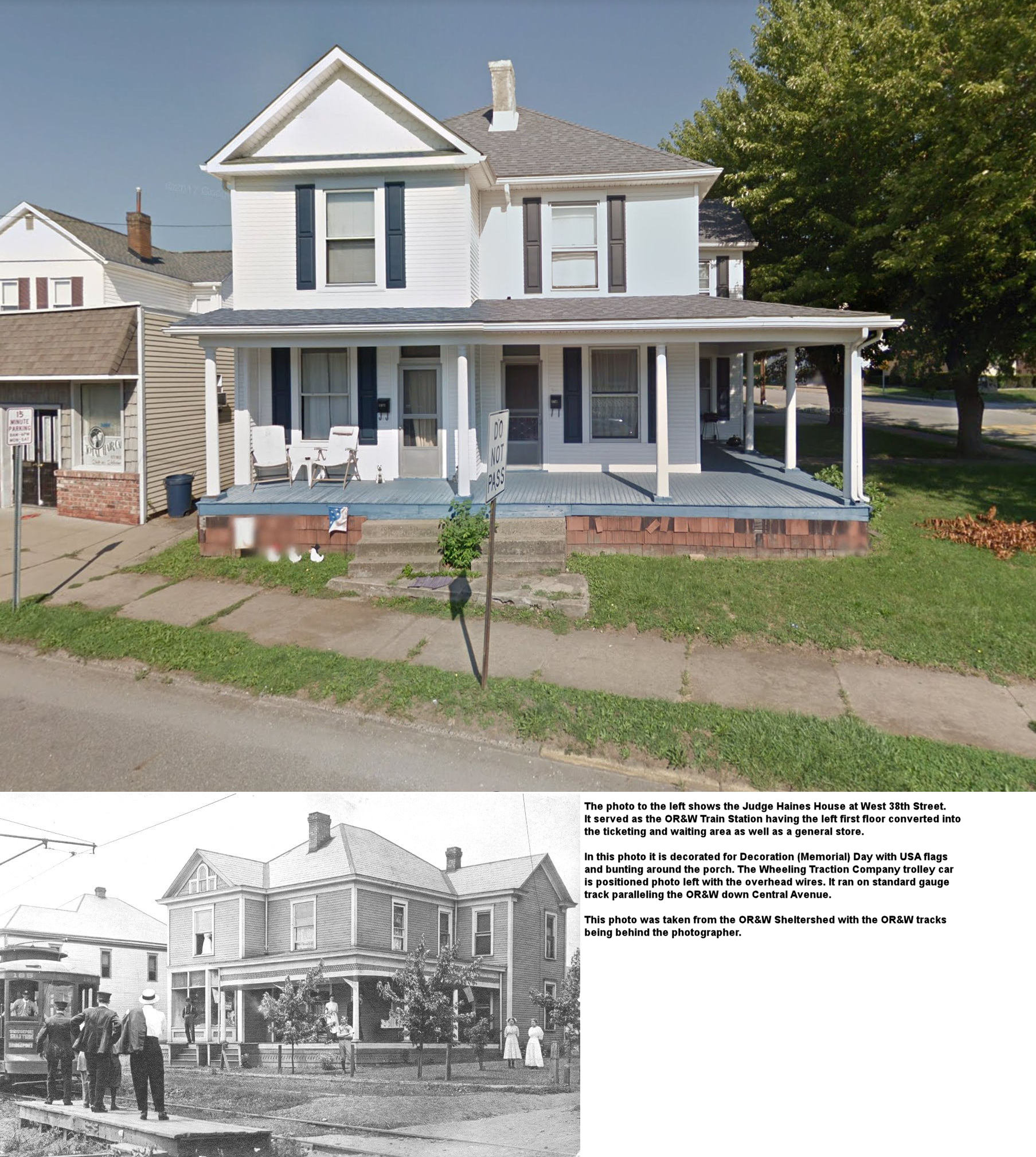
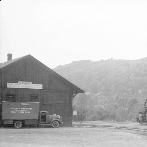
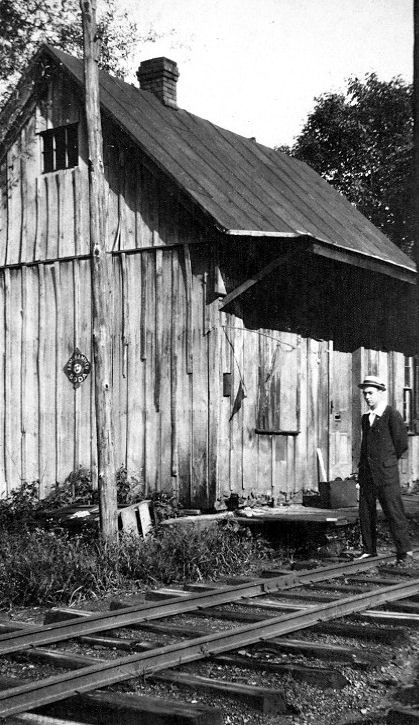
Notes About Existing Stations... Armstrongs Mills (Ohio River & Western) - The passenger station was originally a store owned by Alexander Armstrong. He donated the land for the railroad with the condition that the passenger station be based out of his store. The freight station was then added by the RR. Barnesville (B&O) - Restored! Tunnel under downtown nearby, caboose also on site. On National Register of Historic Places. Here is an old photo of the station. Bellaire (Central Ohio) - According to some sources, this station served the Central Ohio Railroad before it was bought by the B&O. This is not the same B&O station as listed in the Stations Of The Past section. Jacobsburg (BZ&C) - Like many of the stations that were on this line, this was a general store that served as the railroad station here. There are also a couple of freight buildings here and formerly had racks for the unloading of pipe used to support the oil & gas wells in the area from around 1890 to 1925. This was the second general store to be used as a station here. The original one was built in 1879. Jacobsburg was originally known as Grand View. Lashley (OR&W) - The name of this station was changed from Ambler to Lashley in 1883. This was a residence that also served as a station stop until 1899. Thereafter it was reduced in status to a flagstop and removed from the timetables. The house was raised atop a stone foundation to combat flodding from Wegee Creek. Mapleton (OR&W) - This building was a combination general store, residence and station. It was built in 1880. A shelter-type station was added here in 1916. It was most recently the Iron Eagle Inn (not sure if it is still open). The tracks ran behind the building. Shadyside (OR&W) - This station's original location was in the middle of Central Avenue at 40th street. The OR&W ran down the middle of Central Avenue. The building was auctioned and moved around 1931 when the RR closed. St. Clairsville (CL&W) - Owned by the school district. Exterior is rather intact, but inside has been gutted. Some of the brick platform is extant. According to 1888 maps, the B&O St. Clairsville Branch came into town from the SE along Aults Run and terminated near the SW corner of the fairgrounds. The station is of the earlier CL&W design. St. Clairsville (NKP) - This structure dates from the NKP era (post-1949) since other W&LE structures were replaced with Armco metal buildings around that time, but the W&LE may have originally had a freight house at the same location. This structure was on the Adena Branch of the W&LE (NKP). |
||||||||