 COUNTYCOUNTY
|
|
||||||||
| EXISTING STATIONS | ||||||||
|---|---|---|---|---|---|---|---|---|
| Station Name |
Original Railroad | Current Location |
Type | Date Built |
Current Use |
Track Status |
Building Material |
More Info |
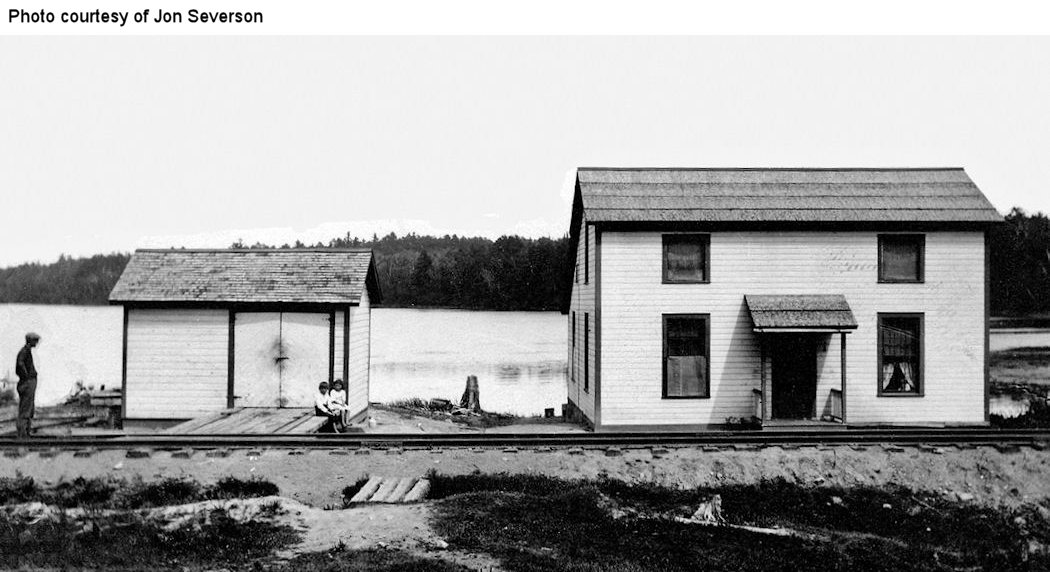
| Arbutus |
 |
9054 Highway 53, SE of Ash River Trail (GPS: 48.384701, -92.992849) |
C | ???? | Residence | None | Wood |
|
| Biwabik |
 |
6th Avenue South (GPS: 47.52637,-92.340855) |
C | ???? | Civic | In Use | Wood | |
|
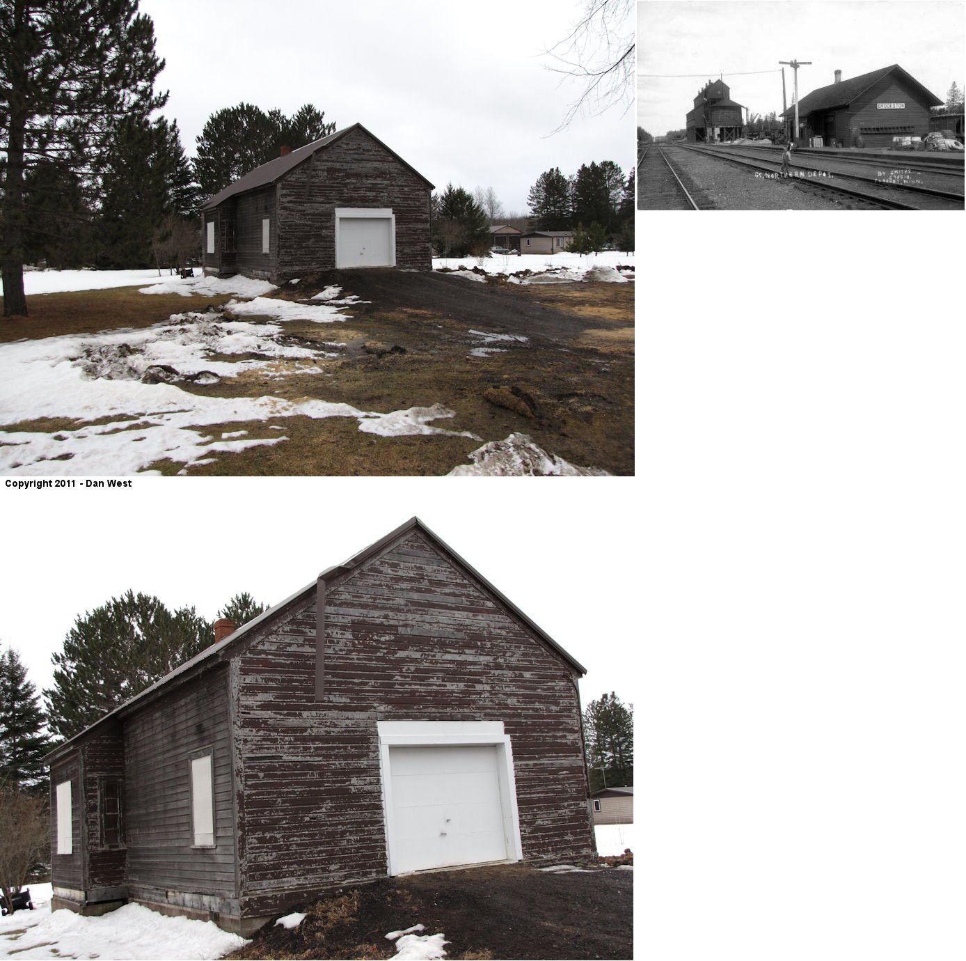
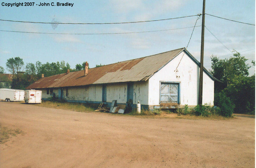
Brookston (Stoney Brook) |
 |
Corner of 3rd Avenue and 2nd Street South (GPS: 46.86559,-92.606683) |
C | 1902 | Storage | None | Wood |
|
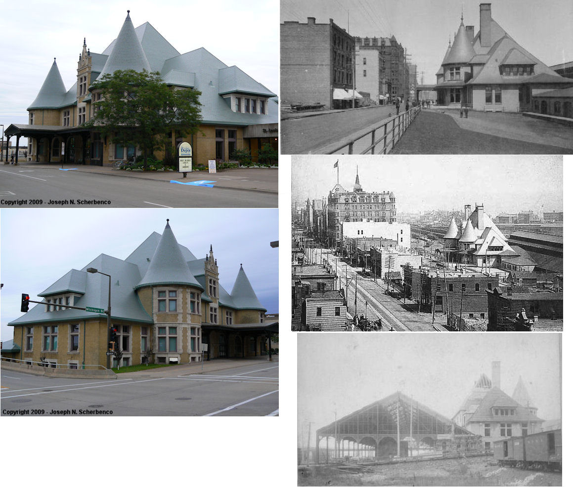
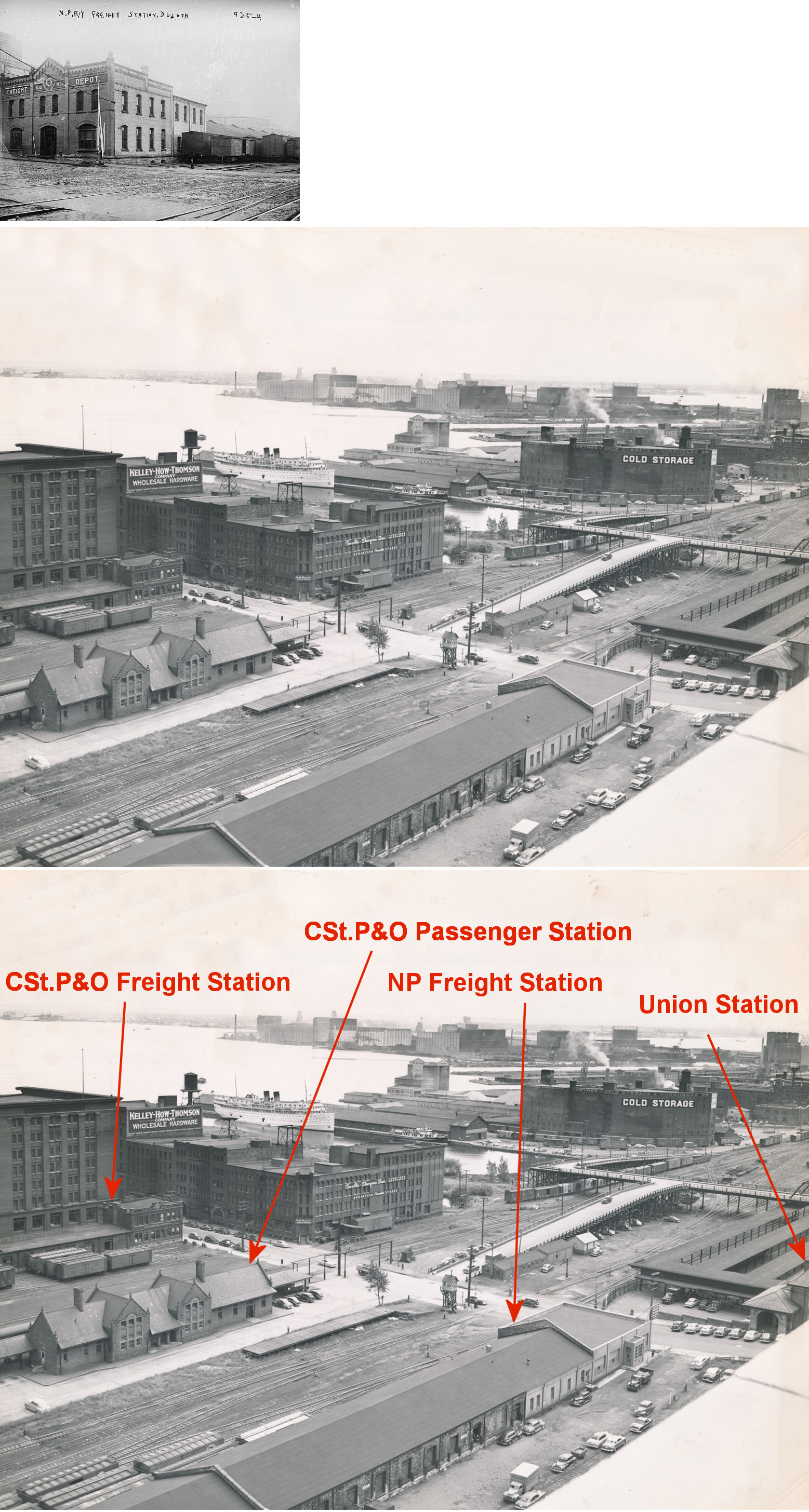
| Duluth |
 |
506 West Michigan Street (GPS: 46.781416, -92.104049) |
P | 1892 | Civic | In Use | Brick |
|
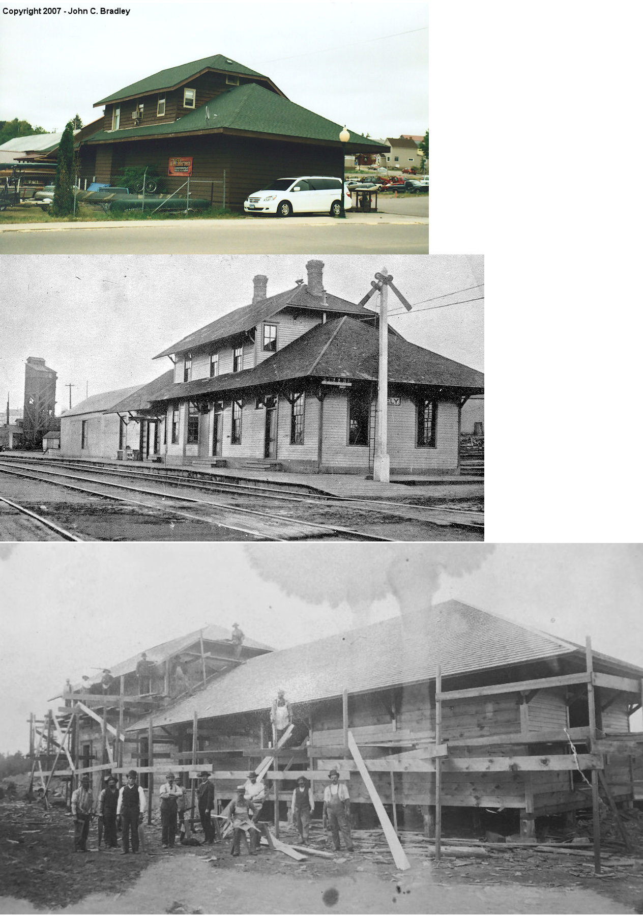
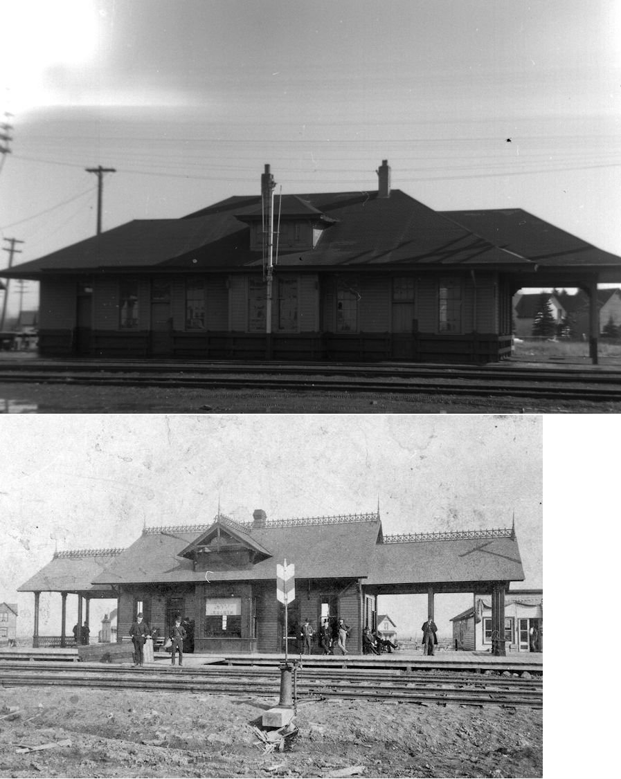
| Ely |
|
1 East Camp Street (GPS: 47.904651, -91.867158) |
C | ???? | Business | Gone | Wood | |
| Endion (Duluth) |
|
200 Lake Place Drive (GPS: 46.786344, -92.095154) |
P | 1899 | Business | None | Brick |
|
| Eveleth |
AND  |
300 Fayal Road (GPS: 47.460003, -92.541022) |
P | 1923 | Business | Gone | Stucco | |
| Eveleth |
|
Across the driveway south of the passenger station off Fayal Road (GPS: 47.459727, -92.540988) |
F | ???? | Storage | Gone | Wood | |
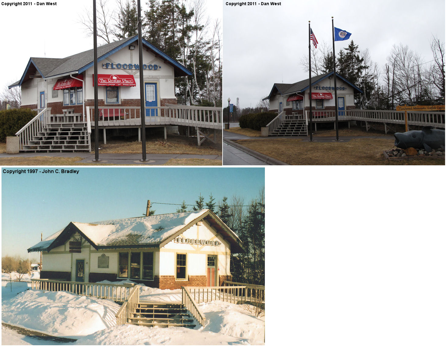
| Floodwood |
|
Visitor Center on NE side of US-2 between 8th and 9th Ave. (GPS: 46.925938,-92.917522) |
C | ???? | Civic | None | Brick/ Stucco |
|
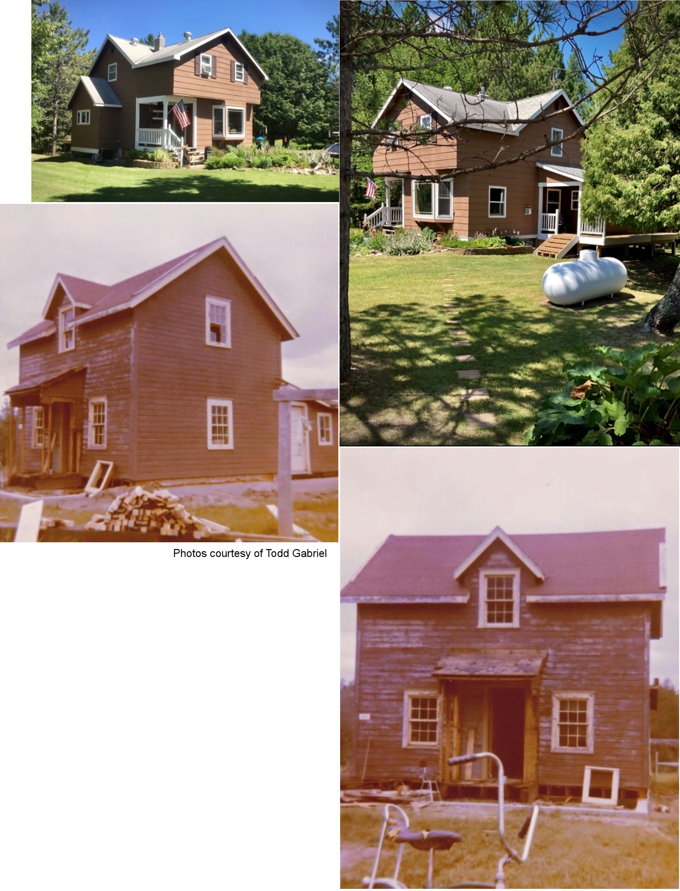
| Fond du lac |
 |
13308 West 3rd Street (GPS: 46.660516,-92.278263) |
C | 1870 | Residence | None | Wood |
|
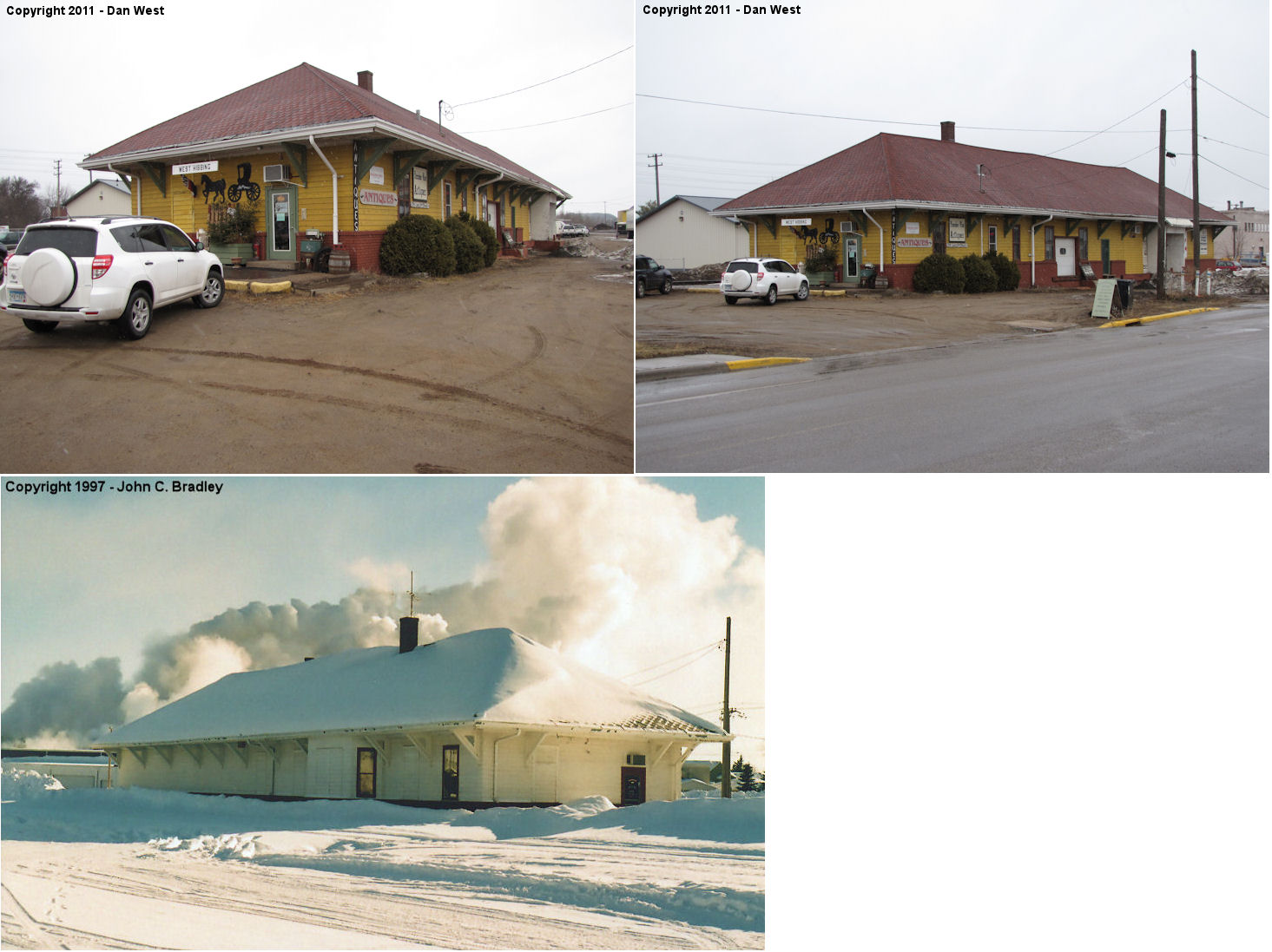
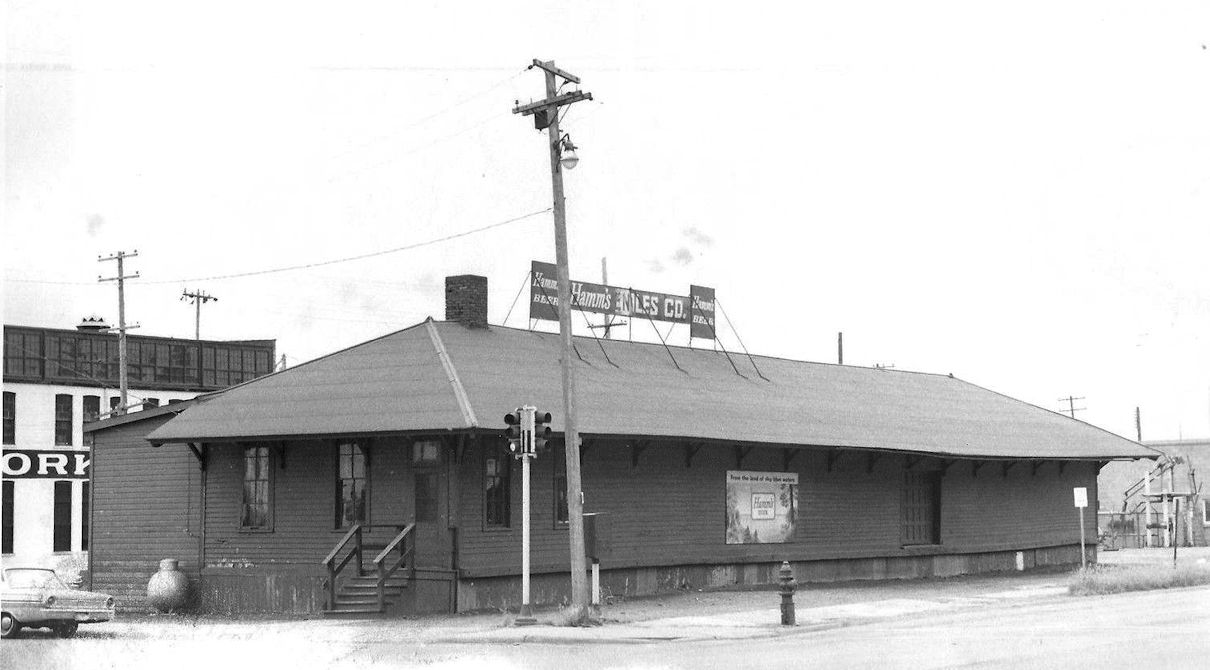
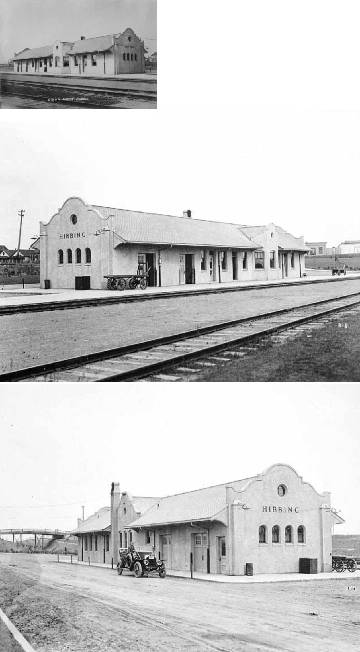
| Hibbing (South Hibbing) (Alice) |
|
19th Street (Industrial Street) and 4th Avenue East (GPS: 47.429437,-92.937942) |
P | 1903 | Business | In Use | Wood |
|
| Orr |
|
4557 US-53 (GPS: 48.054325, -92.831852) |
C | ???? | Business | None | Wood | |
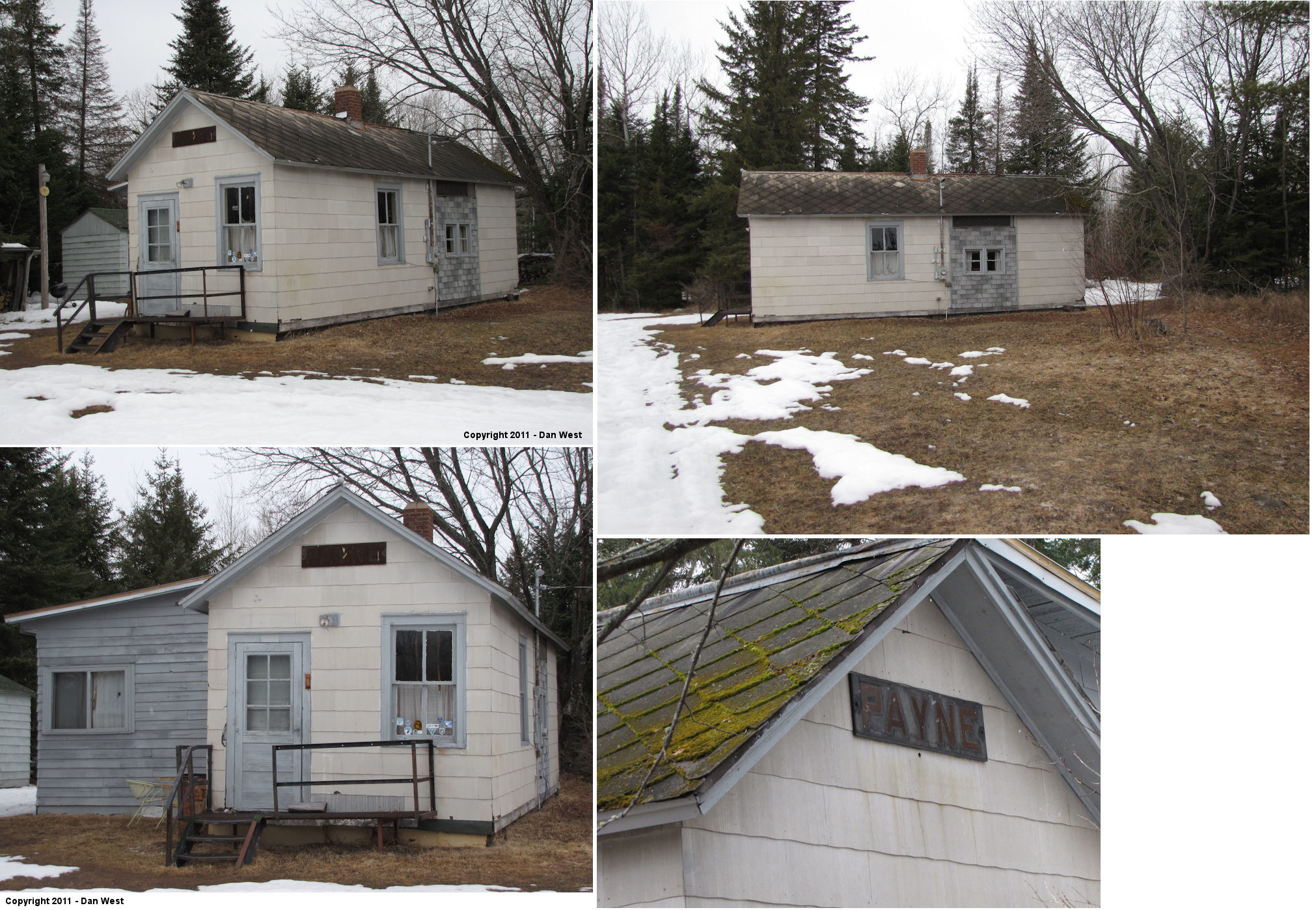
| Payne |
|
8061 County Road 7 (GPS: 47.095425,-92.600069) |
C | ???? | Residence | In Use | Wood | |
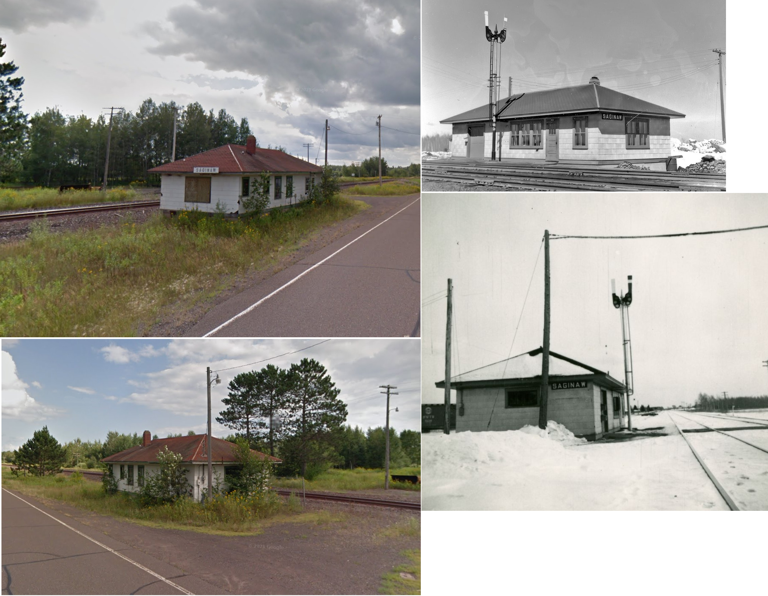
| Saginaw |
|
Saginaw Road (CR-46) SE of CR-875 (GPS: 46.85857,-92.44346) |
C | ???? | Railroad | In Use | Wood | |
| Taft |
|
One lot north of 6680 Munger-Shaw Road (GPS: 46.995175,-92.331687) |
C | ???? | Vacant | None | Wood |
|
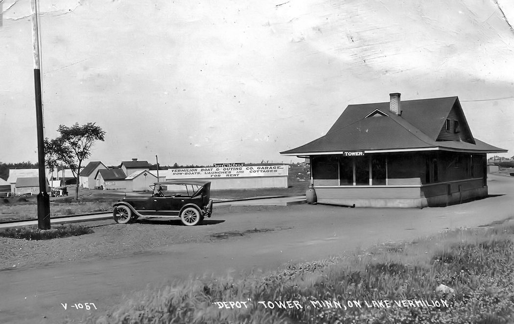
| Tower |
|
404 Pine Street (GPS: 47.804479, -92.278981) |
C | 1915 | Museum | Gone | Wood/ Stucco |
|
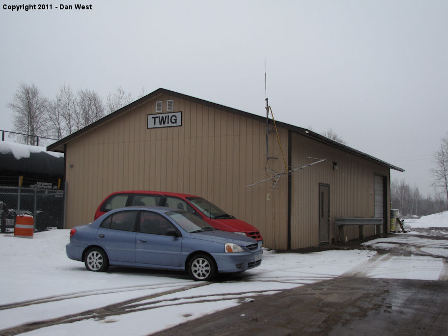
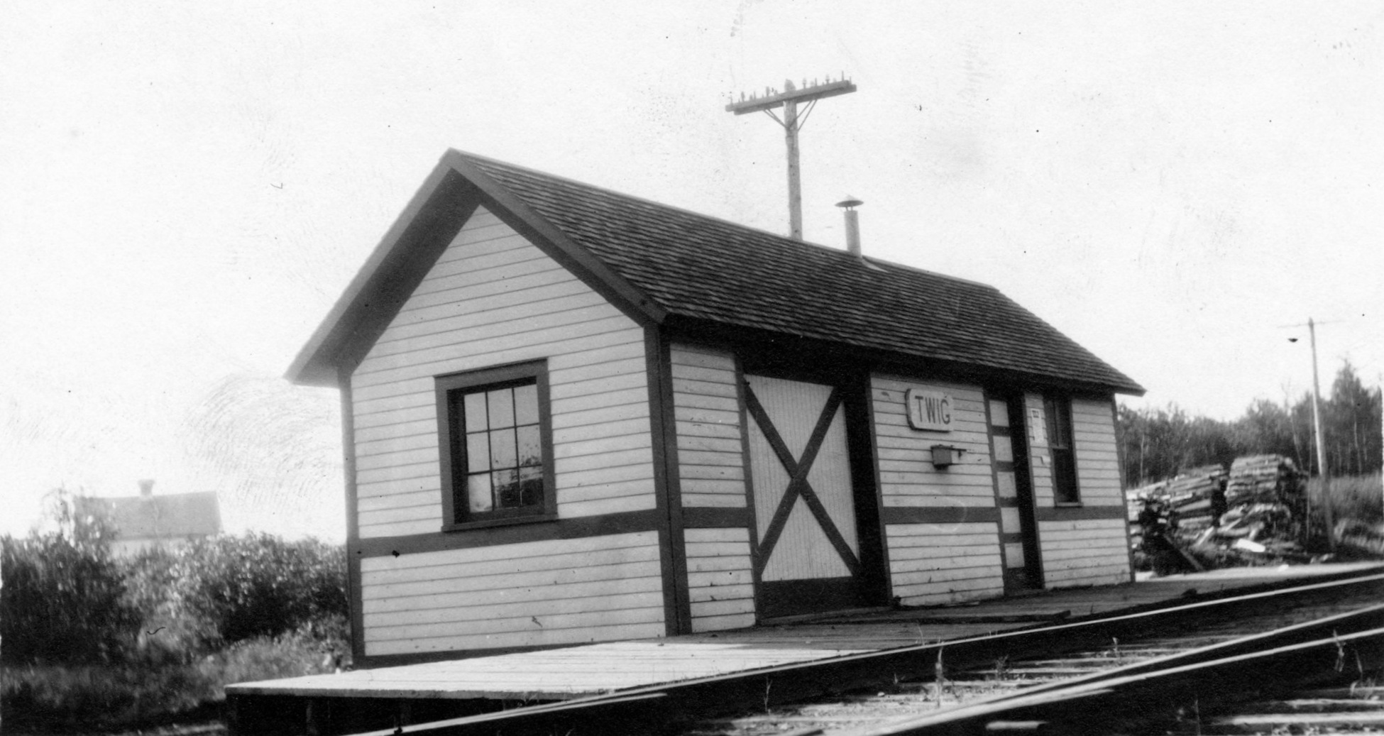
| Twig |
|
West Haugen Road (GPS: 46.876671,-92.346284) |
C | ???? | Railroad | In Use | Metal |
|
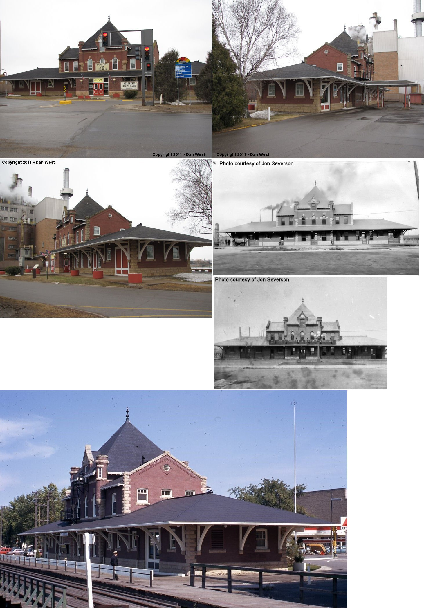
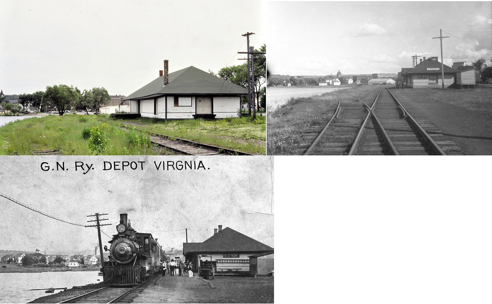
| Virginia |
|
600 Chestnut Street (GPS: 47.523117,-92.541087) |
C | 1913 | Bank | Gone | Brick |
|
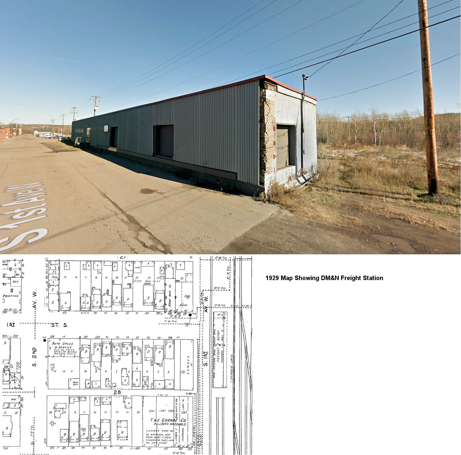
| Virginia |
|
1st Street South at 1st Avenue West (GPS: 47.522147, -92.531153) |
F | ???? | Business | Gone | Brick |
|
| Wilpen (Glen) |
|
Minnesota Discover Center 801 US-169 SW in Chisholm (GPS: 47.472098, -92.895398) |
C | 1915 | Museum | In Use | Wood |
|
| Winton |
|
218 Fall Lake Drive (GPS: 47.926572, -91.799670) |
C | 1914 | Business | None | Wood | |
| Wolf |
|
5029 County Road 7, Mt. Iron (GPS: 47.484936,-92.598529) |
C | ???? | Civic | None | Wood |
|
| STATIONS OF THE PAST | ||||||||
| Station Name |
Original Railroad |
Notes | ||||||
| Adolph |
|
|||||||
| Aerie Lake |
|
|||||||
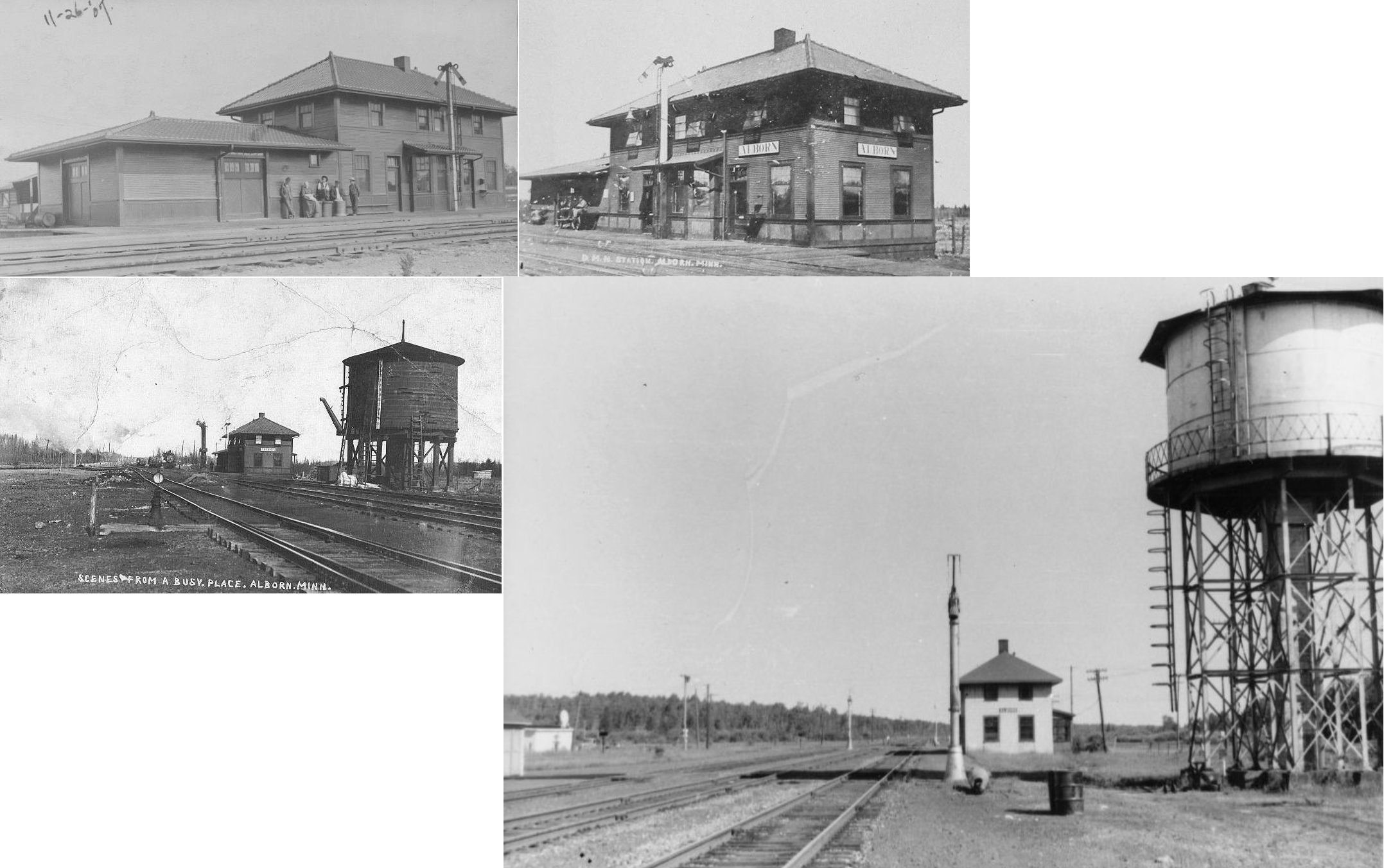
| Alborn |
|
According to DM&N annual meeting records, a new station was built here in 1907. | ||||||
| Alborn |
|
|||||||
| Allen |
|
|||||||
| Allen Junction |
|
Allen Junction was south of Allen Station. Later known as Hoyt Lakes-Allen Junction. Accroding to D&IR company records, a new station was slated to be built here in 1910-11 at a cost of $7,630. In 1917 the timber platform on the station was replaced with a concrete platform. | ||||||
| Alice |
|
|||||||
| Alvina |
|
|||||||
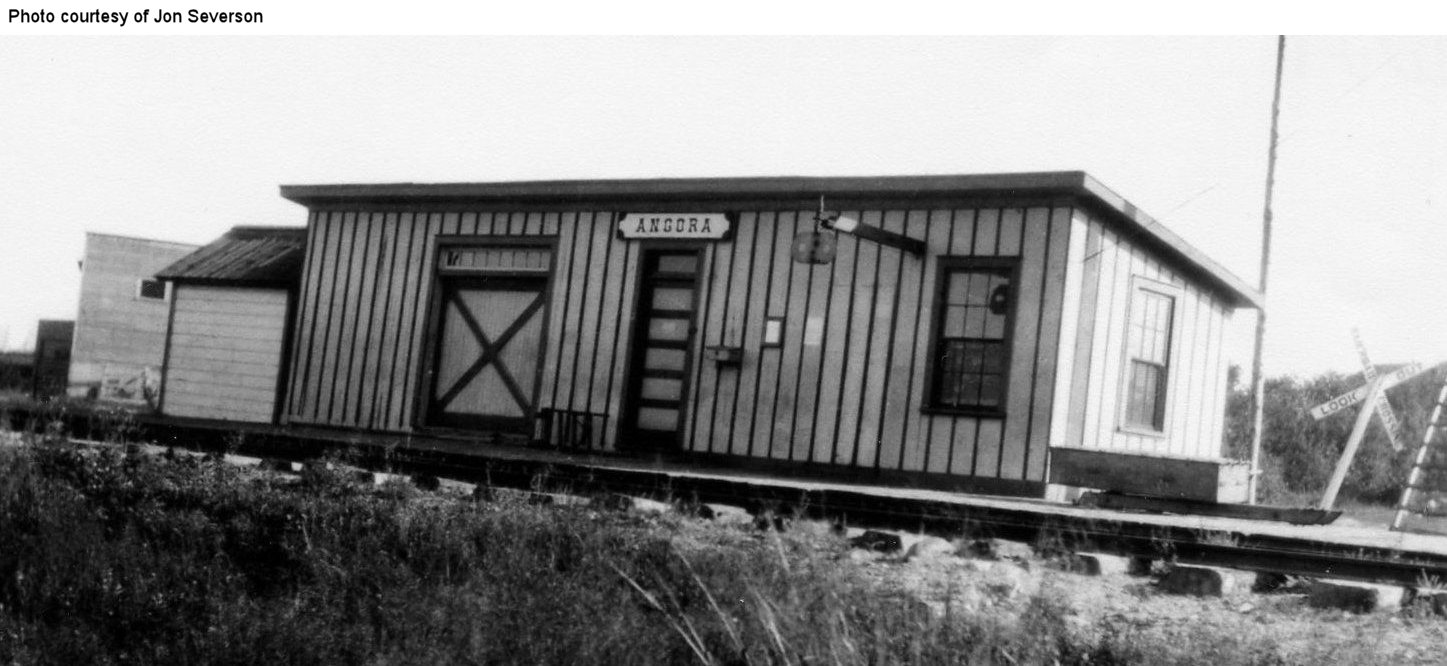
| Angora |
|
|||||||
| Arlberg |
|
According to the 1915 GN Valuations Records, only a station sign remained at this location by then. | ||||||
| Arthur |
|
|||||||
| Ash lake |
|
|||||||
| Aurora |
|
The passenger station was on the south side of Railraod Street (now 1st Avenue N.) just west of Mesaba Street (now 1st Street East) on the north side of the tracks at GPS: 47.528547, -92.235297. The freight station (added later) was on the east side of Jackson Street. | ||||||
| Baden |
|
|||||||
| Babbitt (Argo) |
|
|||||||
| Baden |
|
According to the 1915 GN Valuations Records, only a station sign remained at this location by then. | ||||||
| Bailey (Mile 55) |
|
|||||||
| Bailey |
|
See listing for "Nova" below. | ||||||
| Bartlett |
|
|||||||
| Bengal |
|
According to the 1915 GN Valuations Records, this station was built in 1900 and measured 24'x24'. | ||||||
| Birch |
|
|||||||
| Birch |
|
|||||||
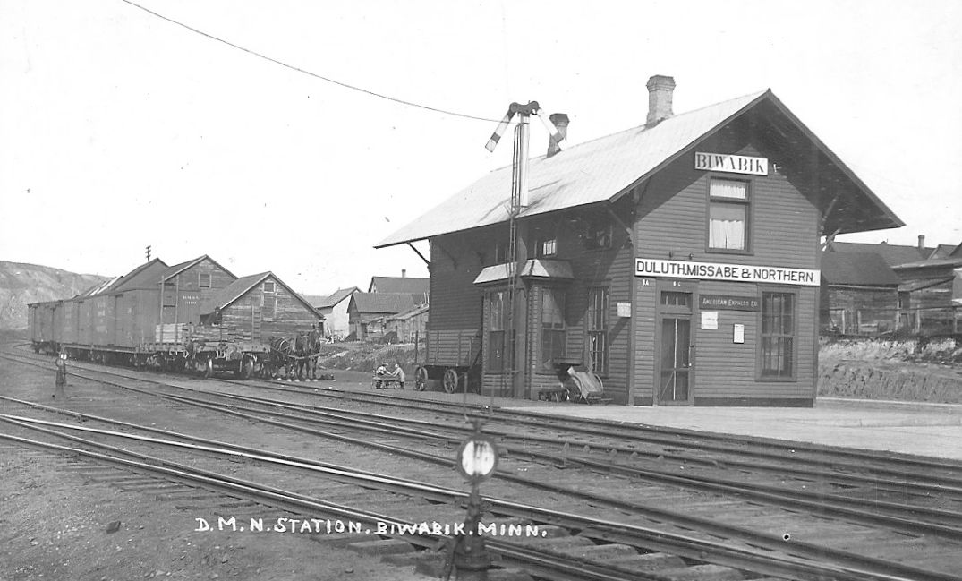
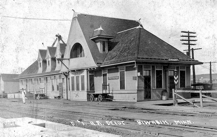
| Biwabik |
|
This station was on the north side of Main Street at GPS: 47.533320, -92.348356. It began as a one-story depot, but a second story was added in 1909 for agent's quarters (Duluth News Tribune, 10-17-1909). Later, a small addition was put on the north side. | ||||||
| Biwabik |
|
|||||||
| Boat Club |
 |
This station was between Morgan Park and New Duluth. | ||||||
| Braden Station |
|
See entry for Short Line Park below. | ||||||
| Breda (Brida) (Wissakode) |
|
|||||||
| Brevator |
|
This station was 11 miles NW of Cloquet in Section 17/18 of Brevator Township. According to the 1915 GN Valuations Records, a new passenger station was built here in 1899 that measured 24'x24'. Brevator was abandoned as a station on the GN in October 1931. | ||||||
| Brevator |
|
According to the 1915 GN Valuations Records, a new freight station was built here in 1913 that measured 12'x34'. | ||||||
| Brewer |
|
|||||||
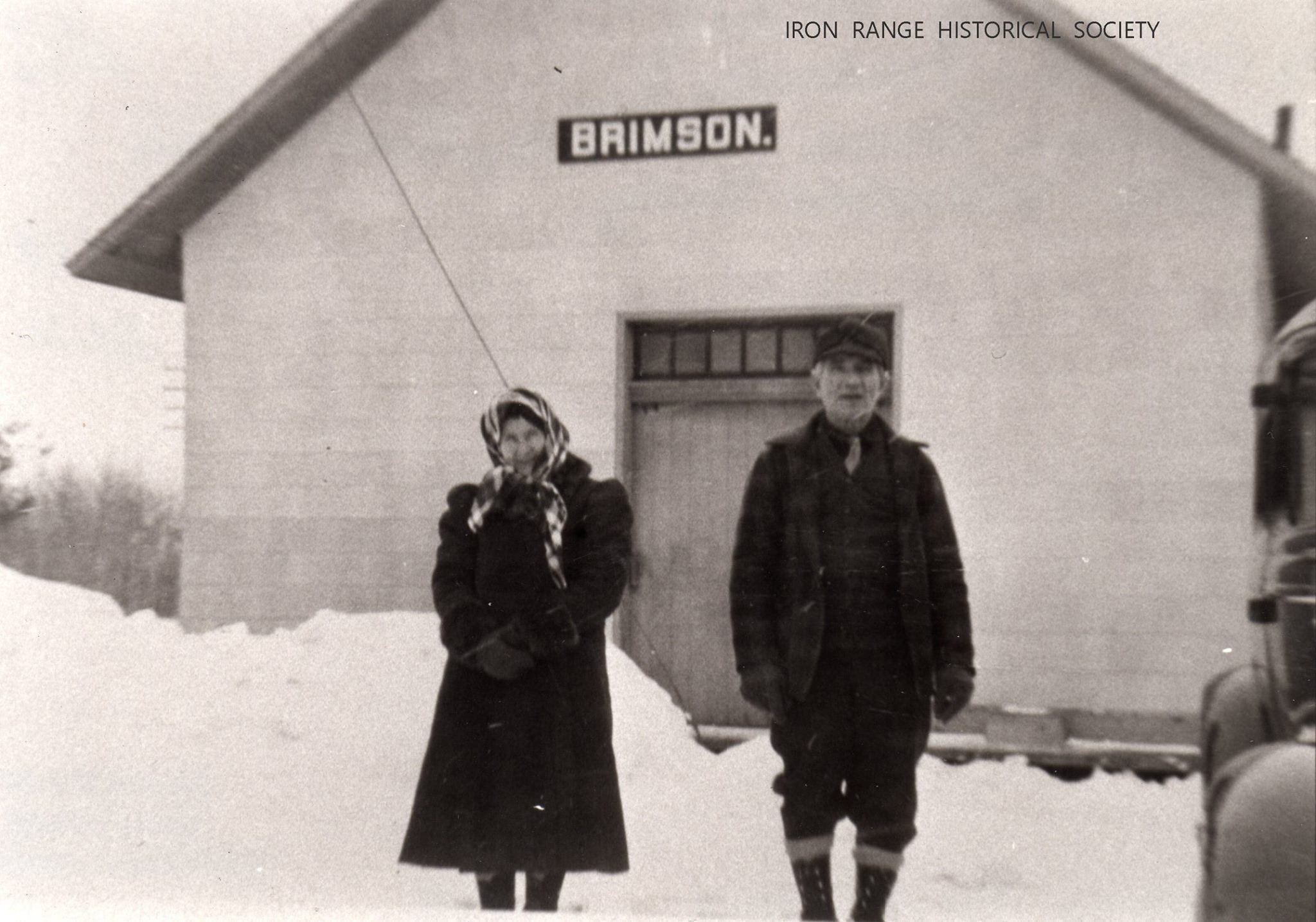
| Brimson |
|
|||||||
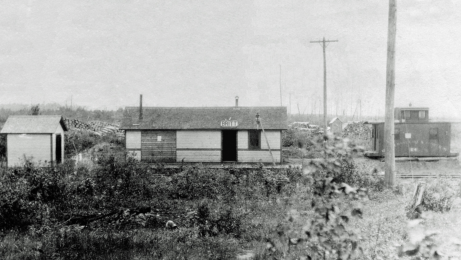
| Britt |
|
|||||||
| Britt |
|
The original station. | ||||||
| Brooklyn |
|
This station was on 13th Street (formerly Iron Street) between 16th and 17th Avenues on the north side of the tracks at GPS: 47.435564, -92.921509. According to DM&N annual meeting records, this station was built in 1911. It is shown on the 1926 Sanborn map for Hibbing. The station was gone by the 1947 updated map. | ||||||
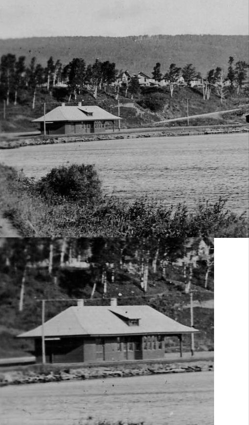
| Brookston |
|
|||||||
| Buhl (Sharon) |
|
According to the 1915 GN Valuations Records, a new station was built here in 1901 that measured 24'x84'. It was around that time that the name was changed from "Sharon" to "Buhl." The station was at the end of Forest Street at GPS: 47.497590, -92.777456. | ||||||
| Buhl |
|
This modern station was likely in the same location as the original station. | ||||||
| Buhl (Sharon) |
|
This combination station opened in December 1910 or early 1911 (Duluth News Tribune, 12-20-1910). | ||||||
| Burnett |
|
|||||||
| Calyx |
|
This place no longer exists. It can be seen on maps from 1914. It was located between Sand Lake and Coon Lake, just to the NW of Silica. | ||||||
| Cardiff |
|
According to the 1915 GN Valuations Records, only a station sign remained at this location by then. Some sources list Kinross and Cardiff as the same station with a name change, whereas others list them as seperate stations, but less than a mile apart. It could be that the station was renamed and moved a short distance at the same time. | ||||||
| Casco |
|
According to the 1915 GN Valuations Records, a new station was built here in 1907 that measured 24'x24'. | ||||||
| Central Lakes |
|
|||||||
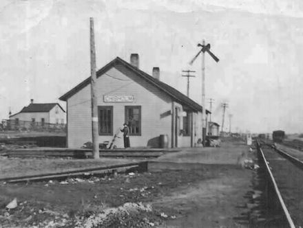
| Chisholm |
|
According to the 1915 GN Valuations Records, a new station was built here in 1905 that measured 24'x78'. Originally known as Barclay Junction on the GN, the name of the station was changed to "Chisholm" in August 1903. The station was at the corner of what is now 1st Avenue and 2nd Street SE (formerly East Birch Street). | ||||||
| Chisholm |
|
There were passenger and freight stations on the south side of 6th Street (formerly Oak Street) between 1st and 2nd Avenues at approximately GPS: 47.483240, -92.881956. A new passenger station was built in 1910 (Duluth News Tribune, 4-27-1910). | ||||||
| Clapper |
|
|||||||
| Clifton |
|
|||||||
| Colby |
|
|||||||
| Congo |
|
This station was at the northern end of Maki Road, just east of Paupore on the GN. According to the 1915 GN Valuations Records, a new station was built here in 1911 that measured 24'x24'. | ||||||
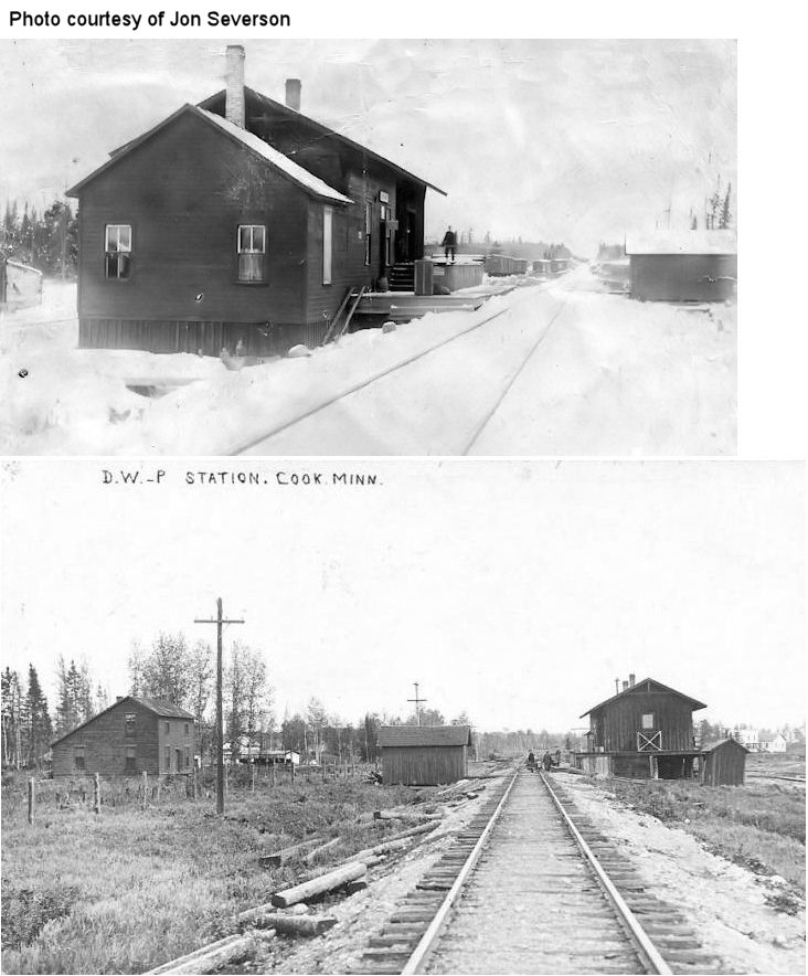
| Cook (Ashawa) (Cook House) |
|
The town changed its name to Cook to avoid confusion with Oshawa, MN. The station was on old MN-11 between Owens Avenue and River Street (1941 street names). | ||||||
| Coons |
 |
This station, which was in Solway Township, was also known as "Coons Gravel Pit." | ||||||
| Culver |
|
According to the DM&N annual meeting report of 1913, a new station was built here that year. | ||||||
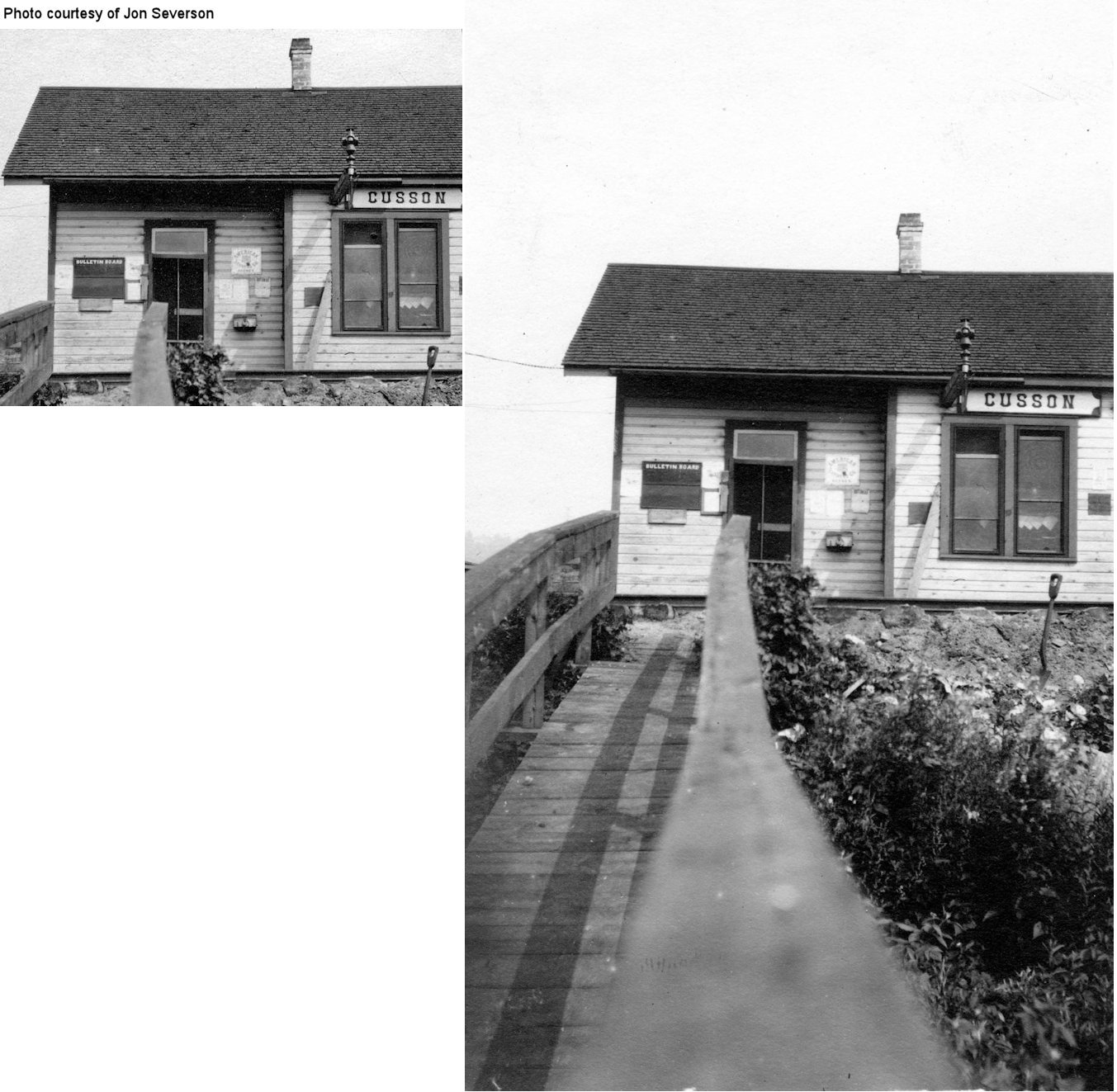
| Cusson |
|
|||||||
| Darrow |
|
This station was south of Frederick (see below). It was in the vicinity of CR-442 (Township 56 North, Range 20 West, Section 31) | ||||||
| Davis (Daves) |
|
Both the D&IR and DM&N went through here. | ||||||
| Deforest |
|
See entry below for Eveleth (Deforest). | ||||||
| Denham lake |
|
|||||||
| Dewey Lake |
|
|||||||
| Dibbell (Dibble) |
|
|||||||
| Draco |
|
This station was between Nagonad and Brevator on the St. Louis River (in Section 22 of Brevator Township). According to the 1915 GN Valuations Records, only a station sign was at this location that year. The 1963 list of stations abandoned by the GN since 1940 lists Draco as an abandoned station, but gives no date for the abandonment. | ||||||
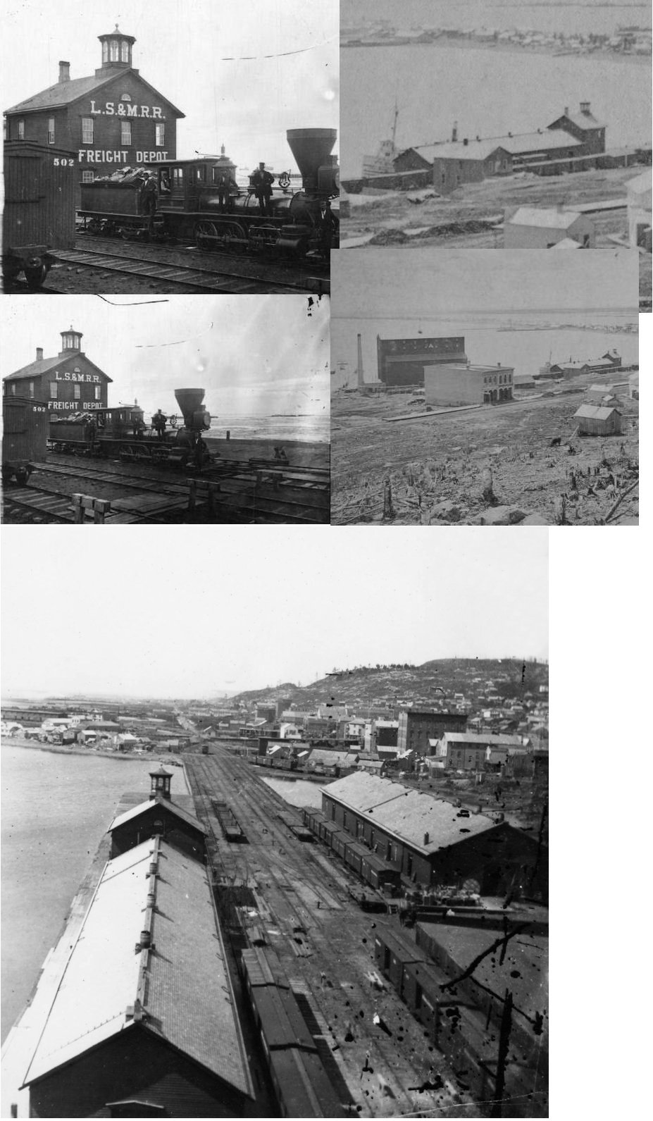
| Duluth |
|
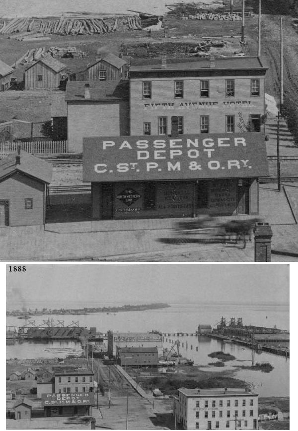
The old Eastern Minnesota Railway (later merged into the GN) passenger station was on Michigan Street between South 6th Avenue West and South 7th Avenue West (now gone in this location) at approximately GPS: 46.780352, -92.105481. This station is shown on the 1890 city atlas. | ||||||
| Duluth |
|
There was an Eastern Minnesota Railway freight station on 8th Avenue at Michigan Street in the vicinity of GPS: 46.779088, -92.107182. This station is shown on the 1890 city atlas. | ||||||
| Duluth |
|
A freight station was at 630 West Michigan Street, just to the SW of Union Station. This may have been the old Eastern Minnesota Railway passenger station (see above) converted to a freight station after the building of Union Station. | ||||||
| Duluth |
 |
There was an early St. Paul & Duluth freight station at the foot of East 3rd Avenue at GPS: 46.788923, -92.093567. This station is shown on the 1884-1888 Sanborn maps, but was gone by 1909. | ||||||
| Duluth (20th Avenue) |
|
There was a passenger station at 220 South 20th Avenue West (near where I-35 is today) in the vicinity of GPS: 46.802681, -92.069176. | ||||||
| Duluth |
|
A freight station was at 114 S. 5th Avenue West, just to the NE of Union Station. There is a parking deck at this location today. | ||||||
| Duluth |
|
There was a freight station at the foot of Commonwealth Avenue near Hudson Boulevard. | ||||||
| Duluth |
|
There was a freight warehouse on Rice's Point NE of 3rd Street. | ||||||
| Duluth |
|
There was a freight house to the SE of Union Station at the foot of 7th Street (now gone) in the vicinity of GPS: 46.778355, -92.101864. | ||||||
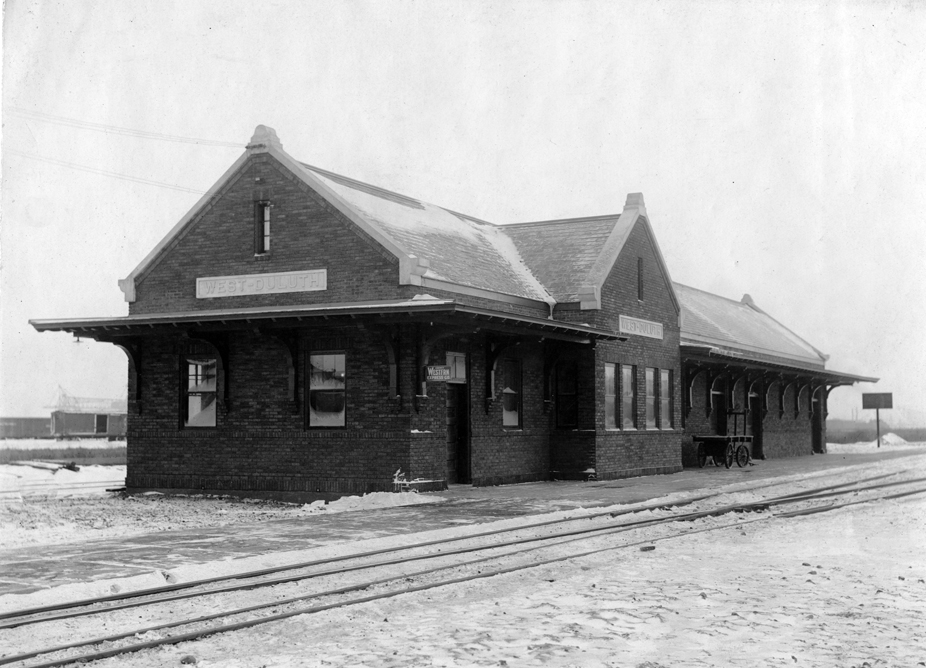
| Duluth (West Duluth) |
|
West Duluth passenger station. The 1893 map shows a St. Paul & Duluth RR station on the east side of North Central Avenue south of Grand Avenue at GPS: 46.739994, -92.165791. Later the address of this station is listed as 5400 West Wadena Street. It was torn down sometime between 1956-1962. | ||||||
| Duluth (West Duluth) |
|
West Duluth freight station. This was across the tracks from the station listed above. | ||||||
| Duluth (West End Depot) |
|
This station was SE of Grand Avenue between Main Street and South 63rd Avenue West (formerly 8th Avenue). It was located at approximately GPS: 46.733163, -92.175962. The station is shown on the 1890 city atlas as "West End Depot." | ||||||
| Dultuth (Stowell Station) |
|
This station was on the south side of the tracks at the south end of South Central Avenue at GPS: 46.728441, -92.166753. It was on the St. Paul & Duluth Short Line. | ||||||
| Duluth (Hazelwood) |
|
This station was on the SW side of 39th Avenue West (formerly Cliff Avenue) on the north side of the tracks at GPS: 46.739994, -92.165791. The station was gone by 1909. | ||||||
| Duluth (Short Line Jct.) (Rices Point) |
|
This station was off Birch Avenue (now gone) SW of Garfield Avenue in the vicinity of GPS: 46.766580, -92.118092. It may have been called Rice's Point on some timetables. It was gone by 1909. Not to be confused with Short Line Park. | ||||||
| Duluth (Superior Street) |
|
The 1890 map shows the "Superior Street Station" near the intersection of Alexander Street and 28th Avenue (formerly Connecticut Avenue) in the vicinity of GPS: 46.810919, -92.059528. This station was called the Superior Street Station because it was close to London Road which was called Superior Street before the street names were changed. | ||||||
| Duluth (Crosley Park) |
|
This station was on East Superior Street just NE of where South 51st Street (formerly Fahnestock Street) crosses the tracks at GPS: 46.833371, -92.021320. | ||||||
| Duluth (London) (Lakeside) |
|
This station was on East Superior Street at North 47th Avenue (formerly Sargent Street) at GPS: 46.828890, -92.029450. This is shown on Frederick Roe's City of Duluth Atlas from 1890. This is most likely the station that was moved to Knife River (Lake Co.) in the early 1900s as traffic in that area shifted to interurban ridership. The station may have also been called "Lake View," "New London," or "47th Avenue Station" on some old timetables. | ||||||
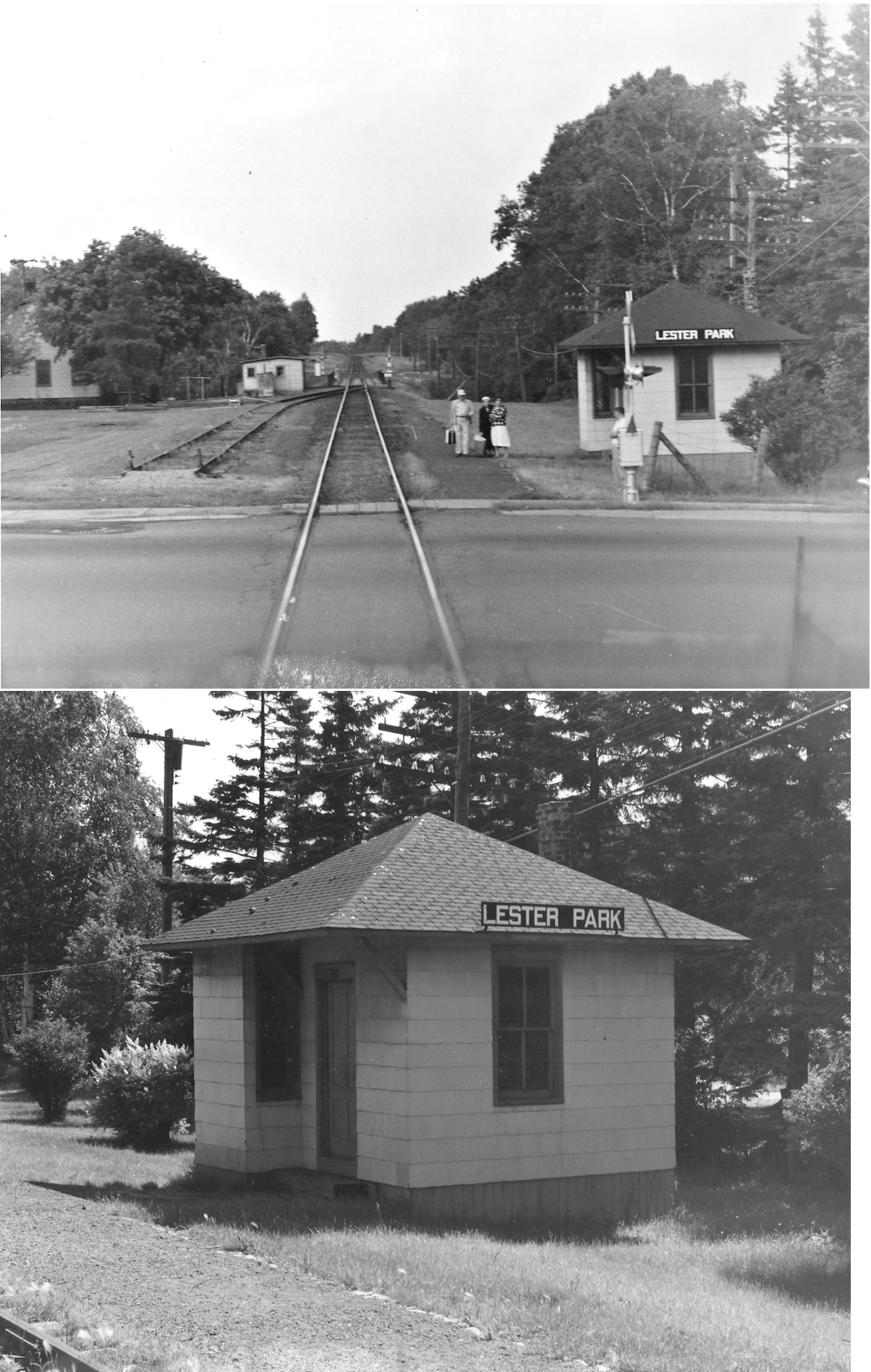
| Duluth (Lester Park) |
|
This location is called "Lakeview" on maps from the early 1900s. The station was on the east side of North 60th Avenue East (formerly Illinois and formerly Lincoln Street) at GPS: 46.837984, -92.008546. The photos are likely of a later-generation station here. | ||||||
| Duluth (East Lester) |
|
The 1890 atlas shows an East Lester Station between Tower and Garfield Avenues. These streets are no longer there, but the station would have been in the general vicinity of GPS: 46.839709, -92.002388. Given its depiction on the map, this station may have been planned and never built or it may have just been a small flag stop. It is not on the 1902 atlas. This station is shown on Roe's 1890 atlas of Duluth in the 1893 supplement section. It is shown in the Lester Park 4th Division which was just platted at the time and may not have been developed. | ||||||
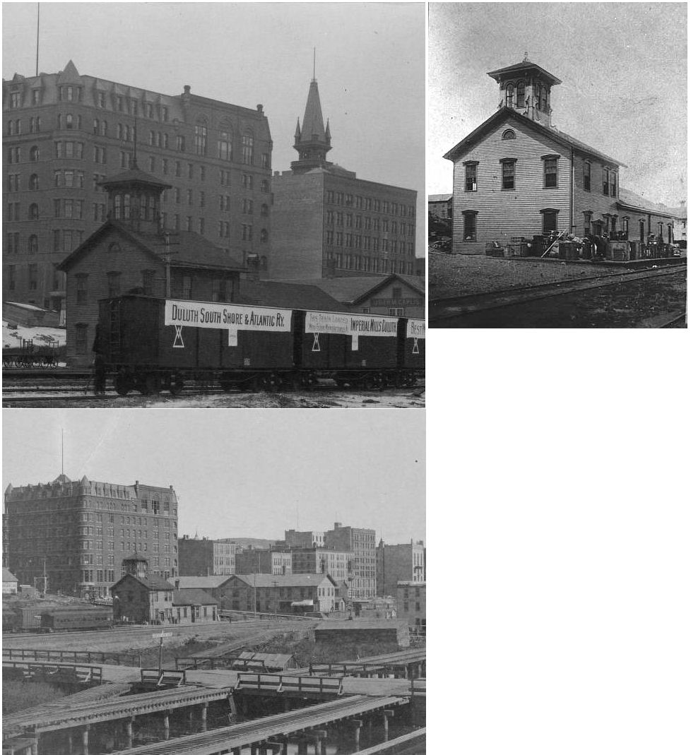
| Duluth |
 |
This station was at 200 5th Avenue West. This is near where Harbor Drive crosses over Railroad Avenue today at approximately GPS: 46.781016, -92.101981. The station was also used by the DWP. This station is shown on the 1888 Sanborn map. | ||||||
| Duluth |
|
The original Omaha freight station was built in 1886 and is shown on the 1888 Sanborn map. It was between 4th and 5th Avenues West just to the NE of the original Omaha passenger depot at approximately GPS: 46.781437, -92.101905. | ||||||
| Duluth |
|
A new brick freight station built in 1903 at 232 5th Avenue West at Commerce Street (now Railroad Street) at approximately GPS: 46.781117, -92.101910. It was also used by the DWP. | ||||||
| Duluth |
|
This second generation station was built in 1897 and torn down in the 1960s. It was between 4th & 5th Avenues West, but was accessed via the bridge on 5th. | ||||||
| Duluth |
|
There was a freight station at the foot of 8th Avenue West at GPS: 46.777075, -92.103747. Over the years there were additions to the station. | ||||||
| Duluth (W. Duluth) |
|
This station was at 5431 Grand Avenue at Central Avenue and was torn down in 1961. | ||||||
| duluth |
|
This Lake Superior & Mississippi RR freight station was located at 3rd Avenue East and Michigan Street. | ||||||
| Duluth |
|
Originally a St. Paul & Duluth passenger station, this is the first Union Station. It was built in 1869 and was located on the site of the existing Union Station south of West Michigan Street between 5th and 6th Avenues at GPS: 46.780987, -92.103895. The Spalding Hotel is in the background of the photo. | ||||||
| Duluth (West Duluth) |
|
According to DM&N annual meeting records, a new station was built here in 1910. | ||||||
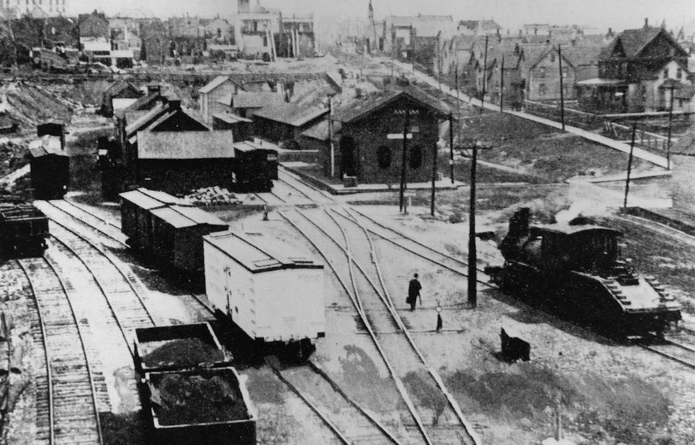
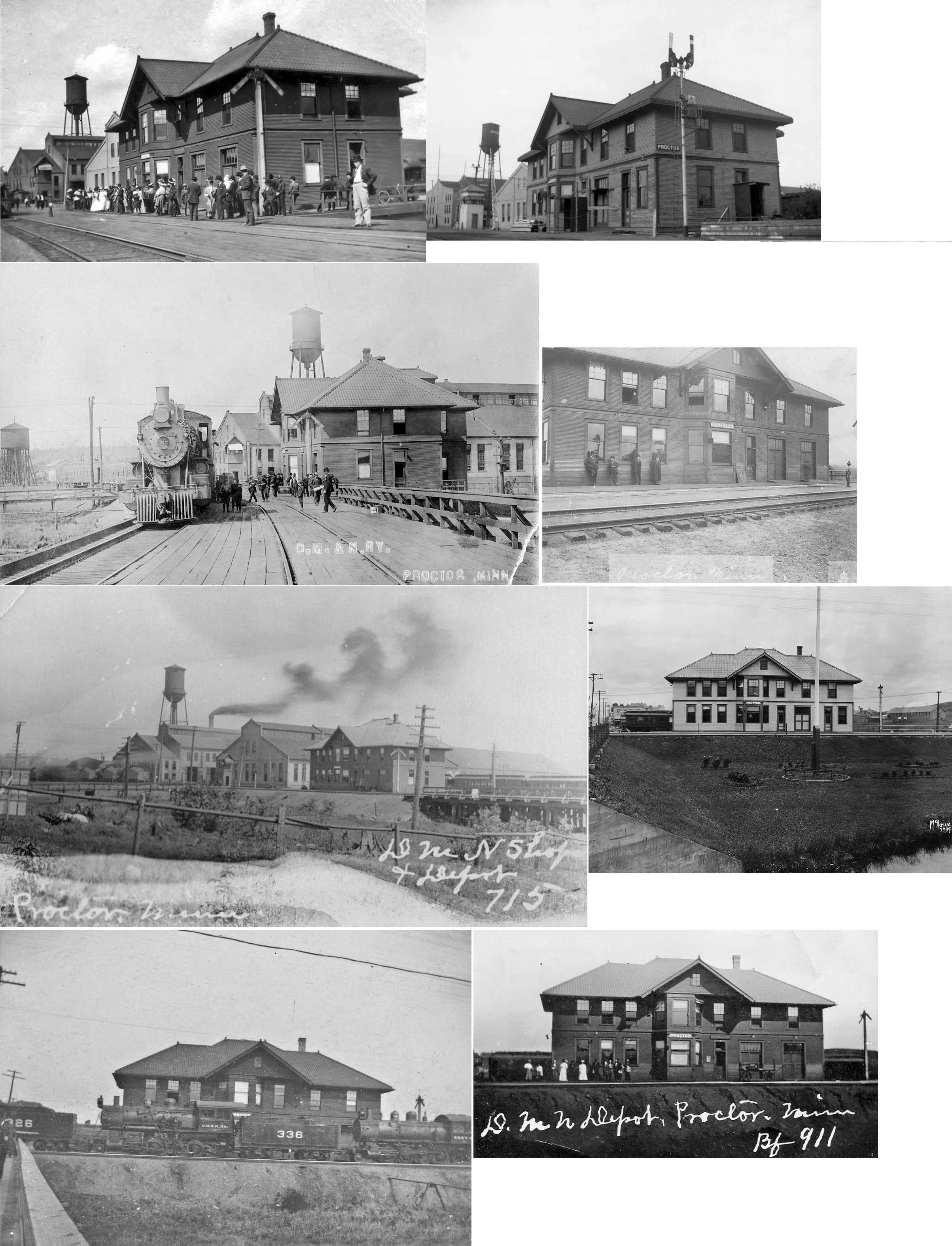
| Duluth (Missabe Junction) |
|
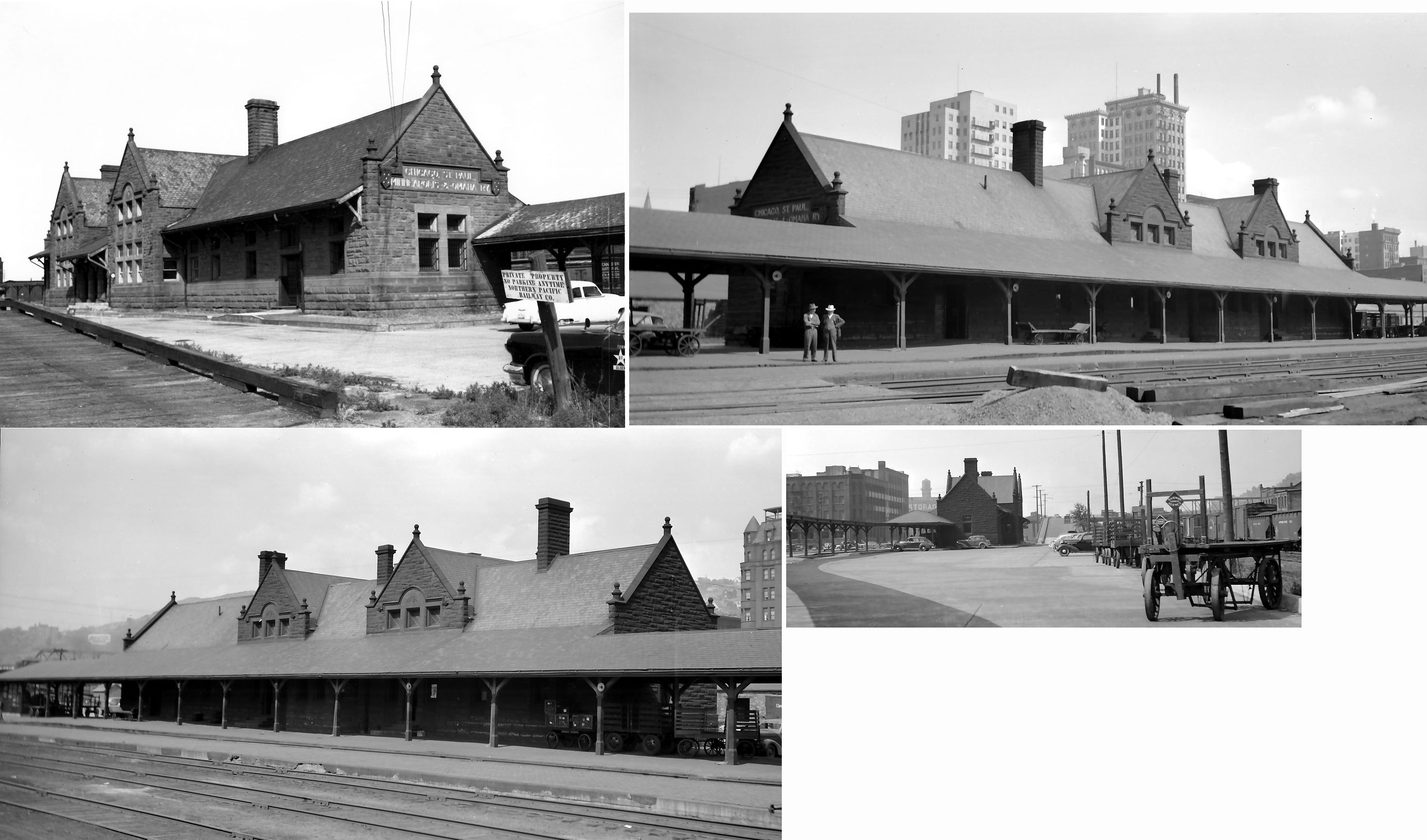
According to DM&N annual meeting records, a new station was built here in 1911. That new station was two stories, whereas the old station was one story. The photo shows the two-story station when it was bing used as an office and the map shows the one story station at the same location. | ||||||
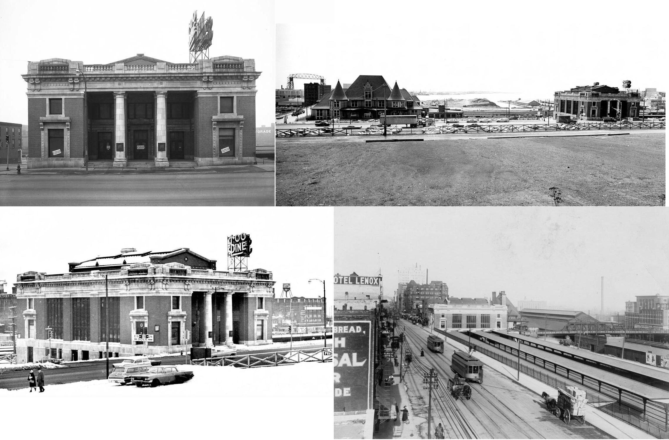
| Duluth |
 AND |
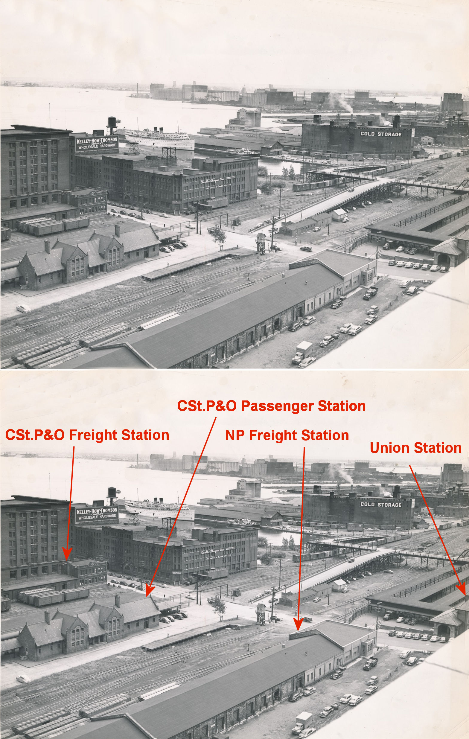
This station, opened in July, 1910, was located at 602 West Superior Street (GPS: 46.780883, -92.105644). It also served the Duluth, South Shore & Atlantic RR and the Duluth, Missabe & Northern. It was abandoned in 1961 and torn down in 1972. When the Soo Line built the station in 1910 the NP had a lock on the right of way. The Soo was able to sneak its way in, except for a quarter mile or so where the NP tracks were right up against a solid rock bluff. The line also had to somehow get around the Bridgeman-Russell Creamery, so the railroad tunneled through solid rock under Michigan Street to get to the depot. | ||||||
| Duluth |
|
There was a freight station at the foot of 10th Avenue West. | ||||||
| Duluth (West Duluth) |
|
This Soo Line/Duluth South Shore & Atlantic station was at the foot of Ramsey Street. It was built in 1916. | ||||||
| Duluth (West Duluth) |
|
This was the Soo "West End" depot. It was located at 2902 West Superior Street (GPS: 46.758895, -92.134277). The Clyde Iron Works building is in the background. It was later used as a beer distributorship after its railroad days were over. | ||||||
| Dumblane (Dumblance) |
|
According to the 1915 GN Valuations Records, only a station sign remained at this location by then. | ||||||
| Eagles Nest |
|
|||||||
| Elcor (Elba) |
|
|||||||
| Ellis |
|
See listing for Olcott. | ||||||
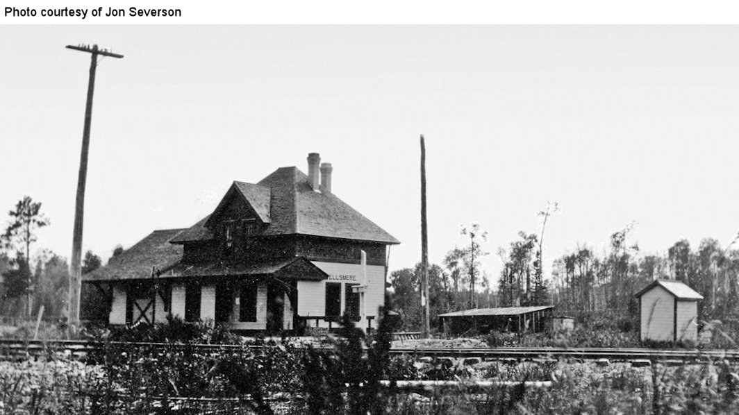
| Ellsmere |
|
|||||||
| Elmer |
|
Elmer was in Section 5 of Meadowlands Township. According to the DM&N annual meeting report of 1915, a new station was built here in 1914 by the Linden Construction Company. | ||||||
| Elmer |
|
|||||||
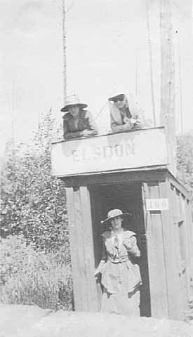
| Elsdon |
|
This was the next station north of Cusson. | ||||||
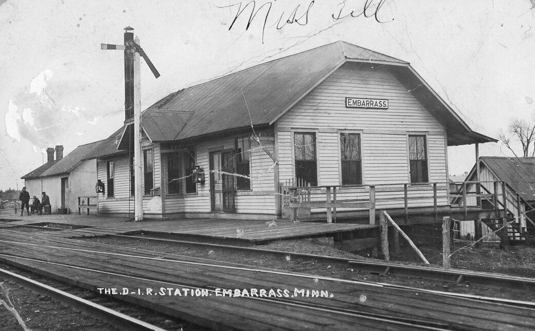
| Embarrass |
|
According to the D&IR shareholders meeting minutes from 1916, money was allocated for the extension of the freight house here in the amount of $135. In 1917, $1,000 was allocated to add a 14'x28' one-story addition to the depot. | ||||||
| Eveleth |
|
The first D&IR depot here was on the old track alignment that was relocated due to mine encroachment sometime between 1897 and 1900. There was a very small passenger station and larger freight station. It was at what was the west end of Jones Street at the time at approximately GPS: 47.463272, -92.547722. | ||||||
| Eveleth |
|
The second depot here, built around 1900, was a terminal-type depot attached to a freight house. According to the D&IR shareholders meeting minutes from 1912, money was allocated for the extension of this station that year. This depot was removed when the new station was built in 1923. | ||||||
| Eveleth |
|
The original depot here was at the corner of Monroe Street and Carrie Avenue at GPS: 47.461686, -92.543582. It was a single-story depot and was destroyed by burglars who attempted to blow up the safe with dynamite in 1902. There may have been a previous station on the old alignment, but that specific area is not shown on Sanborn maps from that time period (although the original D&IR station on its old alignment is shown). | ||||||
| Eveleth |
|
The second depot here was at the same location as the the original at the corner of Monroe Street and Carrie Avenue, but the west side of the station was two stories. There was also a freight house on the east side of the station. According to DM&N annual meeting records, the station was remodeled in 1907. After the mine began encroaching on the railroad in this part of town and city leaders in Eveleth pushed for a "union" depot, the DM&N moved passenger service to the 1923 D&IR/DM&N station on Fayal Street (still standing) (Duluth News Tribune, 1-20-1922, 6-7-1923). According to maps, the station was still standing in the late-1930s. | ||||||
| Eveleth (Deforest) |
|
An early passenger station here was knocked down in 1911 when two loaded ballasting cars push against the platform. The station fell into the swamp below. According to the The Duluth News Tribune (7-12-1911), the plan was to put the depot back in place and fill in the swamp. | ||||||
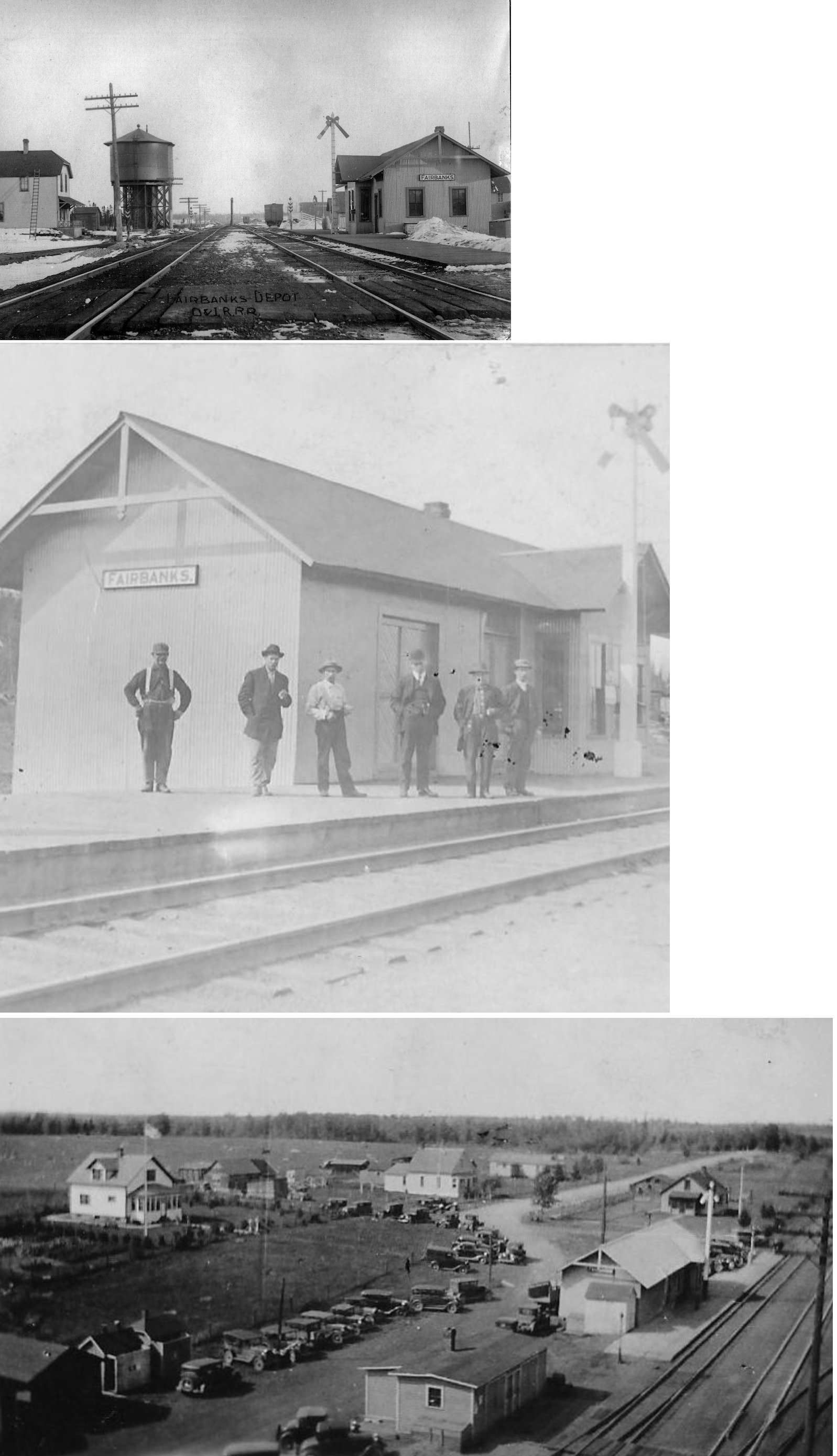
| Fairbanks (Bassett Lake) |
|
It has been reported that this station still exists about 200-300 yards north of its original location on the west side of the tracks. Can anyone confirm that with a photo or GPS coordinates? According to the D&IR shareholders meeting minutes from 1914, money was allocated for the extension of this station. | ||||||
| Fens (Dibbell) |
|
Fens is the name of this location on modern maps. | ||||||
| Fermoy |
|
Abandoned as a station on the GN in 1926. | ||||||
| Flanders |
|
According to the 1915 GN Valuations Records, a 24'x24' station was here. No build date was given. Abandoned as a station on the GN in 1923. | ||||||
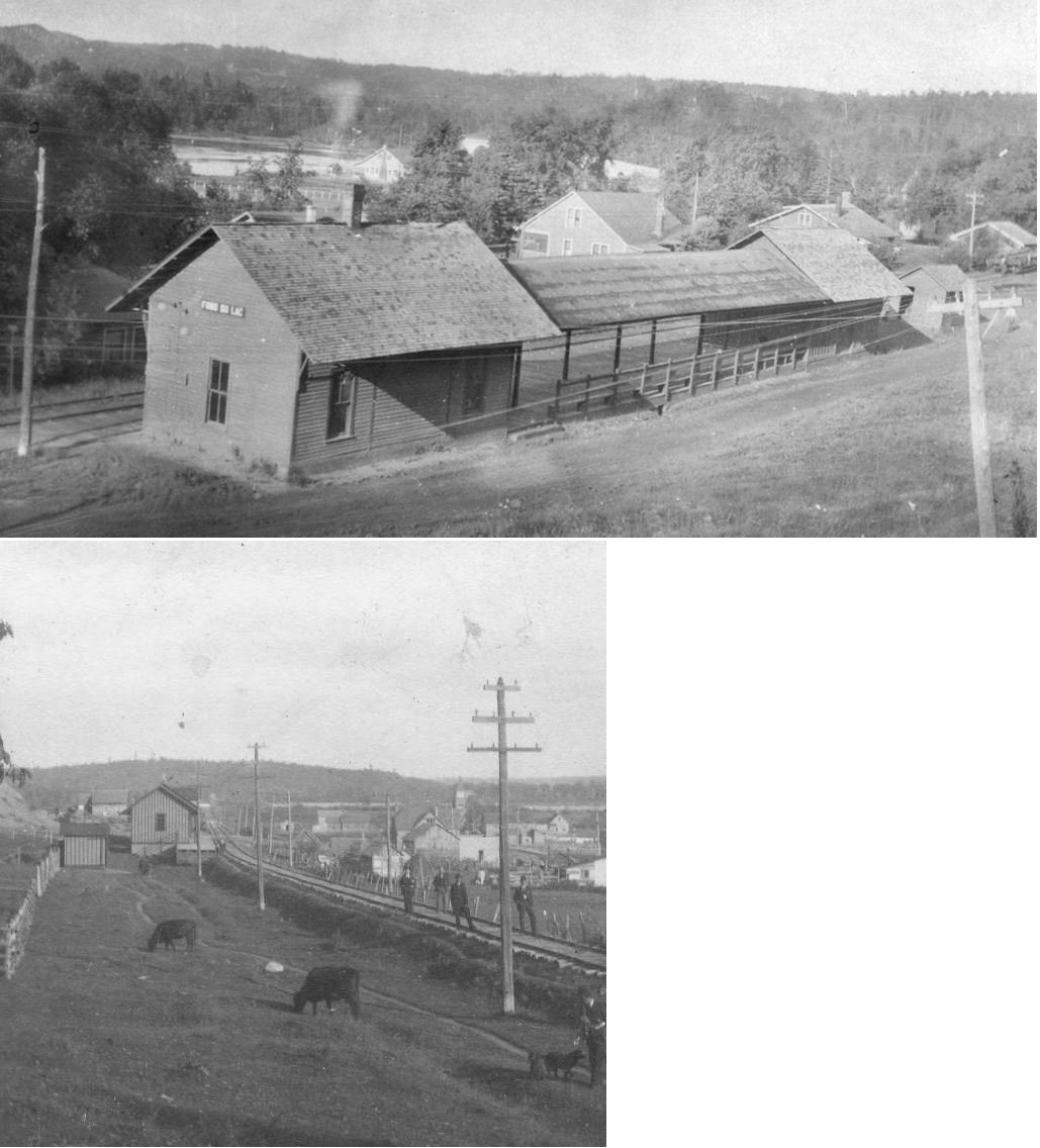
| Fond Du Lac |
|
This passenger and freight station with covered platform in between was built in 1897. The passenger station was 20'x31' and the freight house was 18'x24'. It was on the corner of 133rd Street and 4th Street (formerly Glass Street) at approximately GPS: 46.661188, -92.277801. In later years only the freight station part remained (as of the Sanborn map 1950 revision). | ||||||
| Fond Du Lac (East Fond Du Lac) |
|
The East Fond Du Lac station was a mile from the Fond Du Lac station. According to the 1917 NP Valuations Records, an 8'x21' shelter shed made from an old boxcar was installed here in 1902. | ||||||
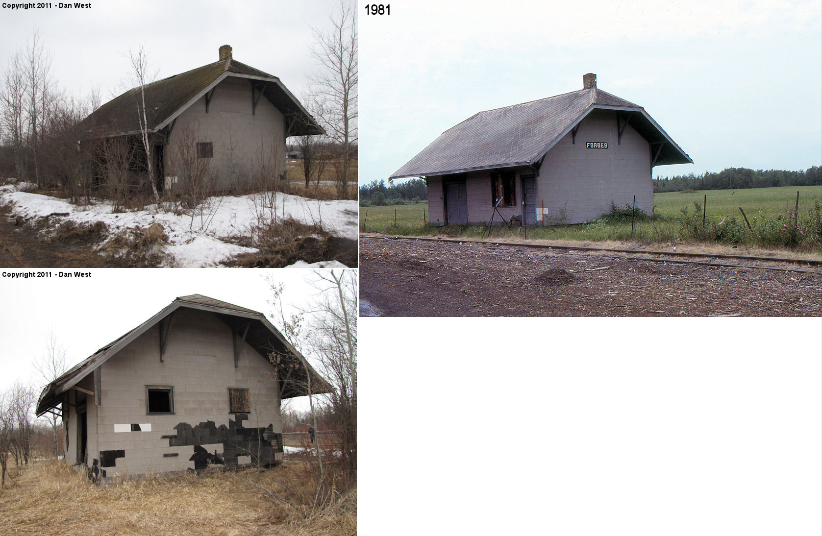
| Forbes |
|
The original station here. | ||||||
| forbes |
|
This station was on the south side of CR-16 (Town Line Road) on the west side
of the tracks. (GPS: 47.371406,-92.604232). It sat vacant for many years and was torn down sometime between 2012-2014. |
||||||
| Forsman (Taber) |
|
This station was between Virginia and Vermilion Lake it was named for settler Victor Forsman who lived in the area in the 1920s. | ||||||
| Franklin |
|
|||||||
| Fraser (Exmoor) |
|
|||||||
| Frederick |
|
This station was just south of Riley. The location no longer exists. It was in Township 56 North, Range 20 West, Section 18. | ||||||
| French River |
|
According to D&IR annual meeting notes from 1913, an appropriation was made for a new freight house here in the amount of $396. | ||||||
| Gary |
|
This station was on Gary Street at the NP tracks. There may have also been a station at Gary Junction (see map, which may have speculative rather than actual). | ||||||
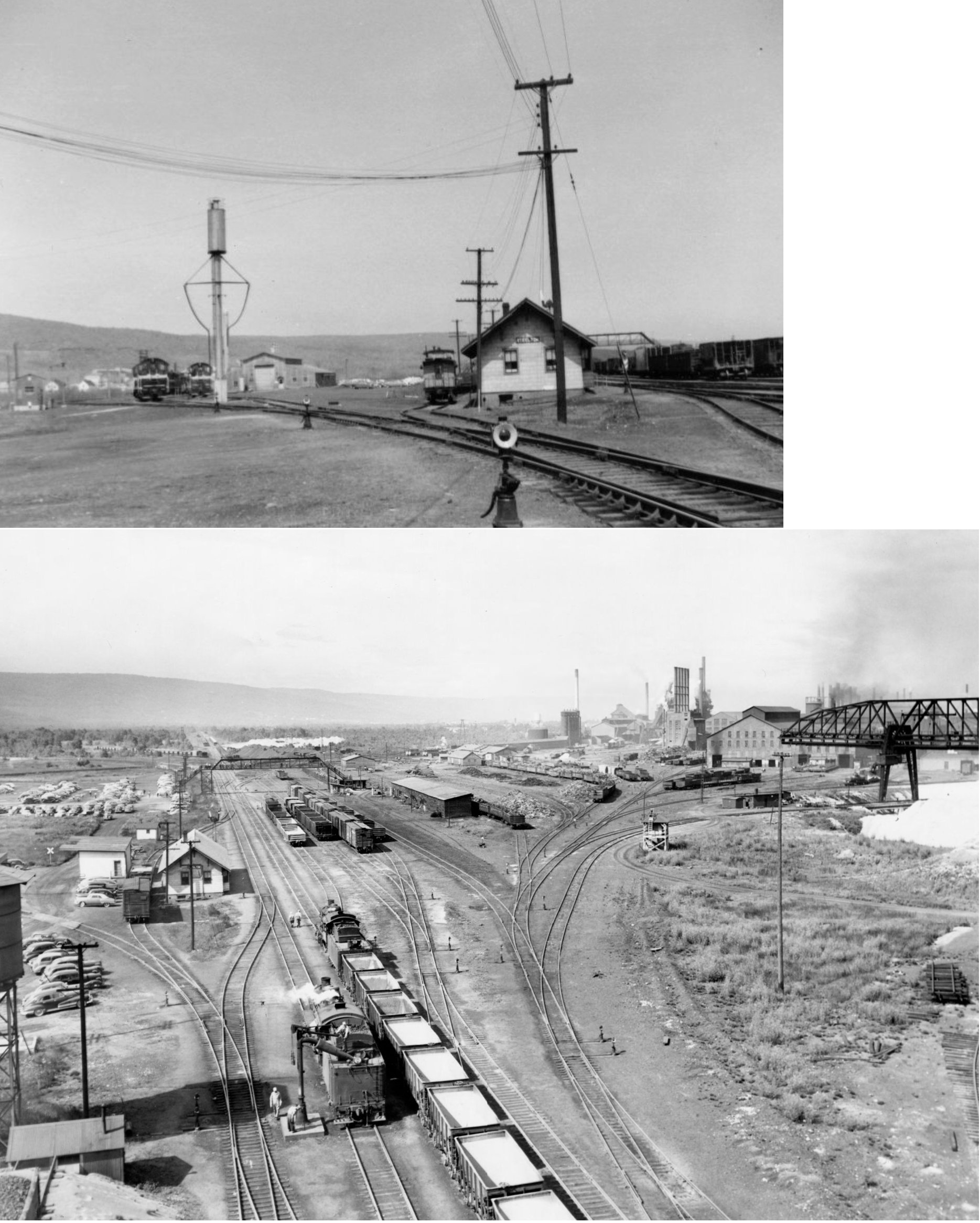
| Gary (Steelton) |
|
There was a freight station at 527 East Gary Street. A freight station and office was built here in 1915 (Duluth News Tribune, 11-1-1915). | ||||||
| Gary (Steelton) |
|
An addition and improvements were made to this passenger station in 1917 (Duluth News Tribune, 6-4-1917). | ||||||
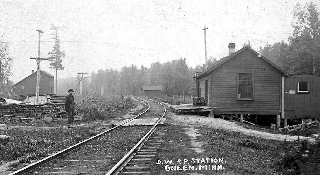
| Gheen (Alvina) |
|
|||||||
| Gheen |
|
This appears to be a newer and larger station that the one pictured above, however, it appears that the old station may have been part of the new station. | ||||||
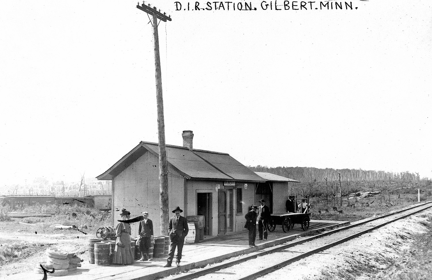
| Gilbert |
|
This terminal-type combination station was on the north side of Arizona Avenue (when it used to cross the tracks there) at approximately GPS: 47.493263, -92.462264. It began as a small passenger station, but a steel-reinforced freight end was added later. | ||||||
| Glendale |
|
|||||||
| Gowan |
|
See listing below for Mirbat. | ||||||
| Graff |
|
According to the D&IR annual meeting report of 1912, a new station was built here that year. It is unclear where this station was. Graff may have been an interchange with the Scott-Graff Lumber Company on a logging branch, and those stations disappeared as quickly as they reappeared. The other possibility is that Scott-Graff owned a saw mill in the Duluth harbor that was served by the D&IR, but it was via an agreement with NP for trackage rights. Does anyone know for sure where this station was? | ||||||
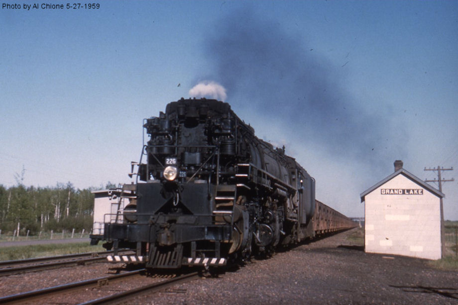
| Grand Lake |
|
According to the DM&N annual meeting report of 1913, a new station was built here that year. | ||||||
| Gunderson |
|
Also known as Gunderson Spur, it's not clear exactly where this station was. | ||||||
| Haley |
|
|||||||
| Harris Lake |
Duluth & North- eastern RR |
Eight miles SW of Fairbanks. Also known as Harris Junction. | ||||||
| Hibbing |
|
There was an early Duluth, Mississippi River & Northern station on Railroad Street between 2nd and 3rd Avenues across the tracks from the original DM&N station. The DMR&N became part of the Eastern Railway Company (in 1899) which was bought by the Great Northern (in 1907, although this particular station was gone by 1904). | ||||||
| Hibbing |
|
This station was built sometime between 1900-1904 in old North Hibbing. It was on Railroad Street between 2nd and 3rd Avenues on the south side of the tracks. Around 1904 a seperate freight station was added just to the west of the passenger station. Sometime between 1908-1913 a new larger freight station was built a but further to the west near 1st Avenue. | ||||||
| Hibbing |
|
This later-generation freight station was between 5th and 6th Streets on the south side of the tracks at GPS: 47.430015, -92.936053. | ||||||
| Hibbing |
|
The first DM&N station in Hibbing was on Railroad Street between 2nd and 3rd Avenues. Prior to this station, an old boxcar was used as the station. | ||||||
| Hibbing |
|
This was the second DM&N station in Hibbing, built sometime between 1900-1904. It was on South Street between 2nd and 3rd Avenues. The tracks were removed and it was torn down sometime around 1911 and replaced with a public park. It was replaced by the station listed below (which also had a relatively short life). | ||||||
| Hibbing |
|
According to DM&N annual meeting records, this station was built in 1911. It was located in the old town of Hibbing before the town was moved in the early 1920s due to encroaching mines. It was east of 1st Avenue in the vicinity of GPS: 47.443296, -92.941423. After this station went out of service it was used as a woodworking shop and was still standing as of 1926 (as shown on the Sanborn map from that year). The station was eventually demolished rather than moved and a new station was built at the new town site. | ||||||
| Hibbing |
|
This freight station was on the west side of 1st Avenue in the old town of Hibbing (the passenger station was on the east side of 1st Avenue). According to DM&N annual meeting records, this station was also built in 1911. | ||||||
| Hibbing |
|
When the third-generation passenger station above went out of service, a new station was built | ||||||
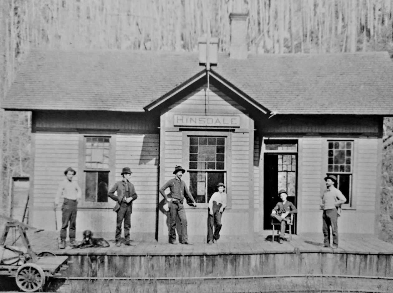
| Hinsdale |
|
|||||||
| Holter Trimble |
|
This was NE of Mesaba in Section 11. | ||||||
| Hornby |
|
|||||||
| Hornby Junction |
|
This station was eight miles south of Hornby. This was a junction of the D&IR and the D&NE. | ||||||
| Hutter |
 |
This was somewhere in the west part of Biwabik Township. | ||||||
| Idington |
|
|||||||
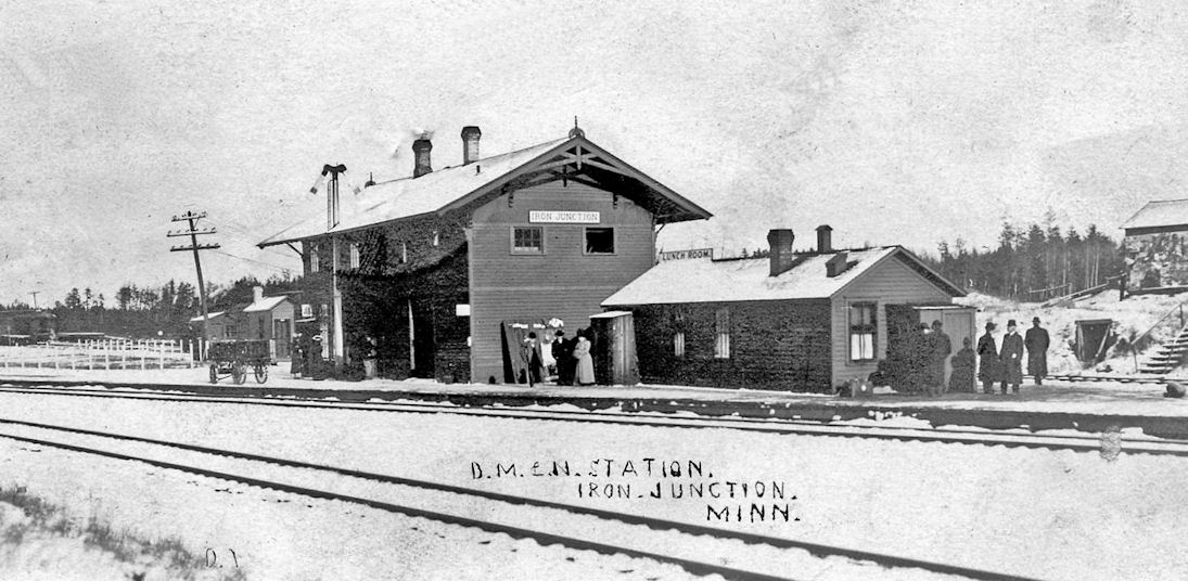
| Iron (Iron Jct.) |
|
|||||||
| Island |
|
According to the 1915 GN Valuations Records, a new station was built here in 1899 that measured 24'x24'. | ||||||
| Jones |
|
|||||||
| Keenan |
|
|||||||
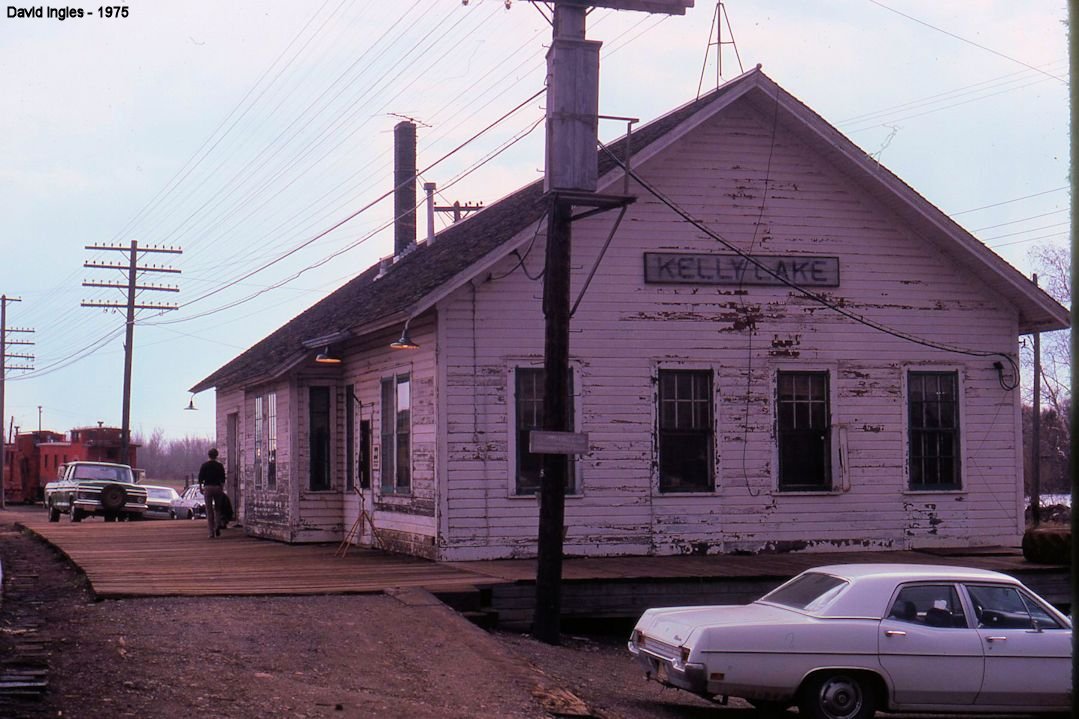
| Kelly Lake |
|
According to the 1915 GN Valuations Records, this station was built in 1905 and measured 30'x74'. | ||||||
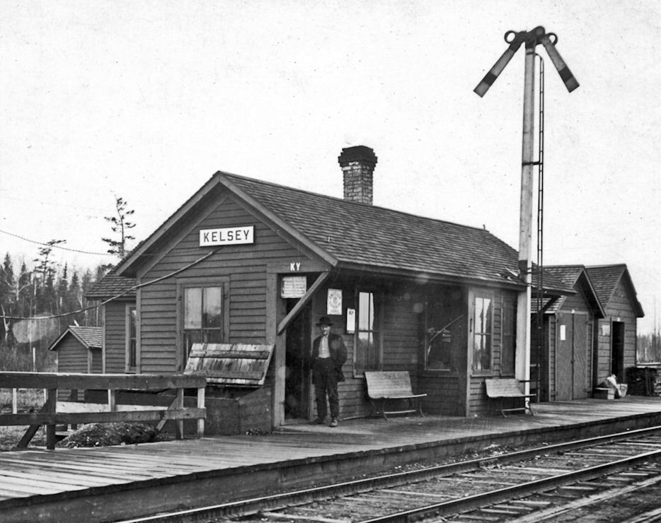
| Kelsey |
|
|||||||
| Kerr |
|
|||||||
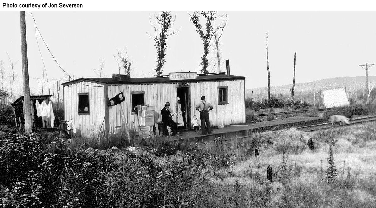
| Kinmount |
|
|||||||
| Kinross |
|
According to the 1915 GN Valuations Records, only a station sign remained at this location by then. It was abandoned by the GN as a station in 1921. | ||||||
| Kirk |
|
|||||||
| Kitzville |
|
|||||||
| Lakeside |
|
See entry below for Lester Park and the current station in Knife River (Lake County). | ||||||
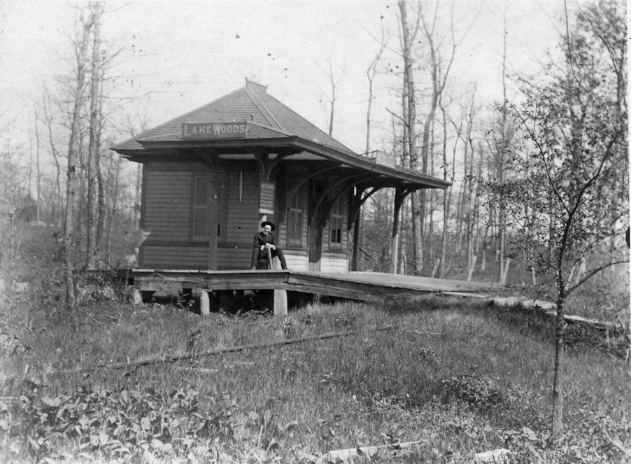
| Lakewoods |
|
Also known as Lakewood Station. According to the D&IR shareholders meeting minutes from 1914, money was allocated for the extension of this station. In 1916, money was allocated to move the station and platform (not sure how far) and put the station on a new foundation. There was a freight house here as well. | ||||||
| Lenont |
|
According to the D&IR annual meeting report of 1917, money was allocated for a new station at "Lenont" that year. I can find no other reference to that station on maps or timetables. Does anyone know where this was or if it ever got built? | ||||||
| Largo (Webster) |
|
This station was on the Eveleth-Virginia Branch between Leonidas and Rainey Junction. | ||||||
| Leander |
|
|||||||
| Leighton |
|
This station was in Township 56 North, Range 21 West, Section 9. It was abandoned by the GN in April 1929. | ||||||
| Leonidas |
|
This station was between Spruce and Largo Streets. | ||||||
| Lucknow |
|
According to the 1915 GN Valuations Records, there was only a platform and station sign here. The platform was built in 1910 and measured 11'x99'. | ||||||
| Lynwood (Stuart) |
|
This was in Township 56 North, Range 21 West, Section 29. According to the 1915 GN Valuations Records, there was only a station sign at this location as of that year. The name of the station was changed in December 1914. The station was abandoned by the GN in December 1940. | ||||||
| Macon |
|
Macon was west of Wolf on the NW side of Silver Lake. | ||||||
| Mahoning Spur |
|
According to the 1915 GN Valuations Records, a station was built here that measured 18'x42'. No build date was give. | ||||||
| Malden |
|
According to the 1915 GN Valuations Records, only a station sign remained at this location by then. It was abandoned by the GN as a station in 1925. | ||||||
| Maney |
|
|||||||
| Martins (Martin Siding) |
|
Both the Great Northern and the Duluth & Northeastern Railroad went through here. The DWP also had a station called "Martin Brothers Spur Station" here. | ||||||
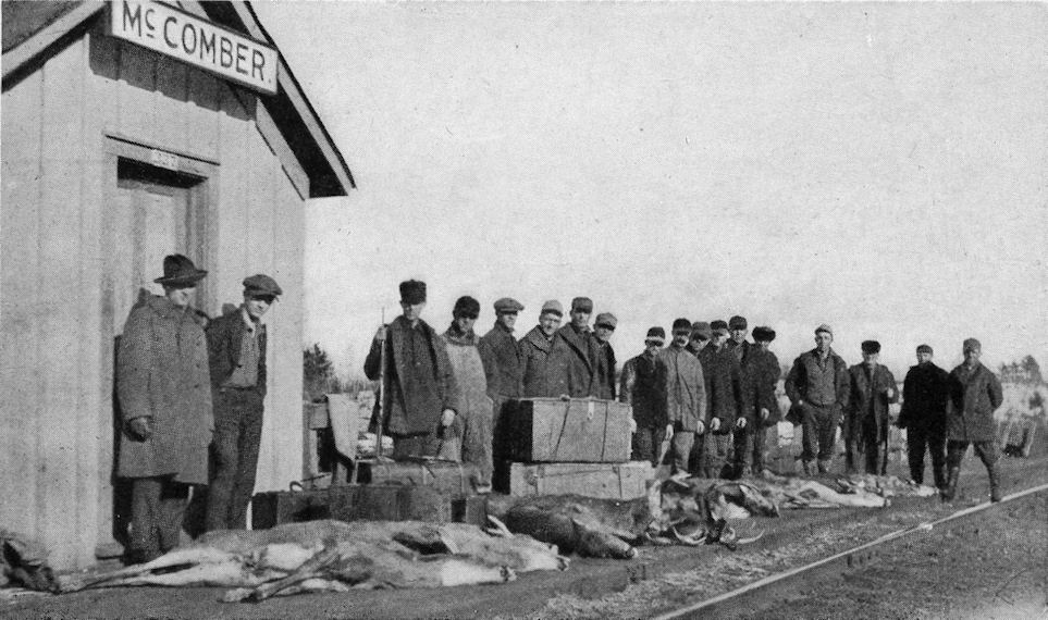
| Mc Comber |
|
|||||||
| Mc Comber (Vermillion Trail Lodge Station) |
|
There was a station in McComber itself and this one a few miles away at the Vermillion Trail Lodge. | ||||||
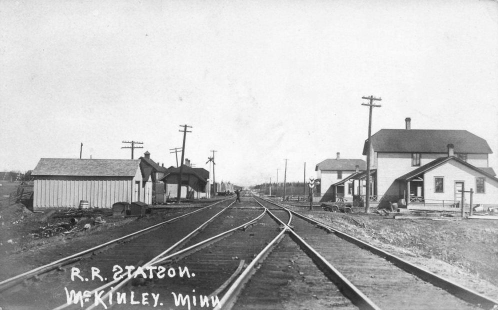
| Mc Kinley |
|
|||||||
| Meadowlands |
|
|||||||
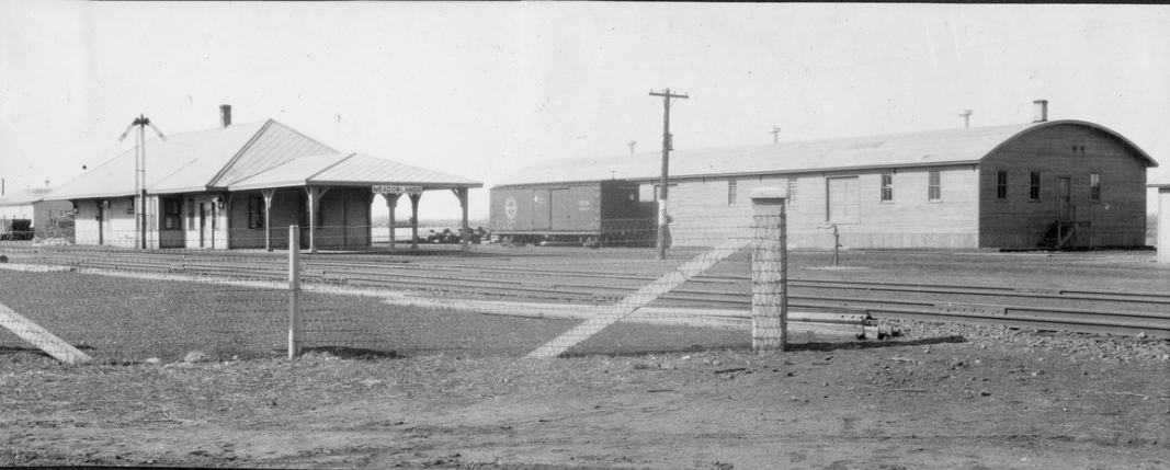
| Meadowlands |
|
This larger station replaced the one listed above. | ||||||
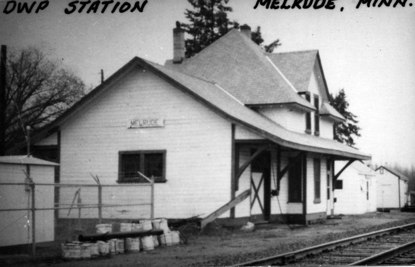
| Melrude (Ellsburg) (Ellsmere) |
|
This station was established as Ellsburg in 1910, the name was changed to Ellsmere in 1918 (although the post office remained as "Ellsburg" at that time). In 1927 both the station and post office were renamed "Melrude" after the town of "Mellerud" in Sweden. | ||||||
| MerritT |
|
Now part of Biwabik, this was on the western shore of Emabarrass Lake. | ||||||
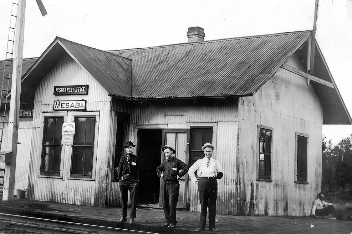
| Mesaba |
|
According to the D&IR shareholders meeting minutes from 1914, money was allocated for the extension of this station. | ||||||
| Mirbat (Gowan) |
|
This station was five miles southeast of Floodwood on the NE side of U.S. 2 near the intersection of Hingley Road. According to the 1915 GN Valuations Records, a new station was built here in 1899 that measured 24'x24'. The name of the station was changed from "Gowan" to "Mirbat" in December 1910. | ||||||
| Mitchell |
|
|||||||
| Morgan Park |
|
This station was on Spirit Lake, but was not the same as the Spirit Lake station (where there was just a passenger shelter) which was a mile away. According to the 1917 NP Valuation Records, a new 20'x68' combination station was built here in 1906. According to the book "Morgan Park, Duluth, US Steel and the Forging of a Company Town," by Arnold R Alanen, this station was demolished in 1925. It was primarily used by workers commuting between the Morgan Park steel plant and Duluth. It was located in the vicinity of GPS: 46.686164, -92.207244, next to the original LSM line. | ||||||
| Morgan park |
|
|||||||
| Mountain Iron |
|
|||||||
| Mountain Iron |
|
This station was on the south side of Main Street on the east side of the tracks at approximately GPS: 47.532232, -92.627309. | ||||||
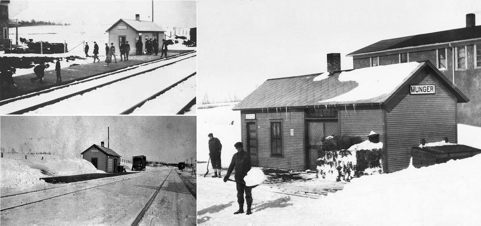
| Munger |
|
|||||||
| Munger |
|
|||||||
| Murphy (Murphy Spur) |
|
|||||||
| Murray |
|
|||||||
| Nagonab |
|
This station was between Draco and Cloquet on the St. Louis River on the south edge (Section 34) of Brevator Township. | ||||||
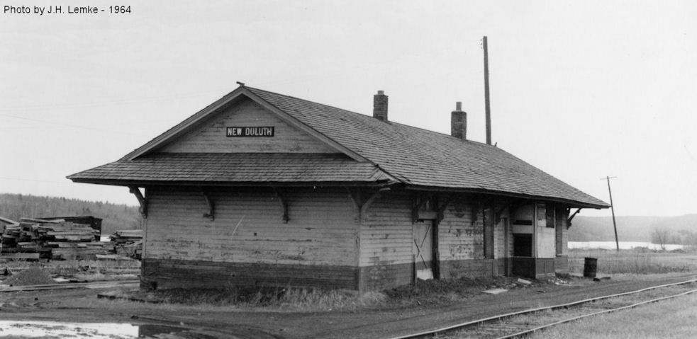
| New Duluth |
|
This station was on East Hudson Boulevard between Herman Avenue and Commonwealth Avenue at approximately GPS: 46.654380, -92.223433. According to the 1917 NP Valuation Records, a new combination station was built here in 1901 that measured 24'x73'. | ||||||
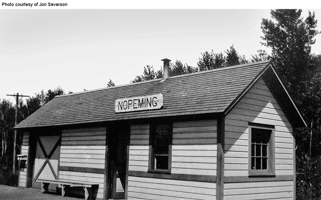
| Nopeming |
|
|||||||
| Nova (Bailey) |
|
This station's name was changed from "Bailey" to "Nova" on the GN in October 1916. It was abandoned as a station in 1925. Nova was in Section 19 of Mountian Iron Township (T. 58N, R. 18W). | ||||||
| Olcott (ElLis) |
|
According to the 1915 GN Valuations Records, the 24'x24' station at Riley was moved to Ellis in 1916. The station name at "Ellis" was then changed to "Olcott" in October 1916. The station was abandoned in 1925. | ||||||
| Onega |
|
|||||||
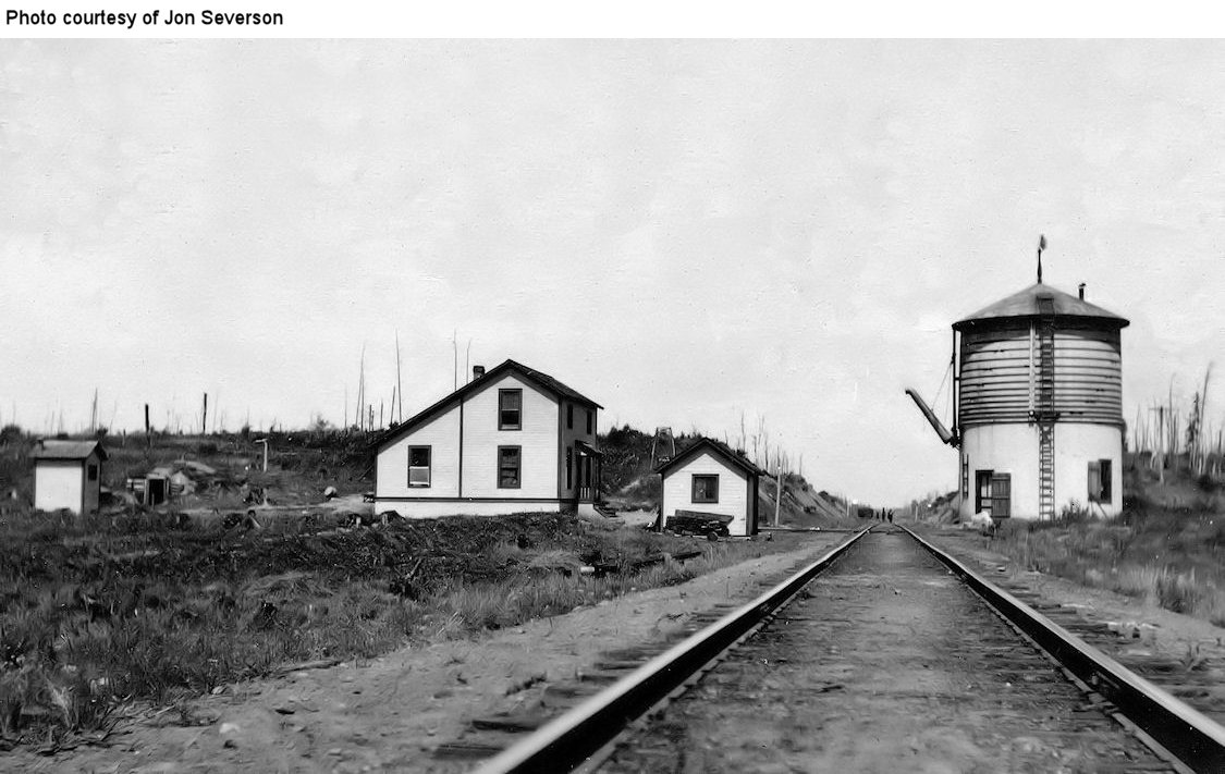
| Orr |
|
This was the first station built at Orr. | ||||||
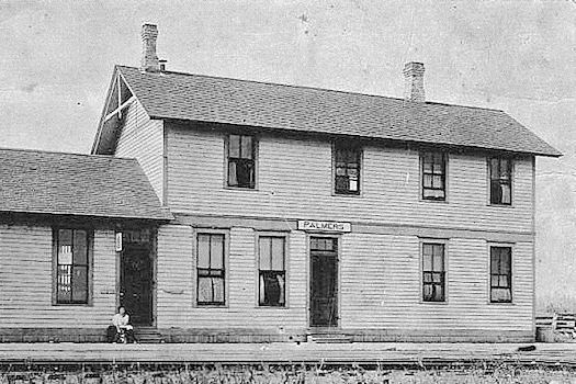
| Palmers |
|
According to the D&IR shareholders meeting minutes from 1916, money was allocated for a new freight house here in the amount of $475. | ||||||
| Para |
|
According to the 1915 GN Valuations Records, only a station sign remained at this location by then. It was abandoned by the GN as a station in 1925. | ||||||
| Paupores |
|
According to the 1915 GN Valuations Records, a new station was built here in 1911 that measured 12'x34'. | ||||||
| Payne |
|
There was a very small station here. | ||||||
| Payne |
|
|||||||
| Peary |
|
|||||||
| Pettit |
|
|||||||
| Pettit |
|
A station was built here on the DM&N when the tracks were moved around to make room for the open pit mines. | ||||||
| Proctor |
|
Formerly known as Proctor Knott, this station was built in 1906. In 1940 the second story was removed and a new roof was put on (Duluth News Tribune 8-14-1940). The station was on the south side of 2nd Street at GPS: 46.743541, -92.226691. | ||||||
| Prosit |
|
This station was in Section 10 of Alborn Township. | ||||||
| Putnam |
|
|||||||
| Rainy Junction |
|
This station was between Largo (Webster) and Virginia on the Eveleth-Virgina Branch. | ||||||
| Ramshaw |
|
This station was between Iron Junction and Spruce. | ||||||
| Reno |
|
|||||||
| Rice River |
|
This was the next station north of Britt. | ||||||
| Ridge |
|
According to D&IR annual meeting notes from 1912, an appropriation was made for the depot here in the amount of $179. It is not clear if this was for improvements or a new depot. If it was for a new depot, it would have been a small structure or repurposed carbody. | ||||||
| Riley |
|
According to the 1915 GN Valuations Records, the 24'x24' station at Riley was moved to Ellis in 1916. | ||||||
| Rivers |
|
|||||||
| Riverside |
|
This station was between Spring Street and Lenroot Avenue at approximately GPS: 46.706393, -92.206587. | ||||||
| Roberts Mine Spur Station |
|
|||||||
| Robinson |
|
According to the D&IR shareholders meeting minutes from 1914, money was allocated for a new station here at a cost of $1,800. | ||||||
| Rollins |
|
|||||||
| Ruby Junction |
AND |
The name of this station was changed on the GN in 1919 from DM&N Junction to Ruby Junction. | ||||||
| Saginaw |
|
The Duluth & Northeastern RR also ran through this town (north/south, with the DM&N running east/west). That line was removed in 1926 and probably did not have a station. | ||||||
| Sax (Wallace) (Arona) |
|
Some sources list these as two separate locations, but Sax (or Saxe) appears to be the current name of the location that used to be known as Wallace. Other sources show that station as being formerly named "Arona" or "Arona Saxe." GN records show the name change from "Saxe" to "Arona" in 1916. The station was abandoned by the railroad in 1925. | ||||||
| Scott Junction |
|
According to D&IR annual meeting notes from 1912, an appropriation was made for the depot here in the amount of $192. It is not clear if this was for improvements or a new depot. If it was for a new depot, it would have been a small structure or repurposed carbody. | ||||||
| Sharon |
|
See listing for Buhl above. | ||||||
| Sharon |
|
See listing for Buhl above. | ||||||
| Shaw |
|
|||||||
| Shenango |
|
This was two miles SE of Chisholm on the branch that ran from Wilpen to Chisholm. It served the Shenango Mine. According to the DM&N annual meeting reports, a new station was built here either in 1912 or 1913. | ||||||
| Sherwood |
|
|||||||
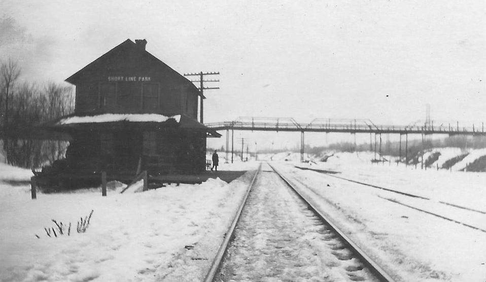
| Short Line Park (Braden) |
|
According to the NP Valuation Records of 1917, this two-story station was built in 1888 and measured 20'x22'. There was also a one-story 18'x16' freight house here. It was near where the Becks Road Bridge crosses the tracks today in the vicinity of GPS: 46.679420, -92.260669. | ||||||
| Silica |
|
|||||||
| Silver Lake |
|
This may be the same station that was also known as Macon (which was was west of Wolf on the NW side of Silver Lake). | ||||||
| Simar |
|
|||||||
| Sims |
|
This was in Township 56 North, Range 21 West, Section 16. | ||||||
| Skibo (Norman) |
|
This station was on Main Street. | ||||||
| Smithville |
|
According to the NP Valuation Records of 1917, there was only a passenger shelter here made out of an old RR car body. It was installed in 1909. There was likely a station building here prior to that. This station was between Short Line Park and West Duluth. The street names have changed here, but the station was likely on Clyde Avenue in the vicinity of GPS: 46.700890, -92.208600. | ||||||
| Soudan (Tower Jct.) |
|
|||||||
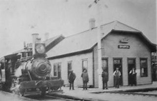
| Sparta |
|
This station was on the northwest corner of Genoa Avenue and Sixth Street. Around 1917 this station, and the main line tracks, were moved due to mine encroachment. | ||||||
| sparta |
|
This station was on the northeast corner of Dorr and Main Streets. Prior to about 1910 there were two depots in town, the D&IR to the north (listed above) and DM&N to the south. When the neighboring mines grew, they swallowed up the D&IR ROW, so they rebuilt to the south sharing the DM&N ROW. By the mid teens the entire town of Sparta was swallowed up by the mines. | ||||||
| Sparta |
AND |
After the town of Sparta was swallowed up by the mines, a small joint depot was built on the west side of the Genoa Pit. | ||||||
| Spirit Lake |
|
This station was between Riverside and Morgan Park. According to the 1917 NP Valuation Records, a new 12'x16' shelter-type station was built here in 1902. It was located just north of Clyde Avenue on the west side of the tracks at approximately GPS: 46.701210, -92.208093. | ||||||
| Spruce |
|
|||||||
| Steelton |
|
See entry for Gary (Steelton) above. | ||||||
| Summit |
|
|||||||
| Taber |
|
This station was six miles SE of Angora. | ||||||
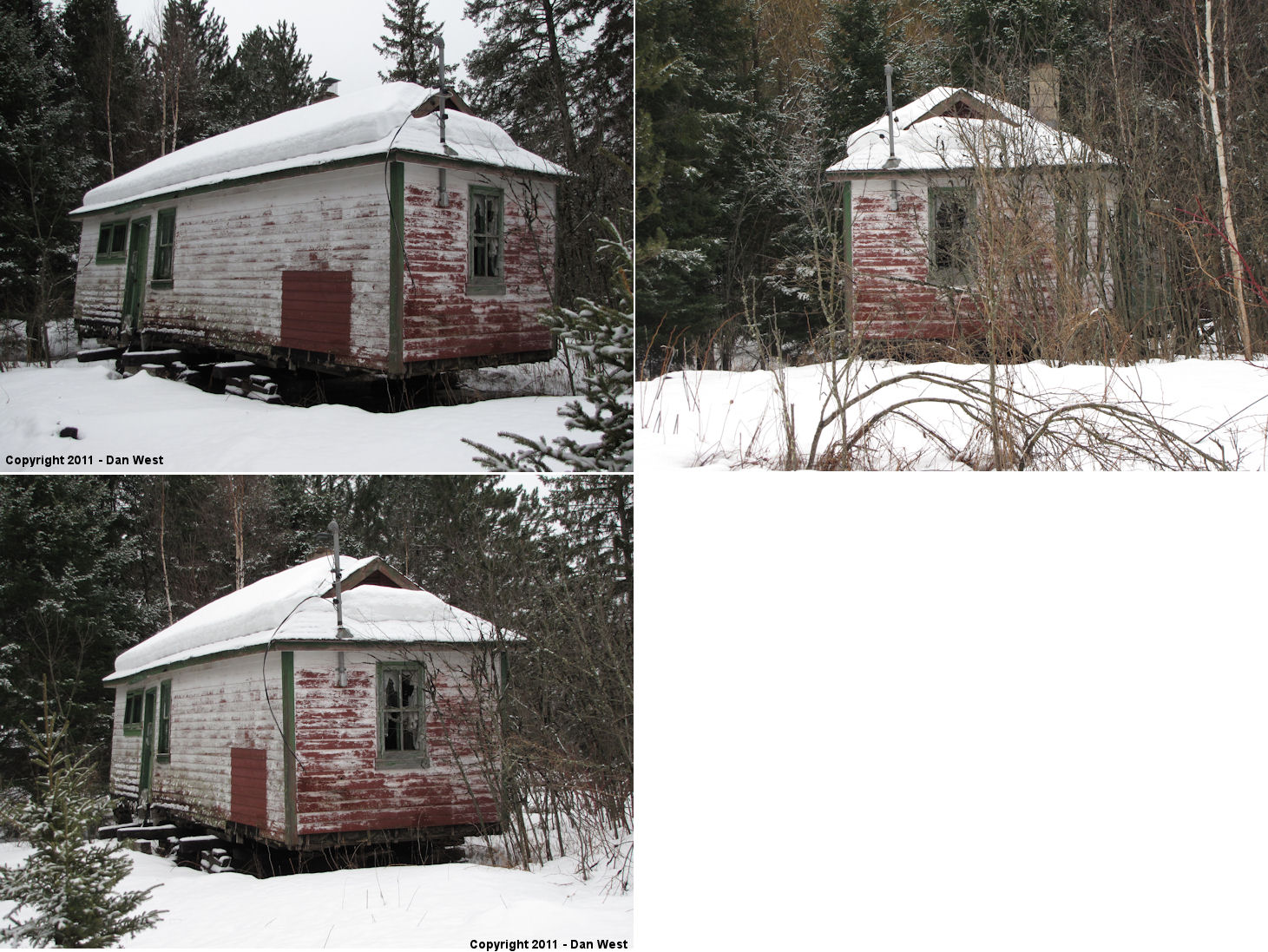
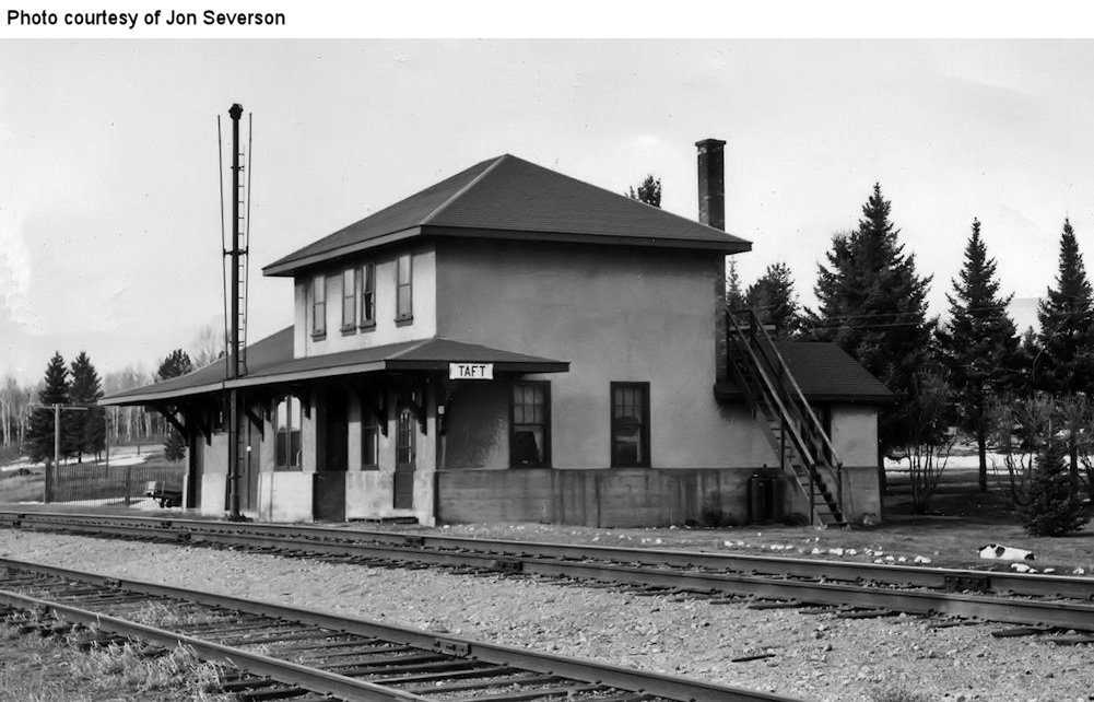
| Taft |
|
The original station. | ||||||
| Taft |
|
The newer station. | ||||||
| Toivola Station |
|
This station was at the west end of Arkola Road. According to the DM&N annual meeting records, a new station was built here in 1917. The station was on the Alborn Branch. | ||||||
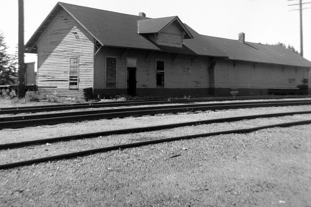
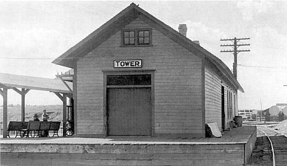
| Tower |
|
This was the first station at Tower, constructed in 1885. This was the first station built on the D&IR. It was on the south side of Main Street at Cedar at GPS: 47.805145, -92.280156. After the new station was built in 1915, this station served as a freight station and is shown as such on the 1921 Sanborn map. | ||||||
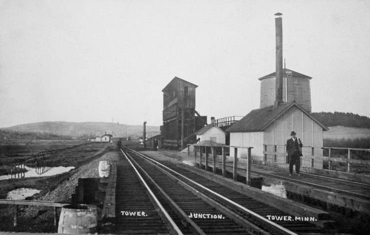
| Tower Junction |
|
The station may been the building in the distance on the left side of the photo. | ||||||
| Tudor (Ceylon) |
|
This station was in Section 15 of Payne Township. The name was changed from Ceylon to Tudor in 1905. The station was abandoned in 1924. | ||||||
| Turney (Hemlock) |
|
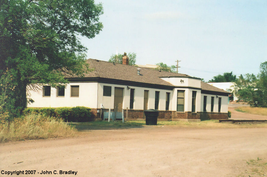
This station was also known as "Agnew," "Log Spur," and "Hemlock" over the years. It was in Section 9 of Alborn Township. | ||||||
| Twig |
|
|||||||
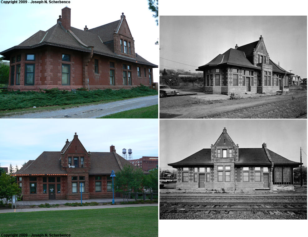
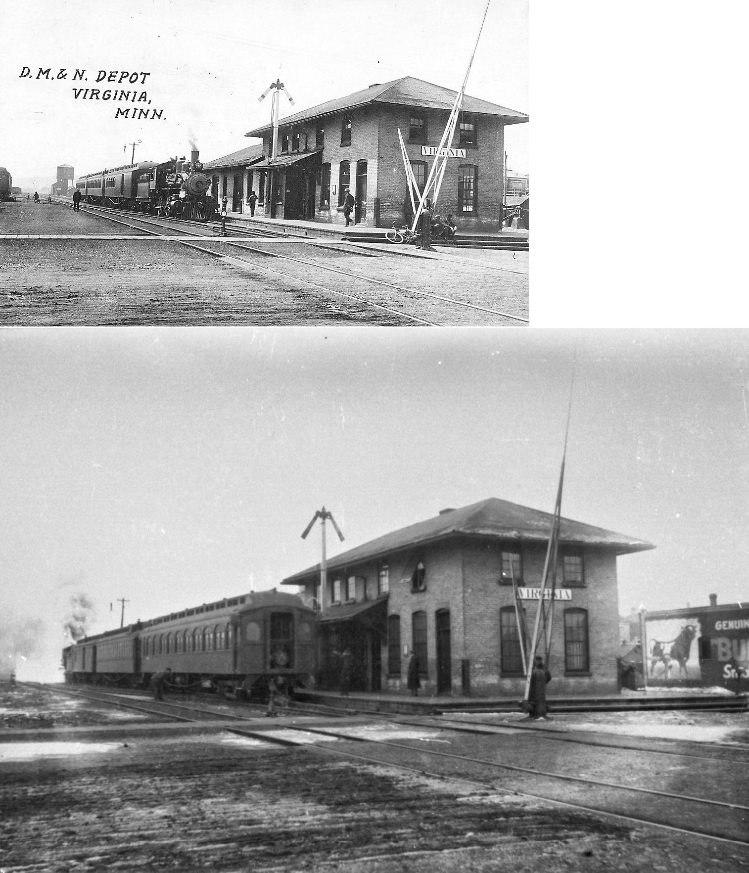
| Virginia |
|
According to the 1915 GN Valuations Records, a new station was built here in 1905 that measured 30'x88'. It was on the north side of 3rd Street North at North 5th Avenue West at GPS: 47.525910, -92.538937. This is now the site of the Beth Mesta Memorial Gardens. | ||||||
| Virginia |
|
This modern station was off 7th Street North at GPS: 47.528475, -92.544815 on GN's Aplena Spur. Depending on when it was built, this may have been a BN station. | ||||||
| Virginia |
|
The first station here was a two-story wood structure located on the southeast corner of Chestnut Street and 1st Avenue West at GPS: 47.523008, -92.531176. There was an original wood frame freight station here as well. Both the passenger and freight stations burned down in June 1900 when fire swept through the business district destroying 125 buildings. Two boxcars served as the station after that until the new brick station (see below) was built later in the same year. | ||||||
| Virginia |
|
This station, built in 1900, was on the southeast corner of Chestnut Street and 1st Avenue West at GPS: 47.523008, -92.531176. It was also used by the Duluth, Rainy Lake & Winnipeg RR (The Virginia Enterprise, 1-3-1908). At first the station was a combination passenger/freight depot, but later a standalone brick freight station (still standing) was built to the south in 1906. At the time the freight station was built, the passenger station was remodeled (Duluth News Tribune, 1-28-1906). | ||||||
| Virginia |
|
The freight house was at the SW corner of 4th Street North and North 6th Avenue West at GPS: 47.526783, -92.542384. This is now the location of Rotary Park. | ||||||
| Virginia |
|
According to D&IR annual meeting notes from 1913, an appropriation was made for an extention to the depot in the amount of $500. | ||||||
| Wahlsten |
|
|||||||
| Wallace |
|
|||||||
| Walsh |
|
This was two stations north of Wahlsten, between Rivers and Tower Junction. | ||||||
| Whiteface |
|
Also known as White Face River Station. | ||||||
| Wolf |
|
This station was built in 1910 (Duluth News Tribune, 5-8-1910). It replaced a depot that was called a "crackerbox" by The Virginia Enterprise (5-4-1910). | ||||||
| Wyman (Allen Station) |
|
Now called Wyman, this was previously known as Allen Station (which is different from, and north of Allen Junction) | ||||||
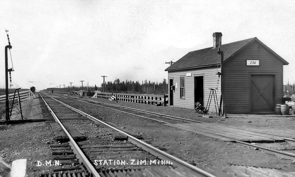
| Zim |
|
|||||||
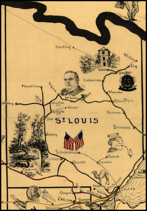
| 1898 ST. LOUIS COUNTY RAILROAD MAP | ||||||||
 |
||||||||
|
Notes About Existing Stations... Arbutus (DWP) - This station's original location was off Keyes Road in the vicinity of GPS: 48.306652, -93.048094. It was moved in 1970 to Highway 53 where it was remodeled as a house. Brookston (GN) - The 1915 GN Valuations Recordslist two build dates for this station: 1902 and 1911. This could mean that the station was built in 1902 and expanded or remodeled in 1911. The name was changed in 1902 from "Stoney Brook" to "Brookston." The record says it measured 24'x76'. Duluth (Union Station) - See the Duluth Depot site for more information. The train sheds were removed in 1924. Ely (D&IR) - The freight house was added on sometime between 1900 and 1906. Endion (DM&IR) - Added to the National Register of Historic Places in 1975. Moved from its former location at 400 South 15th Ave East (GPS: 46.799184, -92.076809) in 1985 due to the extension of Interstate 35. Fond Du Lac (LS&M) - According to a Duluth Herald article by Jack D. Shipley (published Jan. 6, 1981), this Lake Superior & Mississippi RR station was built in 1870 and was moved to 13308 West Third Street. It's not clear what its original location was, although it may have been at the site of the later NP depot (the LS&M was a predecessor of the NP) and could have been moved to make way for that station (which was just to the north of where the old station now sits). It served as a duplex and then became a restaurant around 1929. It is shown in a photo from 1904 (although that date is uncertain) and as a dwelling on the 1909 Sanborn map, so it was moved to that lot sometime prior. It served as The Olde Depot Inn restaurant from 1929 until 1985 and is now a house. Floodwood (GN) - According to the 1915 GN Valuations Records, a new station was built here in 1890 and was remodeled in 1911. It measured 16'x94'. So, it is likely that this is the original station with an addition and a facelift. Its original location was on the south side of Railroad Street between 6th and 7th Avenues at GPS: 46.927547, -92.918449. Hibbing (GN) - Originally known as "Alice," when the original town of Hibbing moved south, this station was then known as "South Hibbing" on the GN from 1919 to 1941. The railroad officially changed the station name to just "Hibbing" on Dec. 15, 1941. Iron Junction (DM&N) - Bought by the Iron Range Retriever Club about 1950 and moved to its current site at the Ben Niemi Field Trial Grounds. Taft (DW&P) - I could not confirm that this was the station. Building is up on blocks having been moved to this lot from elsewhere. It is not far from where the Taft station would have been, however it does not match the two older photos of Taft stations listed below in the "Stations Of The Past" table so it is most likely not from here. Does anyone know for sure if this was a station or something else? If it was station, where is it from? --Dan West Twig (DW&P) - I am not convinced that this was a station as it looks like a modern building. It appears to be used as some sort of chemical loading facility. Does anyone know for sure if this was a station? --Dan West Virginia (DW&P) - The first building to occupy this site was a library that was built in 1905. The city built a new library in 1913 and sold the building to the railroad. The CN railroad moved the library building and built the Duluth, Winnipeg, and Pacific Railway station on the site. The depot was used by the railroad until the late 1950's when it was converted to a bank. Virginia (DM&N Freight) - This freight station was built at the east end of 1st Street South (formerly Maple Street) at 1st Avenue West (formerly Railroad Street) sometime between 1904 and 1907. It was lenghtened in 1910. The building is made of brick, but is now mostly covered in aluminum siding. Wilpen (DM&IR) - This station was moved from Wilpen to Chisholm and is now labeled "Glen" depot. Some sources say the station was built in 1915, but according to DM&N annual meeting records, the contract to build the station was entered into in 1910, so the build date might be earlier than 1915. |
||||||||