 COUNTYCOUNTY
|
|
||||||||
| EXISTING STATIONS | ||||||||
|---|---|---|---|---|---|---|---|---|
| Station Name |
Original Railroad | Current Location |
Type | Date Built |
Current Use |
Track Status |
Building Material |
More Info |
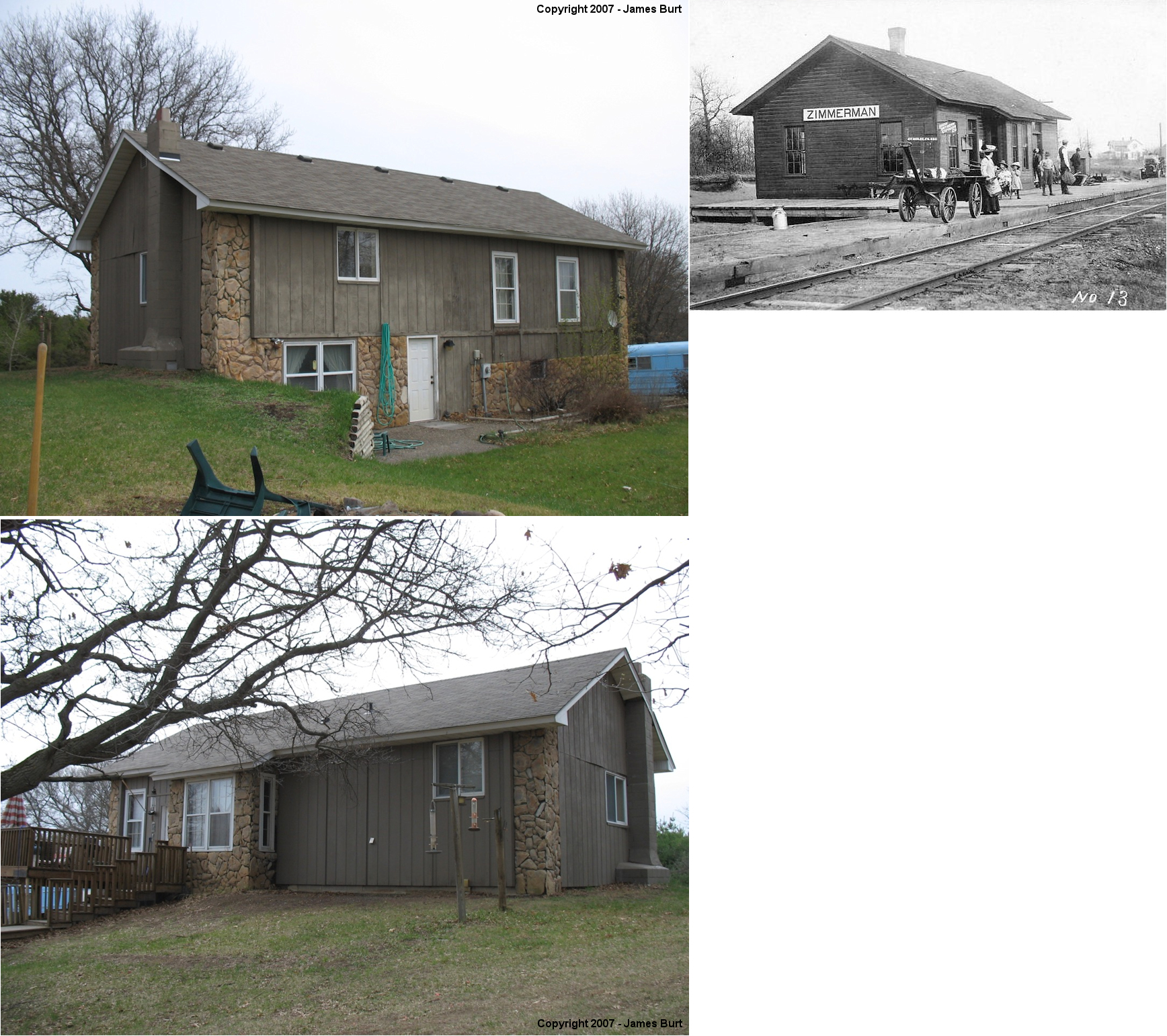
| zimmerman (Lake Fremont) |
 |
South end of Rochester Street NE, Isanti (GPS: 45.450882, -93.211072 ) |
C | 1903 | Residence | None | Wood |
|
| STATIONS OF THE PAST | ||||||||
| Station Name |
Original Railroad |
Notes | ||||||
| Bailey Siding (Baileys) |
|
A new station was built here in 1907 that measured 20'x32'. The GN abandoned its station here in June 1948. | ||||||
| Baileys (Humboldt) |
 |
The NP station here was built in 1892 and measured 10'x12'. | ||||||
| Becker |
|
The GN and NP stations sat a few feet away from each other between Hancock and Willow Streets. The tracks ran parallel here with the GN on the "outside" in respect to the location of the town. | ||||||
| Becker |
|
The station pictured is the second generation NP depot at that location which was built in 1915 and measured 28'x80' with a covered platform. According to the 1915 GN Valuation Records, the GN only owned a platform here between the tracks, so it likely used the NP station in later years. | ||||||
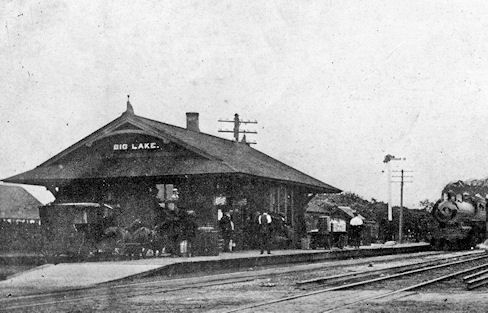
| Big Lake (Elk Prairie) |
|
This was the original GN station. See below. | ||||||
| big lake |
|
In later years the railroads shared a station, but according to the 1903 map of the town GN and NP had separate stations (the map probably lagged in time a bit since a new station was built in 1902. They were essentially next to each other on the east side of Lake Street South. The NP tracks were north of the GN tracks. According to the 1915 GN Valuation Records, the GN only owned a platform here between the tracks, so it likely used the NP station. According to the 1917 NP Valuation Records, a new station was built here in 1902 that measured 24'x42'. That station burned down in 1924 and the one listed below was built. | ||||||
| Big Lake |
AND |
Built in 1924, this station was torn down in 1969. Used by both railroads, it was owned by the NP. | ||||||
| Cable (Haven) |
|
This location was known as Haven Station on the GN until December 1914 when it was changed to "Cable." It was abandoned in 1940. | ||||||
| Cable |
|
The NP Valuation Records of 1917 only list a telegraph office for this location. It is unclear if there was a station here prior to that. | ||||||
| Clear lake |
|
The Clear Lake GN and NP stations were next to each other on the SE side of Center Street (not sure which street this is now as the names have all changed). | ||||||
| Clear Lake |
|
Note the similarity in design between this station and the Big Lake station. This station also measured 40'x42' and was built in 1905. | ||||||
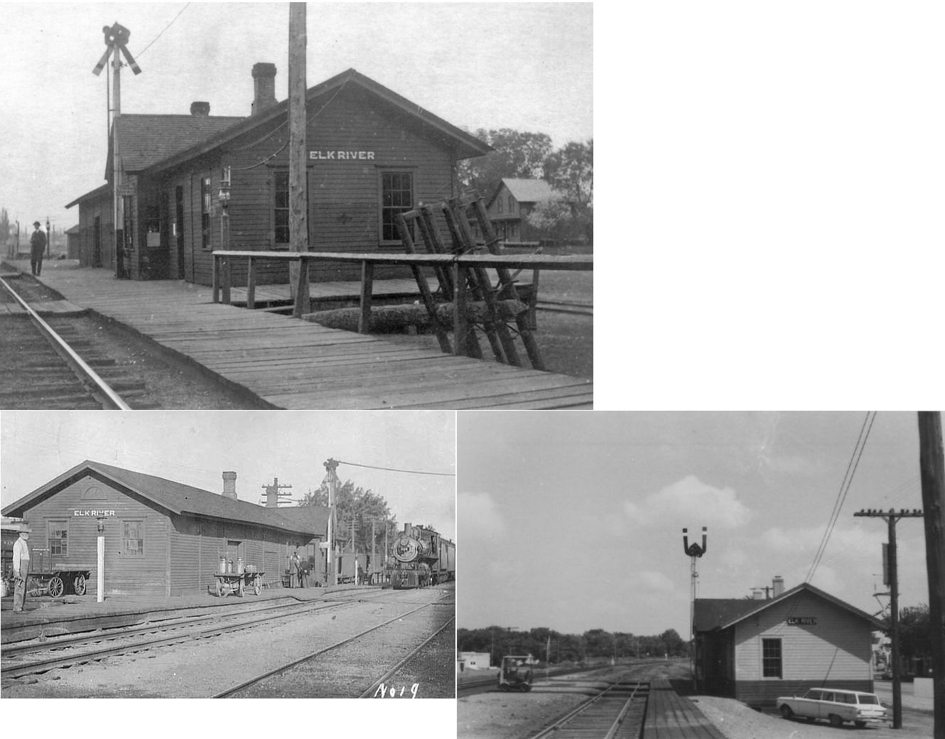
| Elk River |
AND |
This combination station was near the intersection of US-10 and Norfolk Street, although there is not through street to the tracks here anymore. According to the 1915 GN Valuation Records, the station here measured 20'x100'. Sometime between 1905 and 1911 this became a shared station with the NP. | ||||||
| Elk River |
|
This original combination station was east of Proctor Avenue NW near where 6th Street used to cross the tracks. It was built in 1892 and measured 24'x100'. Sometime between 1905 and 1911 it became a freight-only station as passenger operations moved to the GN depot. | ||||||
| Fitzpatrick |
|
This station was located six miles north of Elk River on the east side of Section 33 in Livonia Township. It was likely gone by the early 1900s. | ||||||
| Houlton Siding |
|
This station was located three miles north of Elk River in the west central part of Section 16, Elk River Township. The county map from 1903 shows a spur here with several buildings around it. This property, and quite a bit in and around Elk River, was owned by William Henry Houlton (1840-1915) who had a lumber, flour and mercantile business along with his brother Horatio. Not sure if there was a passenger station here, but there was likely at least a freight station. | ||||||
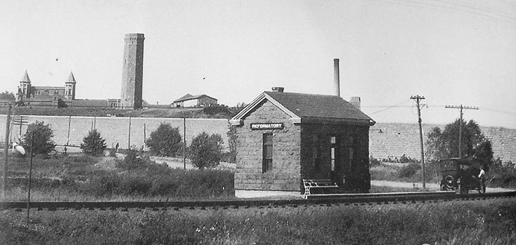
| Reformatory |
|
According to the 1915 GN Valuation Records, the station here was built in 1908. It was made of granite with a concrete foundation and measured 14'x18'. It was torn down in 1939 (St. Cloud Times, 10-25-1939). | ||||||
| Salida (Akron) |
|
According to the 1915 GN Valuation Records, the station here measured only 10'x12'. It was abandoned by the GN in December 1937. | ||||||
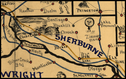
| 1898 SHERBURNE COUNTY RAILROAD MAP | ||||||||
 |
||||||||
|
Notes About Existing Stations... Zimmerman (GN) - Although the map above depicts Zimmerman and Lake Fremont as separate locations, they were essentially the same town and thus only had one station. The area where the station was has now been redeveloped, but the station originally was located along what is now Gateway Drive near where that street bends from east/west to north/south. The structure is now virtually unrecognizeable as a depot after heavy modifications. According to the GN Valuation records of 1915, the station measured 24'x48'. |
||||||||