 COUNTYCOUNTY
|
|
||||||||
| EXISTING STATIONS | ||||||||
|---|---|---|---|---|---|---|---|---|
| Station Name |
Original Railroad | Current Location |
Type | Date Built |
Current Use |
Track Status |
Building Material |
More Info |
|
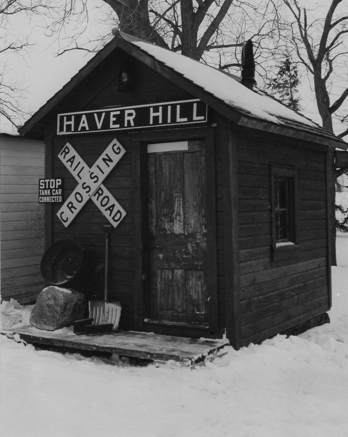
Chester (Haverhill) |
 |
70th Avenue NE (GPS: 44.052557, -92.339547) |
P | ???? | Private | None | Wood |
|
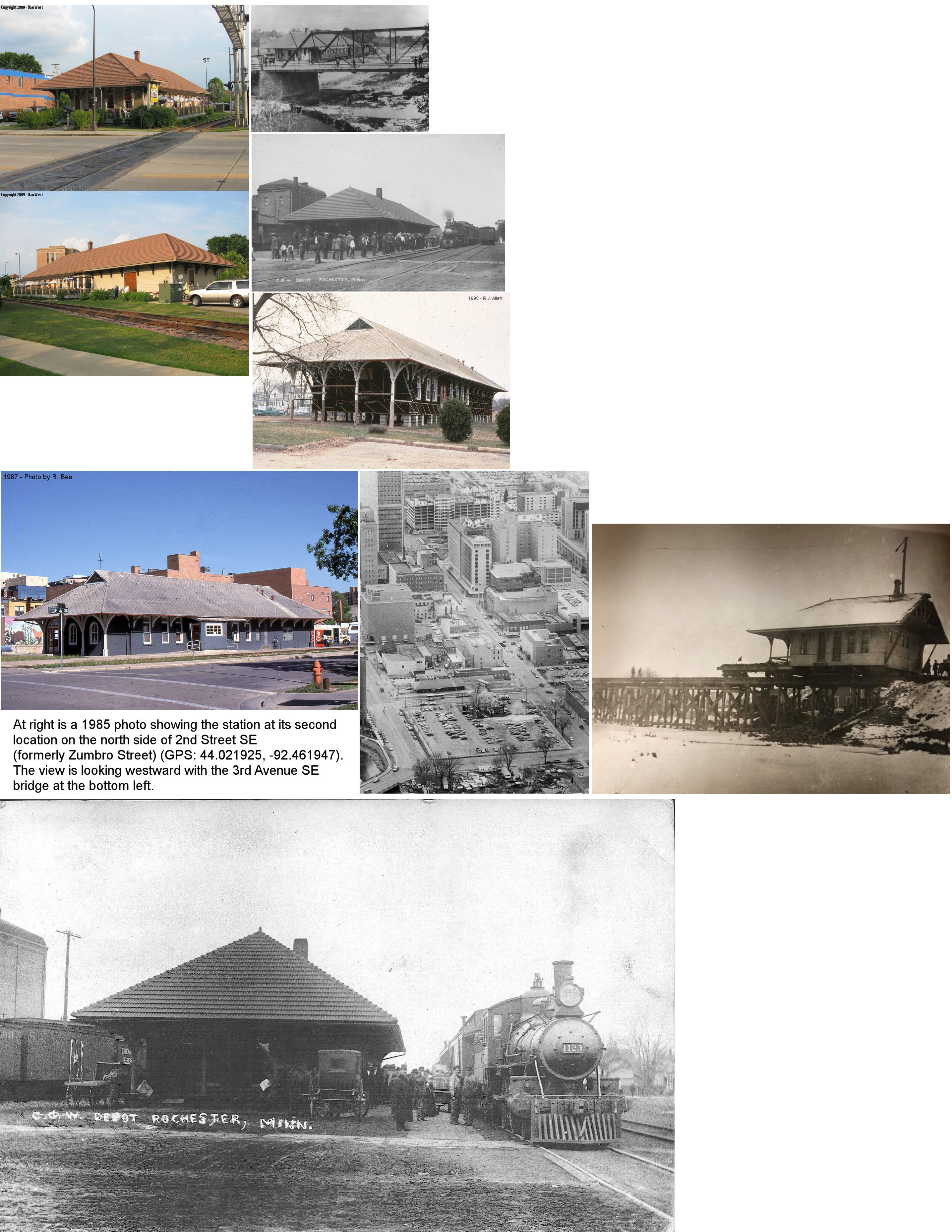
| Rochester |
 |
4th Street SE (GPS: 44.019023, -92.461369) |
P | 1899 | Restaurant | In Use | Wood |
|
| STATIONS OF THE PAST | ||||||||
| Station Name |
Original Railroad |
Notes | ||||||
| Byron (Bear Grove) |
|
The station was on the west side of Tremain Street (now called Byron Street after all original names were stripped from the streets). The C&NW built a station here in 1883. | ||||||
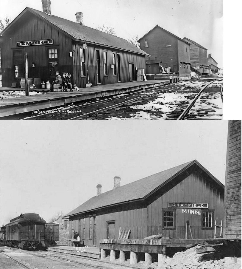
| Chatfield |
 |
This station, built in 1878, was at the end of Bench Street near the intersection with Spring Street (GPS: 43.845852, -92.192546). This intersection no longer exists as Bench Street now ends at 1st Street SW and Spring Street ends at Twilford Street. The station was also accessible from a short driveway (called Depot Road on Sanborn maps) from Twilford Street. This station was just south of the county line in Fillmore County. | ||||||
| Chatfield Junction (PLainview JCT.) |
|
This station was just west of Eyota in the vicinity of GPS: 43.992363, -92.248736. | ||||||
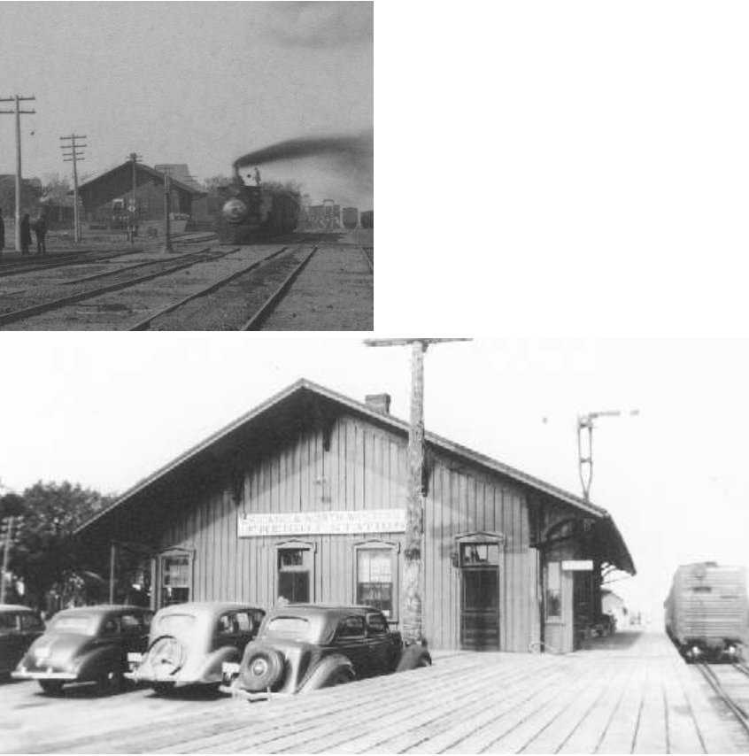
| Chester (Haverhill) |
|
This station was located on the west side of Chester Avenue SE (county Road 119) on the south side of the tracks. The name was changed from "Chester" to "Haverhill" in 1914 to avoid confusion between "Chester" and "Rochester," even though it is south of Haverhill Township in Marion Township. According to the C&NW valuation file of 1919, the station was built in 1871 and measured 16'x26'. Other names used for this station in the early days of the railroad included "Sherman" (1866) and "Zumbro" (1865). | ||||||
| Corra |
 |
In 1896 this station was located on the property of Thomas Malthieson. This location today is in northern Viola Township, about 200 yards north of CR 24 where the old RR grade crosses. An old trestle still exists near where this station used to sit. This station survived at least into the CN&W era as it is shown on 1896 maps. | ||||||
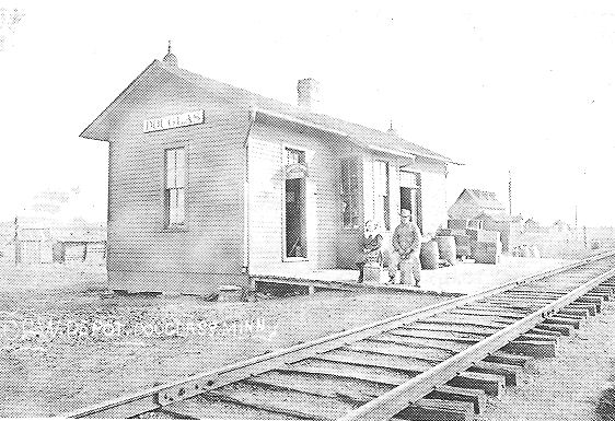
| Douglass |
 |
The first station here was built in 1878 on land owned by Harrison Douglas. It was on the SW corner of Hunter and Jones Streets. This was about 1/2 mile south of where 75th Street is today. The R&NM later became part of the C&NW. Spelled alternately as "Douglas" on some maps, the name with the double "s" is correct. | ||||||
| Douglass |
 |
This combination station was 1/2 block south of Main Street. There was a cheese factory just south of this station. It was retired in 1956 and torn down. | ||||||
| Doty Station |
|
This station was on the property of Edwin A. Doty on the southern border of Viola Township. This location is now just north of CR 9 just west of MN 42. This station survived at least into the CN&W era as it is shown on 1896 maps. | ||||||
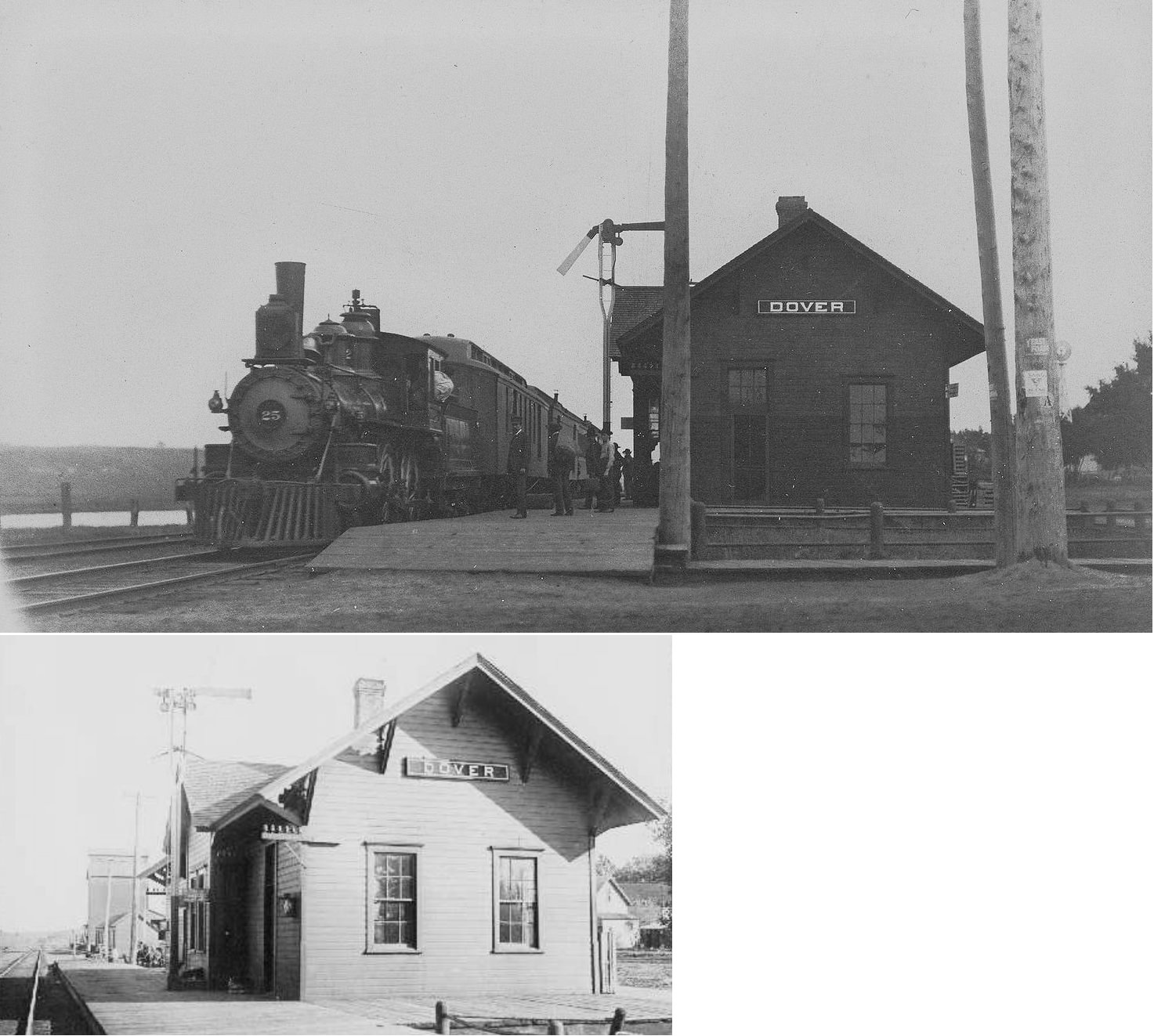
| Dover |
|
The first station here was built in 1869, a couple of years after the Winona & St. Peter was taken over by the C&NW. In 1896, the station was on the east side of North Chatfield Street, on the south side of the tracks. There was a hotel just south of the station. A new station was built here in 1895. | ||||||
| Dover (Dover Center) |
|
This two-story brick station was on the SE corner of Chatfield Street and Center Street. The station was on the south side of the tracks. It was built in 1890. The CGW accessed this station via the CNW after part of the CGW's Winona line was abandoned. It was closed in 1956. | ||||||
| Eyota |
|
The first station here was built in 1864. The station was located on the west side of Center Street, just north of Front Street South. | ||||||
| Eyota |
|
In 1879 separate passenger and freight stations were built here by the C&NW. This second generation station was at the same loaction as the first station; on the west side of Center Street on the north side of Front Street at GPS: 43.988931, -92.229377. The freight station was razed in 1962 and replaced with a fertilizer warehouse (the freight station had been used for that purpose for several years prior with the RR leasing it to the fertilizer company and lumber companies prior to that) (Winona Daily News, 8-29-1962). The passenger station was likely torn down around 1967 as the railroad brought in a special trailer in the summer of 1967 to be used as a depot around that time. When the trailer was brought in, the old depot was still standing (Winona Daily News, 7-21-1967). Near the end of service in the late 60s, the Eyota depot (and subsequent trailer) handled business for St. Charles, Lewiston, Dover, Plainview, and Utica as those stations were phased out. | ||||||
| Haverhill |
|
See entry for Chester above. | ||||||
| Horton (Racine) |
|
This station was in the NW corner of Section 34 of Eyota Township. It was named for Charles Horton, a lumber dealer from Winona. After the station in Racine burned down, this station was moved there in 1911 and a freight room was added. The photo shows the station after it was moved to Racine. | ||||||
| Laird |
|
This 18'x30' station was in Section 26 of Eyota Township. | ||||||
| Judge |
|
The station was on the farm owned by Edward Judge. A cold storage room was added to the depot in 1904 and the station was closed in 1936. | ||||||
| Olmsted |
|
This station was 4.5 miles west of Rochester on the boundary line between Kalmar and cascade Townships. It was on the farm of J.V. Matthews, which was roughly on the NW side of the intersection of 60th Ave NW (CR 104) and US 14 West. | ||||||
| Oronoco Switch |
AND |
The tracks of the CGW and C&NW ran parallel through here from Rochster to Zumbrota. Also known as Oronoco Station. Sometime after the original stations of both lines either burned (as was the case with C&NW predacessor R&NM) or went out of service, it appears that two old boxcars were used as the station (maybe one for each RR line). The location of these stations is inaccessible by road today (although you can use the bike path on the former right of way to get there. It was located between what today is New Haven Road NW and CR 31, approximately 1/2 mile south of 117th Street NW. The station was retired by the CGW in 1940 (Chicago Great Western: Depots Along The Cornbelt Route, 2004). The two old boxcars were subsequently moved to a farm (owned by Herb & Dorothy Bertschinger) about a mile away where a connecting roof was built between them to make a tractor storage shed. | ||||||
| Oronoco Switch |
 |
The Wisconsin, Minnesota & Pacific was first to build a station here. This RR was later part of the CGW. | ||||||
| Oronoco Switch |
|
There was a small frame depot here, but it burned down in 1898 after sitting empty for 6 years (The Record & Union, 10-14-1898). It may have been that the old boxcars were installed as the station(s) here after that. | ||||||
| Plainview Junction |
|
See listing for Chatfield Junction above. | ||||||
| Planks Crossing |
 |
This station was a boxcar without wheels. It was on the southern border of Eyota Township (Section 34) between Eyota and Chatfield. | ||||||
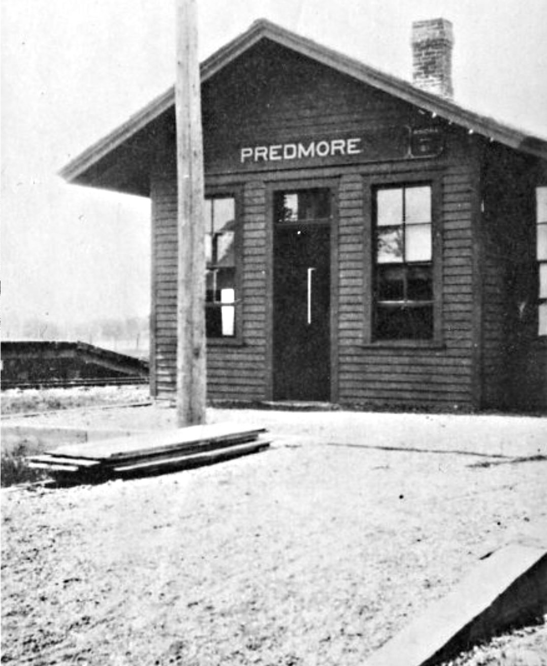
| Predmore |
 |
The first station here was built in 1891. This railroad was later absorbed by the CGW. There may have been a second-generation depot here or the original one may have served the entire time. There was also a small stockyard here. The station was retired by the RR in 1949. | ||||||
| Rochester |
|
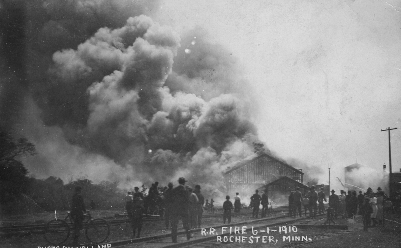
The original wood frame combination station was on the west side of 1st Avenue NW (formerly Main Street) at GPS: 44.027091, -92.465059. It was built in 1865 by the Winona & St. Peter. It was heavily damaged by the 1883 tornado, but was repaired and remained in service. When the new station (listed below) was built, it served as a freight station until it burned down in 1910. | ||||||
| Rochester |
|
This station was at 320 1st Avenue NW (on the east side of 1st Avenue NW on the south side of the tracks) (GPS: 44.026814, -92.464021). The 1954 Rochester City Directory lists the station at 321 North Broadway. It was built in 1895 (some sources say 1890, but it was not on the Sanborn map for that year), and was remodeled in 1908. It was closed by the railroad in 1957 and then served as the Depot House restaurant from 1967-1979 and later housed the Salvation Army. It was demolished in 1989 with the construction of Civic Center Drive. The uptown ticket office was at the Kahler Hotel. | ||||||
| rochester |
|
This freight station was at 321 2nd Avenue NW (to the NE of the former intersection of 3rd Avenue and 4th Street) (GPS: 44.027620, -92.467456). Other sources say the address was 401 2nd Avenue (essentially the same location as above) (Rochester Post-Bulletin, 8-28-1968). It was built to replace the freight station (original combination station) that burned down in 1910. | ||||||
| Rochester |
|
There was a wood-frame freight station on the south side of 1st Street SE at GPS: 44.022291, -92.462124. This is shown on Sanborn maps from 1904-1928. | ||||||
| Rochester |
|
A new brick freight station was built at 12 1st Street SE (on the south side of 1st Street SE) at GPS: 44.022291, -92.462124. This was essentially the same site of the previous wood freight station. The new station was likely built in the 1930s. | ||||||
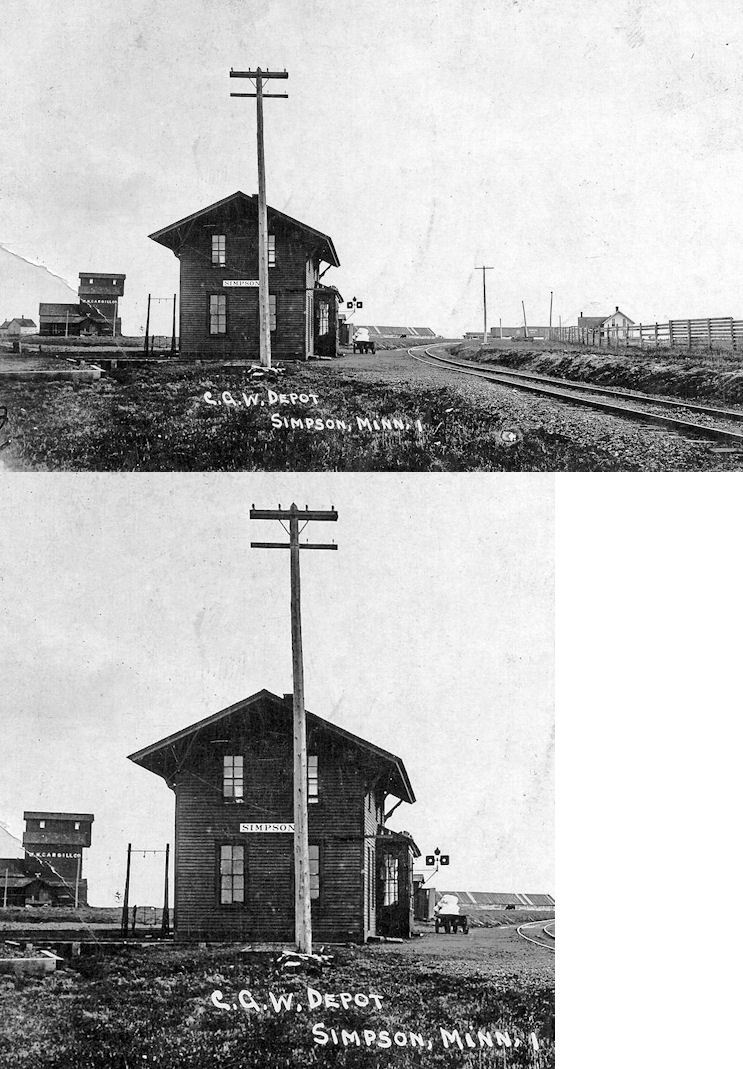
| Simpson |
|
The town and station were named after the secretary of the Winona & Southwestern RR. This two-story depot was originally on the east side of Main Street, just north of Church Street in the vicinity of GPS: 43.923868, -92.412517. These street names no longer exist here. The second floor of the station was the agent's residence. The station was likely moved when the wye was put in so the depot would have been at the covergence of the wye on the NW side at approximately GPS: 43.924907, -92.414105. The station was demolished in 1950. | ||||||
| Simpson |
|
After 1950 this small shack was used as the station here for a short time until passenger service ended, but saw more action as a switch shack. | ||||||
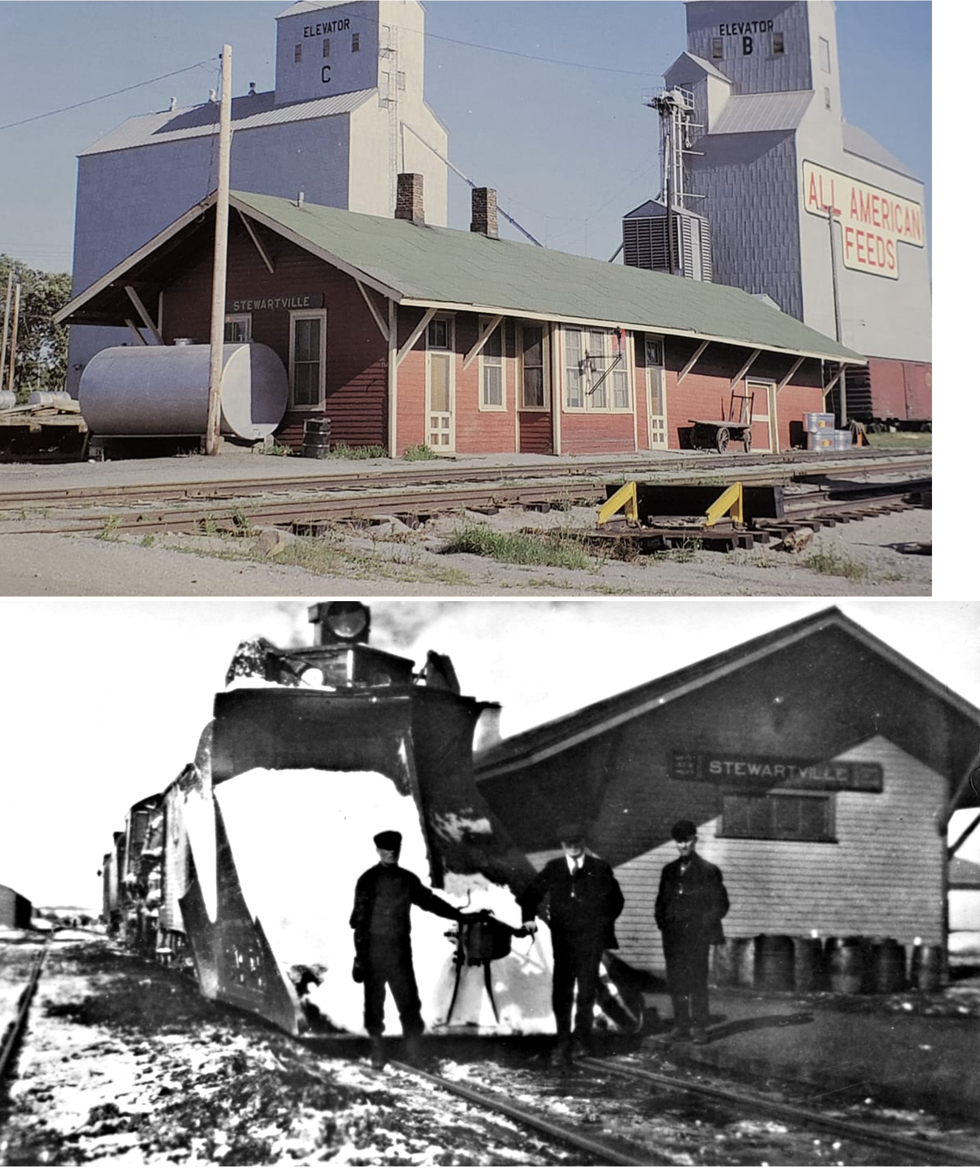
| Stewartville |
|
The first depot here was a converted boxcar placed by the Winona & South Western in November, 1890. | ||||||
| Stewartville |
|
The first permanent station here was on the south side of Broad Street just west of 2nd Street at approximately GPS: 43.852231, -92.485529. It was built in 1900 to replace the boxcar station. This station burned down in October 1915 and was replaced by the one listed below. | ||||||
| Stewartville |
|
This station, built in 1916, was on the south side of Broad Street just west of 2nd Street at approximately GPS: 43.852231, -92.485529. It was torn down in 1972. | ||||||
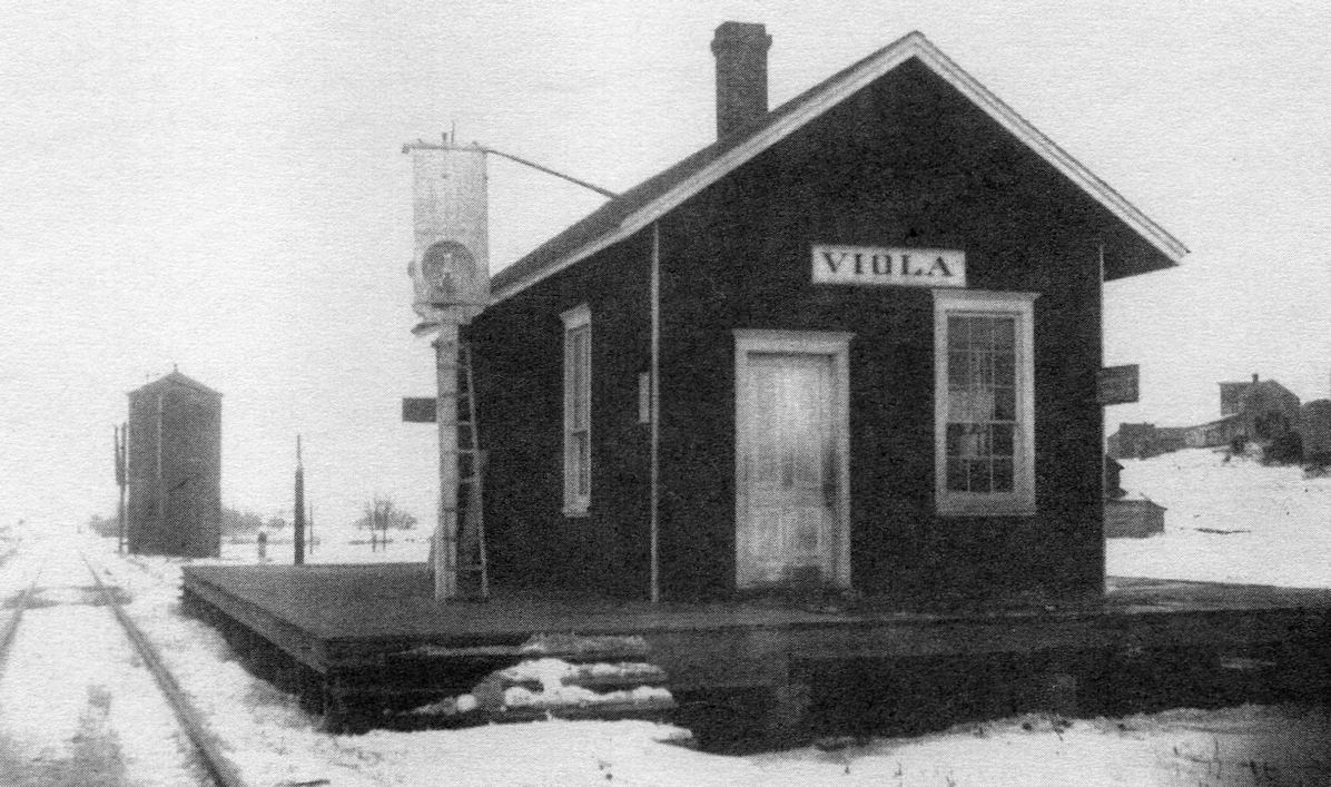
| Viola |
|
This station was on the SW corner of Market and Park Streets. A later C&NW station was built here in 1898 which was in the 3200 block of Market Street NE. Tracks were removed in 1997 and right-of-way is now a bike trail. | ||||||
| Zumbrota Junction |
|
This station was located in section 34 of Cascade Township. | ||||||
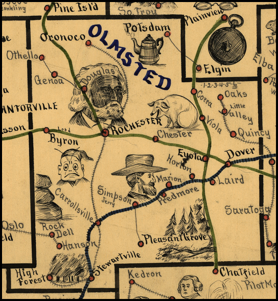
| 1898 oLMSTED COUNTY RAILROAD MAP | ||||||||
 |
||||||||
|
Notes About Existing Stations... Chester (Winona & St. Peter) - This small passenger shed replaced a larger, earlier station. The original location was on the west side of Chester Avenue SE (county Road 119) on the south side of the tracks. The name was changed from "Chester" to "Haverhill" in 1914 to avoid confusion between "Chester" and "Rochester," even though it is south of Haverhill Township in Marion Township. Rochester (Winona & Western) - The Winona & Western Railway depot was originally located on the south side of College Street (now 4th Street SE) on the east side of the tracks by the Zumbro River (GPS: 44.019023, -92.461369). It's second location was at 21 2nd Street SE (on the north side of 2nd Street SE, formerly Zumbro Street) (GPS:44.021925, -92.461947). The Chicago Great Western Railroad bought the Winona & Western Railway in 1901. In January of 1903, the depot was cut in two and moved across the river. The Sanborn map from 1904 however shows a very small station on the north side of 2nd Street SE and no station on the south side of College Street. Next to the illustration of the small station is the note, "to have new depot." The 1909 map shows the small station gone and the existing station now in its place. It was moved to its current location on 4th Street SE in 1993. Cindy Scott of the History Center of Olmsted County describes it's lifecycle like this: "In 1899, Winona & Southwestern Railroad constructed a wood-frame depot and freight house at the intersection of [now] 1st Ave. and 2nd St. SE. Two years later the line was sold to Chicago Great Western RR who moved the building north across the river in 1903 by cutting it in two, placing each half on a flat rail car, and reassembling it at 19 2nd St. SE. The book "Chicago Great Western: Depots Along The Cornbelt Route" (2004) say that the station was "Ccut in half and moved uptown in 1903, the waiting room was placed on the north side of Second Street and the freight room on the south side. This proved impractical due to the small size of the waiting room so the freight room was moved across the street and the depot was remodeled in 1904." In 1949, the structure was remodeled to serve as a terminal for Jefferson Bus Lines as well. The last passengers train left the depot in 1950 but Jefferson remained until 1987. It was then sold to the city and slated for demolition until a Save the Depot citizens group moved it to temporary storage near the power plant at 533 1st Ave. NE, then moved it across the street a year later to allow Marigold Foods expansion. In 1997 it was sold to a commercial enterprise, moved back to its original 1899 location, renovated, and transformed into a restaurant." |
||||||||