 COUNTYCOUNTY
|
|
||||||||
|---|---|---|---|---|---|---|---|---|
| EXISTING STATIONS | ||||||||
| Station Name |
Original Railroad | Current Location |
Type | Date Built |
Current Use |
Track Status |
Building Material |
More Info |
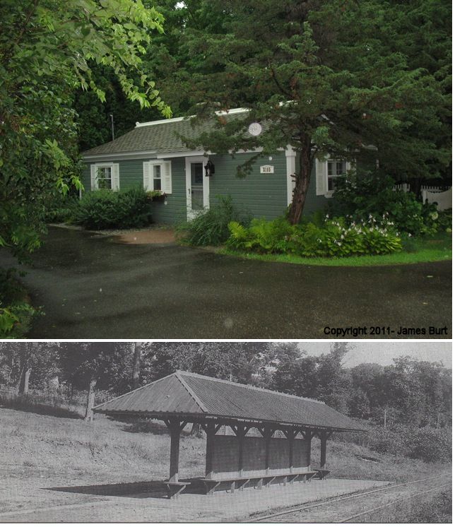
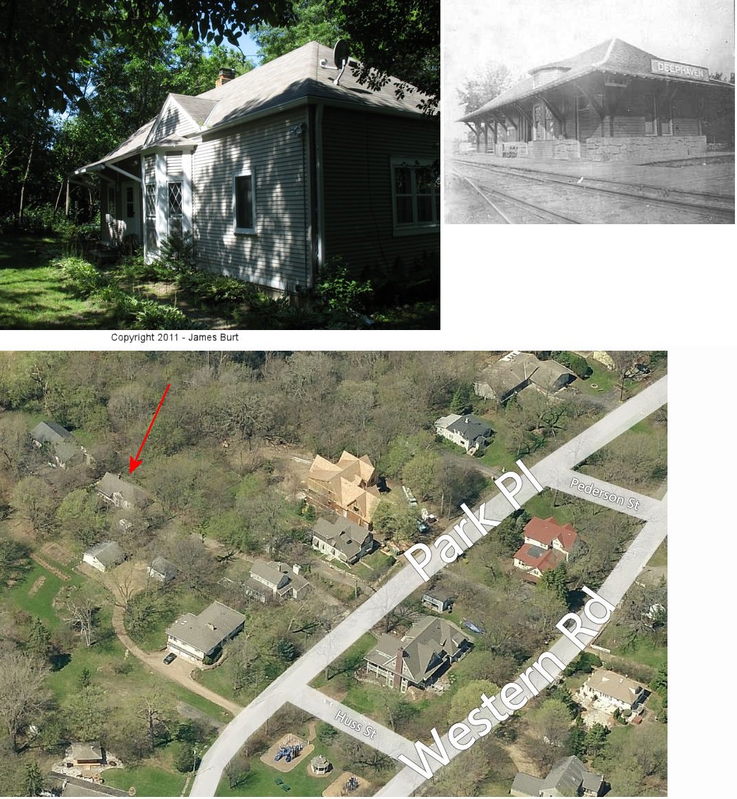
| Deephaven |
 |
3725 Parkway Street, 3rd house north of Azure Road. (GPS: 44.936602, -93.525744) |
C | 1887 | Residence | ???? | Wood |
|
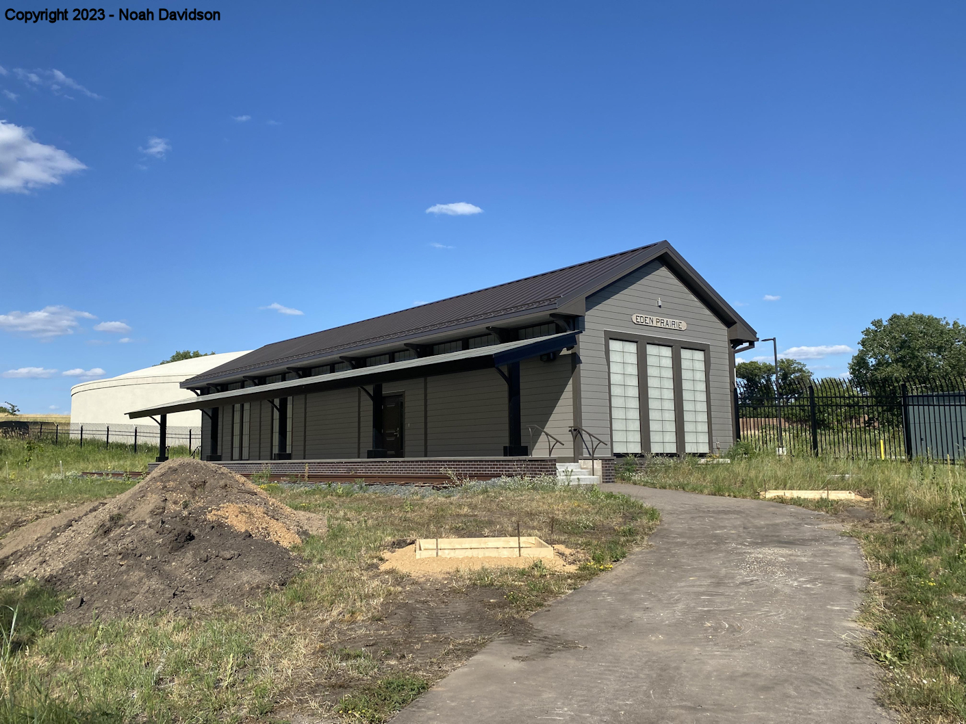
| Eden Prairie |
 |
Next to the bike path between Eden Prairie Road and West 78th Street (GPS:44.856315, -93.481907) |
C | 2022 | Pump Station | None | Wood | |
| Edina (Atwood Spur) |
 |
Behind factory at 7490 Bush Lake Road (GPS:44.867583, -93.361528) |
P | ???? | Vacant | In Use | Wood | |
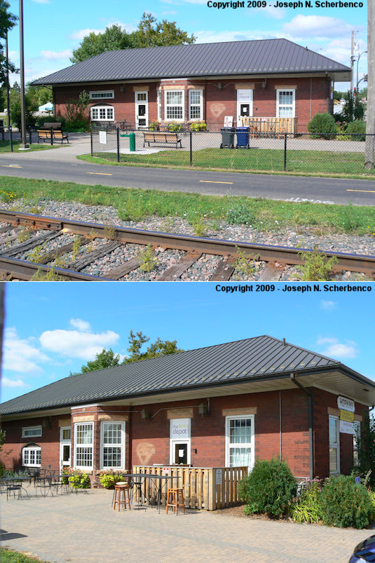
| Excelsior |
 |
305 Water Street (GPS: 44.901692, -93.567034) |
C | 1952 | Museum | None | Wood | |
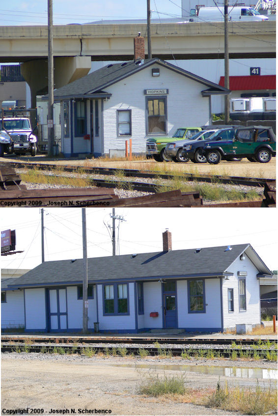
| hopkins |
|
West of the US 169 overpass (GPS: 44.922151, -93.402746) |
C | 1928 | Railroad | In Use | Wood | |
| Hopkins |
|
9451 Excelsior Boulevard (GPS: 44.923762, -93.399268) |
C | 1902 | Business | In Use | Brick |
|
| Manitou Station (Tonka Bay) |
|
4831 Manitou Road (GPS: 44.916893, -93.588516) |
P | ???? | Private | None | Wood |
|
| minneapolis |
|
East corner of Washington Avenue and 3rd Avenue (GPS: 44.980166, -93.263537) |
P | 1899 | Business | Gone | Brick | |
| minneapolis |
|
201 3rd Avenue South (GPS: 44.980796, -93.263193) |
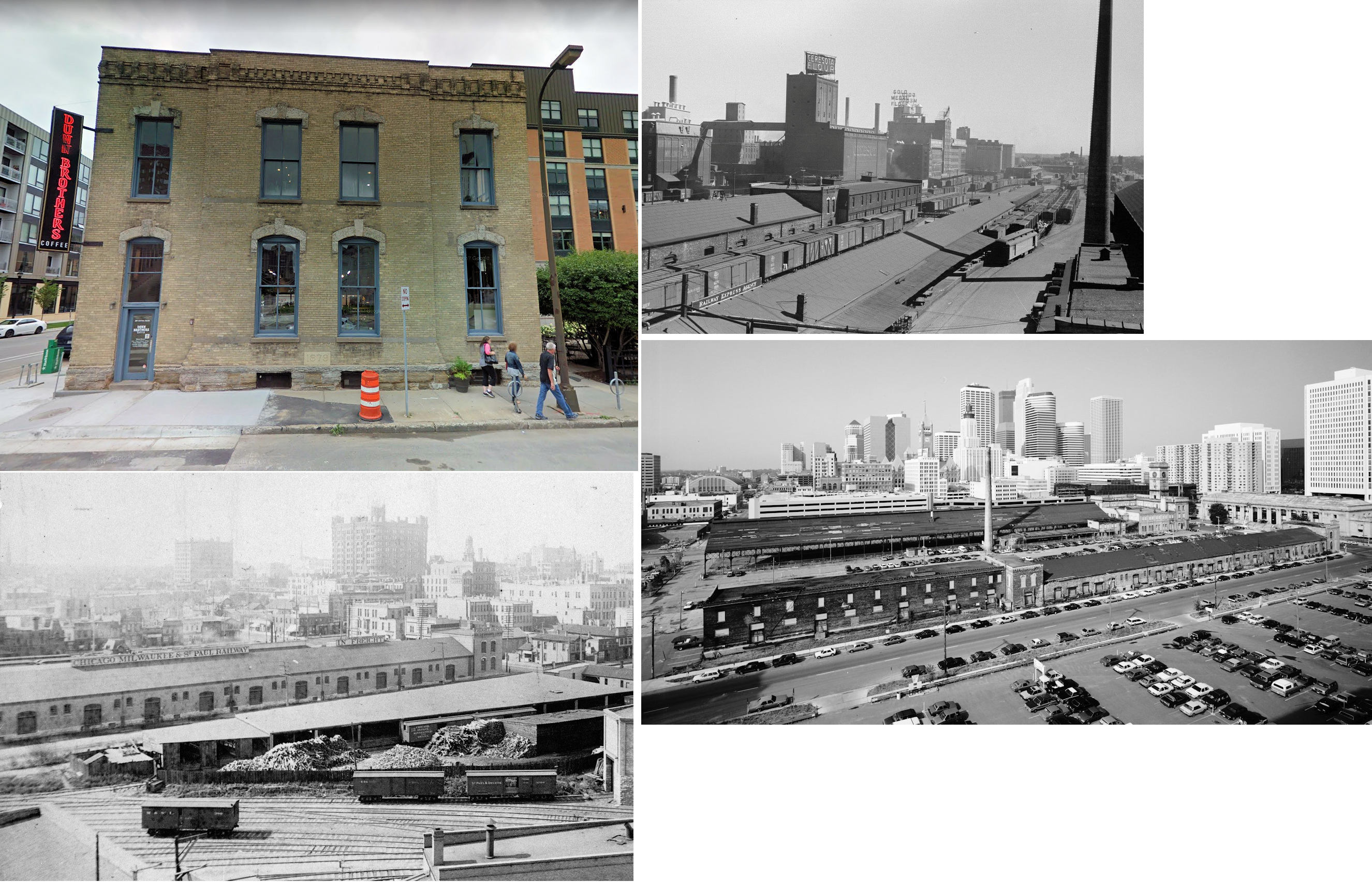
F | 1879 | Business | Gone | Brick | |
| minneapolis |
 |
50 North 4th Avenue (GPS: 44.987691, -93.270771) |
F | 1910 | Condos | Gone | Brick | |
| minnehaha |
|
South Minnehaha Drive in Minnehaha Falls Park (GPS: 44.914171, -93.211312) |
C | 1875 | Civic | Gone | Wood | |
| mound |
 |
5801 Bartlett Boulevard (Surfside Park) (GPS: 44.928353, -93.671120) |
C | 1915 | Civic | None | Wood | |
| St. louis park |
|
Norvig Park at West 37th Street & Brunswick Avenue South (GPS: 44.936969, -93.358022) |
C | 1887 | Museum | None | Wood | |
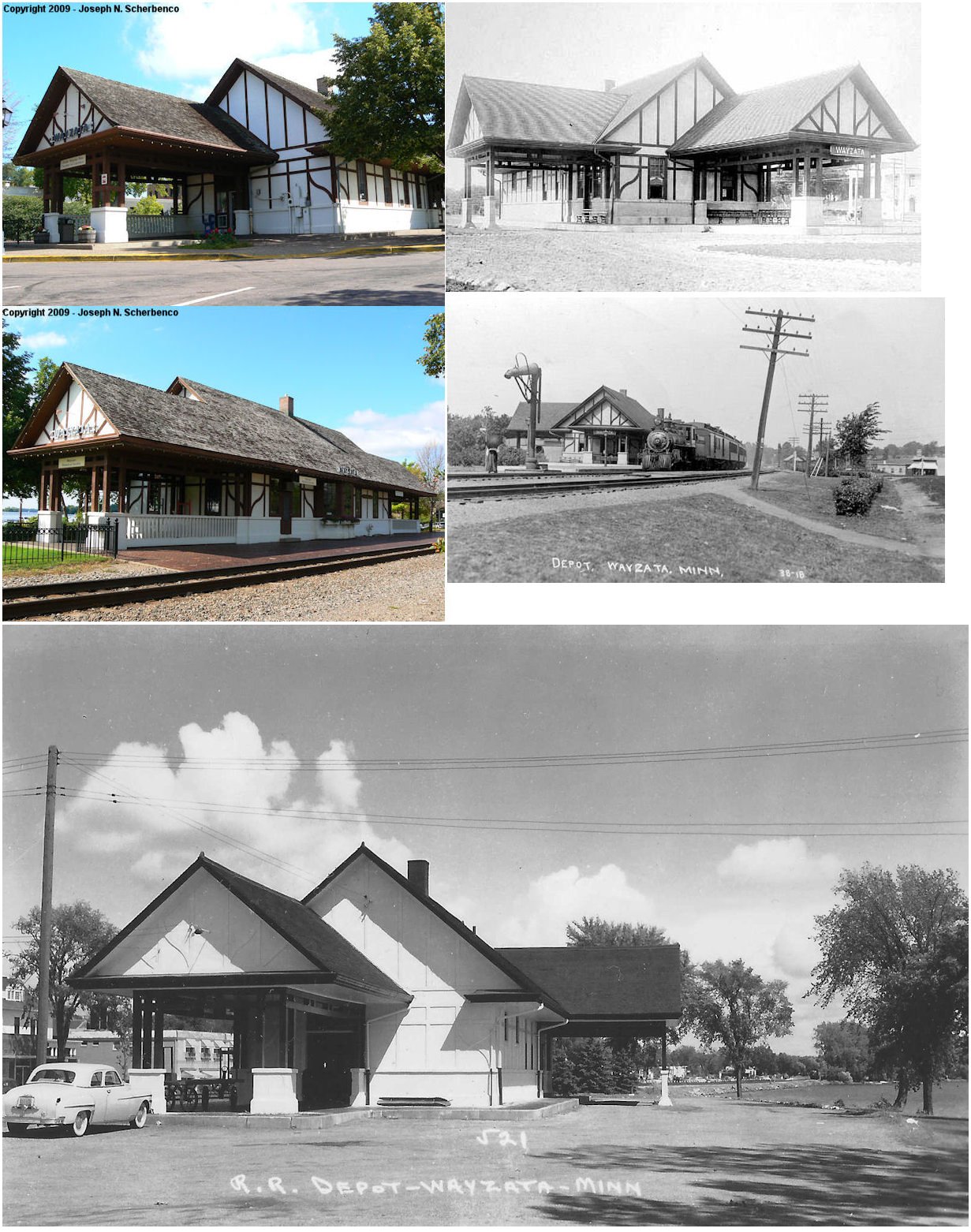
| wayzata |
|
402 East Lake Street (GPS: 44.969890, -93.516308) |
C | 1906 | Museum | In Use | Wood & Stucco |
|
| Woodland (Breezypoint) |
|
3105 Maplewood Road just north of Maple Ridge Road (GPS: 44.946376, -93.514115) |
P | ???? | Residence | Gone | Wood | |
| STATIONS OF THE PAST | ||||||||
| Station Name |
Original Railroad |
Notes | ||||||
| Arcola (Northwood) |
 |
This station was not far to the northeast of the Minnetonka Beach station on the GN's Spring Park Branch. It was located near the intersection of Arcola Lane and Shoreline Drive. The name of the station was changed from "Northwood" to "Arcola" in 1899. The GN abandoned this station in August 1929. | ||||||
| Armstrong |
|
There was a station here before the westward growth of Maple Plain. | ||||||
| Auto Club |
|
This station was on the south side of Auto Club Road on the east side of the tracks at GPS: 44.793830, -93.367755. | ||||||
| Bass lake Station |
 |
Now part of Plymouth, this station was in the vicinity of Zachary Lane North, south of 53rd Avenue. It was a short distance to the east of Staffordsville Station. In 1898, Bass Lake and Staffordsville were the only two stations in the township according to the 1898 Plat Book of Hennepin County. | ||||||
| Bloomington |
|
This station was on the SW corner of Penn Avenue and the Dan Patch Railway at GPS: 44.819501, -93.309240. | ||||||
| Bluff Park |
|
This station was on the west side of Normandale Avenue on the SE side of the tracks at GPS: 44.805472, -93.350722. | ||||||
| Camden Place |
|
The early station here, built in 1888, was a very small building (see photo). In 1956 the station was moved a short distance and enlarged. The station was behind 4056 North Washington Avenue at GPS: 45.029450, -93.284238. After the move it served primarily as a railroad office rather than as a passenger station. It was torn down in 1991. | ||||||
| Cedar Lake |
 |
According to valuation records, this station measured 16' x 37' and was built in 1897. | ||||||
| Cedar Lake |
|
The 1967 Official railway Guide lists CNW as having a freight station in Cedar Lake, so this may have been the original M&St.L freight station (as the CNW took over the M&St.L in 1960). | ||||||
| Cottagewood Station |
|
This station was to the west of the Deephaven Station at the intersection of Cottagewood Road and Minnetonka Boulevard. | ||||||
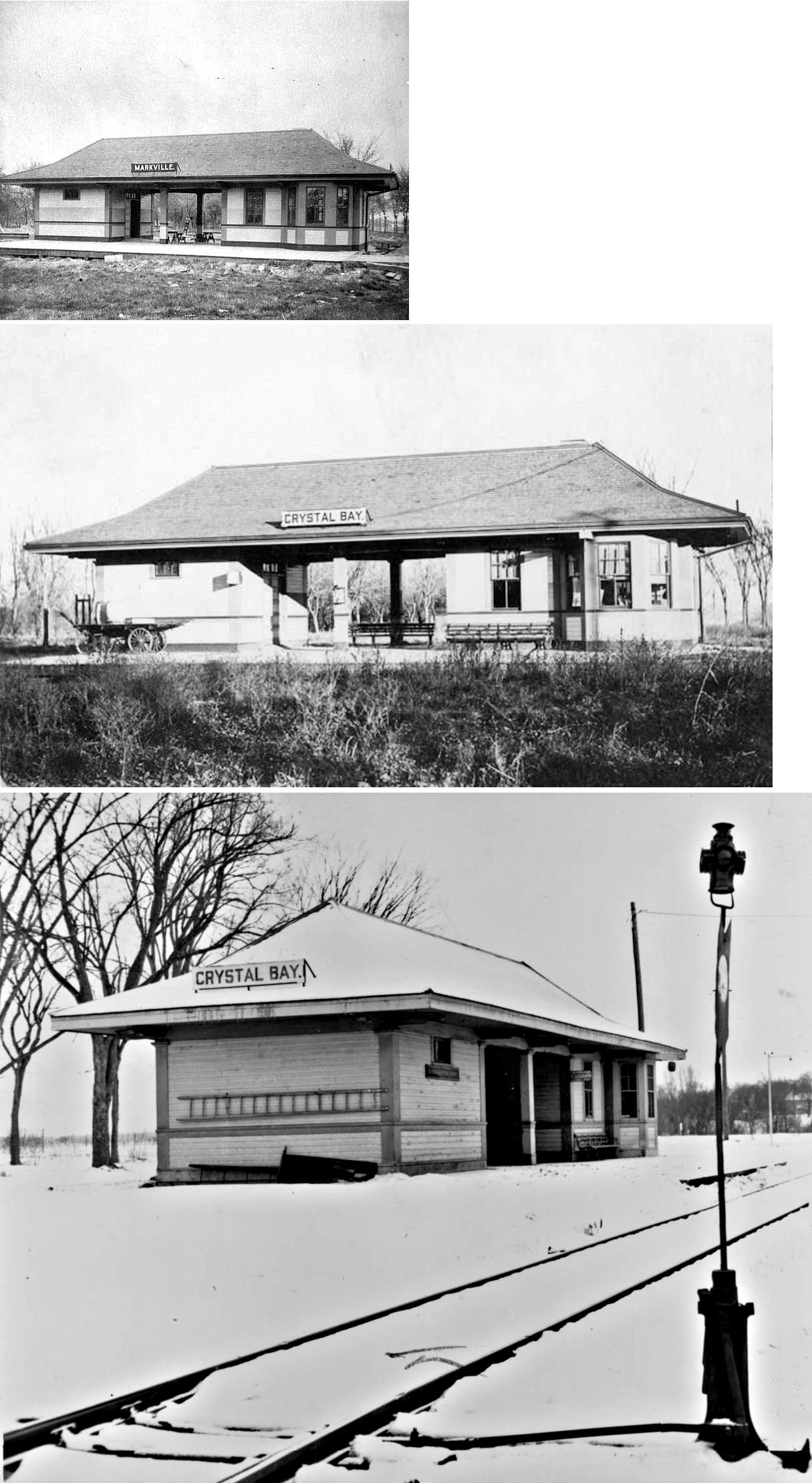
| Crystal Bay (Markville) |
|
This station was on Railroad Avenue just north of North Shore Drive on the east side of the tracks at GPS: 44.953110, -93.576186. The name of this town was changed from Markville to Crystal Bay in 1906. The station is shown on the 1912 Minneapolis Sanborn Map (Vol. 6, Sheet 709). The station was abandoned by the GN in 1959. | ||||||
| Crystal |
|
This station was on the west side of Douglas Drive North between 52nd Avenue North and 51st Place North. | ||||||
| Deephaven |
|
This station was originally on the east side of the bridge across Carson Bay, just west of Chimo West Street approximately where the boat launch is now at GPS: 44.923875, -93.529114. It was moved in the 1920s to 20405 Park Place (GPS: 44.925049, -93.540779). When the station was moved, the top part was taken, leaving the fieldstone foundation at the original site. A gable above the agent's bay was added to modernize it. The station is shown on the 1912 Minneapolis Sanborn Map (Vol. 6, Sheet 710). The station was built by Hazen James Burton, one of the first to build a year-round residence on Lake Minnetonka. He commuted from home to his office in downtown Minneapolis using the train from this station which also served the Hotel St. Louis. The original style of the building was in keeping with the style of the Burton home which was just up the hill from the station. It was torn down in early 2024 to make way for a new house. It its final years it was a rental house located behind 20395 Park Place. | ||||||
| Eddy Station |
|
This station was near where Pond View Drive is today, to the west of Eureka Road. | ||||||
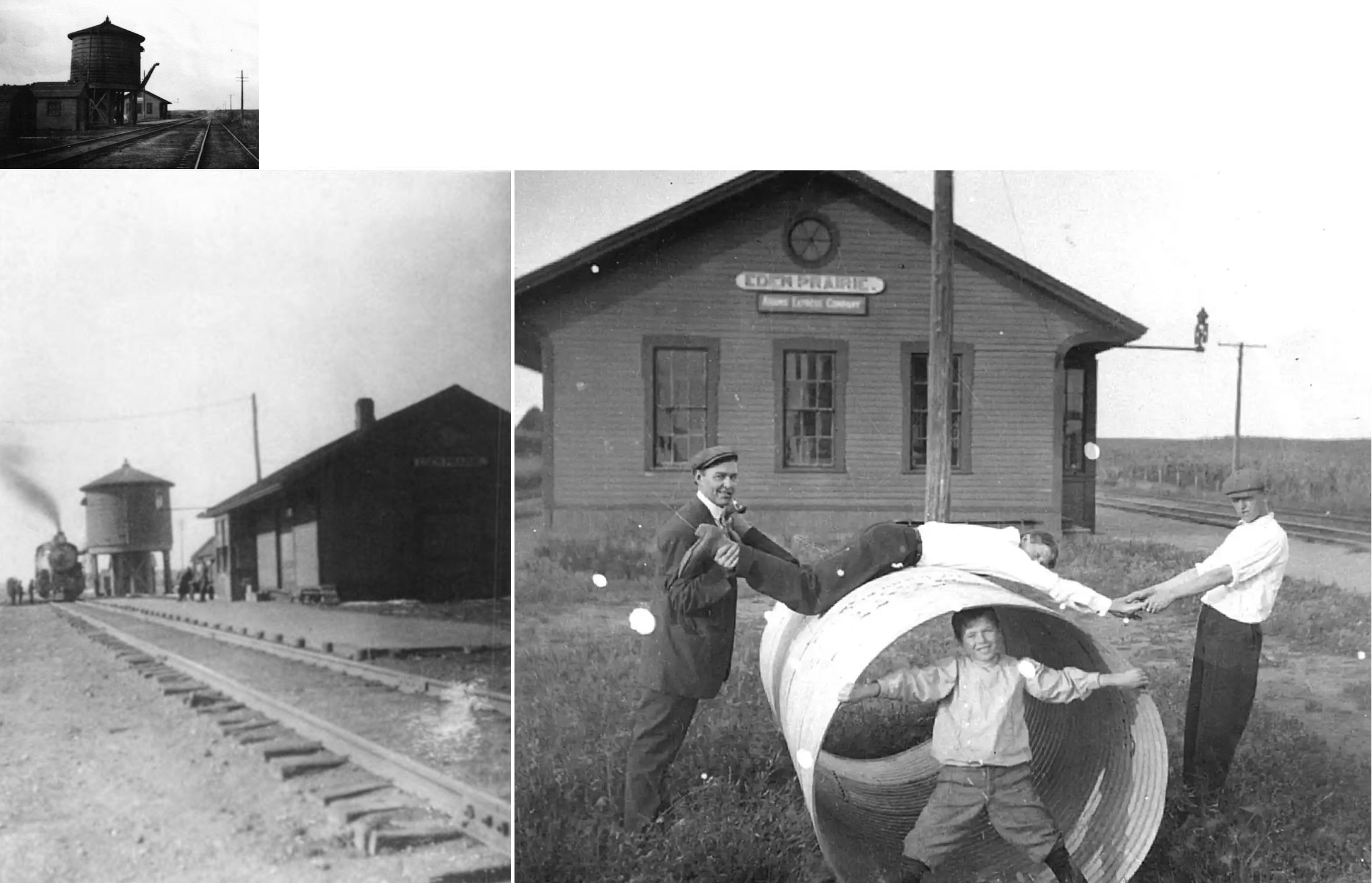
| Eden
prairie (Washburn) |
|
Built in 1871 and torn down in 1934, this station was located east of Eden Prairie Road at approximately GPS: 44.854360, -93.484790. | ||||||
| Edgewood |
|
There was only a platform here in the vicinity of the MN&S tracks and Humbolt Avenue. | ||||||
| Edina (Brookside) |
|
This station was on the east side of Brookside Avenue south of 48th Street in the vicinity of GPS: 44.914942, -93.353640. | ||||||
| Eureka (Walters Grove) |
|
This station was located at the intersection of Smithtown Road, Smithtown Way, and Eureka Road. | ||||||
| Excelsior |
|
This station, built in 1883, predates the existing station. It was in essentially the same location on Water Street at 3rd Street (GPS: 44.901692, -93.567034). | ||||||
| Excelsior |
|
The GN station was right across the tracks from the M&St.L station on the SE side of Water Street. It was on the south side of the tracks. The M&St.L station was on the north side of its tracks. | ||||||
| Fairview |
|
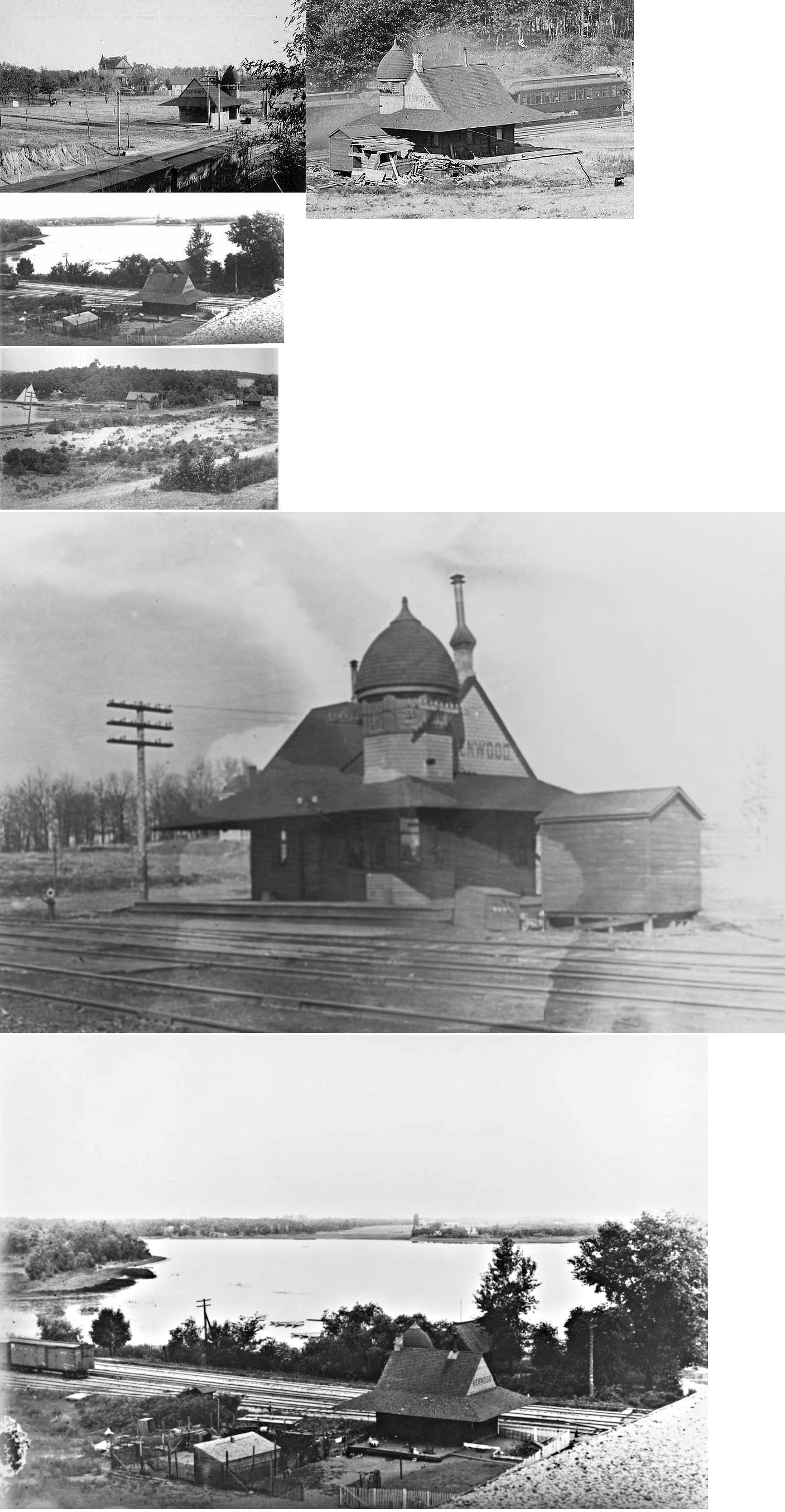
This station was on Fairview Street in the vicinity of Sleepy Hollow Road in the northern part of Greenwood. This station was just a short distance north of the station on Solberg's Point. | ||||||
| Fairview |
|
|||||||
| Ferndale |
|
This station was on the west side of Ferndale Road South in the western part of Wayzata. It was on the south side of the tracks. | ||||||
| Fort Snelling |
|
This station is listed as a suburban station in Gibson's 1888 Suburban Directory and is shown on the 1902 St. Paul, Minneapolis and Environs map from Rand McNally. | ||||||
| Golden Valley |
|
|||||||
| Great Northern Crossing |
AND |
This station was between Bottineau Boulevard and West Broadway Street at GPS: 45.047940, -93.354349. | ||||||
| Groveland Park |
|
This station was somewhere in the area near the intersection of Grays Bay Boulevard and Breezy Point Road. | ||||||
| Hamel |
|
This station was on the east side of Depot Street (now gone), on the north side of the tracks. According to a 2020 article in the "Northwestern Lines," Don Lind bought the 1885 depot and moved it to west of Annandale to an area he wanted to develop as a museum. Frustrated by county requirements, he burned it down in 1987. | ||||||
| Hassan |
|
This early station was in the middle of Section 15 of Hassan Township. This puts it in the vicinity of where Industrial Boulevard crosses the tracks in the vicinity of GPS: 45.203040, -93.574939. It is shown on the index map of the 1898 Plat Book of Hennepin County, but it is not shown on the Hassan Township page indicating that the station may have removed by then. | ||||||
| Harrington Heights |
|
There was only a platform here. It was on West 84th Street (not sure what side of the road/tracks it was on) at approximately GPS: 44.851667, -93.283517. | ||||||
| Holdridge |
|
This station was between Wayzata and St. Albans. It was abandoned by the GN in December 1932. This may be the same station as Wayzata (Lake Junction) listed below at a location just west of the intersection of Bushaway Road and Eastman Lane. | ||||||
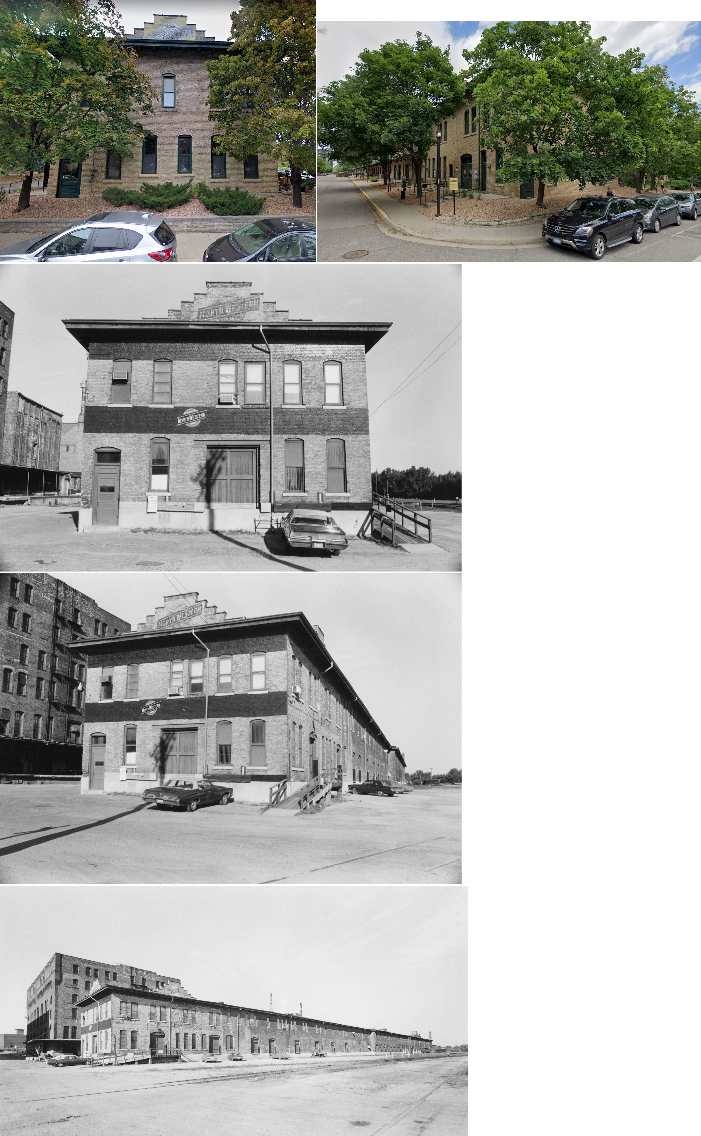
| Hopkins |
|
The old pre-1902 frame station was just to the east of the existing brick station. It was where the large parking lot is today. | ||||||
| Hopkins |
|
The old pre-1928 station was to the east of the existing station. It was on the east side of the overpass near Washington Avenue. | ||||||
| Hopkins Junction |
|
This station was abandoned by the GN in January 1954. | ||||||
| Hotel St. Louis Station |
|
This was a few miles east of Excelsior and served Charles Gibson's Hotel St. Louis. | ||||||
| Hyland Lake (Highland Lake) |
|
There was only a platform here on the east side of the tracks on the SE side of Hyland Lake in the vicinity of GPS: 44.820427, -93.362351. | ||||||
| Kenwood |
|
This station was located near what is now Thomas Avenue South at 21st Street on the west side of Cedar Lake at approximately GPS: 44.961187, -93.314621. It was built in 1887, converted into a residence in 1907 and torn down in 1971 (Minneapolis Star Tribune, 11-18-1995). | ||||||
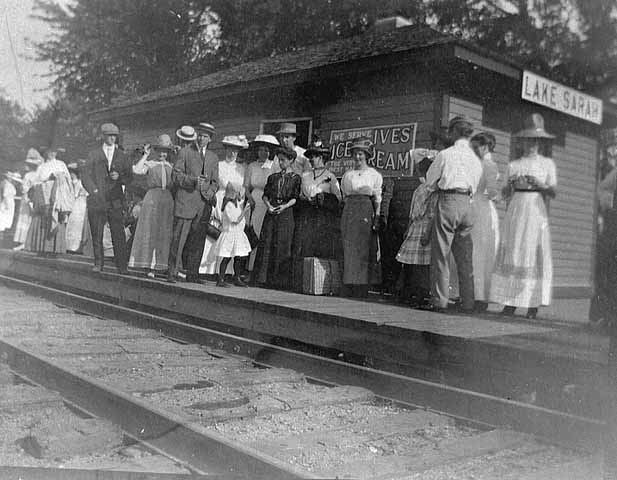
| Lake Sarah |
|
|||||||
| Lincoln Park |
|
This station was between what is now MN-100 and Osseo Road in the general vicinity of GPS: 45.043107, -93.322409. The station is shown on the Rand McNally map for St. Paul, Minneapolis and Environs from 1902. | ||||||
| Linwood |
|
|||||||
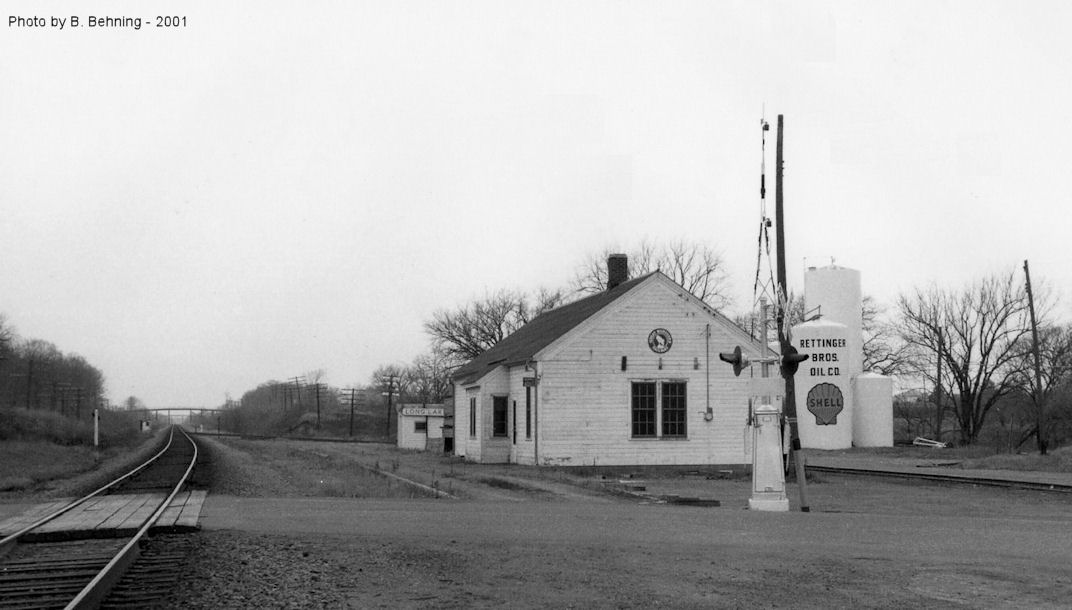
| Long Lake |
 |
The first station was built here in 1867. | ||||||
| Long Lake |
|
This station was on Brown Road North where it crossed the tracks before there was an overpass. According to the 1915 GN Valuation Records, a new station was built here in 1904 that mesured 25'x61'. | ||||||
| Loretto (Loretta) |
|
This station, built in 1886, was on Railway Street West between Lorenz Street and St. John Street at GPS: 45.054150, -93.637632. It was between the main line and the siding. | ||||||
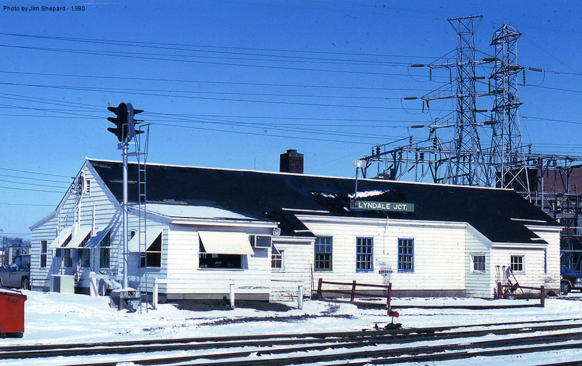
| Lyndale Junction (Clearwater Jct.) |
|
This station was on Linden Avenue West, just SW of Lyndale Avenue. The name was changed from "Clearwater Junction" to "Lyndale Junction" in October 1931. | ||||||
| Lynn Road |
|
This station was at the NE corner of 90th Street and the Dan Patch line at GPS: 44.840922, -93.283449. | ||||||
| Maple Grove (Woodward) |
|
This station was closed by the GN in September 1954. | ||||||
| Maple Plain |
|
This station was moved from Maple Plain to a field at 16350 CR 20, near Watertown (Carver County) where it sat for quite a few years. It was in poor shape in later years, and by 2024-25 it was gone (presumably torn down or collapsed). Photos show it in its original location at in the field after it was moved. Its original location was on Railroad Street between Pioneer and Spring in Maple Plain. According to the 1915 GN Valuation Records, a new station was built here in 1904 that mesured 19'x68'. | ||||||
| Miller Station |
|
|||||||
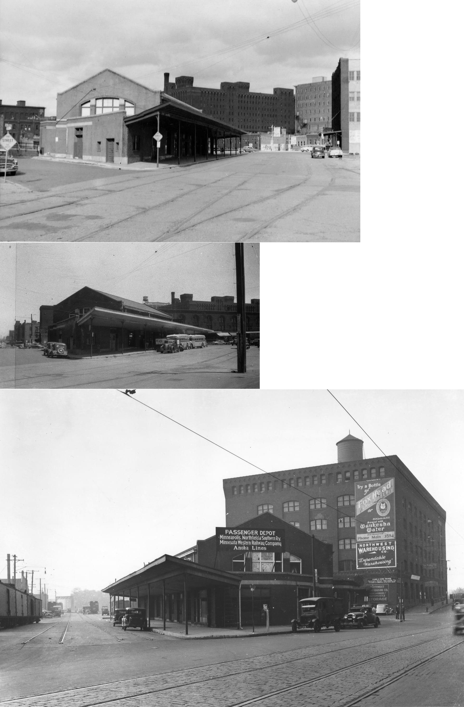
| Minneapolis |
 AND  |
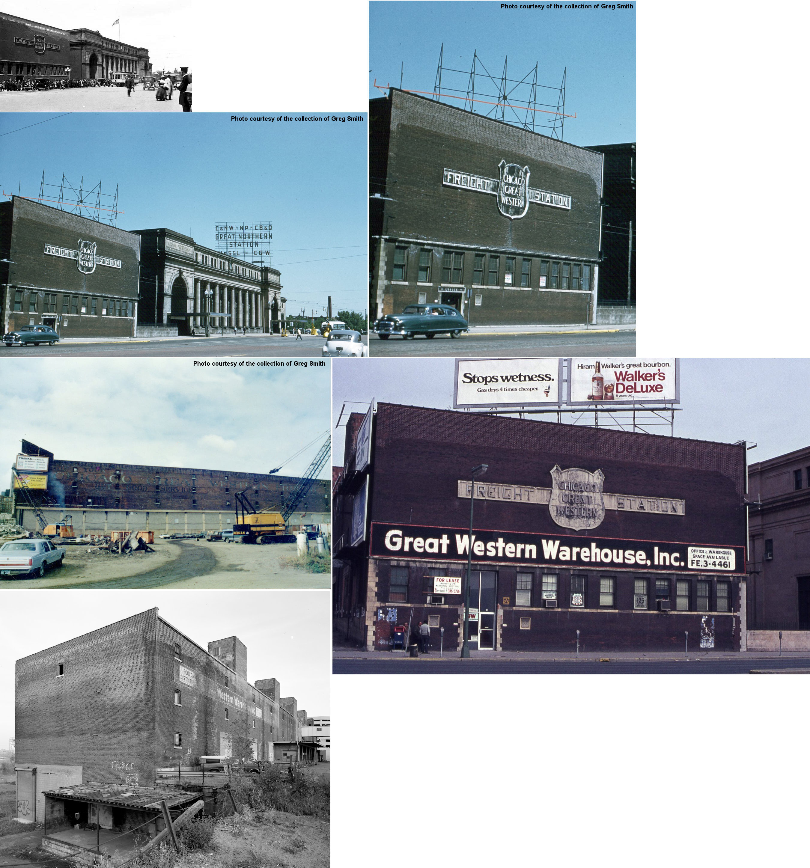
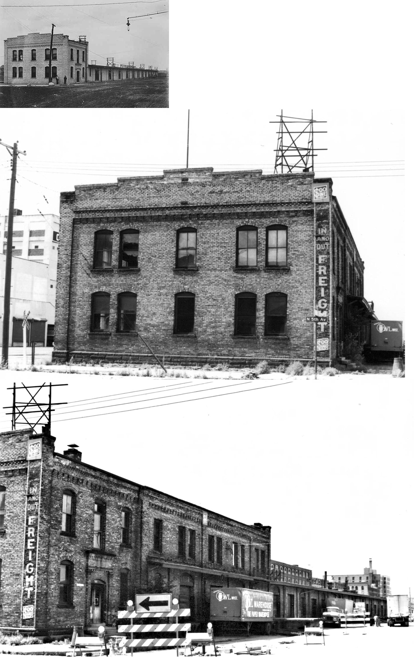
This CGW freight house was on the NW side of Hennepin Avenue across from High Street at GPS: 44.984585, -93.266518. It was next door to (on the SW side of) the Great Northern passenger station. Originally built by the Wisconsin Central, the freight house become redundant after the Soo/WC lease of April 1909 and was then bought by the CGW. This freight house replaced an older one of the 1890s era destroyed by fire on April 26, 1907. | ||||||
|
Minneapolis (Tenth Avenue) |
|
This passenger and freight station was on the east corner of Washington Avenue South at 10th Avenue South at GPS: 44.976237, -93.253967. The passenger station opened at the end of July 1892 (Minneapolis Times, 7-30-1892), but the freight station section was built in 1886 (according to the date stone that was on the front of the building). The CGW leased trackage rights from the Northern Pacific to 10th Avenue South to access this passenger station by backing up a short distance. Prior to this station's opening, the CGW used Union Station and paid rent to the Great Northern there through June 1892 when the lease ended. The station went out of service in 1916 with the station then being leased by the Boyd Transfer and Storage Company. By the 1950s it was used as a salt and grocery warehouse (SuperValu) and was torn down in 1963. | ||||||
| Minneapolis |
 |
The first station in Minneapolis proper was a Minnesota Central Railway combination station on 2nd Street between 4th and 5th Avenues. It was built around 1864-65 and was at approximately GPS: 44.980142, -93.261401. It was the predacessor of the Milwaukee Road station listed below. When the new Milwaukee Road station below was built, the original Minnesota Central station was converted to an Armour meat warehouse. | ||||||
| minneapolis |
|
This station, which sat on Washington Avenue at 4rd Avenue South at GPS: 44.979812, -93.262838, was built in 1879. It was demolished to make way for the "new" station in 1899. | ||||||
| Minneapolis |
|
There was a freight station complex (three buildings), built in 1879, with the two-story head end on the south corner of 3rd Avenue South and South 2nd Street. The head end part remains, but the rest of the freight complex is gone. The in-bound freight building stretched along the south side of 2nd Street from 3rd Avenue to 5th Avenue. The outbound freight station was between the in-bound station and the passenger station and train shed. | ||||||
| Minneapolis |
|
There was a freight station for fruit on the east corner of 3rd Avenue South and South 2nd Street at GPS: 44.981062, -93.262842. This station is shown on the 1912 Sanborn map. | ||||||
| Minneapolis |
|
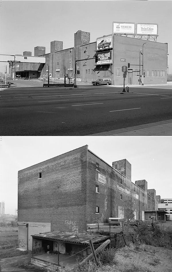
A new fruit and vegetable freight station was built in 1931 near the intersection of 9th Avenue South and Washington Avenue South. The station was of brick and steel construction and measured 65' x 450' (Minneapolis Star, 8-10-1931). | ||||||
| Minneapolis (Short Line Jct.) |
|
The Short Line Junction station was north of East 26th Street at GPS: 44.956598, -93.243191. This station is shown on the 1885 Sanborn map. | ||||||
| Minneapolis (Lake Street) (S. Minneapolis) |
|
The Lake Street (formerly 30th Avenue) station was on the north side of East Lake Street at GPS: 44.948646, -93.237559. This station is shown on the 1885 Sanborn map. It was only half a mile south east of the Shortline Junction station. | ||||||
|
Minneapolis (St. Anthony) |
|
The first station to serve Minneapolis was across the river in St. Anthony on what is now SE Main Street in the vicinity of GPS: 44.985159, -93.257297. It was basically a pair of wooden shacks that were built around 1862. | ||||||
| Minneapolis |
|
This station sat between Washington Avenue North and North 3rd Street at approximately GPS: 44.984646, -93.273849. It dates from the late 1860's/early 1870's. It is shown on the Sanborn map of 1885, but was marked "Old Depot" having been out of service by then and replaced as Manitoba's main station by the new Union Station listed below. The St.P&P became part of the St. Paul, Minneapolis & Manitoba which then became part of the Great Northern. | ||||||
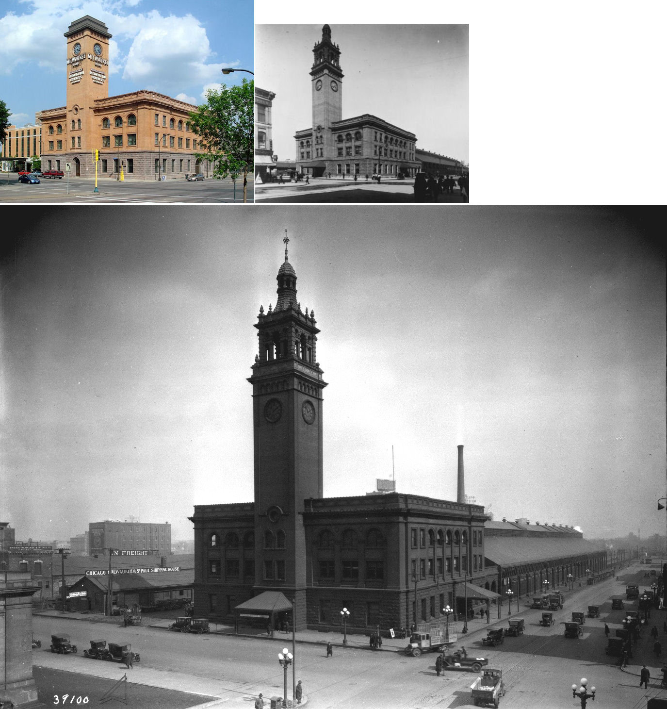
| Minneapolis |
 |
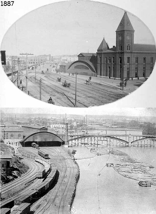
Built in 1883-1884, this was the original Union Station on the east side Hennepin Avenue on the north side of High Street at GPS: 44.984190, -93.264863. This location is now the site of the central Minneapolis Post Office. The station was essentially built and operated by the St.PM&M (Manitoba) under its subsidiary "Minneapolis Union," but was also used by the NP, St.P&D, and the M&St.L. The station partially opened in 1884 (Star Tribune, 9-2-1884), and fully opened in 1885. | ||||||
| Minneapolis |
|
There were two St.PM&M (previously St. Paul & Pacific) freight stations with one being between 4th and 3rd Streets (GPS: 44.984126, -93.275447) and the other being between 3rd and Washington Streets (GPS: 44.984888, -93.274287). These stations are shown on the 1885 Sanborn map, but were torn down and replaced by the GN with new freight stations in the same area. | ||||||
| Minneapolis |
|
The 1885 Sanborn map shows a St. Paul, Minneapolis & Manitoba (previously St. Paul & Pacific) freight station at 50 North 4th Avenue (GPS: 44.987691, -93.270771) at the same location as the existing Omaha freight station that was built in 1910. This older freight station was about half as long as the one that occupies the site now. | ||||||
| Minneapolis |
|
There was a freight station on the north side of where Winter Street SE used to cross the tracks in the vicinity of GPS: 44.993725, -93.229166. The station is shown on the 1885 Sanborn map. | ||||||
| Minneapolis (University Ave.) |
|
There was a passenger station on the north side of University Avenue SE at 14th Avenue SE on the south side of the tracks at GPS: 44.979625, -93.236003. The station is shown on the 1889 Sanborn map and the C.M. Foote map of 1892. | ||||||
| Minneapolis |
|
The GN had inbound and outbound freight stations stretching under what used to be the 3rd Street bridge (now gone) in the vicinity of GPS: 44.984271, -93.274541. These replaced earlier St.PM&M stations that were on opposite sides of 3rd Street. | ||||||
| Minneapolis |
|
This station was located on Hennepin Avenue at Mississippi River at GPS: 44.984982, -93.265994. The site is now occupied by the Federal Reserve Bank of Minneapolis building. Built by the GN in 1913, it was also used by the NP, CB&Q, CNW, M&St.L and CGW. The station was torn down in 1978. | ||||||
| Minneapolis Junction |
|
This station was west of NE Taylor Street and north of Winter Street NE at GPS: 44.993683, -93.244104. It was on the SW side of the tracks, just to the SE of the old roundhouse that was in the middle of the wye. | ||||||
|
Minneapolis (Northtown Junction) |
AND |
This station was at the junction of the NP and GN (and Soo Line) east of California Street NE between St. Anthony Parkway and 31st Avenue NE at approximately GPS: 45.026001, -93.267720. The name of the station was changed from Northtown Junction to Northtown in 1909. A later station here may have been to the north. | ||||||
|
Minneapolis (East Minneapolis) |
|
This brick station was at the NE end of the Stone Arch Bridge at GPS: 44.981405, -93.250014. It was built by the St.PM&M, but used by other RRs (the Minnesota & Northwestern, M&St.L, etc.) as well. On the 1892 map the tracks are labeled "Minneapolis Union Railway" (the short line of the Union Depot) so the station may have been a joint effort under the control of Minneapolis Union Railway. | ||||||
| Minneapolis |
|
This inbound freight station was located on the western corner of 5th Avenue North and 2nd Street (GPS: 44.986972, -93.273947). Some sources say it was built in 1915, however it is shown on the 1912 Sanborn map. The outbond frieght station was also on 2nd Street, but on the southern corner with 5th Avenue at GPS: 44.986666, -93.273523. This southern building was owned by the Minneapolis Terminal Warehouse Company on the 1951 map, whereas the northern building was still owned by the Soo Line. | ||||||
| Minneapolis |
|
The first Soo Line station in Minneapolis opened in 1884 and was on 2nd Street at 6th Avenue (when it intersected there) at GPS: 44.987875, -93.274580. It was a two-story wood frame building. | ||||||
| Minneapolis |
|
In 1892 the Soo opened a new brick passenger station on the north corner of 2nd Street North and 4th Avenue North at GPS: 44.986391, -93.272378. | ||||||
| Minneapolis |
|
A new passenger station was opened on October 15, 1900 on the NW side of 5th Avenue North between 2nd Street and Washington Avenue (Minneapolis Daily Times, 10-13-1900) at GPS: 44.986660, -93.274372. This was a smaller station as the Soo had service at the time to the Milwaukee Road station where it saw most of its passenger traffic. | ||||||
| Minneapolis |
|
There was a passenger station on the east side of North Penn Avenue just south of 47th Avenue North at GPS: 45.039700, -93.309054. | ||||||
| Minneapolis (Hillside) |
|
This station was just northeast of the entrance to Hillside Cemetery at the east end of 19th Avenue NE at GPS: 45.007755, -93.223976. | ||||||
| Minneapolis |
|
The first Minneapolis M&St.L passenger station was on the SW side of 3rd Street NW of 3rd Avenue at GPS: 44.983967, -93.274462. | ||||||
| Minneapolis |
|
A second generation passenger station was on the NE side of North Washington Avenue between 3rd and 5th Streets on the south side of the tracks at GPS: 44.985344, -93.273222. This brick station is shown on the 1892 C.M. Foote Map and the 1912 Sanborn Map, but is gone by the 1951 edition. | ||||||
| Minneapolis (10th Avenue) |
|
There was a station on the NW side of 10th Avenue South at GPS: 44.977889, -93.253603. It is shown on maps from 1892 and 1903. The building is marked "RR Office" on the 1912 Sanborn Map so it may have closed as a station by then. Later, the building was torn down and this became the site of a General Mills Elevator. This was likely a short-lived communter station that served the nearby mills. | ||||||
| Minneapolis |
|
There were two M&St.L freight stations near the passenger station with one being between 4th and 5th Streets (GPS: 44.982834, -93.276007) and the other being between 4th and 3rd Streets (GPS: 44.983661, -93.274910). These stations are shown on the 1885 Sanborn map. Other generations of M&St.L freight stations occupied this area in later years with newer brick ones built in 1890 (see photos/map). | ||||||
| Minneapolis |
|
There was a small passenger station on the west side of Harrison Street north of 9th Street. | ||||||
| Minneapolis |
|
There was a passenger station on the south side of the tracks between Malcolm Street and East 30th Street at GPS: 44.971885, -93.212193. | ||||||
| Minneapolis (West End) |
|
This station was south of Cedar Lake at the SE end of Depot Street on the west side of the tracks at GPS: 44.952262, -93.320443. | ||||||
| Minneapolis |
|
There was a two-story, wood frame passenger station on 2nd Street just NW of 8th Avenue at GPS: 44.984888, -93.274287. It was built in 1884 (Star Tribune, 6-22-1884). This area is now the site of the Star Tribune Building. | ||||||
|
Minneapolis (East Minneapolis) |
|
This station was east of Johnson Street NE and south of Broadway Street NE at approximately GPS: 44.997238, -93.236006. | ||||||
| Minneapolis |
|
There was a freight station along the SW side of North 1st Street NW of 8th Avenue at GPS: 44.990415, -93.276607. This area is now the site of the Star Tribune Building. | ||||||
| Minneapolis |
|
This freight station/warehouse was in the Warehouse District at 10-12 Hennepin Avenue. | ||||||
| Minneapolis |
|
The freight station that still exists at 50 4th Avenue North was the inbound Omaha freight station. The outbound freight station was on the NE side of of 1st Street just south of Plymouth Avenue at GPS: 44.990998, -93.276417. It was on the opposite side of the street as the NP freight station. | ||||||
| Minneapolis |
 |
There was a long freight house on the south side of South 4th Street at 9th Avenue South at GPS: 44.974516, -93.257300. This area is now part of the site of U.S. Bank Stadium. The station is shown on the 1912 Sanborn map. On later maps it is shown as a CRI&P "Fruit House." | ||||||
| Minneapolis |
|
There was also a smaller freight house on the south side of South 4th Street at 10th Avenue South at GPS: 44.973824, -93.256134. This area is also now part of the site of U.S. Bank Stadium. | ||||||
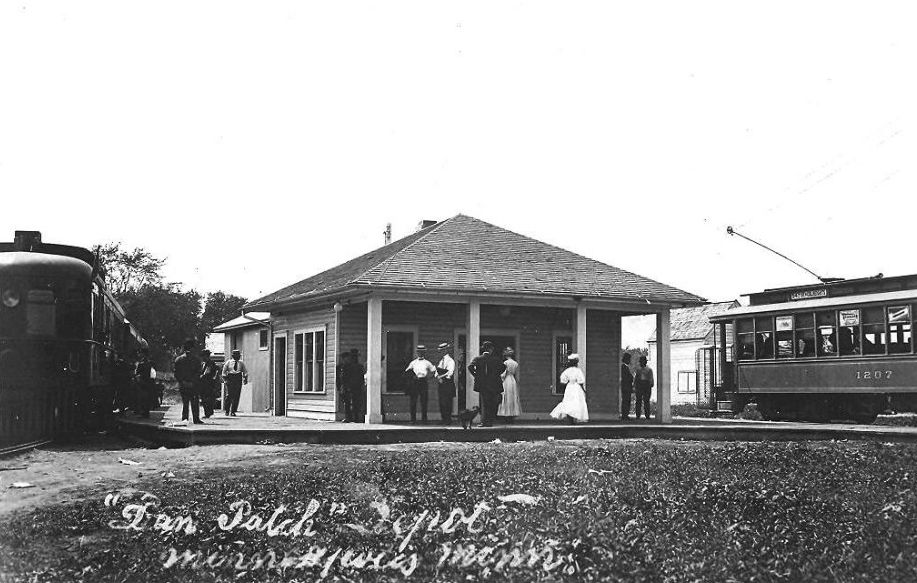
| Minneapolis |
|
This was the original depot at the starting point of the Dan Patch line at 54th and Nicollet. Minneapolis' Nicollet streetcar line ended at that spot, so passengers could easily transfer to the adjacent Dan Patch system. The railroad came in one one side of the station while the streetcar line came in on the other. | ||||||
| Minneapolis |
AND  |
This joint Dan Patch/Luce Line station was at North Holden Street (formerly Hoag Avenue) at 3rd Avenue North. This area is now occupied by I-394 just southwest of Target Field in the vicinity of GPS: 44.979550, -93.279431. | ||||||
| Minnetonka Beach |
|
This station was near the intersection of Westwood Road and Cottage Lane near the entrance to the Lafayette Club. The station was on the south side of the tracks at approximately GPS: 44.940795, -93.596661. It is shown on the 1912 Minneapolis Sanborn Map (Vol. 6, Sheet 707). This was on the GN Spring Park Branch line. The station was abandoned by the GN in January 1954. | ||||||
| Minnetonka Lake Park |
|
This station was to the NE of Minnetonka lake Park Hotel. It was on Dakota Avenue due north of the Lyn Haven Pavillion. | ||||||
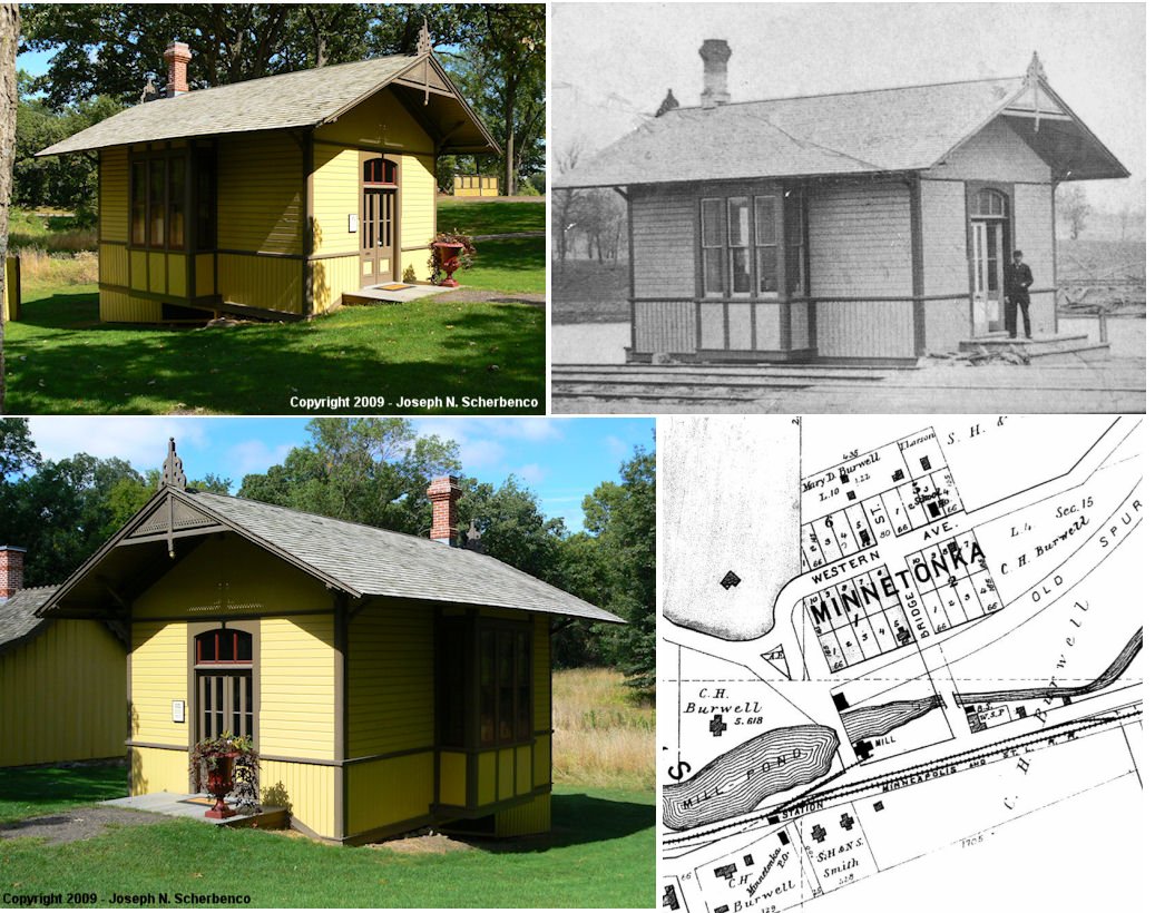
| Minnetonka (minnetonka Mills) |
|
There is a building that looks like a station at Burwell Historic Park at Minnetonka Boulevard & Cedar Lake Road, but this was a scale house and office for the mills there rather than the station. According to old maps there was an MSt.L station nearby. In 1898, the station was on the south side of the mill pond which was on Minnehaha Creek. This was in the Minnetonka Mill Company Subdivision. | ||||||
| Minnetonka |
|
I am not sure if there was a GN station at Minnetonka. Old maps show a spur off the GN line leading to the site of Minnetonka Mills near the town. | ||||||
| Miroc (Lake Riley) |
|
This station was located on the east side of Lake Riley | ||||||
| Navarre (Langdon Park) |
|
This combination station was located at 2273 Shadywood Road (CR 19) (Shadywood Road& Chrystal Place). Around 2009 or 2010 the City of Orono had the building demolished as it was partially on the property owned by the rail authority that bought the rail corridor from Wayzata to Hutchinson. For many years the depot was used as a house. The name of the station was changed from Langdon Park to Navarre in 1902 and the station was abandoned in 1954. | ||||||
| Nesbitt |
|
There was only a platform here on West Old Shakopee Road at GPS: 44.807829, -93.346423. | ||||||
| Orono |
|
This station was on Boardman Avenue at Brackett Avenue (both gone or changed). The GN closed this station in December 1928. | ||||||
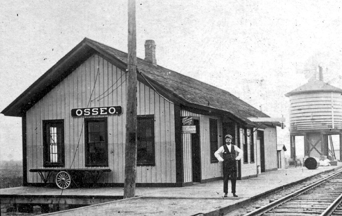
| Osseo |
|
In 1898 the station was on the corner of Madison and Washington Streets. Due to the construction of MN-81, these streets no longer exist/meet at that location. Specifically the station was located at (GPS: 45.114307, -93.401376). In the early days (1870s) this part of town was known as "Attraction." According to the 1915 GN Valuation Records, the station standing at that time mesured 24'x60'. | ||||||
| Osseo |
|
|||||||
| Oxboro Heath |
|
This depot/platform was on the south side of the tracks and a few feet east of Lyndale Avenue at GPS: 44.831611, -93.288500. | ||||||
| Palmer |
|
There was only a platform here about 1/4 mile west of France Avenue in the vicinity of GPS: 44.812574, -93.332780. | ||||||
| Prospect Park |
|
This short-lived station was one of the "Parks" commuter/freight stations between downtown Minneapolis and St. Paul. The next down the line was "St Anthony Park" (Ramsey County). The Prospect Park station was put out of business for passengers after the interurban streetcars began running on University Avenue after 1893. This station is shown on the Rand McNally city map from 1891. | ||||||
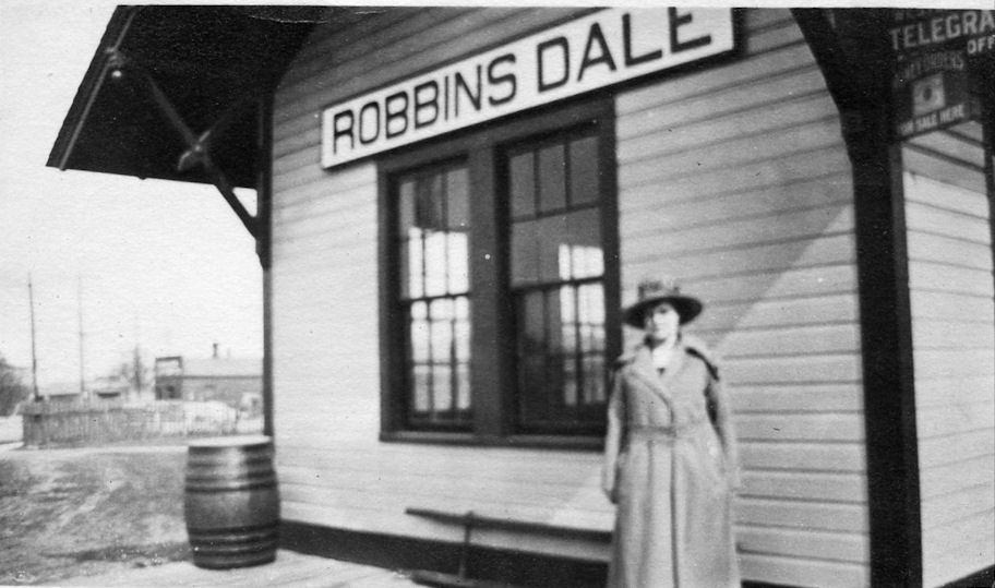
| Robbinsdale (PArker Station) |
|
This station was on Railroad Avenue south of 42nd Avenue North on the east side of the tracks at GPS: 45.031183, -93.341328. The first station here was built in 1888 and called "Parker Station" in honor of Alfred Parker who donated the land for the station. According to the 1915 GN Valuation Records, the station standing at that time (likely the second generation) measured 16'x26'. The history of the station is unclear. The first station at Parkers Station, what would later become Robbinsdale, was built here in 1888. At some point in the late 1800s/early 1900s the GN stopped service to Robbinsdale. In 1903 the town appealed to state railroad commission to force the GN to resume service. The RR commission visited Robbinsdale that year and one newspaper article about implied that there was a station there at the time, just no service. Another article said that "the village wants the depot rebuilt and passenger service resumed" (The Minneapolis Journal, 9-10-1903). It's not clear if this means there was no station building and a new one was needed or if there was one and it needed to be "rebuilt" as in remodeled). As of 1908, there still was no service or agent at the station and the RR commission again ordered the GN to put and agent there during business hours(The Minneapolis Journal, 8-21-1909). In 1946, the GN promised $19,000 to build a new station at Robbinsdale (Minneapolis Daily Times, 4-4-1946), but in 1948 that turned into a $20,000 repair job. The existing station at that time got a new foundation, siding, doors and the glass block windows (The Minneapolis Star, 5-25-1948). This cropped roof style was typical of GN station remodels of the time. According to the book, "Robbinsdale Then and Now" by Helen Blodgett, a new station was built in 1948, but that contradicts the aforementioned newspaper article. The station was demolished in 1967. | ||||||
| Rockford (Goodwin) (Marmion) |
|
The original 1-story station here was built in 1886. A new 1-and-2-story station was built in 1909, but burned down in 1911. A station of identical size was then built to replace that one later in 1911. | ||||||
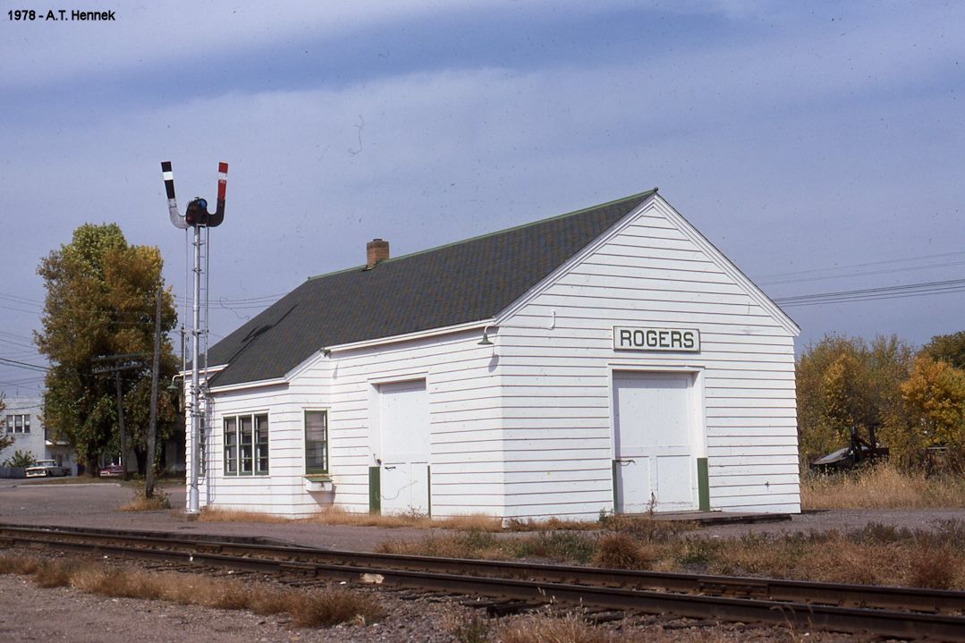
| Rogers |
|
According to the 1915 GN Valuation Records, a new station was built here in 1902 that mesured 24'x48'. | ||||||
| Seton |
|
This station was on the north side of the tracks just south of the east end of what is now Northern Road at approximately GPS: 44.937251, -93.644739. It was abandoned by the GN in January 1954. | ||||||
| Shoreham (Sandy Lake) |
|
This station was about 150 feet north of the (former) derelict roundhouse at the former Soo classification yard, Shoreham, Columbia Avenue North and 28th Avenue NE, Minneapolis (GPS: 45.020899,-93.251052). It was built in 1887. First called Sandy Lake, then Shoreham, by the Soo at its yards near Columbia Heights. This building is shown as a combination station on the 1912 Sanborn Map (Vol. 7, sheets 837-838). It was torn down in 2019 around the same time the old roundhouse was demolished. During the Shoreham Yard's heyday, there were both passenger and freight stations here as part of the complex. | ||||||
| Solberg's Point (Meadville Park) |
|
This station was on the west side of Minnetonka Boulevard south of Vine Street on Solberg's point south of Meadville Park. The station was right on the point near a steamboat landing site right near the trestle over the connection between St. Albans Bay and Excelsior Bay. | ||||||
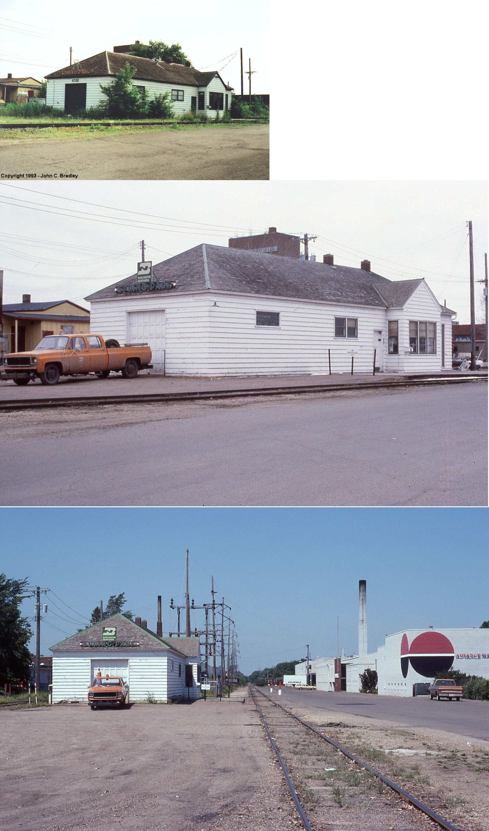
| Spring Park |
|
This station was near the intersection of Northern Avenue, West Arm Drive, and Sunset Drive at GPS: 44.936177, -93.626090. The 1898 map shows this as the terminus of the Spring Park Branch. The station is also shown on the 1941 Sanborn Map. | ||||||
| Spring Park |
|
A later-generation station. | ||||||
| St. Albans Station (Minnetonka Mills) |
|
This station, according to the 1873 map, was located north of where Statnton Drive is today west of Plymouth Road in Minnetonka Township at GPS: 44.94716,-93.445061. | ||||||
| St. Bonifacius |
|
|||||||
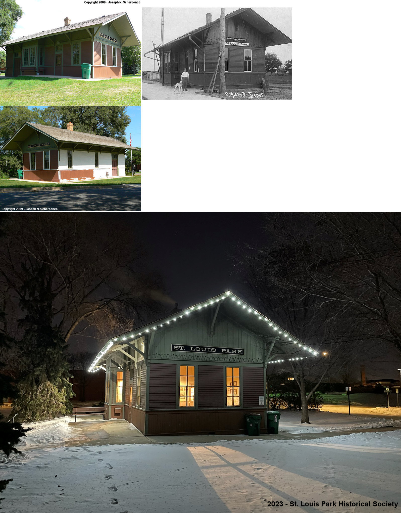
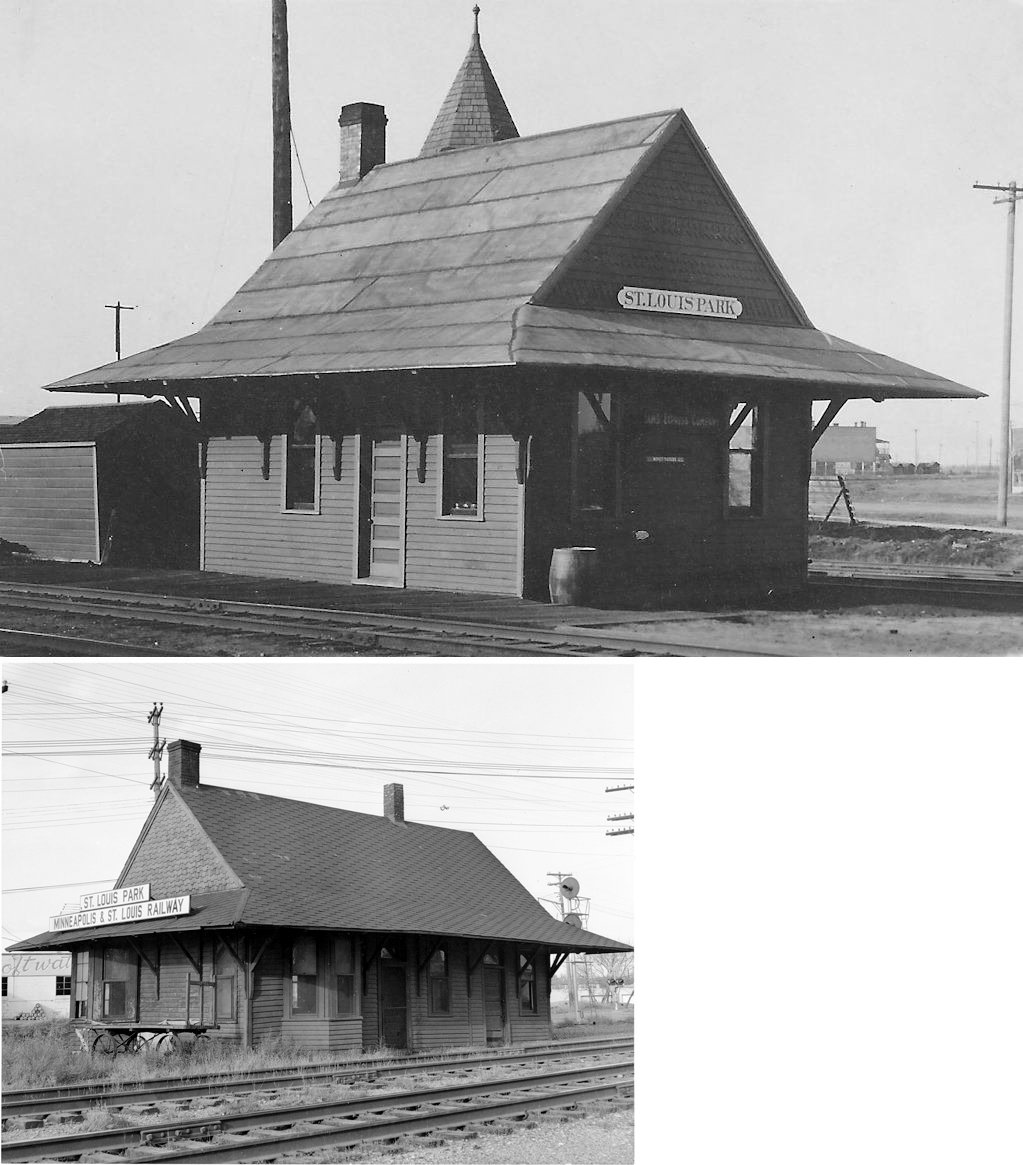
| St. Louis Park |
|
This station was west of where Brunswick Avenue (formerly Grant Street) used to cross the tracks at GPS: 44.937635, -93.357969. There was a freight station on the east side of the street crossing at GPS: 44.937793, -93.357486. The passenger station was damaged by fire in 1963 and subsequently torn down in 1964. | ||||||
| Staffordsville |
|
This little village is part of Plymouth now. Is was to the SW of Bass Lake. The station was located on Plainview Lane North between 52nd and 53 Avenues. | ||||||
| Wayzata (Lake Junction) |
|
The original station was near the corner of Broadway Avenue South and Lake Street East (next to the former Hart's Cafe and current site of Cov). In 1894 that station was moved about a mile east to a location just west of the intersection of Bushaway Road and Eastman Lane. When James Hill moved back to Wayzata in 1906, he built the existing station (Minneapolis Star, 9-17-1981). | ||||||
| Wildhurst |
|
|||||||
| Wilson |
|
There was only a platform here. It was on the south side of West 78th Street on the west side of the tracks at approximately GPS: 44.862161, -93.283512. | ||||||
| Zumbra Heights |
|
|||||||
| 1898 HENNEPIN COUNTY RAILROAD MAP | ||||||||
 |
||||||||
|
Notes About Existing Stations... Deephaven (CMSt.P&P) - The Milwaukee buillt the line in 1887 to serve the Hotel St Louis on Lake Minnetonka, so the station was probably built in 1887. Service ended in 1900 when the hotel closed and the RR sold the ROW to the trolley line. The trolley line improved improved the ROW and ran cars out to the hotel. Edina (Atwood) (MN&s) - This small passenger shelter has almost completely collapsed. Up until the early 2020s, the station sign was still attached to the shelter. Hopkins (M&St.L) - Now houses the Depot Coffee House. The station was moved slightly to the NE from its original location. Manitou (Tonka Bay) (M&St.L) Maps show this station was on the west side of Manitou Road just south of Brentwood Avenue. It may have been moved and converted into a residence at the address listed or this could be a station of a different time period in its original location (more likely). The property for the residence on which the station is located is the old ROW. Minneapolis (CMSt.P&P Passenger) - Station went out of service in 1971. Here is an old photo of the station when it still had a pinnacle on the tower (the pinnacle was destroyed by high winds in 1941). The station now houses two hotels, an ice rink and a water park. For more information see The Depot Minneapolis. Minneapolis (CMSt.P&P Freight) - Only the head house of the station remains here. It now houses a Dunn Brothers coffee shop. Minnehaha (CMSt.P&P) - The station is part of the Minnesota Transportation Museum. It was referred to a "The Princess" due to its Victorian gingerbread architecture. This is the second station at the site, having replaced an earlier frame station. It was closed by the railroad in 1963. Mound (GN) - This station was originally located on the east side of Commerce Boulevard (formerly Main Street) on the south side of the tracks at GPS: 44.937165, -93.665463. It was moved about a mile to the park in 1967. St. Louis Park (CMSt.P&P) - Relocated to a park and now houses the St. Louis Park Historical Society. The original location of the station was on the south side of the tracks between Brunswick (formerly Grant) and Alabama (formerly Jackson) Avenues at GPS: 44.937730, -93.356982. Wayzata (GN) - Now houses the Wayzata Historical Society. The railroad turned the station over to the city in 1972. Woodland (CMSt.P&P) - There is a building here that could have be the station. Apparently there was an open sided station here and it was converted into a house. It is unknown wheteher this was the original Milawaukee Road station or a later TCRT trolley line station. |
||||||||